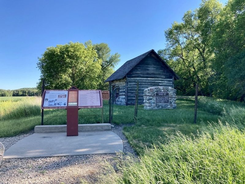
A Tribute to Pioneer Living
This small cabin was constructed in 1878
by Norwegian immigrant Carl Bjerke
Jensen and his nephew John Bjerke.
Carl moved to Dakota Territory from
Minnesota with his father, Jens, and
brothers, Hans and . . . — — Map (db m176586) HM
Kathryn, a typical prairie town, sprang
from the landscape with railroad
construction. Although the area was
settled by pioneers in the late 1870s, the
arrival of a Northern Pacific Railroad line
in 1900 and the establishment of a
cooperative . . . — — Map (db m176712) HM
Waldheim Church
During the mid-1880s, the Sheyenne
River Valley was beginning to fill with
settlers, many of whom were
Scandinavian Lutherans eager to
follow faith and tradition in providing
religious instruction to their . . . — — Map (db m177201) HM
Walker’s Best
The Walker family, Minnesota emigrants,
had milling in their blood. In 1879, Hiram
Walker established a mill in Valley City.
A few years later, his son Myron took over
and built a new mill at Oakville—he later
bought . . . — — Map (db m177164) HM
In 1879, land developer B.W. Benson cleared this land of the densely covered brush and platted it for residential development along the Sheyenne River. He set the center area aside for a park. Later, Benson sold the entire tract to the city for the . . . — — Map (db m242288) HM
The original bridge in this location was a wooden structure built in 1898. The citizens requested this bridge to access new development in the "Normal Park" addition being developed at that time. The wooden structure was replaced by a concrete . . . — — Map (db m242397) HM
King School
When the last students walked out of the
King School in 1967, their departure
marked the end of an era—the closure of the last operating one-room schoolhouse
in Barnes County. Once, over 100 of these
tiny institutions dotted . . . — — Map (db m175564) HM
Sheyenne River The river was formed by the meltwater of the Wisconsinan glacier about 13,000 years ago. The valley constitutes the glacier's western edge at that time. Flowing 581 miles from its headwaters located 15 miles north of . . . — — Map (db m242287) HM
At 581 miles, the Sheyenne River is the longest in North Dakota. When the Wisconsinan ice sheet melted about 13,000 years ago, it left behind the Sheyenne River and a trench that reaches up to 300 feet deep and a mile wide. Discover historic, . . . — — Map (db m242596) HM
Named in honor of Brevet Major General Joseph Gilbert Totten, Fort Totten protected overland transportation and communication routes from Minnesota to the Missouri River and Montana. In addition, the treaty of February 19, 1867, provided for a . . . — — Map (db m231947) HM
From the populated villages of Ukraine to the unsettled regions of North Dakota, the Ukrainian immigrants came here at the end of the 19th century. They emigrated from the “Bread Basket of Europe” to the virgin sodland yet untouched by man – from . . . — — Map (db m178102) HM
The American cowboy has become a mythical figure in the national consciousness. This would, no doubt, have surprised most of the common laborers who earned meager pay as cowboys. A number of them were indeed colorful characters. Some became outlaws . . . — — Map (db m88061) HM
In memory of Antoine Manca de Vallombrosa Marquis de Mores Lieutenant French Cavalry Born in Paris 1858 Killed in North Africa 1896 and of his wife Medora who founded this town in 1883 — — Map (db m87539) HM
Before you lies a scene not greatly changed since Theodore Roosevelt’s time here in the 1880s. Gone are the ambitious De Mores Packing Plant, the military cantonment and the early village of Little Missouri. But still present are the colorful . . . — — Map (db m154615) HM
The Marquis de Mores, a charismatic French nobleman, founded Medora in 1883. The Northern Pacific Railroad had reached the badlands only three years prior, opening the region to entrepreneurs and adventurers from the East.
For a few years the . . . — — Map (db m154951) HM
The Little Missouri Badlands have always been ideal habitat for wildlife. American Indians hunted these lands for centuries. The first known white explorers, the La Verendrye brothers, ventured into the badlands in 1742. Trapper Jean Baptiste La . . . — — Map (db m87992) HM
Behind the visitor center is an old, rustic cabin. Architecturally insignificant, a person might wonder why it is here. To understand, step over the threshold and walk inside the building that housed a future president at a pivotal moment in . . . — — Map (db m87230) HM
From its formation in 1879 to its official organization on April 12, 1886, Billings County had no county offices or officials. All administrative duties were performed through the Morton County Courthouse at Mandan, some 130 miles to the east. The . . . — — Map (db m88025) HM
The town of Little Missouri was founded in 1880 at the site of the Northern Pacific Railroad section house and depot, on the west bank of the river. In late 1880, Frank Moore, the Post Trader of the nearby military cantonment, opened the Pyramid . . . — — Map (db m87982) HM
One hunting trip in the badlands and Theodore Roosevelt was hooked-he invested in the flourishing cattle industry and returned to Dakota Territory often over the next few years.
Roosevelt thoroughly enjoyed "the glory of work and joy of living" . . . — — Map (db m154619) HM
Ralph “Doc” Hubbard was one of the most accomplished people to call Medora home. He was born on June 22, 1885, in New York to Elbert Hubbard, a prominent author and publisher, and Bertha Crawford Hubbard. Doc first visited Medora . . . — — Map (db m88047) HM
Theodore Roosevelt first came to the badlands in September 1883 to hunt buffalo. “Old Four Eyes” loved the life of the badlands’ cowboys and participated in roundups, brandings and social events, earning the respect of those he so . . . — — Map (db m88009) HM
William Riley Luffsey was born in Wayne County, Missouri, around 1859. He died in a gun battle along the Little Missouri River on June 26, 1883, about a mile west of the twin towns of Little Missouri and Medora. Riley Luffsey was a popular young . . . — — Map (db m87554) HM
Pierre Bottineau, son of Charles Joseph Bottineau, a French-Huggenot and Marguerite Adhik Songab (Clear Sky Woman) a Lake of the Woods Chippewa, was born near the mouth of the Turtle River (twelve miles north of Grand Forks, North Dakota). . . . — — Map (db m231815) HM
Erected in 1954 by the Bottineau County Old Settler’s Association and friends, as a memorial to our pioneer settlers who met the toil, trials, hazards and wants of life; who broke the sod with oxen or horses; built their homes of sod or logs as a . . . — — Map (db m231821) HM
This was the site of one of the largest river warehouses built during the 1870s when river transportation was of primary importance. The warehouse was served by a spur track of the Northern Pacific Railway and until the railroad was built west of . . . — — Map (db m154055) HM
In front of you is a segment of the inner fortification ditch. Mandan villages usually were surrounded
by a ditch and wood palisade to keep out enemies. These villages also used natural features, such as
steep terrain and riverbanks, for added . . . — — Map (db m164478) HM
Camp Hancock was the location of an infantry post from 1872 to 1877 and a quartermaster depot and signal office until 1894. The post was originally named Camp Greeley in honor of Horace Greeley, an editor of the New York Times and candidate . . . — — Map (db m154971) HM
Presented to the State of North Dakota by Harry Falconer McLean to honor the memory of the pioneers of the great Northwest. This plaque erected by the Bismarck Chapter Pioneer Daughters. < Back of Monument: > No trails too rugged, no . . . — — Map (db m85832) HM
In 1864, the Northern Pacific Railroad was charted to build a line from the Great Lakes to Puget Sound. The initial funding for construction would come from the sale of Northern Pacific bonds. However, in 1873 lack of funding halted construction, . . . — — Map (db m239986) HM
On July 2, 1864 President Abraham Lincoln signed an Act of Congress creating the Northern Pacific Railroad Company. Following closely the route taken by a government expedition in 1854, the northern railroad route to the west coast would . . . — — Map (db m239998) HM
As the first settlers broke up the fertile Red River Valley prairie sod, flax was usually the first crop they sowed, followed by hard red spring wheat and barley. Crop agriculture was and continues to be a major economic force in North Dakota. . . . — — Map (db m240253) HM
Roberts Commons, or as the locals call it, RoCo, is the first mixed-use parking garage in Downtown Fargo. The Carnegie Public Library once stood at the site and during excavation for Roberts Commons, the brick foundation of the library was . . . — — Map (db m240298) HM
Sodbuster: San Isidro Sodbuster: San Isidro combines the artistic traditions of the American Southwest with imagery that represents the hardworking farmers of the Red River Valley. The term "Sodbuster" is a colloquialism for farmers, . . . — — Map (db m240401) HM
Moorhead and Fargo were platted when the Northern Pacific railroad arrived at the Red River in 1871 less than one block north of here.The towns grew up at this intersection of river and rail. Steamboats traveling the shallow Red River stopped . . . — — Map (db m100836) HM
Jews have been part of North Dakota's social, economic, agricultural and political life since territorial days. Between the 1880's and the 1920's, aided by the Jewish Agricultural and Industrial Society, primarily Russian and Romanian Jews came to . . . — — Map (db m134335) HM
When Cavalier County was being settled in the 1880s, spring wheat and durum were the primary crops. Other crops produced were barley, flax, and oats. Major changes in farming operations took place in the 1910s. On-farm grain storage became . . . — — Map (db m214097) HM
Alsen/Storlie (est. 1905) This Soo Line Railroad townsite was named for local settlers who came from Alsen Island off the coast of Denmark. Alsen reached a peak population of 358 in 1930. Ambro (1891-1901) This small Bohemian settlement . . . — — Map (db m214096) HM
1738 • The first known white, non-native men to have set foot in Cavalier County were those in the Verendrye expedition. Through researching journals, it is believed that the expedition passed through Cavalier County in November of 1738 and . . . — — Map (db m214094) HM
Not much is known of the very early history of Cavalier County. The Sioux are believed to have been the earliest residents. The first known white men to have set foot in Cavalier County were those in the Verendrye expedition, which camped in the . . . — — Map (db m214095) HM
Established in the spring of 1883 by a colony from New York state and named for the Hudson River. A railroad right-of-way was planned to serve the town from the east. Three years later the Northern Pacific and Northwestern railways met on the . . . — — Map (db m175276) HM
1/5 mile to the south is the site of the Stagecoach Relay Station. Benjamine and Mellinger operated the stage line, beginning in 1880, between Columbia, SD and Jamestown, ND. Service took two days each way and passengers could be fed and lodged . . . — — Map (db m112568) HM
The Hazelton Post Office was established July 6, 1903. It was located at this site in the home of Elise Longpre Perras. In December of 1903 the nearby Williamsport Post Office (Williamsport, N.D. about 3 ½ miles N.E. of Hazelton) closed and its . . . — — Map (db m231462) HM
Considered the Founder of Grand Forks, Alexander Griggs filed the first land plat in the Original Townsite in 1875. Steamboat captain and builder, Griggs was an integral part of the steamboat era. He learned his navigational skills on the . . . — — Map (db m162628) HM
First built as a township hall in 1917, this building became Grand Forks County's Blooming 46 school house in 1930. At a time when most Americans lived in rural areas, these one room school houses served as the primary source for education of . . . — — Map (db m183700) HM
Thomas and Almira Campbell emigrated from Perth, Ontario in 1875. They started their farm on this site with eighty acres of land and a sod shanty. In 1879, they built the log cabin that is the original part of the Campbell House. An addition was . . . — — Map (db m183663) HM
Fannie Mahood was born in Wykoff, MN and moved to Dakota Territory in 1880. She married Frank Heath in 1881. On a 160 acre tree claim west of Grand Forks, they struggled with alkaline soil and drying winds of the treeless prairie. By 1920 their . . . — — Map (db m183665) HM
Nicholas Hoffman and August Loon built this log cabin in 1868 on a site that is now the 500 block of Reeves Drive. In 1870 the cabin became Grand Forks' first post office, with Sanford Cady as postmaster. In the 1880s the cabin was moved in . . . — — Map (db m183667) HM
From the 1820s to the 1860s, oxcarts were used to carry trade goods between St. Paul and Fort Garry (present-day Winnipeg). The goods were carried from St. Paul, northwest through Minnesota then north through the Red River Valley to Fort Garry.
. . . — — Map (db m183512) HM
In 1886, Erick and Marlene Watne and son Edwin moved to Dakota Territory from Wisconsin. They made their home in this abandoned dugout. Marlene died in 1891. Erick married Hannah Hystad in 1893, they continued to live there until toward the end of . . . — — Map (db m176690) HM
This bell was purchased with funds raised by local people and with a large donation coming from Mr. & Mrs. Marble.
For several years in the early 1880's, Mr. & Mrs. Marble along with their guests, came to Dawson in their private railroad . . . — — Map (db m169175) HM
This community is the home of the Honorable Milton R. Young who as a farmer was selected by his peers to speak their voice in the halls of democracy in North Dakota and this nation. He has served his people well. This community is proud of the . . . — — Map (db m112562) HM
Unlike most of their Jewish brethren who remained on or near the East Coast in big cities, these first-time farmers boarded trains to "The Great Northwest," staking their claims 20 years after McInstosh County was opened for homesteading. They . . . — — Map (db m103863) HM
- First settlement in McIntosh County
- First County seat of McIntosh County
- Named after Colonel C.A. Lounsberry wife's maiden name.
- Monument constructed in 1935 by H.A. Larimer, stonesman.
- Primary project donors: Ashley . . . — — Map (db m168899) HM
Between 1874 and 1893, millions of head of cattle and horses went up the Great Western Trail from Texas through nine U.S. states into Canada. This famous trail lasted more years, carried more cattle, and was longer than any other cattle trail in . . . — — Map (db m202898) HM
Nettle Creek School was the first school in McLean County, opening on November 6, 1883. Originally located seven miles east of Washburn, the one-room country school was first constructed as a log cabin, with clapboard siding added to it later. In . . . — — Map (db m235060) HM
Pioneer home of Joseph Henry Taylor, soldier, trapper, hunter, author and printer by trade. Born in 1843 of Quaker parents in Chester County, PA., he drifted west, locating in the Painted Woods area, twelve miles south of here in 1869, where he led . . . — — Map (db m235199) HM
The earthlodge was a type of home used by many tribes on the Great Plains. Around you are the remains of earthlodges found in the village of Mih-tutta-hang-kush. There were more than eighty of these homes found on this site. Today, circular . . . — — Map (db m162528) HM
With 168 days and 1,600 miles behind them, the Lewis and Clark Expedition arrived near the Knife River Villages. Captain William Clark wrote:
October 27, 1804
"came too at the Village on the L.S. this village is situated on an eminance . . . — — Map (db m33610) HM
The first Northern Pacific Railway Co. Train reached this point in September of 1910. The railroad linked the communities of Mandan, Huff, Fort Rice, Cannonball, Solen, Brelen, and Flasher together with Southwestern North Dakota.
It was a means . . . — — Map (db m161850) HM
Fort Rice was a United States military post established to provide protection for white settlers who had just commenced to penetrate the territory of Dakota and as a military base for operations against hostile Indian tribes.
The post was . . . — — Map (db m154080) HM WM
This hand carved boundary marker was once located along the western edge of the Fort Abraham Lincoln Military Reservation.
President Ulysses S. Grant established the Fort Abraham Lincoln Military Reservation on February 11, 1873. The . . . — — Map (db m227236) HM
Forty-seven downtown properties comprise the Devils Lake Commercial District, a. U.S. National Park Service recognized historic district, listed in the National Register of Historic Places, this nation's official list of historically significant . . . — — Map (db m162604) HM
Forty-seven downtown properties comprise the Historic Devils Lake Commercial District, a U.S. national Park Service recognized historic district, listed in the national Register of Historic Places. The Commercial District is contained within a . . . — — Map (db m242837) HM
Situated mostly on Sections 33 and 34, in Township 154, Range 64, Devils Lake was established by H. M. Creel in 1882. Originally known as Creelsburg, Devils Lake was incorporated in 1884 and secured a connection to James J. Hill's great northern . . . — — Map (db m242767) HM
This commemorates the landing of the steamboat ”Minnie H.” built and commanded by Captain E. E. Herman July 4, 1883 Erected by Lakewood Booster Club 1933 — — Map (db m162606) HM
Devils Lake The question is often asked where did the name "Devils Lake" come from? Long before European settlers came to this area, local Native Americans fondly referred to the lake as "Mníwakháŋ," meaning water with energy, . . . — — Map (db m242839) HM
Historic Fort Ransom
Fort Ransom (1867-72) was one of several small military outposts established by General Alfred H. Terry to place troops in strategic locations along frontier transportation routes as a defensive measure against Indian . . . — — Map (db m176138) HM
Pyramid Hill
Pyramid Hill has long been a topic of local debate sometimes heated. The hill's obvious geometric shape begs the question of just how it was formed.
Geologists believe that Pyramid Hill is a natural feature—the result of . . . — — Map (db m177165) HM
The reconstructed cannon
bastion in front of you shows
what the fortifications at Fort
Abercrombie might have looked
like during the siege in 1862.
Prior to the siege, defensive
fortifications around Fort
Abercrombie simply did not exist. . . . — — Map (db m177318) HM
Straight ahead of you and down along the bank
of the river is the approximate location of the ferry
crossing that served Fort Abercrombie.
This photograph shows the ferry as it crosses
the Red River. You are in roughly the same spot
as the . . . — — Map (db m176610) HM
Fort Abercrombie, the first United States military post to be established
in what is now North Dakota, was authorized at this point in 1857 and was
named in honor of Lt. Col. John J. Abercrombie, The extensive trade
between Canada and the . . . — — Map (db m175574) HM WM
Fort Abercrombie, the first
military post in North Dakota was established in 1857 as a protection to the settlements in the Red River Valley. It served as a gateway to the northwest for 20 years. Abandoned in 1877. — — Map (db m176536) HM
[English] Founders We dedicate this monument to the memory of the Finnish pioneers who came here in 1896 and after. They tilled this soil with oxen and horses and lived in houses of earth sod. Through their early . . . — — Map (db m231967) HM
Born: July 15, 1828 Fredericton, New Brunswick, Canada Died: March 13, 1923 Forman, Sargent County, North Dakota Founder of the City of Forman, North Dakota and doner of the land upon which stands this memorial to his memory. Erected by . . . — — Map (db m205764) HM
Theodore Roosevelt, 24 years old, came to the North Dakota badlands from New York City to hunt his first buffalo. For a week there was nothing but rain – at last some fresh tracks. And after hard riding, and a lot of missed shots, Roosevelt . . . — — Map (db m87203) HM
In April 1886 Roosevelt tracked down three desperadoes who had stolen his boat from the Elkhorn Ranch and marched them to justice in Dickinson. It was one of the greatest adventures of his life. His feet were so battered from his long overland trek . . . — — Map (db m238082) HM
The heirs of
Alton Klaus
a public spirited citizen
known as
the father of Jamestown
have given this park to the public for purposes of recreation and enjoyment.
— — Map (db m112685) HM
Old maps of the Northwest apply the name of Dakota to the James River. The junction of the
Can Sa Sa (James River) and the Pipestem, where Jamestown is now located, was a favorite place for getting together among the Indians before the . . . — — Map (db m112686) HM
J.J. Dittbenner and Carl Simondet, father And grandfather of John J. Dittbenner and G.H. Newman, Sr. Local Pioneers were Soldiers with the expedition — — Map (db m175437) HM WM
This twelve block area in an oxbow of the Souris (Mouse) River was subdivided and platted into the city of Minot by K. E. and Belle Leighton in August of 1906. The neighborhood's proximity to the downtown business district made it appealing to . . . — — Map (db m241096) HM
Medal of Honor Citation Lt. Col. Roosevelt distinguished himself by acts of bravery on July 1, 1898 near Santiago de Cuba, Republic of Cuba, while leading a charge, accompanied by only four or five men up San Juan Hill. This action . . . — — Map (db m231684) HM
Located on this site, the old red brick courthouse, born during the boom of 1899, built to serve Williams County citizens as the capitol of their government. The courthouse was a place criminals and bootleggers received their verdicts, ranchers . . . — — Map (db m202897) HM