In 1850, a group of Norwegian settlers from Koshkonong, the foremost Norwegian settlement colony in the United States at the time, left their southern Wisconsin home and migrated north, settling here in "Roch-a-Cree" or Roche-a-Cri. Imbued with . . . — — Map (db m36123) HM
A man of indomitable faith, he brought culture to a wilderness.
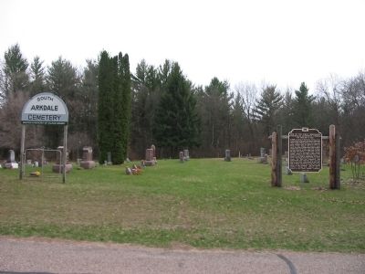
Learning and religion were of first concern. Freely giving to both, he labored unceasingly for a city whose good lay very close to his heart. — — Map (db m94062) HM
Native American canoes launched North America’s maritime legacy about 12,000 years ago, making them among the world’s oldest watercraft.
The origins of the birchbark canoe are told in the oral traditions of the Ojibwe people. The spirit . . . — — Map (db m57836) HM
Early Native American Inhabitants
People have been using and occupying sites in the Apostle Islands area for thousands of years. But it was probably not until after 800 A.D. that more extensive use of the islands took place in the form of . . . — — Map (db m165677) HM
The largest of the Apostle Islands was one of the earliest areas of Indian settlement, fur trade, missionary activity and commercial fishing in the interior of North America. It was discovered by French explorers in 1659. Trading posts were built . . . — — Map (db m234580) HM
The Mauvaise (Bad) River was so named by the French due to the difficulties of its navigation. The Indians called it Mushkeezeebi or Marsh River. In 1845 the Rev. L.H. Wheeler, Protestant missionary at La Pointe, planned an agricultural settlement . . . — — Map (db m63661) HM
1831 Henry Schoolcraft, Indian agent from Sault St. Marie, MI travels down the Red Cedar River to Rice Lake and held council with the Chippewa Indians at this approximate site. 1847 The Knapp Stout Co. purchased thousands of acres of . . . — — Map (db m161500) HM
You are standing at the “turning Point” for the Bayfield Waterfront Walk and across the water is a place of significance where “turning points” in history occurred. Madeline Island, or “Mooningwanekaaning Minis,” . . . — — Map (db m98243) HM
Bayfield’s history has been powerfully shaped by its location. Situated on the shores of a deep, natural harbor, the city is sheltered from Lake Superior’s notorious storms by the outlying Apostle Islands. Lighthouses, shipwrecks, and a historic . . . — — Map (db m57835) HM
In the early days of Washburn, the waterfront was filled with saw mills. The A.A. Bigelow Mill (1887-1902), later to become the Hines Mill, was the largest of three major sawmills in Washburn. It rested on pilings that ran directly out from the . . . — — Map (db m122317) HM
This park, built to portray and preserve Wisconsin's beginnings, is located on a site that is itself a part of history. On this 40-acre site stood Camp Smith--a temporary location of Fort Howard--part of the pioneer settlement known as Shantytown, . . . — — Map (db m240687) HM
was appointed by President Monroe as a district judge for the northern and western Michigan Territory, which included what is now the state of Wisconsin. Doty set up the region's new court in an empty log building.
Three years later, . . . — — Map (db m43822) HM
This house of wattled construction is the oldest standing house, in Wisconsin, built in 1776 by fur-trader Joseph Roi, one of the first seven settlers of La Baye (Green Bay).
It was sold in 1805 to Jacques Porlier, another French-Canadian . . . — — Map (db m240688) HM
Fort Howard commander Colonel Joseph Smith moved the garrison to near this location, about a half-mile back from the shore. The high ridge on which the camp,
dubbed “Camp Smith,” was located provided good visibility and protection . . . — — Map (db m43820) HM
The rapids at De Pere were well known to all early travelers along the Fox and Wisconsin rivers, which provided the best access to the Mississippi. Despite Indian domination, the waterway served explorers, fur traders and voyageurs, missionaries, . . . — — Map (db m11053) HM
In 1848, immigrants from Langeland, Denmark, seeking economic opportunity and plentiful farmland, settled in this vicinity. The Danes purchased land here and called their early settlement "Copenhagen," later changed to Denmark. In subsequent years, . . . — — Map (db m222658) HM
of the Morgan L. Martin family for 100 years (1837-1937). Martin was a prominent Green Bay attorney, civic leader, Indian agent and entrepreneur, originally from upstate New York, who helped lay the foundation for Wisconsin's statehood. In 1848, . . . — — Map (db m37204) HM
On this site Morgan L. Martin (1805-87) built this home in 1837, after his marriage to Elizabeth Smith of Plattsburgh, N.Y. It was a center of social, literary and political accomplishment for nearly a century. Coming here in 1827 as a young . . . — — Map (db m37202) HM
to many people for thousands of years before the first Europeans arrived. The rich waters of the bay attracted a number of American Indian Tribes - all members of a large and complex trading network stretching throughout North America.
Green . . . — — Map (db m43813) HM
This site is part of a 4800-acre tract patented to Eleazer Williams by the United States. In 1882 Williams led a delegation of New York Indians to the Fox River Valley, hoping to set up an Indian Empire in the West. A year later he married the . . . — — Map (db m57219) HM
This house was built by two early founders of Wrightstown - Hoel S. Wright and Carl G. Mueller. Wright and his wife, Orilla, founded the settlement when they moved here in 1833 from Pawlett, Vermont. Wright operated a trading post, ran a ferry . . . — — Map (db m125734) HM
Thomas A. Holmes (1804-1888) established the first permanent settlement in Buffalo County in 1839 at the present site of Fountain City. In the fall of that year Holmes and a party of twelve including his wife came up the Mississippi River to barter . . . — — Map (db m43205) HM
Before the white man came to this area Indians of the Chippewa, Winnebago and other tribes roamed freely along the Mississippi River. Recorded history tells of an Indian tribal battle that took place on these river banks which was witnessed by some . . . — — Map (db m43206) HM
Canute Anderson was born Canute Ingverson Eggum in Laerdal, Norway. He arrived in the Grantsburg area in 1854, establishing a stopping place and trading post where the buildings southeast of this marker stand. Opening the first post office in his . . . — — Map (db m68715) HM
The Brothertown (Brotherton) are descendants of the Pequot and Mohegan (Algonquin-speaking) tribes in southern New England. They became a tribe in 1769 when seven Christian and English-speaking communities organized and moved to land in upstate New . . . — — Map (db m31792) HM
"If I cannot be the citizen of free Germany,
then I would at least be a citizen of free America"
--Carl Schurz, German Revolutionary Leader, 1848
In 1848, a small group of immigrants from the Schleswig-Holstein area of . . . — — Map (db m46184) HM
Edson Union Cemetery was dedicated in 1887 by Maria and Edson Chubb, as a memorial to their only child Joseph. Buried here are Civil War veterans, victims of the 1880 diphtheria epidemic, and soldiers of the Spanish and American War.
Edson . . . — — Map (db m42597) HM
In 1865, Robert Marriner settled in this vicinity, built a dam and sawmill below the present Main Street Bridge an subsequently platted the village of Cadott.
The falls of the river here had been called “Cadotte Falls” for a member of . . . — — Map (db m120393) HM
In 1787, Michel Cadotte, famous Madeline Island fur trader, had a trading post nearby on the Yellow River. Here Michel Jr. was born, and another son, Jean Baptiste, is said to be buried on the river's bank. Robert Marriner built a dam at "Cadotte . . . — — Map (db m31159) HM
Among the fur traders who attained prominence in the Lake Superior region were Jean Baptiste Cadotte (Cadeau) and his sons, Jean Baptiste, Jr., and Michel.
Each married daughters of prominent Ojibway Indians; became influential as merchants, . . . — — Map (db m120429) HM
This statue is a conception of the “Cadotte” fur trader. Sculptor Jerry Holter of Clam Lake, Wisconsin, was commissioned to carve the figure from a solid section of native Northern White Pine, symbolic of the great lumbering industry of . . . — — Map (db m120392) HM
Hiram S. Allen was born in Chelsea, Vermont and came to the Chippewa Valley of Wisconsin in 1834. Here he began a long and flourishing career and an active business life. He built the first grist-mill, the first flour-mill, and the first hotel . . . — — Map (db m42343) HM
The building to your right is the oldest commercial building in Chippewa Falls. It was built (Circa 1859) by Peter Morie (Morey) and was used originally as a Saloon and Boarding House for lumberjacks and others. In 1861 at the start of the Civil . . . — — Map (db m55299) HM
This Columbia Street site was the location of the ornate pioneer mansion built by Hiram Stores Allen. Called the founder of Chippewa Falls, Hiram built the first grist-mill, the first flour-mill, and the first hotel in Chippewa Falls. He operated . . . — — Map (db m38891) HM
Built in 1871 by Alexander Wiley Sr. and Nels Elikson, the rooming house over the years was home for hundreds of immigrants, lumber jacks, mill workers, farm hands and log drivers (known as river pigs). In 1887 Wiley Sr. became the sole owner and . . . — — Map (db m42697) HM
William Irvine was born in Mount Carroll, Illinois of Scotch-Irish ancestry. He came to the Chippewa Valley when he was 14 years old to work for his brother-in-law, who was captain of a raft boat towing lumber from Chippewa Falls to Mississippi . . . — — Map (db m38788) HM
This tablet was erected in 1931
by The Women's Club of
Cornell, Wisconsin
and serves a twofold purpose.
—
On the hillside below, unmarked and obliterated, are many Indian graves of days long past. At a later period this plot . . . — — Map (db m46047) HM
Ezra Cornell was the man who founded the City of Cornell, Wisconsin, but actually never lived here. Cornell was born in 1807 in New York State of Quaker parents. He was a farmer, inventor, businessman, statesman, and a philanthropist. He . . . — — Map (db m46026) HM
Jean Brunet is one of the most noteworthy pioneers of the Chippewa Valley. Born in France in 1791, Brunet immigrated to this country in 1818 and moved to Chippewa Falls in 1828. He built the first dams on the Chippewa River at Chippewa . . . — — Map (db m46018) HM
The present Village of New Auburn approximates the site of Cartwright Mill, founded in 1875 by David J. and Paul W. Cartwright. To the original sawmill, powered by steam, they added a lath, shingle, and planing mill. Some buildings were of brick . . . — — Map (db m45182) HM
In 1847, a German by the name of George Myers arrived in Chippewa Falls looking for a tract of land for farming purposes. Prior to that time no one had attempted to cultivate any larger spot of ground than a garden patch. He chose this tract of . . . — — Map (db m55590) HM
In the early 1850's, settlers from Rhine, Bavaria, Bohemia, and Luxembourg came to this part of Wisconsin now known as Tilden Township. They vowed to build a church in honor of the "Blessed Virgin Mother of God" giving thanks for their safe voyage . . . — — Map (db m55397) HM
The Mormons, Clark County's first loggers, came in 1844 and established camps between Wedge's Creek and Greenwood to cut timber for their Illinois city of Nauvoo. After the murder of their leader Joseph Smith at Carthage, Illinois in mid-1844, the . . . — — Map (db m103977) HM
Side A Neillsville has strong ties to the majestic white pine forests of the Wisconsin Territory. These forests along the Black River and its tributaries drew members of the Church of Jesus Christ of Latter-day Saints in 1841. Remembered . . . — — Map (db m185567) HM
St. Hedwig's
In 1891, a wooden church was built and named St. Hedwig's for a queen of Poland. In 1904, the present-day structure was built and accommodated the growing congregation with seating for 700 people. Members of the congregation . . . — — Map (db m48771) HM
On this site in 1844, John Langdon & his four sons erected a sawmill, a dam & gristmill. Other early settlers by the names of McConochie, Dodge, Torbert, & Williams joined in construction. The original place name of Langdon's Mill, later became . . . — — Map (db m66352) HM
Governor James Taylor Lewis · 1819 – 1904
Governor James T. Lewis, the ninth Governor of Wisconsin (1864-66), led the state through the tumultuous conclusion of the Civil War. He was born in New York State and in 1845 settled in . . . — — Map (db m22918) HM
At this location, in 1846, Alfred A. Brayton constructed a log and earth dam across the Crawfish River and erected a saw mill.From this saw mill the village of Fall River was built. — — Map (db m150747) HM
A congregation of German settlers had been worshipping in a log cabin about 200 feet north of this sign, on property homesteaded by James Inglehart in 1846.
In 1867 the congregation decided to build a church.
James Inglehart offered this . . . — — Map (db m74235) HM
The Palmer Tree, a stately burr oak was a mere acorn in front of the Palmer Family log cabin, when Lodi was settled in 1848. Its testimony to a peaceful community continues, as it stands proudly to welcome all who enter the Lodi Valley Historical . . . — — Map (db m33882) HM
Merrimac’s first permanent settler, Chester Mattson, obtained a territorial charter in 1848 to provide ferry service across the Wisconsin River. The State Legislature of 1851 authorized a road, subsequently to become State Trunk Highway 113, to . . . — — Map (db m1932) HM
Historic Pardeeville
In 1848, New York native and Milwaukee merchant, John S. Pardee hired agents to oversee his Fox River land holdings and to establish business operations from this location. Yates Ashley, the most notable of Pardee's . . . — — Map (db m215748) HM
In the autumn of 1828 a permanent fort was built on this site by the First Regiment of the United States Infantry under the command of Maj. David E. Twiggs, later a general in the Confederate Army. The fort was constructed primarily to control the . . . — — Map (db m2364) HM
The Indian Agency House was built in 1832 by the United States Government for John Harris Kinzie and his wife Juliette Magill Kinzie. John Kinzie was the Indian Agent to the Ho-Chunk (Winnebago) Indians. He had been assigned by the Government to . . . — — Map (db m230836) HM
Landing place of the ferry built by Pierre Pauquette and operated by him from about 1828 until his death in 1836. This ferry was in use until the first bridge was built across the Wisconsin River in 1857. — — Map (db m74344) HM
Near here in 1849 Thomas Twiggs began a settlement of unemployed potters from Staffordshire, England. To help farmers on both sides of the Fox River reach his store and blacksmith shop at Twiggs' Landing, he operated Emancipation Ferry, named to . . . — — Map (db m20084) HM
This home, constructed for Indian sub-agent John H. Kinzie, served as an embassy between the Federal Government and the Hoocak (Ho-Chunk, Winnebago) Nation during a turbulent period of cultural convergence and the initiation of the Hoocak Trail . . . — — Map (db m230837) HM
Before the introduction of the railroad, the Wisconsin River
provided one of the most practical means of transporting lumber
and farm products to distant markets. The old Village of Dekorra was
beautifully situated to take advantage of this . . . — — Map (db m165534) HM
Wallis/Wallace Rowan (1800-1847) was born in Kentucky of Scotch Irish descent. He was a lead miner, trader, innkeeper, land speculator, farmer, and mill owner. In 1818 he married Elizabeth “Betsy” Metcalf in Illinois. By 1828 Rowan was . . . — — Map (db m67233) HM
A Wisconsin Pioneer
One of the founders of Wisconsin Dells, Joseph Bailey completed the first dam across the Wisconsin River here in 1859. Opposition from upriver lumbermen required the dam's removal in 1860. Bailey's dream to build an . . . — — Map (db m134610) HM
The first bridge on this site, a wooden structure, was completed in 1857. Byron Kilbourn, land speculator and politician promoted the site. Through his influence the LaCrosse and Milwaukee Railroad crossed the river here instead of at Newport, 2 . . . — — Map (db m8047) HM
Downriver sits the ruins of the lost city of Newport. In the early 1850s, the settlement on the Lower Dells developed rapidly, amidst rumors the town was to be the spot of the new LaCrosse and Milwaukee Railroad bridge. Speculators' hopes were . . . — — Map (db m157129) HM
Perry G. Stroud, a young attorney from New York, established this early bank in Kilbourn City, now Wisconsin Dells, in ca. 1870. Over his thirty-year career as the town's first attorney, Stroud preserved much of the city's early documentary history. . . . — — Map (db m7850) HM
Major Dickason
Major Elbert Dickason founded Wyocena in 1843. He platted and named the village in 1846. He was instrumental in Wyocena being temporarily named the county seat. He died in 1848 and is buried in the Wyocena Cemetery.
Erhardt . . . — — Map (db m37115) HM
Major Elbert Dickason
Major Elbert Dickason founder of Wyocena, was born in Virginia in 1799. He moved to Illinois where he joined their militia during the Black Hawk War. Representing a Milwaukee land investor, he founded Columbus in 1839. . . . — — Map (db m22839) HM
In the year 1847 James B. Gay, a civil engineer and native of Indiana, journeyed to the unsettled Kickapoo Valley. Here he was impressed by acres of untouched forest which covered the hills and valleys. Finding a good rock bottom in the river and . . . — — Map (db m40057) HM
In prehistoric times water from melting glaciers cut a wide valley between the bluffs of the Mississippi River to form a broad flood plain. On it French explorers, traders and missionaries found a large and well-established Fox Indian village. The . . . — — Map (db m43529) HM
This hilltop mansion commands a sweeping view of a landscape steeped in history. Descendants of pioneer fur trader Hercules Dousman built the house in 1870 atop a mound overlooking the Mississippi River, which drew European explores to this spot in . . . — — Map (db m23586) HM
Product of a small American community, James O. Davidson's life illustrates the romance of citizenship in a democracy. Born 1854 in Norway, where he received little formal education, he emigrated in 1872 and was a farmer and tailor before coming in . . . — — Map (db m31671) HM
In late July, during the Black Hawk War of 1832, Sac Indian leader Black Hawk led his starving followers through this area in their escape from the General Henry Atkinson and his military forces. After Black Hawk's brilliant delaying tactics at the . . . — — Map (db m31659) HM
(side 1)
Early Belleville
Finding a mill site on the Sugar River, founder John Frederick settled here in 1845. His mill prompted "Yankee" settlement and a village developed with a hotel/tavern, blacksmith, harness maker and general . . . — — Map (db m59539) HM
Final resting place of early French emigrants and their descendants. Coming directly to the Montrose-Belleville community from St. Germain in eastern France, 32 families arrived beginning in the early 1850's. Unique and isolated, the group . . . — — Map (db m37296) HM
This once clear tributary to the Wisconsin River now carries tons of soil from croplands on ridges and slopes. Silver maples, willows and box elders grow on the soil deposited by erosion. The low peaty meadows on both sides of the creek serve as a . . . — — Map (db m36987) HM
The onset of the Black Hawk War in northwestern Illinois in April, 1832 triggered panic in southwestern Wisconsin's lead mining region, prompting erection of over a dozen stockades. On an open prairie knoll 3/4 mile south of this marker, area miners . . . — — Map (db m35412) HM
Ebenezer Brigham (1789-1861), first permanent white settler of Dane County, came here as a prospector in 1828. The inn he built for his miners became popular with travelers on the old Military Road, and Blue Mounds became a well-known landmark. . . . — — Map (db m224706) HM
This corner has a colorful background as the site of a saw mill, grist mill, post office, grocery store, hotel, blacksmith shop, dance hall and until 1958 the Town Hall. In 1847 Samuel Lattimer built a saw mill that operated until 1865 when it was . . . — — Map (db m55592) HM
German immigrant families from Hesse began settling in this area of Blue Mounds Township in the 1840s. As early as 1856, Lutheran missionaries conducted home services for the rural community. In 1867, on acreage purchased from Justus Heuser, a frame . . . — — Map (db m75828) HM
Built in May 1832 by the miners and settlers of the neighborhood and garrisoned by them as volunteer members of General Henry Dodge's Iowa-Michigan Brigade from May 20 to September 20, 1832 during the Black Hawk War
This site was donated . . . — — Map (db m36980) HM
Koshkonong Prairie with its twin churches at both East and West Koshkonong is one of the focal points from which Norwegian Lutheranism spread to many parts of the American continent.
In 1844 at the request of pioneer Norwegian immigrants . . . — — Map (db m36145) HM
In 1838 at the foot of this bluff Berry Haney, a migrant from Cross Plains, Tennessee, established the Cross Plains Post Office in a log house. Early Cross Plains was the site of important military road crossings and Haney became the pioneer . . . — — Map (db m32617) HM
The Matz Farmhouse, approx. 1907 [photo] You are standing in front of the stone remnants of the Matz farmhouse. The land was first homesteaded in 1852. Friedrich describes the initial living quarters as, “An American farmer isn’t set . . . — — Map (db m108764) HM
Early Norse pioneers who realized a need for a house of worship built the first Norwegian Lutheran Church in western Dane County from logs in the winter of 1851-52. First services held May 27, 1852 by the Rev. A.C. Preus. Previous itinerant pastors . . . — — Map (db m36718) HM
In July, 1833, Lt. Alexander Center blazed a nearby oak, marking the 100-mile point of a military road he and James Doty were surveying. The Old Military Road, built from 1835 to 1837, connected Ft. Crawford at Prairie du Chien, Ft. Winnebago at . . . — — Map (db m36907) HM
The Village of De Forest and the surrounding 2200 acres were once owned by Isaac N. De Forest. He purchased the site for $25.00 an acre in 1854 to farm and raise wheat. In 1856, before moving to Wetmore, Kansas, he started platting the site for a . . . — — Map (db m37568) HM
In the 1850's, the U.S. government commissioned a well to be dug on this site to insure the settlers of a pure source of water. The well was seventy feet deep and cased in hand-laid stone. It served the community for many years after the Karows . . . — — Map (db m38091) HM
Originally at the NW corner of Fish Hatchery and Lacy Roads, the Dogtown School was later relocated ½ mile north and called the Fish Hatchery School. The Gorman Family relocated and restored the one room schoolhouse on this site in 1989. — — Map (db m26762) HM
Originally at the NW corner of Fish Hatchery and Lacy Roads, the Dogtown School was later relocated ½ mile north and called the Fish Hatchery School. In 1919 a new building was built at the original site. This building burned in 1937. A third . . . — — Map (db m26765) HM
Illinois Central Depot side
On this site a two-story railroad depot stood from 1888 to 1939. The depot served the Illinois Central Railroad, which provided passenger and freight service to Fitchburg on its route from Freeport, Illinois to . . . — — Map (db m120014) HM
This elegant Italian villa style house was constructed of native sandstone on the 191-acre country estate of Simeon and Maria Mills. An early pioneer from Ohio, Mills erected Madison's first store and was a banker, real estate developer and . . . — — Map (db m41983) HM
Madison changed with great speed in the 1830s: from Ho-Chunk home to war zone to capital city. Powerful forces were gathering against the Ho-Chunks. To gain more land, southwest Wisconsin lead miners pressured the U.S. government to remove the . . . — — Map (db m35314) HM
Even before Madison was founded, people met to exchange money and merchandise not far from this spot. Five hundred Ho-Chunk camped near the square in 1832 to swap furs for trader Oliver Armel’s goods. People began building businesses on Capitol . . . — — Map (db m33482) HM
This quaint stone carriage house was built for James and Minnie Corry. Corry, a well-known realtor, helped develop the Fair Oaks plat and was a promoter of the east side. The Corrys' plans to build a house in front of the carriage house were halted . . . — — Map (db m45442) HM
Marker Front:
Dean House
This simple flat-roofed cream brick structure with wood cornice and dentils was built by the Dean family as their country home. After 1871, the home was used by tenant farmers and in the 1920's as the Monona . . . — — Map (db m144039) HM
The land surrounding this spot was originally the farm of George and Mary Drohman, pioneer German settlers who came to the U.S. around 1846. From 1851 to 1906 another German-American family, Adolph and Mary Sigglekow and their two sons, tilled this . . . — — Map (db m45337) HM
Once a marshy area off the shores of Lake Monona, this triangular shaped neighborhood became a dream for Italian immigrants during the early 1900's. Greenbush developed into one of America's countless Little Italys, complemented with Jewish, Black . . . — — Map (db m32636) HM
Herman Loftsgordon and his family lived in this house from 1918 until 1946. Loftsgordon was one of five brothers who came to Madison from Mt. Horeb in the early 1900's and settled within blocks of each other in the Elmside plat. The family was . . . — — Map (db m41523) HM
600 entries matched your criteria. The first 100 are listed above. Next 100 ⊳