Near Old Post Road, 0.4 miles south of State Route 169.
A bitter winter rain had turned the ground to mud. But the Confederate
soldiers had to keep digging. These rifle pits, lying just a few feet from where
you stand, were far from finished. Though exhausted and hungry, the soldiers
were ordered to . . . — — Map (db m107874) HM
Near Old Post Road, 0.5 miles south of State Route 169.
The Confederate scouts were alarmed. Looking down river to your right, one exclaimed, "One could hardly see anything in the background but smokestacks."
Union soldiers disembarked from their transports. All night, knee deep in mud, they . . . — — Map (db m108509) HM
On Old Post Road, 0.5 miles south of State Route 169, on the left when traveling south.
You wouldn't have got us had it not been for your damned gunboats.
John Dunnington, colonel, chief of ordnance
Fort Hindman's cannon fired at the nine gunboats
bearing down on them. Confederate gunners had . . . — — Map (db m108072) HM
Near Old Post Road, 0.4 miles south of State Route 169.
Half the Yankees in the West [were coming].
Confederate scout
I expected Mary would be a widow before I got 10 rods [55 yards]. . . . — — Map (db m107858) HM
Near Old Post Road, 0.8 miles south of State Route 169.
In the early 1800's the land in front of you was an important
center of trade and government on the edge of the Arkansas River
wilderness. Here were the homes, stores, taverns, mills,
docks, and busy streets of the Post of Arkansas. This . . . — — Map (db m108428) HM
Near Old Post Road, 0.8 miles south of State Route 169.
Arkansas Post was not a single fort and trading center. From
1686 until 1863 there were no fewer than seven posts on the
Arkansas River between here and the Missişsippi. The flags
of five nations flew over them.
The 1686 post . . . — — Map (db m108464) HM
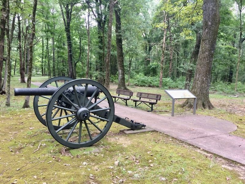
Near Old Post Road, 0.5 miles south of State Route 169.
Standing here in January 1863, you would have seen
Confederate Fort Hindman. In what is now the water, the
fort stood atop a 25-foot high bluff The fort's cannon could
fire a mile up or down the river to protect the breadbasket
of Arkansas. The . . . — — Map (db m108511) HM
On Arkansas Route 153, 1 mile north of Arkansas Route 1, on the left when traveling north.
On this site from September 1862 to January 1863 was the encampment of a celebrated Texas cavalry company. Captain Alf Johnson's Spy company was active in conducting reconnaissance and small unit actions near Helena while maintaining vigilance on . . . — — Map (db m107804) HM
On Arkansas Route 153 north of Starks Lane, on the right when traveling north. Reported permanently removed.
Named for Captain Robert Crockett, grandson of the famous David (Davey) Crockett, this community was a flourishing river port during the second half of the 19th century. The Crockett Rifles (Company H, 1st Arkansas Infantry), first Confederate . . . — — Map (db m107807) HM
On U.S. 165 at State Route 169, on the right when traveling north on U.S. 165.
On January 9, 1863, Gen. John McClernand and Adm. David D. Porter led a 30,000 man army and a flotilla of Union gunboats up the Arkansas River to confront Gen. T.J. Churchill's 5,000 Confederates at Arkansas Post. The gunboats bombarded Fort Hindman . . . — — Map (db m107701) HM
On Belnap Avenue at NCC Camp Road, on the right when traveling east on Belnap Avenue.
Here on June 17, 1862 a Federal fleet of eight vessels attempted to force its way upstream past Confederate shore defenses commanded by Captain Joseph Fry. The Confederates disabled the Union gunboat Mound City with heavy casualties before . . . — — Map (db m107918) HM
On West Broadway Avenue at Arkansas Street, in the median on West Broadway Avenue.
[Northeast face]
Officers and men killed on
the U.S.S. Mound City
{List of 124 dead}
[Northwest face]
Near this spot, on June 17, 1862,
a decisive engagement was
fought between the Conf-
ederates entrenched and
the . . . — — Map (db m108071) WM
On North Buerkle Street (U.S. 63/165) just north of Madison Street, on the left when traveling north.
In August and September, 1862, General Mosby M. Parsons
and 800 men of the Missouri State Guard encamped here,
after a perilous crossing of the Mississippi River into Desha
County. This small force of infantry and artillery blocked
enemy . . . — — Map (db m167369) HM
On East Jefferson Street east of North Oak Street, on the left when traveling east.
Ashley County in the Civil War
Thirteen companies were raised and organized in Ashley County for Confederate service during the Civil War: Co. F, 2nd Arkansas Cavalry; Cos. A, B, K and L, 3rd Arkansas Infantry; Co. F, 8th Arkansas Infantry . . . — — Map (db m107691) HM
On South Main Street (Business U.S. 62) at East 7th Street, on the right when traveling north on South Main Street.
On Oct. 12, 1862, Maj. John Wilber led a force of 125 men of the 14th Missouri State Militia (U.S.) and 100 from the Enrolled Militia from Ozark, Mo., to hit Confederate troops camped at Yellville. High water on the White River forced the Union . . . — — Map (db m170457) HM
On N. Old Wire Road (County Road 1703) 0.4 miles north of Smith Ridge Turnoff, on the left when traveling north.
Here on February 17, 1862, Brig. Gen. Rains with the Fourth Arkansas Regiment and the Third Louisiana, ambushed the advance of the Federal army under Brig. Gen. Curtis killing 20 of his men and some 60 horses in his advancing cavalry. The . . . — — Map (db m99707) HM
On Hudson Road (U.S. 62) south of Rose Street, on the right when traveling north.
800 AD • Trace of the Rock People
1808 • Osage Boundary
1815 • Lawrence County
1827-28 • Lovely County
1838 • Trail of Tears
1840 • Trott's Stand
1858 • Old Wire Road
1858-61 • Butterfield Stage Route
1861 • Troop Trails
1862 • . . . — — Map (db m62485) HM
The Medal of Honor is the highest Military decoration awarded by the United States. It is bestowed on a member of the American Armed Forces, who distinguishes himself or herself conspicuously by gallantry and intrepidity at the risk of his life . . . — — Map (db m90869) HM WM
The immediate cause of the War Between the States was the election of Abraham Lincoln to the Presidency of the United States in 1860. The deeper cause, however, was the issue of states' rights. The question of states' rights was based on the . . . — — Map (db m91678) HM
[Written on the initial marker, provided for context]
Our Constitution names the President of the United States the Commander in Chief of all the Armed Forces. Presidents who have served in our military are displayed on the following . . . — — Map (db m92389) HM WM
[Written on the initial marker, provided for context]
Our Constitution names the President of the United States the Commander in Chief of all the Armed Forces. Presidents who have served in our military are displayed on the following . . . — — Map (db m92400) HM WM
On Arkansas Route 72 at Sugar Creek Road, on the right when traveling north on State Route 72.
Named for Alexander H. Stephens, vice-president of the Confederacy, it covered land on Little Sugar and Brush Creeks extending eastward three miles from their confluence at this point.
Brig. Gen. Nicholas Bart Pearce established it in July, 1861 . . . — — Map (db m225100) HM
Near South Walton Boulevard (Business U.S. 71) 0.1 miles north of Southwest I Street, on the left when traveling north.
Col. Samuel W. Peel House
Built 1876
has been placed on the
National Register
of Historic Places
by the United States
Department of the Interior
— — Map (db m167937) HM
On West Central Avenue at North Main Street, on the left when traveling east on West Central Avenue. Reported permanently removed.
All 4 sides
Confederate
Side 1
To the Southern Soldiers
Side 2
Their names are borne on honor's shield.
Their record is with God.
Side 3
They fought for home and fatherland.
Side . . . — — Map (db m21242) HM
On SW A Street at West Central Avenue, on the right when traveling north on SW A Street.
On the morning of March 6, 1862, Gen. Franz Sigel was eating his breakfast at the Eagle Hotel which stood on this site. He had remained here with 600 men and a battery of six pieces after the main column of his army had passed through Bentonville on . . . — — Map (db m22447) HM
On Southeast 2nd Street at Southeast B Street, on the right when traveling east on Southeast 2nd Street.
Built in 1890 by Capt. NH Henry
Captain Henry served in the Civil War as a member of General Stonewall Jackson's artillery. After the war Henry moved to Bentonville where he helped build Bentonville's first steam railway and served as a . . . — — Map (db m225133) HM
On Military Park Road (County Road 65), on the right when traveling south.
I saw General Sigel sight one piece...and send a shot at the [rebel] guns that had driven us back...It went tearing in among the men and horses, killing and wounding both, and then exploded in one of the caissons...Placing his glass to his eye . . . — — Map (db m35684) HM
On Military Park Road (County Road 65), on the left when traveling north.
We must not let the men know that General McCulloch is killed. Benjamin Pixley, Lieutenant, 16th Arkansas Infantry The general in charge of this half of the Confederate army - Texan Ben McCulloch - had formed his division, some 7,000 . . . — — Map (db m35559) HM
On Military Park Road (County Road 65), on the right when traveling north.
...this battle...was a mass of mixed up confusion from beginning to end...Would to God it was night or reinforcements would come. William Watson, sergeant, 3rd Louisiana Infantry Regiment Four regiments of volunteers from Arkansas and . . . — — Map (db m35566) HM
On Military Park Road (County Road 65), on the right when traveling east.
I don't believe they ever made a harder march during the Revolution than we made that night. Jack Bower, private, 2nd Missouri Regiment The 16,000-strong Confederate Army of the West spent most of the first week of March 1862 trudging on . . . — — Map (db m35614) HM
On Military Park Road (County Road 65), on the right when traveling south.
…[the Yankees] opened a perfect storm of round and shrapnell shot and shell…[the ground] was literally ploughed up by cannon ball…It is a perfect miracle that any of us ever came out. John J. Good, captain, Dallas Texas Light Artillery, . . . — — Map (db m35672) HM
On Military Park Road (County Road 65), on the right when traveling south.
(Front):ANGEL ALOFTSpirit of eternal light, Keep silent vigil o'er the brave; The untarnished blue, The unsullied gray, In peace and love unite. Proud heroes have fallen, And over their grave, Our hearts are united, Our country to save. . . . — — Map (db m242714) HM
On Military Park Road (County Road 65), on the left when traveling west.
Entering a little clearing, we discovered the yellow hospital flags fluttering from the gables of every house in the hamlet of Leetown, and the surgeons busy with the sad, yet humane task that was theirs to perform. Lyman G. Bennett, . . . — — Map (db m35503) HM
On Military Park Road (County Road 65), on the right when traveling west.
In early March 1862, these now quiet fields bustled with the clamor and constant motion of an army headquarters in time of battle. Soldiers drilled, cleaned guns, and checked ammunition. Scouts and couriers rode in to report. Officers convened for . . . — — Map (db m35476) HM
On Military Park Road (County Road 65), on the left when traveling south.
As the sun set on the first day of battle, about 3,000 rebels from Missouri made their final charge here. Crossing Ben Ruddick's stubbled cornfield, they ran straight toward the muzzles of Federal cannon set wheel hub to wheel hub against a line . . . — — Map (db m35671) HM
Near Military Park Road (County Road 65), on the left when traveling south.
It took two weeks for the stunned survivors of the Confederate Army of the West to make their way from here back to rendezvous on the Arkansas River. In late March 1862 General Van Dorn was ordered to take his army east to Mississippi. This left . . . — — Map (db m35666) HM
Near Military Park Road (County Road 65), on the left when traveling south.
Confederate commander Earl Van Dorn had pushed his army relentlessly for a week to catch the Union army by surprise. Now, after hours of hard fighting up the Telegraph Road, here in sight of Elkhorn Tavern, Van Dorn gambled by committing all his . . . — — Map (db m37756) HM
Near Military Park Road (County Road 65), on the right when traveling south.
The first day's fighting ended at sunset on the large open field you see in the distance below. The half of the Confederate army that had circled completely around Big Mountain - where you now stand - had fought hard all day to force their way up . . . — — Map (db m35616) HM
On Military Park Road (County Road 65), on the right when traveling west.
General Samuel Curtis had only 10,500 troops to hold back a Confederate army of more than 16,000 men moving toward him. Curtis had asked army headquarters in St. Louis for reinforcements. None could be sent. At the last minute, Union soldiers dug . . . — — Map (db m35496) HM
Near Military Park Road (County Road 65), on the right when traveling south.
The families who lived outside Leetown, Arkansas first heard shots fired on the far side of Little Mountain, the low wooded rise you see to the right. Half of the Confederate Army of the West was marching eastward on Ford Road, moving this way. . . . — — Map (db m35639) HM
Near Military Park Road (County Road 65), on the right when traveling south.
It was extremely rare in the Civil War to be able to see an entire army lined up for a fight, with all the regiments within sight of each other. Had you stood here on Saturday, March 8, 1862, you could have see 10,000 Union men in battle lines . . . — — Map (db m35622) HM
Near Military Park Road (County Road 65), on the left when traveling west.
The small hamlet near here included two stores, a blacksmith shop, Masonic hall, church, school and several residences. During the fighting some of the buildings were used by the Union Army as hospitals. — — Map (db m35505) HM
On Military Park Road (County Road 65), on the left when traveling south.
Elkhorn Tavern overlooks a highway of vital importance for Arkansas and Missouri during the Civil War. Union and Confederate leaders both wanted this 20-foot-wide dirt road to move men and supplies. Alongside the road ran 3-year-old telegraph . . . — — Map (db m35660) HM
Near Military Park Road (County Road 65), on the right when traveling south.
I have ordered Generals Sigel and Davis to move with their divisions during the night and form on the left of Carr's division ... and be ready to renew the battle at daylight. The enemy will concentrate his whole force at Elk Horn; we will . . . — — Map (db m35619) HM
On Military Park Road (County Road 65), on the right when traveling south.
(Front):THE BRAVE CONFEDERATE DEAD, WHO FELL ON THIS FIELD, Mar. 6, 7, & 8, 1862.The graves of our dead with the grass overgrown, May yet form the footstool of Liberty's throne; And each single wreck in the war-path of Might, Shall yet be . . . — — Map (db m242713) WM
On N. Old Wire Road (County Road 67) 1.5 miles north of Gann Ridge Road, on the right when traveling north.
On the Arkansas—Missouri line where the Telegraph Road entered ten-mile long Cross Timber Hollow, on February 16, 1862, occurred the first skirmish on Benton County soil. Brig. Gen. Curtis’ Federal army overtook the rear guard of Maj. Gen. . . . — — Map (db m99705) HM
On Military Park Road (County Road 65), on the right when traveling south.
The two stone monuments you see here reflect the long-lasting grief - and the hopes - of the generation of Americans who survived the Civil War. After the war, young men whose lives had been forever changed by this battle began returning to these . . . — — Map (db m35642) HM
On Military Park Road (County Road 65), on the left when traveling north.
Like maddened hornets, Confederate infantrymen boiled out of Morgan's Woods, crossed Leetown Road, and swarmed toward the six Federal cannon that had unlimbered in this corner of Oberson's cornfield. Captain William Black stood in front of the . . . — — Map (db m35562) HM
Near Military Park Road (County Road 65), on the right when traveling south.
Below you here stand 30-foot-tall columns of stone. Bone-tired Confederates of the 2nd Missouri Brigade took shelter amid these rocky dens after the first day's hard marching and fighting. What at first seemed like a good natural defense became a . . . — — Map (db m35638) HM
On Military Park Road (County Road 65), on the right when traveling north.
Officers and men, you have it in your power to make or prevent another Bull Run affair. I want every man to stand to his post! Nicholas Greusel, colonel, 36th Illinois Infantry Regiment Yankee cavalrymen, mauled from a sharp fight with . . . — — Map (db m35591) HM
On Military Park Road (County Road 65), on the right when traveling south.
That beautiful charge I shall never forget; with banners streaming, with drums beating, and our long line of blue coats advancing upon the double quick, with their deadly bayonets gleaming in the sunlight, and every man and officer . . . — — Map (db m35677) HM
On Military Park Road (County Road 65), on the right when traveling west.
It was still below freezing at 10:30 a.m. March 7, 1862, when an alarmed messenger thundered into Union headquarters. The news he carried was startling: Confederates were moving down the Telegraph Road a mile north of Elkhorn Tavern. All . . . — — Map (db m35459) HM
On Military Park Road (County Road 65), on the left when traveling north.
Imagine 7,000 Confederate troops crowded in close order along Ford Road, the lane you see on the right edge of this field. As they trudged east toward Elkhorn Tavern, a small Union force of Iowa cavalrymen - only 600 men - unexpectedly appeared . . . — — Map (db m37755) HM
This site was the camp-ground for commanding officers and headquarters of U.S. Army for Battle of Pea Ridge. Here councils of war were held. Camp for 10,500 soldiers. U.S. Army located 1 ½ miles south. Depot of supplies 1 mile north of this site. — — Map (db m35688) HM
Near Military Park Road (County Road 65), on the left when traveling south.
It was the fiery end of the best day of Earl Van Dorn's 20 years as a professional soldier. Bone-tired from the jarring of a week-long ambulance ride and still feverish from pneumonia, the Confederate commander lay down here in the side yard of . . . — — Map (db m35661) HM
On Sugar Creek Road (County Road 44), on the right when traveling east.
The high bluffs here on Little Sugar Creek were a scene of frantic activity on the morning of March 6, 1862 as Federal soldiers shoveled out rifle pits and cut down trees for hasty field fortifications. With no hope of reinforcements from St. . . . — — Map (db m35690) HM
On Pioneer Lane, 0.2 miles south of Mockingbird Lane, on the left when traveling south.
(South face)
To the
heroes
who fell or fought for
the land they loved during
the Civil War 1861-65.
Their sacrifices cemented
our union of states and made
our flag glorious forever.
On fame's eternal camping ground . . . — — Map (db m225024) WM
On Georgia Flat Road (County Road 503) at Kane Road (County Road 422), on the left when traveling west on Georgia Flat Road.
Camp Jackson Confederate Gen. Ben McCulloch established
Camp Jackson in July 1861 before marching into
Missouri. After the Aug. 11 Battle of Oak Hills
he returned to Camp Jackson. The 4th Arkansas
Infantry Regiment, which formed Aug. 17, . . . — — Map (db m224988) HM
Near Georgia Flat Road (County Road 503) south of Kane Road (County Road 422), on the left when traveling south.
Soldiers who died at Camp Jackson in 1861
and buried here in unmarked graves
Calhoun Escopets – Co. A
Adolphus P. Williams - Pvt. • Francis C. Harbor - Pvt. • Benjamin F. Bearden - Pvt. • James W. Strong - Pvt. • John C. Farmer - Pvt. • . . . — — Map (db m225001) WM
On Jackson Place north of McClure Avenue (County Road 923), on the left when traveling north.
The Old Wire Road at Mudtown was used by the
Butterfield Overland Mail Co. and both Union and
Confederate soldiers during the Civil War. In
February 1862, Union troops ate food left behind
at a Confederate camp and were sickened. Some
died, . . . — — Map (db m224817) HM
On Jackson Place at McClure Avenue (Route 923), on the left when traveling north on Jackson Place.
Mar. 20, 1839 Trail of Tears Mar. 8, 1847 Robinson's Crossroads First Post Office Feb. 5, 1858 Name changed to Bloomington Sept. 18, 1858 Butterfield Stage Stop to 1861 Dec. 9, 1862 Civil War Skirmishes Aug. 24, 1864 "Camp Mudtown" Mar. 9, 1881 . . . — — Map (db m33712) HM
On Primrose Road at Phillips Road, on the left when traveling south on Primrose Road.
James Miller Ingram was a captain in the Confederate 6th Provisional Cavalry Partisan Rangers. Years after the war ended, as a self-taught minister he went to preach at a church and was murdered - shot in the back by 19 year old John M. Stone. . . . — — Map (db m68790) HM
On Arkansas Route 72 at Busse Road, on the left when traveling north on State Route 72.
This camp was established in June, 1861, by Brig. Gen. Nicholas Bart Pierce, a Benton County man, to train recruits from Western Arkansas and the Indian Nation. He was a West Point graduate.
Many Arkansas units, Greer's Texas regiment, . . . — — Map (db m77950) HM
On State Highway 43 near State Highway 72, on the right when traveling south.
Occurred on Oct. 22, 1862. While Gen. James G. Blunt was encamped on the old Pea Ridge battlefield, word came that Gen. Douglas H. Cooper and Col. Stand Watie's Indian regiment were at old Fort Wayne across the line from Maysville. On Oct. 20 he . . . — — Map (db m52281) HM
On N. Curtis Avenue at E. Pickens Road, on the right when traveling north on N. Curtis Avenue.
Texas
Remembers the Valor and Devotion of
Her Sons Who Served at Elkhorn Tavern
(Pea Ridge), Arkansas
March 7-8, 1862
In Van Dorn’s attack of March 7, these Texas units under Brig. Gen. Ben McCulloch assaulted the Union right center:
. . . — — Map (db m99763) WM
On West New Hope Road at South Osage Springs Drive, on the right when traveling west on West New Hope Road.
Shortly after the Union Army of the Southwest entered Arkansas in February 1862, three divisions moved to Osage Springs in a bid to trap Confederate troops in their winter quarters. The trap failed, but the soldiers established Camp Halleck, . . . — — Map (db m224877) HM
On South Old Wire Road (County Road 83) 0.2 miles north of Dogwood Drive/Cross Hollow Road (County Road 1189), on the left when traveling north.
This post office was established in 1843. Nov. 29, 1861, Gen. Ben McCulloch moved his army into winter quarters here. Numerous, large, two-room, plank barracks were built in two rows facing each other, extending eastward more than a mile. Ten or . . . — — Map (db m68788) HM
On South Old Wire Road (County Road 83) 0.2 miles north of Dogwood Drive/Cross Hollows Road (County Road 1189), on the left when traveling north.
This site was donated to the Benton County Historical Society by Scarlett Biggs Wilson and Lara Wilson Rosenblum in honor of their parents/grandparents, Guy and Nell Biggs, early pioneers of the Cross Hollows area. Cross Hollows is recognized for . . . — — Map (db m68789) HM
On State Highway 12, 0.1 miles west of Van Winkle Place Road, on the left when traveling west.
Peter Van Winkle’s saw mill cut lumber for Confederate soldiers’ winter quarters at Cross Hollow and Oxford Bend in early 1862. Gen. Earl Van Dorn’s Confederates used the mill to grind corn after their March 1862 defeat at Pea Ridge, and wounded men . . . — — Map (db m90738) HM
On War Eagle Road (County Route 98) at Bettis Hill Road (County Route 1059), on the left when traveling west on War Eagle Road.
In 1832, Sylvanus Blackburn left Tennessee with a wagon and four oxen, and came to the War Eagle River valley in Arkansas. He spent the winter building a log home and clearing the land of his homestead. He brought his wife from Tennessee the next . . . — — Map (db m50367) HM
On High Sky Inn Road (State Highway 303) 0.2 miles west of Bettis Hill Road, on the right when traveling north.
Sylvanus Blackburn came to the War Eagle in 1832. By 1838 he had a saw mill, a grist mill, and a house. Peter Van Winkle came about 1850. By 1860, this was a thriving crossroads. March 8, 1862, Generals Van Dorn and Price, retreating from the . . . — — Map (db m19492) HM
On Rally Hill Road, 0.1 miles east of Meeks Creek Road South, on the right when traveling east.
On Jan. 21, 1864, Sgt. Isaac T. Jones led 24 men of the 11th Missouri Cavalry Volunteers into north Arkansas to bring dispatches to other Missouri troops operating against bushwhackers in the region. Jones and his men were near Rolling Prairie on . . . — — Map (db m141611) HM
On North Main Street north of West Stephenson Avenue, on the left when traveling north.
"This monument perpetuates the memory of those who true to the instincts of their birth, faithful to the teachings of their fathers, constant in their love for the state, died in the performance of their duty, who have glorified a fallen cause by . . . — — Map (db m143894) WM
On North Main Street south of West Rush Avenue, on the right when traveling south.
Boone County Men Served Both Armies
During the Civil War (1861-1865), most of Boone Co. was part of Carroll with a small part in Marion Co. Local men served in both armies. There was a lot of military activity. The "Joe Wright Guards", CSA, . . . — — Map (db m141558) HM
On West Main Street (U.S. 278) at Hunt Street, on the right when traveling north on West Main Street.
Though sparsely populated, Calhoun County raised five companies of soldiers for service in the Confederate army: Company B, Sixth Arkansas Infantry, Companies E and G, Second Arkansas Cavalry, and Companies A and K, Fourth Arkansas Infantry . . . — — Map (db m200670) HM
On South Main Street (U.S. 62) south of West Church Avenue, on the left when traveling north.
Both U.S. and C.S. troops rendezvoused in Berryville during the Civil War. By 1865, most of the town was in ruins. U.S. units were stationed here in 1863-64, including the 1st and 2nd Arkansas Cavalry, 6th and 8th Missouri State Militia, and Gaddy's . . . — — Map (db m168287) HM
On U.S. 412 at County Road 917, on the right when traveling north on U.S. 412.
Settled 1833, was on the much-traveled Carrollton-Forsyth-Springfield road during the Civil War. A training center for Southern troops, it was important in movement of troops and supplies. Guerrilla warfare ravaged the area.
Skirmishes occurred . . . — — Map (db m141597) HM
On State Highway 187 at Mockingbird Lane, on the right when traveling south on State Highway 187. Reported missing.
The 1st Arkansas Cavalry (U.S.), comprised mainly of Unionist refugees, mustered into service in July 1862. The regiment fought at Prairie Grove in 1862 and Fayetteville in 1863, but its main duty was fighting the bushwhackers and irregular . . . — — Map (db m225158) HM
On Main Street (State Highway 23) south of Spring Street, on the right when traveling south.
The Eureka Springs area's reputation as a health resort has its origins in the Civil War. Late 19th-century accounts claim Dr. Alvah Jackson treated sick and wounded soldiers during the war. In early 1865, Maj. J. W. Cooper, who led Confederate . . . — — Map (db m59967) HM
On Spring Street north of Hillside Avenue, on the right when traveling north.
Crescent Cottage
on the National Register of Historic Places
Built in 1881
Home of Powell Clayton,
the first governor of Arkansas
after the state was readmitted
to the Union following
the War Between the States
Owners
Ray & . . . — — Map (db m80139) HM
On Tommy Ratzlaff Avenue south of East Main Street (U.S. 62), on the right when traveling south.
Elements of three companies of the First Arkansas Cavalry (U.S.) were dispatched to Yocum Creek at Duncan Springs on November 15, 1862, to evacuate Unionist families to safety at Elkhorn Tavern, including some related to soldiers in the First. While . . . — — Map (db m198709) HM
On North Lakeshore Drive (State Highway 144) at Main Street, in the median on North Lakeshore Drive.
Front (West side)
"To the Confederate
soldiers of Chicot
County, the record
of whose sublime
self sacrifice and
undying devotion is
the proud heritage
of a loyal posterity."
Rear (East side)
We care not . . . — — Map (db m90255) WM
Near State Highway 142, 0.9 miles east of Robert Mazzanti Road (Parish Road 505).
When Arkansas went to war in 1861, Lycurgus and Lydia Johnson and their family stayed with their home at Lakeport. By 1862, U.S. gunboats were common on the Mississippi River, and on Sept. 6, 1862, Confederate troops burned 158 bales of cotton at . . . — — Map (db m89797) HM
On U.S. 278, 0.4 miles east of U.S. 65, on the right when traveling east.
This home was built about the year 1848 for John H. Saunders and his wife Martha A. Pettit Saunders. During the Civil War engagement at Ditch Bayou in 1864 the house was used as a hospital for soldiers of both armies. A number of military dead were . . . — — Map (db m107737) HM
On U.S. 82 at Pugh Circle, on the right when traveling west on U.S. 82.
It is the morning of June 6, 1864. Rain has created a muddy mess. To your left are four cannon. To your right are 600 cavalrymen and two more cannon. These men served under Confederate Colonel Colten Greene. To your front is Ditch Bayou, and 700 . . . — — Map (db m90432) HM
On U.S. 82, 0.1 miles west of Pugh Circle, on the right when traveling west.
The battle at Ditch Bayou was a Federal effort to drive Confederates away from the Mississippi River, where the Confederates had been harassing Union shipping. Even though the Confederates were outnumbered here, they were able to inflict heavy . . . — — Map (db m90418) HM
On Main Street at South 6th Street (U.S. 67), on the right when traveling west on Main Street.
This site
When the Clark County seat was
moved from Greenville to Arkadelphia
in 1842, until completion of a permanent
structure in 1844, a log building
which stood here served as court
house.
In 1860 a handsome two-story
brick . . . — — Map (db m234844) HM
On Clay Street at Court Street, on the right when traveling east on Clay Street.
East face
When the last trumpet
is sounded, may each one
answer the roll call
of the heavenly army.
South face
"The principles for
which they fought live
eternally." erected by
the Harris Flanagin Chapter, . . . — — Map (db m121961) WM
On Arkansas Route 26 west of Armstrong Lane, on the right when traveling west.
Near this site on April 1, 1864 Confederate General Joseph O. Shelby caught up with and attacked the rear guard of Union General Frederick Steeles army. Union General Samuel A. Rice, in charge of the supply, pontoon and brigade trains, rushed to . . . — — Map (db m121180) HM
On Valley Street (U.S. 67) 0.1 miles south of Malvern Road, on the left when traveling south.
Confederate Manufacturing
Arkadelphia was a manufacturing center for Confederate Arkansas early in the Civil War. Gen. Thomas Hindman established a powder works and an arsenal in 1862, producing guns, cannon, bullets, shells, wagons and . . . — — Map (db m96557) HM
On South Main Street (Arkansas Route 51) south of East 4th Street, on the left when traveling south.
Skirmishes at Okolona
Gen. Frederick Steele’s Union army left Little Rock on March 23, 1864, for a planned invasion of Texas, but it was April 2 before they faced organized Confederate attacks. Gen. Joseph Shelby attacked the Union wagon train . . . — — Map (db m200735) HM
On March 10, 1863 Union cavalry captured the ferry after a three-hour fight. They burned buildings and stores of corn in Chalk Bluff and destroyed a large uncompleted ferry boat. Two weeks later on March 24 Union cavalry returned to Chalk Bluff and . . . — — Map (db m4906) HM
In April 1863 a Confederate army of 5000 men commanded by General John S. Marmaduke advanced into Missouri. Forced to retreat before superior Union forces, the Confederates on May 1-2 fought a successful delaying action here while their army crossed . . . — — Map (db m4911) HM
Chalk Bluff occupied a strategic position during the Civil War. Its cliffs commanded a vital river crossing on the only major road from Missouri into the Crowley's Ridge country. Provisions were collected here and shipped downstream to Confederate . . . — — Map (db m18186) HM
On West Main Street at South 4th Street, on the left when traveling west on West Main Street.
The Civil War in Cleburne County
Cleburne County was infested with bands of bushwhackers who would prey on both military and civilian targets. Union troops operating in the area also seized food from civilians. Guerrillas ambushed 35 men . . . — — Map (db m141586) HM
On Old Camden Road, 0.8 miles south of Marks Cemetery Road, on the left.
Battle of Marks' Mills
On April 23, 1864, a Union force with 240 wagons left Camden to get supplies from Pine Bluff for Gen. Frederick Steele's army. Gen. James Fagan's Confederate cavalrymen ambushed them at Marks' Mills on April 25. . . . — — Map (db m121150) HM
On Old Camden Road, 0.4 miles south of Marks Cemetery Road, on the right when traveling south.
The Battle of Mark's Mill, fought here on April 25, 1864, was a complete Confederate victory. General James F. Fagan's Confederate cavalry having surprised and captured a Union army of 2,000 men and 240 wagon loads of supplies. General Powell . . . — — Map (db m121283) HM
On Arkansas Route 8 north of Banks Road, on the left when traveling north.
The New Edinburg Commercial Historic District,
located along the north and south sides of Highway 8,
was added to the National Register of Historic Places
on September 4, 2001 as a representative collection
of Craftsman style architecture . . . — — Map (db m170749) HM
459 entries matched your criteria. The first 100 are listed above. Next 100 ⊳