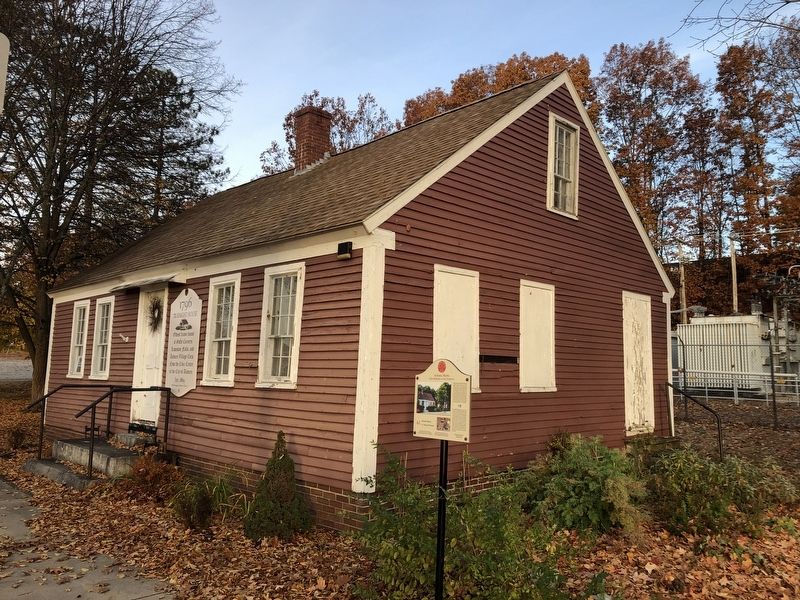
Named for the Knight family, the building's longest occupants, the "Knight House" stands as the oldest frame house in downtown Auburn. It is a typical example of houses built in the late 1700s. Nathaniel Knight was a butcher and meat . . . — — Map (db m186025) HM
In memory of
Asa Clapp
A seaman of the American Revolution
Merchant, an upbuilder of Portland
1762 ✠ 1848
Asa William Henry Clapp
Citizen of Portland
A conservator of its interests
Member of
the Congress of . . . — — Map (db m185934) HM WM
Declared a National Historic Site January 1974
Here lie the hardy courageous early settlers, the men and women who founded and defended this area, who made history in civil life, government, law, the arts, education, religion, in the state and . . . — — Map (db m50432) HM
1754: Third Parish, Stroudwater, votes to become a Church of England Parish. Pastor sent to England to be Ordained Priest of that Church.
1763: Third Parish reorganizes as Church of England Parish, under The Rt. Rev'd. Richard . . . — — Map (db m186362) HM
To the memory of our historic dead who bore arms in the War of Independence and who were ever the brave defenders of our country who made her foundations so enduring — — Map (db m50430) WM
Fort Sumner Park, located behind you acros North Street, began its history in 1775 during the Revolutionary War. Initially referred to as The Great Fort, and later, as The Citadel, it was commissioned in 1794 as the first . . . — — Map (db m186400) HM
This area is the site of Fort Preble, also known as Fort Hancock during the Revolutionary War, a temporary fort. Fort Preble was begun in 1808 during the administration of Pres. Jefferson and completed before the War of 1812. It was named for . . . — — Map (db m55568) HM
Photo captions starting center left at main illustration and going clockwise:
Penobscot Expedition
On July 28, 1779, in what is known as the Penobscot Expedition, American forces led by the Marines stormed the western bluffs of the . . . — — Map (db m145059) HM
THE MILITARY HISTORY of our nation came to Bucksport quite dramatically over the centuries. The young settlement was occupied by the British during the War of 1812 and gained its most prominent view, Fort Knox, in the 1840s, built to protect . . . — — Map (db m233480) HM
In 1763 Jonathan Buck settled the area, which was subesequently burned during the Revolutionary War. First incorporated as "Buckstown", the name was changed to "Bucksport" in 1817. In the 1800's Bucksport thrived as an international port. Later . . . — — Map (db m55112) HM
Battle on the River
In 1779, the early settlers of Bucksport witnessed a devastating military defeat for the Americans during the Revolutionary War. A fleet of 44 warships and support vessels from the Continental Navy Fleet set out on a . . . — — Map (db m183880) HM
This Fortress, originally known by its garrison as FORT PENOBSCOT and named by Admiral Sir George Collier in his reports FORT CASTINE received its present designation from its builder, British general Francis McLean upon its completion in December . . . — — Map (db m77148) HM
This fort, originally known by its garrison as “Fort Penobscot” and named by Admiral Sir George Collier in his reports “Fort Castine” received its present designation from its builder, British general Francis McLean upon its . . . — — Map (db m77147) HM
Built in 1780 by Colonel Campbell, named in honor of his regiment, H.B.M. 74th - “The Argyle Highlanders,” following a southerly direction to the shore.
Upon the explosion of the Tory refugees - September-October, 1784, a . . . — — Map (db m77152) HM
In memory of
Militiamen - Rangers of Plts. 8 8-9. Now
Franklin
who served in
1775 - Revolutionary War - 1781
Defense of Machias - Frenchman's Bay - Siege of Bacaduce
Jeremiah Bragdon ·
John Bragdon ·
Moses Butler Sr. ·
Moses . . . — — Map (db m233874) HM WM
All the mountains that you see are part of Acadia National Park
The Age of Sail lingered into the 1900s as sailing ships proved more economical than steamships for carrying heavy cargos such as granite.
Generations of watercraft ply . . . — — Map (db m54707) HM
An expedition under
Colonel Benedict Arnold
for the capture of Quebec
marched from this place
in September 1775
☆☆☆☆☆☆☆☆☆☆☆☆☆
To record . . . — — Map (db m110856) HM WM
On June 8, 1834, Judge Daniel Cony's home was consumed by fire. Judge Cony had erected the frame of that house on October 17, 1797, on the 20th anniversary of the capture of General Burgoyne's army. Cony was a Massachusetts militia . . . — — Map (db m186064) HM
This reproduction of the Liberty Bell was presented to the people of Maine by direction of The Honorable John W. Snyder Secretary of the Treasury
As the inspirational symbol of the United States Savings Bonds Independence . . . — — Map (db m128550) WM
Near this spot stood the 1771 homestead of the Elias and Mary Taylor family, pioneer settlers of Kennebec, Cushnoc, Hallowell, Winthrop and Manchester and Patriots of the American Revolution. In 1775 their eldest son John Taylor joined the . . . — — Map (db m123670) HM
Native Americans inhabited this site at the confluence of the Kennebec and Sebasticook Rivers from at least 5000 years ago, until 1692.
A pilgrim trading post was also located on this site in the 1650s.
Located within Fort Halifax Park is . . . — — Map (db m116136) HM
American Patriot Paul Revere is best known for his midnight ride on April 18, 1775, warning colonists of the advancing British forces. Although generations of people know Revere as an American hero, others know him as a noted silver and . . . — — Map (db m105554) HM
Born in
Shrewsbury Mass.
Nov. 19, 1752,
Died in
Bangor Me.
May 21, 1844.
He served in the War of the Revolution as
Lieutenant in the 5th Regiment of Massachusetts;
and in grateful memory of that service the . . . — — Map (db m110692) HM WM
This tablet marks the place where Colonel Benedict Arnold with his soldiers left the Kennebec River October 1775 and marched from the west shore in a north-westerly direction to Dead River on their way to Quebec.
— — Map (db m102371) HM
The largest combined infantry-naval operation undertaken by the American colonists during the Revolution met with disaster along this waterway. Two thousand colonials failed to capture Fort George at Castine with its contingent of 750 British land . . . — — Map (db m21458) HM
Today's peaceful view of the Penobscot River and the community of Bucksport holds few hints of the early conflicts that plagued the area. For nearly two centuries, the river served as a border between clashing interests - French and English, Native . . . — — Map (db m55132) HM
Planted in honor of those who lost their lives in the tragic events on September 11, 2001
The American Liberty elm was named after "The Liberty Tree": Our Country's first Symbol of Freedom. On the morning of August 14, 1765, the people of Boston . . . — — Map (db m55341) HM WM
Fort Point Light — An Early River Beacon Established in 1836 to aid the growing number of ships navigating the Penobscot between Bangor and Castine, Fort Point Light Station was built as the first river light in Maine. In 1857, the . . . — — Map (db m170845) HM
Erected and named by Gen Thomas Pownall 1759 • • • Gen Samuel Waldo for whom Waldo County was named was buried here Removed to Kings Chapel Boston • • • Erected by John Cocran Chapter D.A.R. 1916 — — Map (db m170848) HM
In 1759, Massachusetts Governor Thomas Pownall sought to plug the mouths of Maine's key rivers so as to keep the French and Indians well inland. In January 1758, he wrote to William Pitt, Prime Minister of England about the advantages of this site, . . . — — Map (db m170846) HM
Early Settlers of the Pleasant River Known to Have Been in Action Against the British During the Revolution of 1775 to 1783
[Honor Roll of Veterans] — — Map (db m55088) HM WM
Hannah Watts was born in 1758 at about the same time that the Indian War was raging in New England. Around 1760 Captain Samuel Watts,
Hannah's father, moved his family from Haverill, Massachusetts to Falmouth, Maine. The family resided there for a . . . — — Map (db m183783) HM
This anchor symbolizes the historic ties that Machias people have with the sea, and their commitment to liberty as exemplified in the first naval battle of the American Revolution fought in Machias Bay between the British ship Margaretta and the . . . — — Map (db m55066) HM WM
On June 12, 1775, about two miles off-shore near Round Island, the first naval battle of the American Revolution took place. This was the first instance of armed naval combat between Americans and a foreign power, and as such, the United States . . . — — Map (db m145040) HM
Historic Fort Machias
Built in 1775 immediately after the first naval
battle of the American Revolution took place
offshore, Fort Machias was a four-gun battery
that guarded the mouth of the Machias River in
cooperation with Fort . . . — — Map (db m145018) HM
On June 24, 1825, General Lafayette spent the night here at Spring's Tavern on his way
to Portland. He stopped again on June 26 traveling south. — — Map (db m204927) HM
"Squire" Samuel Peirson's House was located on the site of Phillip's garrison house destroyed by the Indians in 1675 during King Phillip's War. The house shown here was erected in 1767 by Jeremiah Hill who died in 1820. Samuel . . . — — Map (db m186155) HM
August 8, 1782, a British ship of 18 guns attacked a small force of inhabitants gathered on Goat Island and was driven away by severe musket fire, losing 17 men. Lieut. James Burnham of this town was killed.
This tablet was erected August 8, . . . — — Map (db m55672) HM
This Second Empire style home with mansard roof was built for merchant George Wise in 1868 just three years after the Civil War ended. This home occupies the site which was previously owned by George's father, Captain Daniel Wise, . . . — — Map (db m186338) HM
This Colonial Saltbox home was built c.1750 making it one of a handful of colonial homes still left standing in Kennebunk. It was built for Captain James Hubbard who was originally from Berwick, Maine. Hubbard commanded of a company . . . — — Map (db m186339) HM
This home was constructed in 1758 by Joseph Storer and his wife Hannah. Storer was the wealthiest man in Kennebunk at the time and owned a saw mill, country store and grist mill. He entered into the Revolutionary War in 1777. He was . . . — — Map (db m186308) HM
A: Blockhouse (1844)
B: Riflemen's House (1808-1812)
C: Magazine (early 1800s)
D: Lower Battery (early 1800s)
E: Granite Outer Wall (Civil War era, unfinished)
The site at Kittery Point has been used for defensive purpose since 1689. . . . — — Map (db m161810) HM
In memory of the Continental sloop of War Ranger launched from this island May 10, 1777 Sailed for France November 1777 John Paul Jones, Captain with dispatches of Burgoyne’s surrender received February 14, 1778 The first salute to the Stars and . . . — — Map (db m85419) HM
Forts at this site have protected Portsmouth Harbor since 1689 when some earthworks and a small blockhouse were built here at what was then called Pepperrell's Garrison after the area's most prominent settler, William Pepperrell. In 1715, the . . . — — Map (db m161809) HM
Erected to the memory of
the Country’s Defenders
1775 – 1865
With malice toward none,
With charity for all,
With firmness in the right,
As God gives us
To see the right — — Map (db m55691) HM