On Main St (Massachusetts Route 6A) 0.1 miles east of Railroad Ave, on the right when traveling east.
James Otis Jr.
The Patriot
West Barnstable
1725 — 1783
Advocate Orator Statesman
President John Adams Said In Part
Of Otis’s Famous Writs Of Assistance
Speech In Boston February 1761
“American Independence . . . — — Map (db m142330) HM
On Main St (Massachusetts Route 6A) at Rendezvous Lane, on the left when traveling east on Main St.
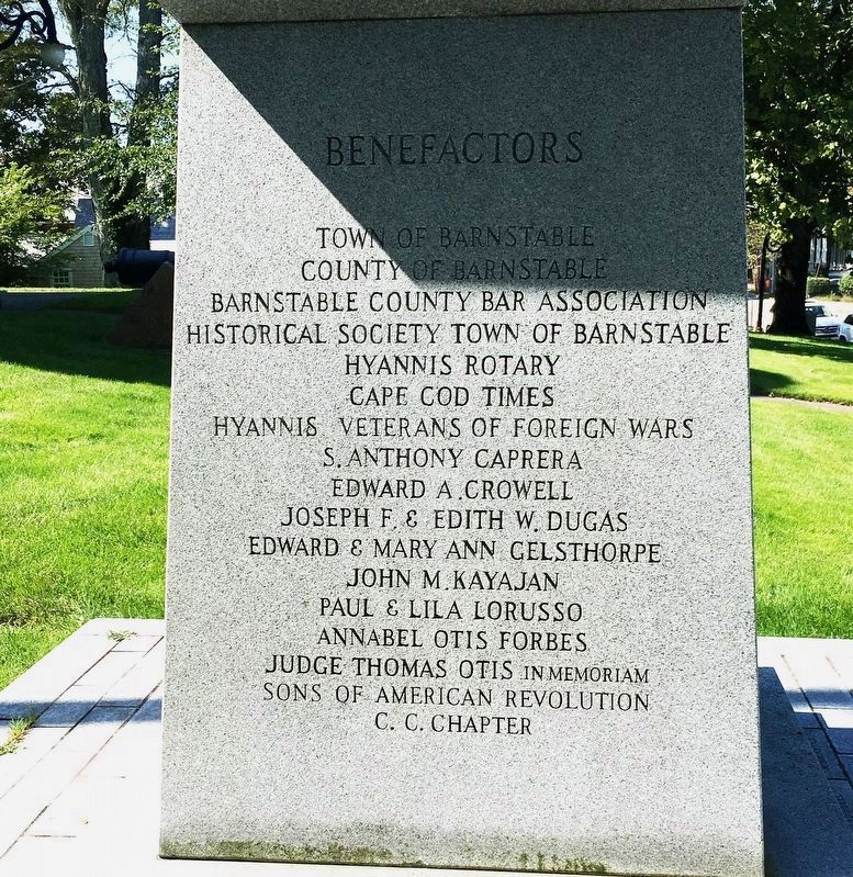
In Honor Of The
Men Of Barnstable
Who Served In
The Revolution
The War Of 1812
The Civil War
The War With Spain
The War With Germany
This Stone Marks The Spot
From Which The Soldiers
Marched To Boston
In . . . — — Map (db m142182) WM
On Rendezvous Lane at Main Street (Massachusetts Route 6A), on the right when traveling north on Rendezvous Lane.
:
In Tribute To
Mercy Otis Warren
Poet, Playwright, Historian And
Political Pamphleteer
On The Occasion Of
The 225th Anniversary Of The
Start Of The American Revolution
1775 - 2000
* * * * *
Member of a . . . — — Map (db m142177) HM WM
Chatham’s only active hostilities
during the Revolutionary War occurred in Chatham Harbor,
near this site, on 20 June 1782.
At sunrise, crew members from a British privateer were discovered in Chatham’s East Harbor, attempting to sail away . . . — — Map (db m78440) HM
Of all the enemy ships that haunted Provincetown Harbor during the Revolutionary War, perhaps the most fearsome was the huge British man-of-war H.M.S. Somerset. With her 64 mounted guns and crew of 400, she symbolized British tyranny where-ever she . . . — — Map (db m111670) HM
In Memory
of those members and associates of the East Hoosuck Society of Friends who, laying aside their religious scruples, took up arms, in the War for Independence in defense of their homes and liberties.
In the Friends Burial . . . — — Map (db m118632) WM
On North Street (Massachusetts Route 8) 0.2 miles north of Mountain Road/Church Street, on the left when traveling north.
This bas-relief, the original of which was erected on Bennington Battlefield on Walloomsac Heights in the State of New York by the Commonwealth of Massachusetts, was dedicated by
Eugene Bucklin Bowen
to the memory of the six hundred and more . . . — — Map (db m118586) HM WM
On Egremont Plain Road (Massachusetts Route 71) at Prospect Lake Road, on the right when traveling south on Egremont Plain Road.
Through this place passed General Henry Knox in the winter of 1775 – 1776 to deliver to General George Washington at Cambridge the train of artillery from Fort Ticonderoga used to force the British Army to evacuate . . . — — Map (db m24017) HM
On Main Street (U.S. 7) at Castle Street, on the left when traveling north on Main Street.
Near this spot stood the first court house of Berkshire County erected 1764. Here August 16, 1774 occurred the first open resistance to British rule in America — — Map (db m58957) HM
On Massachusetts Route 23 at U.S. 7, on the left when traveling east on State Route 23.
Through this place passed General Henry Knox in the winter of 1775 – 1776 to deliver to General George Washington at Cambridge the train of artillery from Fort Ticonderoga used to force the British Army to evacuate Boston. Erected by the . . . — — Map (db m24013) HM
On Main Street / Old Stockbridge Road (Massachusetts Route 7A) at Walker Sreet / West Street (Massachusetts Route 183), in the median on Main Street / Old Stockbridge Road.
Paterson
In memory of Major General John Paterson, son of Colonel John Paterson, born 1744, died 1808; and Elizabeth Lee his wife, born 1749, died 1841. He was born in New Britain, Conn. Graduated at Yale . . . — — Map (db m180228) HM
On Massachusetts Route 23, on the left when traveling east.
Through this place passed General Henry Knox in the winter of 1775 – 1776 to deliver to General George Washington at Cambridge the train of artillery from Fort Ticonderoga used to force the British Army to evacuate Boston. Erected by the . . . — — Map (db m24007) HM
On E. Otis Road (Massachusetts Route 23) at West Shore Road, on the left when traveling south on E. Otis Road.
Through this place passed
General Henry Knox
in the winter of
1775 – 1776
to deliver to
General George Washington
at Cambridge
the train of artillery
from Fort Ticonderoga used
to force the British Army
to evacuate Boston. . . . — — Map (db m97510) WM
On East Street (Massachusetts Route 9) at North Street (Massachusetts Route 9), on the right when traveling east on East Street.
Peace Party House
Built by Col. James Easton in 1776 on the site in front of the court house
Home of John Chandler Williams in 1782 and moved to its present location in 1869
Here in November, 1783 a brilliant party and a notable feast were given . . . — — Map (db m85250) HM
On Main Street (Massachusetts Route 2) at Colonial Avenue, on the right when traveling west on Main Street.
Built 1772 as a farmhouse and tavern. Benedict Arnold slept here May 6, 1775 enroute to help Ethan Allen take Fort Ticonderoga. Bread baked here for Battle of Bennington, Aug. 16, 1777. — — Map (db m118657) HM
To Perpetuate the memory of the Revolutionary War Soldiers buried in this Old Kirk Yard
William Balcom •
Jacob Balkom •
Hezekiah Bishop •
Zephanian Bishop •
Zephanian Bishop Jr •
Daniel Blanding •
Noah Blanding •
Darius Briggs • . . . — — Map (db m57933) HM
The building of this church began in 1770 on the eastern edge of the Great Cornfield of the Pocanocket Indians. Construction was halted during the American Revolution and the church was used as soldiers farmed and sheepfold. Completion was in 1798. . . . — — Map (db m66342) HM
Near Fort Street west of Beacon Street, on the right when traveling west.
In Memory of
Historian, Author, and Fire Chief
Donald R. Bernard
1932 - 1993
Who led Revolutionary and
Civil War Re-enactments on
this site. His efforts brought
awareness of the significant
role the area . . . — — Map (db m88205)
On Fort Street, on the right when traveling south.
Built for harbor defense in 1775. Destroyed by the British September 6th 1778. Later rebuilt and now the property of the town of Fairhaven. — — Map (db m52383) HM
On Fort Street west of Beacon Street, on the right when traveling west.
In May 1775, British General Gage, bottled up in Boston Harbor after the Battle of Concord and Lexington in 1775, sent the HMS Falcon to Martha's Vineyard and the Elizabeth Islands in search of food and supplies. Two of the . . . — — Map (db m86947) HM
On Fort Street west of Beacon Street, on the right when traveling west.
1775 - First naval encounter of American Revolution.
1778 - Captured and destroyed by the British.
1812 - Repelled British attempt at capture.
1861 - Manned by Federal troops in defense of this harbor. — — Map (db m88055) HM
On Fort Street west of Beacon Street, on the right when traveling west.
The fortress structures of Fort Phoenix remaining today are the parapet, built before the Civil War, and the gunpowder magazine, completed in 1865. The Civil War era officer's quarters and barracks were destroyed by fire in 1918.
The shape and . . . — — Map (db m88105) HM
On Fort Street west of Beacon Street, on the right when traveling west.
Erected in Memory of
Major Israel Fearing
the Ardent Patriot and
Accomplished Soldier
————
On the 7th day of September 1778
the British troops landed from
their ships in the bay for the . . . — — Map (db m88084) HM
Near Fort Street west of Beacon Street, on the right when traveling west.
Taken from the British at Nassau 1777, by Colonial ship of war Alfred - Placed on Fort Phoenix Recaptured by British and left on the fort spiked, and with trunions knocked off - Afterwards mounted in Union street for village defense. Placed here . . . — — Map (db m88106) HM
On North Main Street at brightman Street, on the right when traveling south on North Main Street.
Colonel Durfee was born in Fall Rive (then Freetown) April 27th, A.D. 1750, and died in Freetown, December 10th, A.D. 1841. He rendered distinguished service at the Battles of Long Island and White Plains, in New York, and at the Battle of Rhode . . . — — Map (db m244691) WM
On MacArthur Drive south of Elm Street, on the left when traveling south.
Text on the Bronze Plaque
Near this Site
was located the shipyard of
Colonel George Claghorn
Builder of U.S. Frigate Constitution
and Ship Rebecca the first whaler
to double Cape Horn.
His service in the . . . — — Map (db m86782) HM
On Centre Street at Front Street, on the left when traveling east on Centre Street.
Near this spot in 1767 the first ship built in New Bedford was launched.
The Dartmouth
Francis Rotch, Owner
She was one of the vessels boarded by the Boston Tea Party in 1773
— — Map (db m58183) HM
On Bay Road close to Turkey Farm Road, on the right when traveling north.
The First Burial Ground is the presumed buying place of Norton's pioneer settler's.
William Witherell, who died in September 1691, is buried in the West end of the burial ground. When the land was passed to Nathaniel Witherell by his father,the . . . — — Map (db m52379) HM
On Chestnut Street north of Brook Street, on the right when traveling north.
When the British occupied Newport, RI. during the Revolution they often threatened the surrounding towns with raids or "alarums" as they were called. When a raid began a system of beacon fires were lit to warn the militia in neighboring towns to . . . — — Map (db m55911) HM
During the American Revolution, a large white oak called "the Liberty Tree" stood near this place, which was then near the edge of a field. Beacons warning of trouble in Rhode Island could be seen by watchers at nearby Horton's Signal. After . . . — — Map (db m55918) HM
On South Summer Street at Davis Lane, on the right when traveling south on South Summer Street.
Home of Benjamin Smith who was commissioned in 1775 Captain of the First Company, Martha’s Vineyard Militia, Massachusetts, for the defense of the seacoast. Marker placed by Martha’s Vineyard Seacoast Defence Chapter, National Society of the . . . — — Map (db m177888) HM WM
On Main Street at Colonial Lane, on the left when traveling north on Main Street.
To commemorate the Patriotism of three girls of this village Polly Daggett •
Parnel Manter • Maria Allen who destroyed with powder a liberty pole erected near this spot to prevent its capture by the British in 1776. This pole, replacing the . . . — — Map (db m177589) HM
Near Douglass Lane north of Mortimer Drive, on the left when traveling north.
This cemetery is the family burial ground for the Woodbridge and Jenkins families. The burial ground and adjacent historic 1765 Benjamin Jenkins' farmstead date from the late 18th century colonial period. Colonel Benjamin Jenkins was a . . . — — Map (db m243104) HM
On Bay View Road, 0.2 miles south of Neptune Street, on the right when traveling north.
[Bottom (larger) Marker]
Hospital Point Light was established in 1871 and marks the deep-water channel to Beverly, Salem, and Marblehead.
A smallpox hospital once stood on the hill to the rear, where there is also evidence of ramparts . . . — — Map (db m21441) HM
On Bay View Road, 0.2 miles south of Neptune Street, on the right when traveling north.
Hospital Point Light was constructed and first lighted in 1872 to help guide vessels into Salem and Beverly Harbors. The original two-story keeper's house and oil house are still being used.
The name Hospital Point stems from a smallpox . . . — — Map (db m21429) HM
On Main Street at Washington Street (Massachusetts Route 133), on the left when traveling north on Main Street.
In Memory of
Col. Thomas Knowlton
Born in West Boxford
November 22, 1740
Leader of America's First
Ranger Unit,
Knowlton's Rangers
Died in the Battle of
Harlem Heights
Serving Under
George Washington
on September 16, . . . — — Map (db m184034) HM
Near Conant Street at Conant Street & High Street (Massachusetts Route 35).
One of the most strategic and daring exploits of the patriot cause during the revolution. Part of the troops encamped in the Town of Danvers on the night of September 14, 1775 on their way to Newburyport where they embarked for the Kennebeck and . . . — — Map (db m48470) HM
On Pine Street at Adams Street, on the left when traveling north on Pine Street.
In 1636 Francis Weston was granted this land upon which he laid out a farm. This property was purchased by Governor John Endicott in 1648, and in 1678 Francis and Rebecca Nurse moved here and built a house. In March, 1692, 71-year-old Rebecca was . . . — — Map (db m185940) HM
On Water Street, on the left when traveling north.
Site of Israel Hutchinson's Home
—
Here were brought Danvers
Soldiers slain at the
battle of Lexington —
This memorial is a tribute to his
memory, from lineal decendants,
and the town of Danvers. —
1896
. . . — — Map (db m47197) HM
On Centre Street, on the right when traveling west.
Defense was a prime necessity to the early settlers of Salem Village, and as early as 1671 the male inhabitants began meeting here for military drill. This preparation was heightened in 1675 during the King Philip War in which many villagers took . . . — — Map (db m17991) HM
Near Western Avenue (Massachusetts Route 127) at Essex Avenue (Massachusetts Route 133), on the right when traveling north.
[ upper plaque ]
In Memory of those who fought in the Revolutionary War with the Nathaniel Warner Company and those men and women who helped make this a free and independent nation.
Placed by the reactivated
Nathaniel Warner . . . — — Map (db m36354) HM
Near Western Avenue (Massachusetts Route 127) at Essex Avenue (Massachusetts Route 133), on the right when traveling north.
In memory of the soldiers and sailors and all others who rendered aid to the cause of American Independence during the Revolutionary War
Erected by Lucy Knox Chapter Daughters of the American Revolution of Gloucester
June 17, 1913 — — Map (db m36356) HM
On S. Main Street at S. Village Green, in the median on S. Main Street.
Side 1 A few rods east of this spot were the dwelling and school house of Ezekiel Cheever first master of the Grammar School 1650-1661. In the east side of the common was the home of Rev. Nathaniel Ward 1634 Minister of Ipswich 1637 . . . — — Map (db m97170) HM WM
Near Front Street at Fort Sewall Terrace, on the right when traveling north.
[ left panel ]
Welcome – You Are Entering
Fort Sewall
Marblehead Massachusetts
Fort Sewall is a unique earthwork fortification positioned to defend Marblehead for over three centuries. In 1644 the provincial government granted . . . — — Map (db m36601) HM
Near Front Street at Fort Sewall Terrace, on the right when traveling north.
Gen. Casimir Pulaski
Arrived in Salem Harbor at
Fort Sewall Marblehead
July 23, 1777
Revolutionary War Hero
Polish and American Patriot
Died in Battle at Savannah, GA
October 11, 1779
Erected 1989
Polish American Congress . . . — — Map (db m36605) HM WM
On High Street (Massachusetts Route 1A) at Green Street, on the right when traveling south on High Street.
Brought from the siege of
Louisburg
by Nathaniel Knapp Jr. 1759
preserved by his son
Isaac Knapp
as a memorial to his father
and also to his brother
Jacob Knapp
who served at Bunker Hill
and was a member of the . . . — — Map (db m115543) HM
Near High Street (Massachusetts Route 1A) at Green Street, on the right when traveling south.
It was first shaped thousands of years ago by a huge chunk of ice which broke off a retreating glacier.
When the ice finally melted, it left a steep-sided pit that geologists call a kettle hole.
In 1645 the first settlers from England named . . . — — Map (db m115536) HM
On Greenleaf Street north of Pond Street, on the left when traveling north.
(left tablet)
Reverend …
John Lowell
Thomas Cary
John Murray
Charles Milton
Christopher Bridge Marsh
Ministers of this City
Judge Theophilus Bradbury
Nicholas Pike
Timothy Palmer
”Lord” Timothy . . . — — Map (db m115614) HM WM
On South Street, on the right when traveling north.
Answering a sudden alarm to meet at the house of Lieutenant Benjamin Tarr, grandson of Richard Tarr the first settler, sixty-six men from this village under Captain John Rowe, marched to Charlestown and fought in the Battle of Bunker Hill. — — Map (db m73109) HM
On Beach Street, on the right when traveling south.
Original plot given by the first settler, Richard Tarr, who was buried here in 1732. Here lie most of the early settlers and many of the officers and soldiers of the French and Indian, Revolutionary and 1812 Wars. — — Map (db m48841) HM
To the glory of God and in honor of the first settlers of Sandy Bay
The First Parish in Rockport was constituted in 1755. The corner stone of this meeting house laid in 1803. The tower was shattered by a British bombardment in 1814. . . . — — Map (db m73110) HM
On Broad Street at Winthrop Street, on the right when traveling east on Broad Street.
Notable Internees:
George Corwin, Jr. d. 1696
High Sheriff during Salem Witch Trials
Jonathan Corwin d. 1718
Salem Witch Trial Judge
Capt. John Felt d. 1796
Played key role in Leslie's Retreat
Jonathan Haraden d. 1803
Legendary . . . — — Map (db m223343) HM
On New Liberty Street at Brown Street, on the right when traveling north on New Liberty Street.
A Polish patriot in exile, first arrived
in America at Salem Harbor, July, 1777.
His military skills and devotion to
the ideals of liberty and justice led
him to offer his services to the cause of
the American Struggle for Independence,
he is . . . — — Map (db m221820) HM
On New Liberty Street at Brown Street, on the left when traveling south on New Liberty Street.
Essex County Militiamen
respond to the Lexington
Alarm of April 19, 1775 and take
part in the fiercest fighting
of the day in Arlington. Essex
Militiamen later fight at
Bunker Hill and help form
units of the Continental Army. — — Map (db m220833) WM
On North Street at North Street & Commercial Street, on the right when traveling south on North Street.
In the Revolution the first armed resistance to the Royal authority was made at this bridge 26 Feb. 1775 by the people of Salem. The advance of 300 British troops, led by Lt. Col. Leslie and sent by Gen. Gage to seize munitions of war, was here . . . — — Map (db m48471) HM WM
Here, in defiance of King George III, local minutemen hid 17 cannons, and were confronted by 300 British troops under command of Colonel Leslie. The Redcoats were routed, with only Joseph Whicher of Salem being wounded. This was the first open . . . — — Map (db m47991) HM
On Church Street just west of St Peter Street, on the right when traveling west.
This Liberty Tree and Plaque were dedicated on Patriots' Day, 1976 to the memory of Benjamin Peirce, a baker, the only Salem Minuteman killed on April 19, 1775 at Menotomy (Arlington). — — Map (db m230437) HM WM
On Cambridge Street, on the right when traveling north.
Cur non?
In memory of Major General Marquis de Lafayette
soldier, statesman,
citizen of France
and of the United States.
On August 31, 1824
Lafayette was the guest
of honor
at a banquet held
in this building. . . . — — Map (db m220801) HM
Near New Liberty Street at Brown Street, on the left when traveling south.
In the wake of the Boston Tea Party, the British Crown enacted punitive measures against the colonies. These action created considerable unrest, particularly in Massachusetts. In Essex County, colonial militias began to drill, stockpile stores of . . . — — Map (db m220826) HM
On Washington Square (Massachusetts Route 1A) just south of Oliver Street, on the right when traveling south.
Salem Common was originally a nine-acre parcel of swampy land used for grazing livestock and training the local militia. In 1637, the first regiment of the Massachusetts Bay Colony militia to muster (train) was the East REgiment. This volunteer . . . — — Map (db m186220) HM
On Broad Street at Winthrop Street, on the left when traveling east on Broad Street.
Built By John Pickering 1660
Here Was Born In 1745
Col. Timothy Pickering
In The Revolution He Was
Quartermaster General And
President Of The Board Of War
In Washington's Cabinet He Was
Secretary Of State, Secretary of War
and . . . — — Map (db m220805) HM
On Washington Street at Essex Street, on the right when traveling north on Washington Street.
Three rods west of this spot
stood, from 1718 until 1785,
The Town House.
Here Governor Burnet convened
The General Court in 1728 and 1729,
a Town Meeting held here in 1765
protested against The Stamp Act,
and another in 1769, . . . — — Map (db m85899) HM
On N Washington Square at Winter Street, on the right when traveling north on N Washington Square.
From 1775 to 1783, Salem played a significant
role in the American Revolutionary
War, from the first armed resistance at
"Leslie's Retreat" to privateers sailing out
of Salem accounting for more than half of
all captured British vessels. . . . — — Map (db m221272) HM
Near Winthrop Street south of Broad Street, on the right when traveling north.
Revolutionary War Soldier & Patriot
Timothy Pickering
Col. - 1st Regt., Essex Co. Militia, MA
Quartermaster General &
Adjutant General Continental Army
Member Board of War
Born 6 July 1745 Salem, Essex Co., MA
Died 29 January 1829 . . . — — Map (db m220810) WM
Near Essex Street, on the right when traveling north.
Veterans of the Revolutionary
War realize the need for military
preparedness and civil order and
organize the Salem Cadets, later
the Second Corps of Cadets, on
July 10, 1786. The Cadets are one of
the first volunteer militia units
in the . . . — — Map (db m221816) HM
On Monument Avenue at Elmwood Road, on the left when traveling north on Monument Avenue.
Revolutionary War
Honor Roll 1775 – 1783
Burrill, Alden • Burrill, Ebenezer • Burrill, John A. • Burrill, John M. • Burrill, Samuel • Burrill, Theophilus • Clark, Edmund • Ingalls, Benjamin • Ingalls, Jacob • Ingalls, John • Ingalls, Joseph . . . — — Map (db m36706) HM
On Old Main St, 0.2 miles north of Albany Rd, on the left when traveling north.
Home of Joseph Stebbins
Born 1749 Died 1816
Lover of Liberty
And
Servant of His Country
__________
Lieutenant of Minute Men
Who Marched on the Lexington Alarm
Captain at the Battle of Bunker Hill
Fought at Stillwater . . . — — Map (db m141334) WM
On Otis Stage Road (Massachusetts Route 23) at N Blandford Road, on the left when traveling east on Otis Stage Road.
Through this place passed General Henry Knox in the winter of 1775 – 1776 to deliver to General George Washington at Cambridge the train of artillery from Fort Ticonderoga used to force the British Army to evacuate Boston. Erected by the . . . — — Map (db m24011) HM
On Sturbridge Road at E Brimfield Road, on the right when traveling east on Sturbridge Road.
In memory of
Benjamin Church
1756-1832
Soldier of the American Revolution
served in
General Lee’s Life Guard, 1775
General Artemus Ward’s Life Guard and
Captain Burbank’s Artillery, 1776
General Washington’s Life Guard, 1776
Took . . . — — Map (db m106285) HM WM
On Wilbraham Street (U.S. 20) at Main Street (Massachusetts Route 181), on the left when traveling east on Wilbraham Street.
Through this place passed General Henry Knox in the winter of 1775 – 1776 to deliver to General George Washington at Cambridge the train of artillery from Fort Ticonderoga used to force the British Army to evacuate Boston. Erected by the . . . — — Map (db m24016) HM
On Wilbraham Street (U.S. 20), on the left when traveling east.
Dedicated by Wright Wire Company, 1919, to its employees and their families, for their recreation and pleasure. George Washington, Father of his country – first President of the United States – traveled over this spot in June 1775 on . . . — — Map (db m24388) HM
On General Knox Road at South Quarter Road, on the right when traveling south on General Knox Road.
Through this place passed General Henry Knox in the winter of 1775 – 1776 to deliver to General George Washington at Cambridge the train of artillery from Fort Ticonderoga used to force the British Army to evacuate Boston. Erected by the . . . — — Map (db m24010) HM
On State Street, on the right when traveling south.
Through this Place Passed
General Henry Knox
In the Winter of
1775 - 1776
To Deliver To
General George Washington
At Cambridge
The Train of Artillery
From Fort Ticonderoga Used
To Force the British Army
To Evacuate . . . — — Map (db m23756) HM
On Park Avenue (Massachusetts Route 20) at Main Street, on the left when traveling east on Park Avenue.
Through this place passed General Henry Knox in the winter of 1775 – 1776 to deliver to General George Washington at Cambridge the train of artillery from Fort Ticonderoga used to force the British Army to evacuate Boston. Erected by the . . . — — Map (db m24008) HM
On Park Avenue (Massachusetts Route 20) at Main Street, on the left when traveling east on Park Avenue.
Here encamped Oct. 30 and 31, 1777, Gen. Riedesel and his Hessian soldiers on their way to Boston after Burgoyne’s surrender at Saratoga. — — Map (db m24075) HM
On Main Street (U.S. 20) at U.S. 202, on the right when traveling east on Main Street.
Through this Place Passed
General Henry Knox
In the Winter of
1775 - 1776
To Deliver To
General George Washington
At Cambridge
The Train of Artillery
From Fort Ticonderoga Used
To Force the British Army
To Evacuate . . . — — Map (db m23754) HM WM
On Court Street (U.S. 202) at Holland Avenue, on the right when traveling east on Court Street.
A friend of Liberty and his country Soldier in the American Revolution Armorer to the 18th Mass. regiment Built armory at Mt. Tekoa circa 1765 Made muskets for the patriot cause This was the site of his home and blacksmith shop circa 1764 to 1783 . . . — — Map (db m24077) HM
On Boston Road (U.S. 20) near Main Street, on the right when traveling east.
Through this place passed General Henry Knox in the winter of 1775 – 1776 to deliver to General George Washington at Cambridge the train of artillery from Fort Ticonderoga used to force the British Army to evacuate Boston. Erected by the . . . — — Map (db m24014) HM
Near Main Street (Massachusetts Route 10) at Masonic Street, on the right when traveling east.
To perpetuate the memory of Brigadier General Casimir Pulaski an American Revolutionary War Hero, who, from wounds received at the siege of Savannah, Georgia, died on October eleventh, 1779.
This memorial is erected in testimony of . . . — — Map (db m138431) WM
On Main Street near Masonic Street, on the left when traveling west.
To perpetuate the memory of Brigadier General Casimir Pulaski, an American Revolutionary War hero, who, from wounds received at the Siege of Savannah, Georgia, died on October eleventh, 1779.
This memorial is erected in testimony of respect by . . . — — Map (db m194943) HM
Near Main Street (Massachusetts Route 10) at Masonic Street, on the right when traveling east.
During the late 18th century, the site of Pulaski Park was used extensively for public auctions and as a congregating place for horse traders. Public announcements were made there, and tradition has it that news of the British attack on Lexington . . . — — Map (db m138434) HM WM
On Huntington Road (Massachusetts Route 112) at Buffington Hill Road, on the right when traveling south on Huntington Road.
General LaFayette, friend of America in its struggle for liberty,
visited Worthington June 13, 1825.
Was a guest overnight at the tavern
then located on this site. — — Map (db m155524) HM
On Jason Street, on the right when traveling south.
Built by Martha, widow of William Russell, about 1680. Occupied until 1890 by her descendants, of whom Jason Russell lost his life in the conflict of April 19, 1775. — — Map (db m43052) HM
On Massachusetts Avenue (U.S. 3) at Pleasant Street (Massachusetts Route 60), on the right when traveling east on Massachusetts Avenue.
At this spot on April 19, 1775 the Old Men of Menotomy captured a convoy of eighteen soldiers with supplies on its way to join the British at Lexington. — — Map (db m18138) HM
On Massachusetts Avenue (U.S. 3) at Mystic Street (Massachusetts Route 60), on the right when traveling west on Massachusetts Avenue.
Near this spot Samuel Whittemore, then 80 years old, killed three British soldiers April 19, 1775. He was shot, bayoneted, beaten and left for dead, but recovered and lived to be 98 years of age. — — Map (db m18142) HM
On Massachusetts Avenue at Lowell Street, on the right when traveling west on Massachusetts Avenue.
1635 Menotomy 1807 West Cambridge 1867 Arlington This park is dedicated by the people of Arlington to the memory of Colonial Minutemen and British soldiers who met here in the first great battle of the Revolutionary War. British troops in retreat . . . — — Map (db m18613) HM
366 entries matched your criteria. The first 100 are listed above. Next 100 ⊳