Athabascans were highly nomadic, traveling in small groups to fish, hunt, and trap.
Athabascan territory, the largest area of all the Alaska Native peoples, was home to 11 different linguistic groups who lived along five major riverways: the . . . — — Map (db m72795) HM
“Our people had log houses without nails and we all lived the same. We lived subsistence way of life, and love it that way. We have our fish houses, drying racks and all that.”
Alberta Stephan, . . . — — Map (db m72796) HM
Athabascans were masters at designing a variety of shelters--simple and functional--that kept them both warm and mobile as they set out to hunt and trade.
Emergency shelters were constructed in minutes.
A wandering hunter could pile up . . . — — Map (db m72792) HM
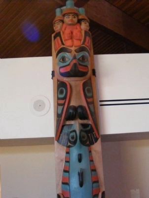
Raven is the Creator in many Alaska Native and American Indian legends. Elements from my different legends are incorporated into this sculpture including "Raven Stealing the Stars, Sun, and Moon." The human figures in the claws symbolize icons used . . . — — Map (db m72793) HM
For generations the Inuit people of Northern Canada, Greenland, and Alaska have constructed these rock monuments for hunting and navigational purposes. Our inuksuk is a giant version based on similar monuments found throughout the Arctic. . . . — — Map (db m69768) HM
High above river valleys, at overlooks like this, Denali’s first human visitors watch for mammoth, giant bison, and caribou. Ridge tops made the best game launching platforms; herds tend to follow sheltered stream corridors.
Hunters had to . . . — — Map (db m69724) HM
Natives of Southeast Alaska have made totem poles such as this one for thousands of years.
This pole depicts four Haida clan stories. It was carved in 1940 by master carver John Wallace of Hydaburg. Described as "the last of the professional . . . — — Map (db m181736) HM
Monument against east wall of house off Whittier Way:
This memorial is dedicated to all
Alaska Native Veterans,
Southeast who served in the
United States Armed Forces. Let us not dwell on their passing
but remember their . . . — — Map (db m69127) WM
Because Juneau cannot be reached by road, the waterfront has always been Juneau's doorway to the outside world. Today travelers and freight continue to arrive at this waterfront by sea and air.
The first vessels on the Gastineau Channel were the . . . — — Map (db m181775) HM
This totem pole tells the story of the harnessing of the atom. The pole was carved in 1967 by Tlingit carver Amos Wallace of Juneau. His Tlingit name was Jeet Yaaw Dustaa of the T'akdeintaan Clan of the X'áakw Hít Tlingit (Freshwater-marked Coho . . . — — Map (db m181737) HM
Fifty years after Patsy Ann met her last ship, admirers led by June Dawson organized the Friends of Patsy Ann. The group raised funds and commissioned a statue so Patsy Ann could once again greet visitors on the dock.
Sculpted by Ann Burke . . . — — Map (db m69663) HM
Visionary
An ardent expansionist, Seward pursued his vision of “Manifest Destiny” to expand the borders of the United States through peaceful means. Some of his interests included a port in the Caribbean, Hawaii, Guam, British Columbia, and . . . — — Map (db m181745) HM
Carved by Tlingit carvers:
Charlic Tagook — Klukwan
William Brown — Saxman
Carving began in 1939 / Carving was completed in 1940
Featured on this totem pole, from top to bottom, are Raven, a man, a giant cannibal (Guteel), . . . — — Map (db m181740) HM
The cultural traditions and stylistic glories of Northwest Coast Native artists go back centuries. But the historical period of (obscured) and curating — mainly by non-Natives — is relatively short. Totem poles by tradition were private . . . — — Map (db m182030) HM
Totem poles are carved to honor deceased ancestors, record history, social events, and oral tradition. They were never worshipped as religious objects.
This totem, carved by Israel Shotridge and raised in 1989, is a replica of the Chief . . . — — Map (db m79703) HM
Totem poles are carved to honor deceased ancestors record history, social events, and oral tradition. They were never worshipped as religious objects.
This totem is the second replication of the Chief Kyan Totem Pole. The original pole was . . . — — Map (db m70746) HM
The Christian cross was planted in Ketchikan's shoreline in 1897, when the settlement was only a creekside collection of Native homes and a trading site for the first white businessman in the area. The missionary priest who staked an ecclesiastical . . . — — Map (db m182004) HM
The Revenue Cutter McCulloch is docked near Northern Machine Works (left) and a Japanese barkentine is at anchor on the south end of the wharf near the Ketchikan Spruce Mills (right) to purchase fish. Also visible is St. John's Episcopal . . . — — Map (db m181984) HM
For thousands of years, water has been the common highway for all Northwest Coast Natives. Living at the edge of dense rain forests of great cedar, spruce, and hemlock along one of the world's richest sea coasts, their dependence upon seafood . . . — — Map (db m181977) HM
A city arose at the mouth of Ketchikan Creek early in the 20th century, where Native people had camped for uncountable centuries to fish and hunt, houses, stores, hotels and sawmills uprooted the rainforest skyline in a sort of land-rush flurry of . . . — — Map (db m182027) HM
“Thundering Wings” — the title of local master carver Nathan Jackson's magnificent cedar monument, depicts the Tlingit native origin of Ketchikan's name, as told by Chief Reynold Denny of the Beaver Clan:
“About three hundred years ago the . . . — — Map (db m181908) HM
The following 72 Inupiat Eskimos are interred in this common grave. Pray, honor and remember these villagers, who lost their lives during the short span of five days, in the influenza pandemic, November 15-20, 1918.
Abeyorok, Mike, 26 • . . . — — Map (db m149930) HM
Sharing Food, Sharing Life – Then and Now
Ukpiaġvik, which means ‘the place where we hunt snowy owls,’ was one of several ancient villages in the Barrow area. Our ancestors settled here primarily to hunt the great bowhead whales. But . . . — — Map (db m49595) HM
This site possesses national significance in commemorating the history of the United States of America. The hall is the place of importance in the native community. The original chapter of Alaska Native Brotherhood built this hall in 1914 to serve . . . — — Map (db m133827) HM
Russians and Native Alaskans took the first tentative steps toward mutual understanding in the Russian Bishop's House. The bishop lived here alongside Tlingit students and Native and Kryol (mixed ancestry) men studying to become Orthodox priests. . . . — — Map (db m181607) HM
Blacksmiths and artisans who once lived and toiled on this hill were highly skilled workers of diverse ethnicities. Artifacts found here tell their forgotten story.
Under Your Feet
In 1997, archaeologists discovered Russian workshops . . . — — Map (db m181266) HM
When the Kiksadi clan of the Tlingit Indians first migrated into this area from the south, they chose this promontory for the erection of their main houses. There were four of these community houses here when Baranof, governor of the . . . — — Map (db m181334) HM
Baranof and his party landed and parleyed with the Kiksadi who refused to permit another settlement. When the Russians attacked this hill they found the Kiksadi had moved to their fort ¼ mile east on Indian River.
After the battle and siege at . . . — — Map (db m181343) HM
Tlingit people established ties to this place long ago and those ties, though altered, remain.
The Land and the Tlingit
The ocean and the forest met the Tlingit peoples' needs as they moved from summer fish camps to autumn hunting grounds . . . — — Map (db m181331) HM
Saint Michael's Cathedral, a National Historic Landmark, is the central point of interest in historic downtown Sitka and is recognizable statewide as the most prominent symbol of the Russian colonial presence in Alaska. It was the main edifice of a . . . — — Map (db m181574) HM
Norman E. Staton Sr. and Ethel L. (Milonich) Staton, lifelong Alaskans moved from Ketchikan to Sitka in 1955 opening their first restaurant, the Pioneer Grill on Katlian Street and their second, the Sitka Café on Lincoln Street before opening . . . — — Map (db m181259) HM
Skagway was originally spelled S-K-A-G-U-A, a Tlingit Indian word for “windy place.” The first people in the area were Tlingits from the Chilkoot and Chilkat villages in the Haines-Klukwan area. From a fish camp in nearby Dyea, they used the . . . — — Map (db m69128) HM
Widely used today on the Yukon and Copper Rivers, the fishwheel was introduced in Alaska near the turn of the 20th century. It is thought to have been prominent in the Pacific Northwest, particularly the Columbia River, prior to making its way to . . . — — Map (db m173903) HM