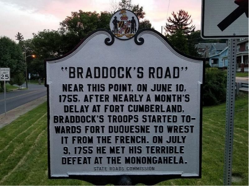
Near this point, on June 10, 1755, after nearly a month's delay at Fort Cumberland, Braddock's troops started towards Fort Duquesne to wrest it from the French. On July 9, 1755, he met his terrible defeat at the Monongahela. — — Map (db m155433) HM
Fort Cumberland was garrisoned from 1754 to 1765. During this period, there was bickering between Maryland and Virginia as to how the fort should be maintained and whose control it was under.
In early 1756, Colonel Washington favored a small . . . — — Map (db m17708) HM
West of this bridge, now the site of Emmanuel Church, was located Fort Cumberland, whence, in, 1755, the expedition against Fort Duquesne was led by General Edward Braddock and Colonel George Washington.
On this site were located wooden . . . — — Map (db m139108) HM
In Memory of Col. Thomas Cresap Pathfinder - Pioneer - Patriot - Built the first home and fort in this county at Oldtown, about 1740 Surveyed the first trail to the west, starting near this spot in 1751 His Sons - - - Daniel Cresap for whom . . . — — Map (db m17778) HM
In 1749 Christopher Gist, an agent for the Ohio Company, arrived at the junction of the Wills Creek and the North Branch of the Potomac River to erect a trading post. In anticipation of the French and Indian War a fort was constructed in 1754 . . . — — Map (db m139113) HM
Horatio Sharpe Lived: 1718-1790. Here as Governor of Maryland and the commander of the fort. Fort Frederick was built by his direction. Governor: 1753-1769. Sharpsburg, Md., was named in his honor. Daniel Boone Lived: 1734-1820. Here as a . . . — — Map (db m17681) HM
Our founding father spent much time in this vicinity when a young man as surveyor, ambassador, aide-de-camp to General Braddock, and commander of Virginia military forces. This cabin served as his headquarters during part of this time.
Young . . . — — Map (db m167057) HM
As colonel under General Braddock at Fort Cumberland during the French and Indian War 1755 - 1758 and as Commander-in-Chief of the American Army in 1794Presented to the City of Cumberland by James Walter Thomas, L.L.D.; Litt.D. dedicated April . . . — — Map (db m17724) HM
Indians served on both sides during the French and Indian War. Some tribes seemed to switch loyalties during the war, when it better suited their purposes. Indians camped near here to consult with General Braddock just before his fateful . . . — — Map (db m139102) HM
Jane Frazier
wife of
Lieut. John Frazier
was captured by Indians near this spot in October 1755 and taken to the Miami River. She escaped after eighteen months and made her way back to her home. — — Map (db m402) HM
Fort Cumberland grew out of the efforts of The Ohio Company to speculate in land and establish a fur trade with the Indians between here and the Ohio Valley and the efforts of the British government to enforce land claims in these areas.
The . . . — — Map (db m139107) HM
The land west of the Allegheny Mountains was exclusively the Indians until the mid 1700's. The local Indians were part of the Shawanese tribe and a sub-division of the Algonquin Nation-one of the most warlike. With the coming of the white man, . . . — — Map (db m167128) HM
You stand upon historic ground within the north wall of Fort Cumberland. Your location (X) is shown on the diagram. Lines of barracks (I), parallel with the street, were to your front and in the rear along the line of white rocks in the street. The . . . — — Map (db m167129) HM
Center Plaque
On October 16, 1794, President George Washington arrived in Cumberland to review about 5,000 troops of the Maryland and Virginia militia gathered here during th Whiskey Rebellion. A few days later, this militia army assembled upon . . . — — Map (db m17456) HM
The store houses of The Ohio Company were first located near this point. In 1754 the first fort (called Mt. Pleasant) was built. Gen'l. Edward Braddock enlarged the fort in 1755 and renamed it after his friend the Duke of Cumberland. — — Map (db m167130) HM
You stand near the wall of one of Fort Cumberland's four bastions. These (+) an your position (X) are indicated on the fort diagram. A bastion is a projecting portion of a fortification. It's purpose is to allow defenders added firepower along the . . . — — Map (db m139103) HM
The fort proper was the bastioned work at the west end of the fort. It was to your left (primarily on the site of the Church of Christ Scientist). Besides the four bastions (b) and the joining walls, there were four buildings for provisions (6), two . . . — — Map (db m167356) HM
The Narrows is a 1000-foot high natural landmark which cuts through Wills and Haystack Mountains. The pass facilitated commerce, travel and migration between Cumberland and the west.
Early roads bypassed the Narrows and followed the Delaware . . . — — Map (db m175915) HM
Here the Indian envoys were received before Braddock left for his defeat. In 1756-58 the garrison under Col. Washington was still reviewed here. — — Map (db m17453) HM
Which was built in 1755 by order of the British Government and named in honor of the Duke of Cumberland, Captain General of the British Army. It was the base of military operations of General Edward Braddock and Colonel George Washington in the . . . — — Map (db m18733) HM
By order of Colonel Bouquet, George Washington’s troops opened this road from Fort Cumberland to Reas-town (Bedford, Pa.) during July 1758. Bouquet and Washington conferred half-way between these places July 30, 1758. — — Map (db m166865) HM
War path of the five nations from central New York to the Carolinas. One of the longest Indian trails in America, crossed this highway about this point. — — Map (db m3489) HM
The Braddock Stone, an early colonial highway marker, is named for British General Edward Braddock (1695—1755). During the early stages of the French and Indian War, General Braddock was dispatched to expel French forces from what is today . . . — — Map (db m135549) HM
Daniel Cresap, pioneer settler, gave his name to Dan's Mountain and Dan's Rock. Born in 1728 near Havre de Grace, MD., son of Colonel Thomas Cresap. Fought in French and Indian War. By first wife, unknown, had one son; by second wife, Ruth . . . — — Map (db m98538) HM
Robert Twigg was the first Twigg to acquire land in what is now Allegany County, Maryland. In 1768 he purchased this land known as "Sink Hole Bottom". On this site, Austin D. Twigg (1863-1941) ran the Twiggtown General Store and Post Office as . . . — — Map (db m144697) HM
Fording place for “Great Warriors Path” from New York to the South. Thomas Cresap built stockade fort here in 1741 used as a refuge during French and Indian War after Braddock’s defeat.
George Washington
was here on his first . . . — — Map (db m447) HM
This site owned by Amos Garrett was surveyed as Lot 46 on James Stoddert's 1718 plan of Annapolis. The Lloyd Dulany family lived here from 1761 until 1783. The group of buildings known successively as Mann's Tavern, City Tavern and the City Hotel . . . — — Map (db m6194) HM
In 1771 when Annapolis merchant Charles Wallace laid out plot lines on Cornhill Street, former ship captain Beriah Maybury leased two plots and built this house which he opened as the King's Arms Tavern in 1773. In 1792 he renamed it the Sign of the . . . — — Map (db m6450) HM
Annapolitans and county residents visited this site for medical care for nearly a century after the founding of the Annapolis Emergency Hospital in 1902. The hospital first purchased the home of former mayor Edwin Seidewitz, part of which probably . . . — — Map (db m114790) HM
The story of historic preservation in Annapolis is one of community involvement. Efforts to protect the historic element of Annapolis extend back to the nineteenth century. In . . . — — Map (db m114793) HM
"And for the support of this Declaration, with a firm Reliance on the Protection of divine Providence, we mutually pledge to each other our Lives, our Fortunes, and our sacred Honor."
With these ringing words of resolve, . . . — — Map (db m114543) HM
In the decades before the American Revolution, Annapolis was the customs port for the upper Bay western shore. Ships clearing in and out paid duties and fees to the local naval officer. With good shipyards (including Ship Carpenters Lot north of the . . . — — Map (db m19288) HM
Annapolis Charter 300, the city wide commemoration in 2008 of the 1708 city charter granted during Queen Anne's reign, was especially rich in inspiring original public art, music and choral work, a ballet suite, films, sculpture, photography, . . . — — Map (db m114546) HM
On March 25, 1655, colonial Governor William Stone landed Maryland militia at the Puritan settlement of Providence, located at the mouth of the Severn River. He planned to subdue the settlers who had asserted their independence from the government . . . — — Map (db m53178) HM
Near this spot
which was then the shore of the bay,
the Brig “Peggy Stewart” was burned
by her owner, “Anthony Stewart.”
October 19, 1774
To pacify the indignation of the
citizens roused by the payment of . . . — — Map (db m6313) HM
The porch you see before you is a modern reconstruction of this principal entrance to the Carroll House. It was added to the house in the 1770s by Charles Carroll of Carrolton and removed by 1866 when a two story passage was built between St. Mary's . . . — — Map (db m175948) HM
Patriot politician and future Declaration of Independence signer Samuel Chase began building this Georgian mansion in 1769, but he couldn't afford to finish the house and sold it two years later to Edward Lloyd IV. The wealthy Eastern Shore . . . — — Map (db m63497) HM
Has been designated a Registered National Historic Landmark Under the provisions of the Historic Sites Act of August 21, 1935. This site possesses exceptional value in commemorating or illustrating the history of the United States U.S. . . . — — Map (db m6199) HM
The oldest surviving map of Annapolis, drawn by James Stoddert in 1718, shows that the area now occupied by Corhill and Fleet Streets, had been set aside for Governor Francis Nocholson for use as a garden, summer house and vineyard. In 1771 Charles . . . — — Map (db m17689) HM
Beyond Main Street: As you travel up Main Street from the City Dock, looking up from Francis Street to your right you see one of the iconic views of Annapolis—the Maryland State House. Built in the late 18th century atop the hill crowned by State . . . — — Map (db m114552) HM
The first English settlers were a group of Puritans who established Providence, a settlement at the mouth of the Severn River, in 1649. The Puritans probably used Captain John Smith's Bay map to navigate here from Virginia. Their settlement was not . . . — — Map (db m114869) HM
The brigantine Peggy Stewart, named after the daughter of the owner, Annapolis merchant Anthony Stewart, sailed by here on her return from England on October 14, 1774. Like other Maryland merchants, Stewart had agreed not to import tea in . . . — — Map (db m170220) HM
Look around the harbor. Imagine what the first colonists saw more than 350 years ago when they first viewed this Chesapeake Bay peninsula: a pristine, abundant natural site with deep, protected harbors that had experienced little human settlement. . . . — — Map (db m19266) HM
Francis Street is named for Sir Francis Nicholson (1655-1728), royal governor of Maryland, who served from 1694 to 1698. When the capital of the colony moved from St. Mary's City to Annapolis, Nicholson devised the city's baroque plan featuring two . . . — — Map (db m114797) HM
Bloomsbury Square was named after a square in London where the Lords Baltimore, proprietors (owners) of Maryland, lived and where prospective settlers went in 1633 to get information concerning the proposed new colony of Maryland. Bloomsbury Square . . . — — Map (db m5419) HM
Designed and built for legislator and patriot, Mathias Hammond by the colonial architect, William Buckland, this beautiful residence is considered the pinnacle of the Georgian Style in America.
A museum today, the house is almost entirely . . . — — Map (db m7898) HM
Tours start at the top of the hour from noon until 4:00 (summer) or 3:00 (winter).
Built in 1774 by renowned architect William Buckland for tobacco planter and patriot Matthias Hammond, the house is one of the finest examples of . . . — — Map (db m142372) HM
Design
The black and gold design on the flag is the coat of arms from the Calvert line. It was granted to George Calvert as a reward for his storming a fortification during a battle. The red and white design is the coat of arms of the . . . — — Map (db m114857) HM
This granite block was dedicated as the cornerstone of a proposed fountain on 22 November 1908, the 200th anniversary of the Annapolis City Charter. The fountain was planned to commemorate the 1649 "Act Concerning Religion," known as the "Act of . . . — — Map (db m6386) HM
The Memorial commemorates the arrival in Annapolis of Kunte Kinte, Alex Haley’s ancestor, as told in his book, Roots. That arrival was not a voluntary one. Kunte Kinte was one among one hundred-forty Africans forced into the hold of the slave . . . — — Map (db m6392) HM
During winter 1988/89, the area known as Lot 70 in James Stoddert’s 1718 survey will be the site of a historical archeological excavation.
In 1718, this lot was owned by Charles Carroll, grandfather of Charles Carroll of Carrollton, who in 1734 . . . — — Map (db m2860) HM
Just north of this building, facing Main Street, stood Mann’s Tavern where twelve delegates from five states met in 1786 to discuss commercial problems of the new nation. Their call for another convention in Philadelphia to render the government . . . — — Map (db m130220) HM
Historic Tavern
Commemorating the role of taverns in the political and social life in our country
Middleton Tavern
Established 1750
Tavern Month, May 1970 — — Map (db m6383) HM
This is the oldest state building in Maryland. It was used by the commissioners for emitting bills of credit from 1730 to 1779; by the Treasurer of the Western Shore from 1779 to 1851; by the Maryland State Treasurer from 1852 to 1903; and has . . . — — Map (db m241674) HM
Francis Nicholson became governor of the province of Maryland in 1694. He was largely responsible for the relocation of Maryland's capital from St. Mary's City to the more centrally located town on the Severn River that he named Annapolis. In . . . — — Map (db m114551) HM
This tablet placed by the
Peggy Stewart Tea Party Chapter
Daughters of
the American Revolution
Annapolis, Maryland
Maryland Day, March 25, 1929 — — Map (db m5428) HM
Annapolis, one of America's earliest chartered cities, celebrated its 300th anniversary of its charter in 2008.
Colonial Governor John Seymour granted the Annapolis municipal charter in the name of England's Queen Anne in 1708, during the . . . — — Map (db m114562) HM
One of the oldest surviving houses in Annapolis, Shiplap House served as a store and tavern in the eighteenth century. The house is named for the random-width flush siding (called shiplap) on the rear facade and northeast ell. The building now . . . — — Map (db m17690) HM
All roads leading to this provincial capital, marked AA to guide the traveler, entered the city here beside the city gate house. A wooden fence, enclosing the city, kept out wandering cattle and "men of ill fame." — — Map (db m6190) HM
Francis Asbury, Father of American Methodism, founded a Methodist Society in Annapolis in 1777. They built a meeting house in 1785 within the present grounds of the Naval Academy. In 1789, the “Old Blue Church” moved to this site and . . . — — Map (db m2909) HM
This cannon was brought from England
by the first settlers March 25, 1634
Mounted on the walls of the fort
at Old St. Mary's
Recovered from the St. Mary's River 1822
Presented to the state in 1840
by Rev. Joseph Carbery
This tablet is . . . — — Map (db m7151) HM
This square is named to commemorate the 200th anniversary on December 12, 1978, of the Court of Appeals of Maryland, the state’s highest court. It encompasses Lawyers Street, shown on the earliest map of Annapolis (1718) connecting Publick Circle . . . — — Map (db m2862) HM
Sy Mohr's City Dock Harbormaster Collage speaks to the magical landscape that welcomes citizens and visitors alike to the City Dock and the historical City of Annapolis. His work takes us on a trip through time, progressively moving from the past in . . . — — Map (db m114802) HM
Birthplace of Charles Carroll of Carrollton (September 19, 1737 – November 14, 1832), the only Roman Catholic to sign the Declaration of Independence and the last of the signers to die.
Charles Carroll of Annapolis (1702 – 1782), . . . — — Map (db m55298) HM
During the second half of the 18th century, shoemaker Allen Quynn owned or leased a large portion of both sides of the first block of West Street. At one time this building was Quynn's home, but in 1767 Quynn leased the house to watchmaker William . . . — — Map (db m75681) HM
The 1718 Stoddert survey map indicates William Bladen as the first recorded owner of lot 42. Charles Carroll purchased the property in 1725 and may have been responsible for the construction of the original side hall, double parlor plan when he and . . . — — Map (db m75719) HM
In 1712, Philemon Lloyd of a prominent family of the Maryland Eastern Shore, had a lot surveyed for him which was to be used by the drummer of the town. The drummer, an alternative to the town crier, was unique in Maryland. His duties were to convey . . . — — Map (db m5422) HM
The Old Treasury Building was built by Patrick Creagh in 1735-36 for the Commissioners for Emitting Bills of Credit who issued the first paper money of the colony. Known in the colonial period as the Paper Currency Office, and the Loan Office, . . . — — Map (db m126271) HM
The Old Treasury
The Old Treasury was built between 1735 and 1737 as the office for the Commissioners for Emitting Bills of Credit. The Commissioners were responsible for lending Maryland's newly-authorized paper currency to the colonists. . . . — — Map (db m157077) HM
Built about 1680 The dwelling house of Mr. Jonas Green Printer to this province 1738 - 1767 Printer and publisher of the Maryland Gazette, 1745 - 1767 Flag Day, June 14, 1932 — — Map (db m75718) HM
Erected by the Peggy Stewart Tea Part Chapter, D.A.R., Marks the building in which Gen. Washington was entertained at dinner by the Congress of the United States on the 20th of December, 1783, when he came to Annapolis to resign his commission as . . . — — Map (db m6198) HM
"...two Ferry boats were procured...we made the mouth of the Severn River but the ignorance of the People on board, with respect to the navigation of it run us aground first on Greenbury Point from whence with much exertion and difficulty we got . . . — — Map (db m19289) HM
Built 1774 by Matthias Hammond, local patriot
Designed by William Buckland, Colonial Architect
18th Century furnishings
One of America's famous houses
Open to the public — — Map (db m127929) HM
Formerly an Indian trail to cross South River. In early colonial times it became a principle thoroughfare connecting Annapolis with southern Maryland and Virginia. George Washington remarked on the beautiful roses that still flourish there. — — Map (db m9287) HM
During the Revolutionary War, 1200 Continental Light Infantrymen under the command of Marquis de Lafayette encamped on the rise behind this sign en route to the decisive battle in Yorktown, Va. They arrived in Annapolis from Head of Elk by a . . . — — Map (db m2907) HM
JONAS and ANNE CATHERINE GREEN served successfully as Printer to the Province and publisher of The Maryland Gazette for many years before the start of the American Revolution. Jonas (1712-1767) descended from a family of New England . . . — — Map (db m221728) HM
In 1649, a group of "non-conformist" Puritans landed on the shores of Whitehall Bay, fleeing religious persecution in Virginia and seeking new opportunities in Lord Baltimore's colony of Maryland. These devout Protestants took up land that had been . . . — — Map (db m221301) HM
To Edward, Joshua, and John Dorsey, sons of Edward Dorsey who settled in Maryland in 1650. The patent was signed by Charles Calvert, then Lieutenant General, and later Third Lord Baltimore. This plantation has been the homestead of the Dorseys for . . . — — Map (db m2906) HM
Across the road stood the three mile oak under which General George Washington passed on his way to Annapolis December 19, 1783 to resign his commission as Commander in Chief of the Continental Armies. According to tradition, General Smallwood, . . . — — Map (db m76022) HM
Upper Plaque: This oak tree planted in 1967 perpetuates the memory of the original Three Mile Oak which stood nearby as explained in the marker below.
Lower Plaque: Trunk of the Three Mile Oak Under this tree passed General George . . . — — Map (db m2877) HM
This tablet was fixed on McDowell Hall in 1946 to commemorate the two hundred and fiftieth anniversary of the founding of King William's School. To this hall in 1785, in the second year of the foundation of St. John's College, came the . . . — — Map (db m5423) HM
This tablet is placed upon the Liberty Tree by the Peggy Stewart Tea Party Chapter Daughters of the American Revolution of Annapolis, Maryland, October 19, 1907 to commemorate the first treaty made here with the . . . — — Map (db m241906) HM
This monument honors unknown French soldiers and sailors who gave their lives in the American War of Independence and were buried near here.
Dedicated by President Williams Howard Taft, April 18, 1911
"Our soldiers rest in hallowed . . . — — Map (db m9277) HM
St. John's College has a long, rich history dating back to the founding of our nation. Its earliest incarnation, a grammar or preparatory school named after King William III, was founded in Annapolis in 1696, one year after Maryland's capital was . . . — — Map (db m63410) HM
The birthplace of Charles Carroll, Barrister, 1723 - 1783, colonial patriot and author of Maryland Bill of Rights. Built in 1722 by his father, Dr. Charles Carroll, Chirurgeon. Moved from its original location at Main and Conduit Streets through . . . — — Map (db m5420) HM
French troops under Count de Rochambeau made their 36th camp here September 16-17, 1781, enroute to Yorktown, Virginia. Most of the troops embarked from Annapolis, but the artillary marched to Georgetown to cross the Potomac River. — — Map (db m2928) HM
Count de Rochambeau’s troops marched over this road from Spurrier’s Tavern to “Scott’s Plantation” (Belvoir) on Sept. 16, 1781 on the way to Yorktown. Washington and Rochambeau had gone ahead Sept. 10–11 on the way to Mt. Vernon. — — Map (db m2890) HM
Near this spot lies buried Henry Baldwin officer and engineer in the Revolutionary War 1777–1783. Charter member of the Society of the Cincinnati. Born Dec. 23, 1753 – Died Oct 15, 1793, at Rising Sun, Anne Arundel Co., Maryland. — — Map (db m2879) HM
Near here, at the end of Eastern Avenue, is the site of one of three forts built to defend Annapolis Harbor from British raids during the Revolutionary War.
Built in 1776, the fort had major defenses of trenches, earthen ramparts and fifteen . . . — — Map (db m173597) HM
[photo of plants and tools] Early medicinal plants and tools
Colonial Medicine Chest
Where did the colonial doctor or housewife turn when they needed to treat the sick? The plants of the field, hedgerow and marsh were their pharmacy. . . . — — Map (db m22138) HM
Scattered Settlements
Early Chesapeake Bay colonists did not settle in the concentrated villages typical of their home in England. Instead, they lived on large plots of waterfront land that isolated them from their neighbors.
Cheap and . . . — — Map (db m22112) HM
[map of colonial Maryland] Detail from The State of Maryland, Samuel Lewis, 1795. Showing London Town, Annapolis and Baltimore.
Welcome
Historic London Town and Gardens is a 23-acre park where discover and learning are daily . . . — — Map (db m22140) HM
Native American Exhibit 250 yards, a 5 minute walk
Java Plantation Exhibit .5 mile, a 25 minute walk
Java Dairy Exhibits .75 mile, a 55 minute walk
Java’ Return to Nature Exhibits 1 mile, a 70 minute walk
Indians of the Chesapeake For . . . — — Map (db m80874) HM
Since the 1700s there has been a road leading to Contee's Wharf. Deep water and the protection provided by Big Island made it a natural port. The river has served as a vital link between area residents and the outside world. The wharf was the center . . . — — Map (db m80858) HM
The increase in tobacco production was closely linked with the economic growth of America. Tobacco was so popular that it was used as money. Maryland had a suitable climate for its production, so the area thrived. The Java Plantation, like other . . . — — Map (db m80859) HM
948 entries matched your criteria. The first 100 are listed above. Next 100 ⊳