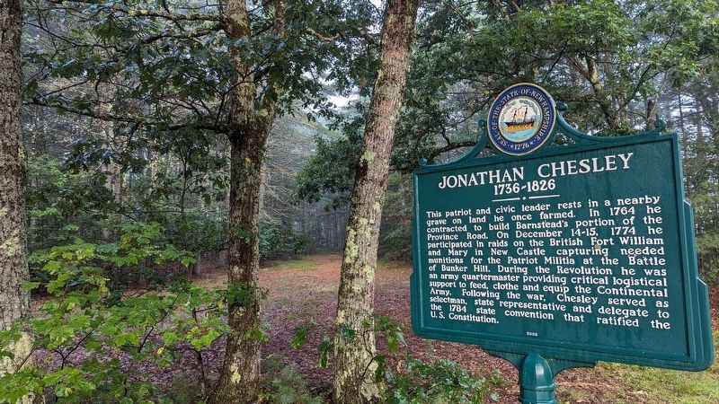
This patriot and civic leader rests in a nearby grave on land he once farmed. In 1764 he contracted to build Barnstead's portion of the Province Road. On December 14-15, 1774 he participated in raids on the British Fort William and Mary in New . . . — — Map (db m235107) HM
One of the earliest highways in New Hampshire, it was authorized in 1765 as a supply route from the tide-water port of Durham to the colony's northern settlements in the Coos. This section of the road through Gilmanton was built in 1770 nine . . . — — Map (db m235104) HM
National Society
Women Descendants
Ancient and Honorable
Artillery Company
Massachusetts
1637 — 1774
Honors Two Charter Members
John Endicott and Edward Johnson
Captain Johnson surveyed
this area in 1652
for the . . . — — Map (db m173402) HM
Endicott Rock
the name of
John Endicvt Gov.
and the initials of
Edward Johnson and Simon Willard, Commissioners
of the Massachusetts Bay Colony,
John Sherman and Jonathan Ince, Surveyors,
were inscribed upon this rock
August . . . — — Map (db m172639) HM
In several versions, the legend’s sequence relates the mysterious death of Chocorua’s son while in the care of a settler named Campbell. Suspicious of the cause, the Pequawket chieftain took revenge on the settler’s family. Then, in retaliation, . . . — — Map (db m152078) HM
In 1771, Timothy Lash of Lancaster and Benjamin Sawyer of Conway made a bargain with Governor John Wentworth to bring a horse through Crawford Notch in order to prove the route’s commercial value. The pair succeeded by dragging and lowering the . . . — — Map (db m239145) HM
Was fought between 1722 and 1725 against several tribes of eastern Indians. The principal campaigns took place in the Ossipee region and led to the eventual withdrawal of the Indians to the north. Commemorated in Colonial literature by “The Ballad . . . — — Map (db m152069) HM
Governor John Wentworth and the King's Council voted in the spring of 1771 that a highway be made from the Governor's estate at Wolfeborough to Dartmouth College.
Joseph Senter, David Copp and Samuel Shepard surveyed the 67-mile road which . . . — — Map (db m234615) HM
In 1772 "the people called Methodist" held their first religious meeting in this state on the James Robertson farm, 1.2 miles north of here, on Christian Street, with Philip Embury as the preacher. On June 20, 1803, Francis Asbury spoke here using . . . — — Map (db m85918) HM
In honor and memory of Brigadier General James Reed Born at Woburn, Mass. Jan. 8, 1723 Died at Fitchburg, Mass. Feb 13, 1807 One of the proprietors of Monadnock No. 4, and a founder of this town. A leader in its civil and religious life. . . . — — Map (db m152116) HM WM
This veteran Captain of the French and Indian War, born in Woburn, Mass., settled here about 1765 as an original proprietor of Monadnock No. 4, now Fitzwilliam. After the Battle of Lexington, he recruited several companies to form the Third New . . . — — Map (db m136527) HM WM
Keene
Remembers
The Colonial Wars
1675 - 1763
Revolutionary War
1775 - 1783
War with England
1812 - 1814
War with Mexico
1846 - 1848
Mexican Expedition
1916 - 1918
World War
1917 - 1918
and its citizens
who . . . — — Map (db m151913) WM
The First Meeting House in Upper Ashuelot, now Keene was built on this knoll in 1736-7. Here also was located the Burying Ground of the original settlers. Erected by Ashuelot Chapter Daughters of the American Revolution in 1913 — — Map (db m59779) HM
Darby Field, a New Hampshire settler, accomplished this difficult feat in 1642 from a southerly approach. Partly guided by Indians and with only primitive equipment at his disposal, he is thus alleged to be the originator of all Mount Washington . . . — — Map (db m77638) HM
Settled in 1766 by Jaasiel Harriman whose cabin was near the Great Rock. His nine year old daughter Mercy carried dirt in her apron to the top of this unique rock formation. Here she planted corn, pumpkins and cucumbers, making the first garden . . . — — Map (db m74569) HM
First known as "Broad Street," this early venture in town planning was laid out in 1788. About a mile in length and beautifully situated, starting about two miles in on next northerly road, the plan provided for an orderly arrangement of . . . — — Map (db m203377) HM
The Enfield Shakers
Founded in 1793, Shaker Village was the 9th of the original Shaker communities established in the U.S. At its peak c.1850 some 300 Shakers lived, worked and worshipped here, practicing equality of the sexes, celibacy, pacifism, . . . — — Map (db m98107) HM
The land you see as you stand here all lies within the township of Lincoln, granted on January 31, 1764 to James Avery and others and named after Henry Clinton, ninth Earl of Lincoln. The original grant contained 32,456 acres. Settlers did not . . . — — Map (db m76422) HM
When North America was first settled, pioneers built their homes of logs. To aid in falling the timber, they made U or V-shaped cuts at the tree’s base. Similar cuts were made in the logs to hold their cabins together. They called these cuts . . . — — Map (db m105988) HM
This is considered to be the site of Colonel John Goffe's log dwelling. In 1744 Goffe build a gristmill on Bowman's Brook, later run by his son, Major John Goffe (1727–1813), and his grandson, Theodore Atkinson Goffe (1769–1860). The . . . — — Map (db m88052) HM
This brass four-pounder, cast in 1743, was captured August 15, 1777 at the Battle of Bennington by Gen. John Stark's troops. Gen. Stark presented "Old Molly" to the New Boston Artillery Company of the 9th Regiment of New Hampshire Militia, for its . . . — — Map (db m225989) HM
TEMPLE GLASS FACTORY
Was located at a secluded site in the southwest portion of Temple township. Founded in 1780 by Robert Hewes who employed Hessian mercenaries from the British Army trained in the art of glass-blowing. This early attempt to . . . — — Map (db m235453) HM
On this site in 1772 stood Aaron Quimby's tavern
where, on the morning of April 14th, Ebenezer
Mudgett and other men from Weare, incensed at their
impending arrest for cutting pine trees greater than
one foot in diameter, in violation of the . . . — — Map (db m230480) HM WM
Famous symbol of frontier heroism.
A victim of an Indian raid in 1697
on Haverhill, Massachusetts, whence
she had been taken to a camp site
on the nearby island in the river.
After killing and later scalping
ten Indians, she and the two . . . — — Map (db m129625) HM
(Front/West side)
Hannah Duston
Mary Neff
Samuel Leonardson
March 30 1697
Mid-night
(Front base of monument)
David Blanchard
W. Concord, N.H.
(Right/South side)
Statua
Know ye that we with many . . . — — Map (db m135432) HM
1741 1820
This tablet marks site of last residence of
Henry Parkinson, A. M.
Nassau Hall, now Princeton University, 1764,
an excellent classical preceptor,
a Patriot of the Revolution.
Regimental Quartermaster under
Colonel . . . — — Map (db m149043) HM WM
Downtown Emerges
Ever since Concord was first settled in 1726, Main Street has been its principal thoroughfare.
The town's first plan shows an unnamed street that follows the same path as today's Main Street.
The 1-1/2 mile route was . . . — — Map (db m115859) HM
On the interval below this spot a committee of the General Court of Massachusetts Bay, their surveyors and attendants there present to locate and survey the Plantation of Penny Cook, conducted the first religious service ever held in the central . . . — — Map (db m129757) HM
The convention of delegates from 175 New Hampshire towns took place on June 21, 1788, in the Old North Meeting House which stood on this site from 1751 until destroyed by fire in 1870. The delegates approved the proposed Federal Constitution by . . . — — Map (db m130008) HM
Site of
First Ferry
Established by
Capt. Ebenezer Eastman
1727.
--------------
Tucker's Ferry
1785.
--------------
Federal Bridge
1798. — — Map (db m129801) HM
Around this house was erected in 1746 the first stated garrison in Concord to protect from the French and Indian enemy the families of Rev. Timothy Walker, Capt. John Chandler, Abraham Bradley, Samuel Bradley, John Webster, Nathaniel Rolf, Joseph . . . — — Map (db m115939) HM
When Europeans settled in New England in the
1620s, the largest Native American tribal group
in the future state of New Hampshire used the
flat lands and bends of the Merrimack River in
present Concord for its central village. . . . — — Map (db m130005) HM
This
monument
is in memory of
Samuel Bradley
Jonathan Bradley
Obadiah Peters
John Bean &
John Lufkin
Who were massacred
August 11TH, 1746
By the Indians near
This spot
~
Erected 1837
By Richard Bradley
Son of the Hon. John Bradley,
& . . . — — Map (db m129598) HM
Built by her father, Capt. Caleb Page, c. 1759,
this was Molly Page's home in her youth and
as the wife of Gen. John Stark. Their first
son, Caleb, who served with his illustrious
father during the Revolution, was born here,
as was Molly''s . . . — — Map (db m130082) HM
Daniel Webster was born here January 18, 1782.
Statesman and lawyer, he served as U.S. Congressman
from New Hampshire and Massachusetts,
Senator from Massachusetts and Secretary of
State under Presidents Harrison, Tyler and
Fillmore. A noted . . . — — Map (db m131051) HM
Near the site of this boulder stood the log cabin built by Philip Call first White settler of Franklin, N.H.
Sarah Trussel his wife was killed here by the Indians on August 15, 1754
Tablet placed by Abigail Webster Chapter D.A.R. 1928 — — Map (db m148364) HM
This is the site of the first meeting house in
Suncook, incorporated as Pembroke in 1759.
Granted to soldiers in Lovewell's Indian War
(1722-25) or their survivors, the land was
largely settled by Congregationalists from
Massachusetts Bay. . . . — — Map (db m131384) HM
The Chester Congregational Church
Built in 1773
Entered in the National
Register of Historic Places
Washington, D.C.
June 5, 1986 — — Map (db m159916) HM
Born in Andover, Mass. June 21, 1736, Enoch Poor settled in Exeter, becoming a successful merchant and ship-builder. In 1775 he was appointed colonel in the 3rd New Hampshire Regiment. Poor was at Stillwater, Saratoga and Monmouth, and served under . . . — — Map (db m75241) HM
In honor of John Folsom and his wife Mary Gilman, progenitors of the American Folsoms, natives of Hingham, England emigrated 1638, settled Exeter 1655. This stone erected by their descendants on land granted to Lieutenant Peter Folsom, was once the . . . — — Map (db m96467) HM
The historic Town House of Exeter stood near this site. Here on January 5, 1776, the Provincial Congress adopted and signed the first state constitution thereby establishing an independent state government, the first of the thirteen colonies. The . . . — — Map (db m75242) HM
Built about 1721 as one of New Hampshire’s earliest brick houses, and enlarged and clapboarded in the 1750s, this dwelling served as the state treasury during the Revolution. Here were born John Taylor Gilman (1753-1828), who was elected governor . . . — — Map (db m75243) HM
At this site on the Squamscott river stands the storehouse for the town’s powder used during the American Revolution and the War of 1812. Powder captured from the British at New Castle was stored here and later used at the Battle of Bunker Hill. — — Map (db m41157) HM
Directly across the Squamscott river stands the storehouse for the towns powder used during the American Revolution and the War of 1812. Powder captured from the British at New Castle was stored here and later used at the Battle of Bunker Hill. — — Map (db m41158) HM
Founded by Rev. John Wheelwright in 1638, Exeter was one of the four original towns in the colony. Following New Hampshire’s provisional declaration of independence on January 5, 1776, it served as the capital of the new state during the period of . . . — — Map (db m75244) HM
Second Burial Ground Est. late 1600's Here is the last resting place of some of Exeter's early settlers. Samuel Dudley, respected minister who led Exeter's residents for 33 years. Nathaniel Ladd and family, influential community members, built the . . . — — Map (db m96466) HM
A grist mill built by Thomas Wilson in 1640. The island and site were granted to him by the town which reserved the right for canoe landing and the laying of fish. Wilson’s Creek flows on the easterly side. — — Map (db m41156) HM
(side 1)
Historic Black Rocks Village
Settled in the 1720's this section of Poplin, (now Fremont) between Scribner Road & Rowe's Gas Station at 225 Main Street, gradually grew into a thriving settlement called "Black Rocks . . . — — Map (db m115780) HM
This old Inn/Tavern is one of the most historic landmarks in Fremont.
The first Poplin (now Fremont) Town Meeting was held here at Lovering's Inn on August 27, 1764, as were many other Town Meetings.
The towns' name was changed from Poplin . . . — — Map (db m115814) HM
Local lumbermen illegally cut Mast Trees reserved for the King's Royal Navy.
When David Dunbar, Surveyor General, visited nearby Copyhold Mill to inspect fallen lumber, local citizens assembled, discharged firearms and convinced Dunbar to . . . — — Map (db m115793) HM
In the year 1675, John Johnson was granted a tavern keeper's license. He resided and operated the tavern where the roads meet from Portsmouth, Exeter, and Hampton, at today's 480 Portsmouth Avenue. This is the house immediately in front of you. . . . — — Map (db m186250) HM
First Public School in New Hampshire, supported by taxation, was opened in Hampton on May 31, 1649. It was presided over by John Legat for the education of both sexes. The sole qualification for admission of the pupils was that they be “capable of . . . — — Map (db m105144) HM
Distinguished participant in the founding of the Republic as signer of the Declaration of Independence and Articles of Confederation, and prominent in this State as Chief Justice of two courts and first holder of the title of Governor. An innovator . . . — — Map (db m75245) HM
The Frost Cemetery was a private family burying ground passed down through the Frost and Bell families for many generations. The families lived near the Piscataqua River and the cemetery was located at the end of their properties near the . . . — — Map (db m135323) HM
Site of
Bloody Point Ferry
Operated By
Thomas Trickey
1640 - 1675
Zachariah Trickey
1675 - 1705
John Knight
1705 - 1725
Continued for more than a century by
Capt. Howard Henderson, Sr.
Capt. Howard Henderson, Jr.
Thomas . . . — — Map (db m224510) HM
Boundary disputes among the early river
settlements caused this area to be called
Bloody Point. By 1640 Trickey's Ferry
operated between Bloody Point and Hilton's
Point in Dover. In 1712 the meeting house was erected and the parish set off, . . . — — Map (db m224489) HM
One of the earliest students at Governor Dummer Academy in Massachusetts, Cheswill was among Newmarket’s best-educated and most prosperous citizens. He was entrusted with many offices, including justice of the peace, selectman, town clerk, . . . — — Map (db m113341) HM
The Town of Nottingham was created by a Royal Charter in 1722. A plan of the town was completed in 1724; at that time the design of the Nottingham Square was laid out with house lots and the intersecting streets Bow, Fish, King and North. The . . . — — Map (db m235102) HM
(left panel)
I stand for the Ancestors Here and Beyond
I stand for those who feel anger
I stand for those who were treated unjustly
I stand for those who were taken from their loved ones
I stand for those who suffered . . . — — Map (db m115995) HM
People of African origin or descent have been part of Portsmouth since at least 1645.
This waterfront was an entry port for enslaved people arriving in New Hampshire during the 1600s and 1700s.
Ships brought black children and adults directly . . . — — Map (db m233865) HM
Moffatt - Ladd House & Garden This tree was planted in 1776 when William Whipple (1730 – 1785) returned home from Philadelphia after signing The Declaration of Independence. — — Map (db m105538) HM
In 1717 Portsmouth's first identified black family was baptised by South Church.
Baptisms of enslaved people became more frequent in local churches; black marriages, however, were not included in town records until the Revolutionary Era, when . . . — — Map (db m115979) HM
Legend Records "Liberty, Property & no Stamps" on a flag flown on the first Portsmouth Liberty Pole in January 1766, in response to British attempts to tax products without American representation in Parliament, the Portsmouth Sons of Liberty . . . — — Map (db m76579) HM
The Oracle House is one of the oldest houses in New England. it was built by the Honorable Richard Wibird, an officer in the British Royal Navy, wealthy merchant, member of The King's Council and a benefactor of Harvard College. — — Map (db m23380) HM
This cemetery was formally established in 1671 on land given to the town by Captain John Pickering. The land was used for burials prior to this time, but because Pickering retained the right to graze his cattle here, many of the earliest . . . — — Map (db m76582) HM
In colonial Portsmouth, segregation applied in death as in life. City officials approved a plan in 1705 that set aside this city block for a "Negro Burying Ground." It was close to town, but pushed to what was then its outer edge. By 1813, houses . . . — — Map (db m115977) HM
Located in Market Square Seat of Colonial Government, 1758 - 1776 The Declaration of Independence was read from the Building, July 18, 1776 President George Washington spoke from the Balcony, October 31, 1789 — — Map (db m76461) HM
About six miles offshore, these nine rocky islands served Europeans as a fishing station before the first mainland settlements were made in 1623. Capt. John Smith (1580-1631) named the group "Smiths Isles" in 1614. The codfish that "shoaled" or . . . — — Map (db m165413) HM
This rock, originally in the middle of Hampton River, indicated the start of the boundary line surveyed by Capt. Nicholas Shapley and marked by him AD 1657-HB and SH to determine the line between Hampton and Salisbury. HB meaning. Hampton Bound and . . . — — Map (db m223644) HM
Based on the 1640 southern boundary of Bachiler's farm, it was surveyed by Capt. Nicholas Shapley in 1657, dividing the Province of New Hampshire from the Massachusetts Bay Colony 1689-1741.
In 1662 three Quaker women, being banished from the . . . — — Map (db m115419) HM
The reinterred graves of two members of the Balch Household are in Pine Grove Cemetery. Rev. Benjamin Balch (1743-1815) was the first chaplain of the Continental Navy and earned the title of “Fighting Parson,” then served as the pastor of the local . . . — — Map (db m235105) HM
Dover’s early settlers lived in relative peace with the local Pennacook tribe, learning hunting, fishing, and farming skills from the natives in the early 17th century. Passaconaway, highly respected leader of the Pennacook Confederacy, forged . . . — — Map (db m152213) HM
Noted preacher, educator, naturalist and historian. Born Boston, Mass. Harvard College 1762. School teacher at Portsmouth and Greenland. Pastor of First Congregational Church at nearby Dover, 1766-1786. Published first History of New Hampshire. . . . — — Map (db m224729) HM
New Hampshire lawyer, politician and noted abolitionist, Hale lived in this home for nearly 40 years, until his death. During this time, he was elected to the U.S. Congress as a Democrat in 1842, to the U.S. Senate as an Independent in 1847 and . . . — — Map (db m235894) HM
Revolutionary patriot, soldier, politician, first Grand Master of Masons in New Hampshire, and a resident of Durham. He left the Continental Congress to serve under Washington from Cambridge to Valley Forge. Commanded at Rhode Island in 1778, and . . . — — Map (db m96438) HM
The plaque commemorates the 200th anniversary of the first organized fight of the Revolution and the transport by gundalow of gunpowder taken from the British at Fort William and Mary in New Castle on Dec. 14, 1774, concealed at this spot and . . . — — Map (db m96441) HM
Packer's Falls
These scenic falls, 1.6 miles west of here on the
Lamprey River, once provided waterpower and industry for the early settlers. A deed dated April II, 1694, shows that Capt. Packer, Jonathan Woodman, James Davis, Joseph Meder, and . . . — — Map (db m224730) HM
The New Durham Meetinghouse was built by settlers from Durham and nearby towns in 1770 as their house of worship and seat of government until 1819 when the town's first church was built. This area was the town center until the 1850's when the . . . — — Map (db m96748) HM
Near this place lived David Hamilton of Westburn: born in the parish of Cambuslang, Scotland, in October, 1620; captured by Oliver Cromwell at the Battle of Worcester, England, September 3, 1651; Brought to America as a prisoner in chains on the . . . — — Map (db m243067) HM
Front Panel This American Liberty Elm was named after "The Liberty Tree: Our Country's first Symbol of Freedom." On the morning of August 14, 1765, the people of Boston awakened to discover two effigies suspended from an elm tree in protest . . . — — Map (db m66280) HM