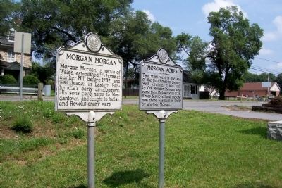
Two miles west is the site of the first house in present West Virginia. It was built by Col. Morgan Morgan who came from Delaware in 1726. It was destroyed and the one now there was built in 1800 by another Morgan. — — Map (db m57717) HM
Nov. 1, 1688 — Nov. 17, 1766. Erected by the State of West Virginia. In commemoration of the first settlement within the present boundaries of said State, which was made by Col. Morgan Morgan, a native of Wales, and Catherine Garretson, his . . . — — Map (db m1169) HM
Originally built 1731-34 as second home of Morgan Morgan-first white settler in West Virginia. Rebuilt with some of original logs in 1976 as a State and County Bicentennial project. It was here during the Revolution that James Morgan, the grandson . . . — — Map (db m12798) HM
At Bunker Hill in 1726, Colonel Morgan Morgan founded the first permanent settlement of record in what is now West Virginia. In commemoration of this event, the state of West Virginia has erected a monument in Bunker Hill State Park, and has . . . — — Map (db m134056) HM
Morgan Morgan, a native of Wales, established his home at Bunker Hill before 1732, and was leader in Eastern Panhandle’s early development. His sons gave name to Morgantown, and fought in Indian and Revolutionary Wars. — — Map (db m1176) HM
By an act of the Virginia House of Burgesses, 1744, a ferry was established extending from the mouth of the Canagochego Creek in Maryland across the Patowmack to the Evan Watkins Landing, about 250 yards southeast. This landing was also the entrance . . . — — Map (db m131795) HM
West Virginia
(Berkeley County)
"The Mountain State"—western part of the Commonwealth of Virginia until June 20, 1863. Settled by the Germans and Scotch-Irish. It became a line of defense between the English and French during . . . — — Map (db m131797) HM
Built by John Hays, 1743. Became home of Reverend David Gerard, who founded Gerrardstown in 1787. His father was Reverend John Gerard, the first Baptist Minister west of the Blue Ridge Mountains. — — Map (db m12793) HM
Established as a town, 1787. Named for John Gerrard, first pastor of Mill Creek Baptist Church, which was organized by early settlers about 1743. The congregation reorganized after Indian hostilities during the French and Indian War. — — Map (db m12791) HM
This property
has been placed on the
National Register
of Historic Places
by the United States
Department of the Interior
Zaquill Morgan House
1761
[Lower plaque:]
A
Berkeley
County
Historic
Landmark . . . — — Map (db m148875) HM
Site of stockade fort built during the early Indian wars. Mt. Zion Episcopal Church was built soon after. A mile west is the tavern, built, 1740–1750, by Robert Snodgrass on land patented in 1732 by William Snodgrass, pioneer settler. — — Map (db m990) HM
Stone House Mansion, predominantly Georgian in style, was constructed in 1757, and is one of the oldest stone structures in Berkeley County. The property is listed in the National Register of Historic Places for its association with the Hite vs. . . . — — Map (db m167518) HM
Adam Stephen (1720-1791) had a close acquaintance with George Washington through their association with Lord Fairfax and from their military involvements from the French & Indian War through the American Revolution. Stephen was present with . . . — — Map (db m167507) HM
During the French and Indian War, Fort Neally was captured and its garrison massacred, Sept. 17, 1756. Many settlers in the vicinity also were killed. Among captives was Isabella Stockton, later wife of William McCleery, Morgantown. — — Map (db m12790) HM
First road constructed in the present Berkeley and Jefferson Counties of West Virginia. Built ca. 1727, it followed the route of an older Indian path that was a branch of the Warrior’s Path. — — Map (db m134052) HM
West Virginia (Berkeley County). "The Mountain State—western part of the Commonwealth of Virginia until June 20, 1863. Settled by the Germans and Scotch-Irish. It became a line of defense between the English and French during . . . — — Map (db m167182) HM
1.5 miles north is Swan Pond Manor, a 2,000 acre retreat set aside in 1745 for use by Thomas, Lord Fairfax, once the proprietor of the Northern Neck of Virginia who established an estate at Greenway Court, Frederick County in 1738. So named because . . . — — Map (db m92579) HM
John Decker built a fort of logs and stone on a site just north of State St. near Ohio River, 1774. Leaden bullets and arrowheads found here on the river bank signify Native American attack on the fort from Mingo Island. — — Map (db m21605) HM
George Washington began a journey on October 5, 1770 to the Ohio Country to see lands he had fought to win and now hoped to own. After a trip, on November 3, up the Kanawha River, the party headed back up the Ohio River. On November 17, they reached . . . — — Map (db m33913) HM
Regular stop on the James River and Kanawha Turnpike. The original building, dating from before the Revolution, was rebuilt by William Tyree, 1810. During the winter of 1861-62, it was headquarters for Chicago Gray Dragoons. — — Map (db m67013) HM
The nearby highway is part of route traversing W.Va. from Lewisburg to Point Pleasant memorialized by the state to commemorate the march of the American Colonial army of 1,200 men led by Andrew & Charles Lewis. After a month's march this army . . . — — Map (db m33809) HM
The proclamation of George III, King of England, in 1763 ordered settlement west of these mountains to stop. The early treaties between the English and the Six Nations accepted this range as the dividing line between them. — — Map (db m75184) HM
Here was the southwestern boundary of the six million acre estate of Lord Fairfax. This vast tract, lying south of the Potomac and known as the Northern Neck, included the Eastern Panhandle and most of the South Branch. — — Map (db m155451) HM
Grant County. Formed in 1866 from Hardy. Named for General Grant, later President. At the northwestern corner is the Fairfax Stone, which established the limits of the lands of Lord Fairfax. The county has many mountain peaks and beautiful . . . — — Map (db m162737) HM
Settled about 1745. Near by was Fort George, Indian fort. Federal trenches overlooked the town in 1863 and 1864. Here is grave of Rev. W. N. Scott, pioneer preacher, who built churches at Old Fields, Moorefield, and Petersburg. — — Map (db m162730) HM
Unknown Soldiers
Six miles west, a Confederate regt. from Georgia camped at Blue Sulphur Springs in improvised shelters, during the winter of 1863. Many died of exposure and disease, and are buried on the hill 400 yards north of the . . . — — Map (db m100004) HM WM
Here at Fort Union, built in 1770, a frontier army of 1100 men assembled in 1774 under command of Gen. Andrew Lewis. On Sept. 12, the army began a march through 160 miles of trackless wilderness to the mouth of the Kanawha River and defeated . . . — — Map (db m75198) HM
"Leave me but a banner to plant upon the mountains of Augusta and I will rally around me the men who will lift our bleeding country from the dust, and set her free."
....Washington . . . — — Map (db m75200) HM
This structure replicates the original fortress stockade, erected nearby in late 1755 by early Cacapehon Valley settler, Joseph Edwards. On his homestead, the fortress encompassed Edwards's house, barn, outbuildings, and a spring. The original . . . — — Map (db m167033) HM
War Comes to the Frontier
It took over one hundred years from the time that European settlers first began to build Jamestown until Governor Spotswood and his Knights of the Golden Horseshoe stood on the Blue Ridge Mountains and gazed . . . — — Map (db m150674) HM
In memory of the soldiers and settlers who lost their lives in Hampshire County during the French and Indian War
Dedicated by the Fort Edwards Foundation June 26, 2004 as part of our commemoration of the founding of Hampshire County . . . — — Map (db m150670) WM
1. A Road to War
When London decided to send Gen. Edward Braddock to the colonies to take over the confrontation with the French, they set in motion events that would lead to a very bloody war on the colonial frontier. Braddock arrived with . . . — — Map (db m167147) HM
“Fort Pearsall was on or in view of this site.”
Job Pearsall built a fort as protection against the indians in 1754 on Lot 16, granted by Fairfax in 1749 containing 323 acres, including part of Indian Mound Cemetary.
On May . . . — — Map (db m2101) HM
The middle of these three structures was built circa 1760 on property owned by Lord Fairfax. It is a two-story, four-room dwelling distinguished by half-timbered construction, a closed stairway, and massive double chimneys, characteristics . . . — — Map (db m150646) HM
Francis Taggart (also spelled Tygart) A Quaker, was responsible for the construction of this Clapboard "Half" House on one of the one hundred lots which Lord Fairfax had surveyed to encourage settlement of the western countries. According to his . . . — — Map (db m150639) HM
Fairfax issued George Wilson a patent for this property in 1763. After Wilson's death, the property passed to his son-in-law Andrew Woodrow, the first clerk of the court of Hampshire Co. after the creation of the U.S. Woodrow then built the front . . . — — Map (db m150648) HM
One of the events which led up to Dunmore's War was the killing at this point of the family of Chief Logan, eloquent leader of the Mingo Indians, April, 1774, opposite their village at the mouth of Yellow Creek in Ohio. — — Map (db m44727) HM
Hardy County. Formed from Hampshire in 1786. Named for distinguished Virginian, Samuel Hardy. In 1725, John Van Meter of New York visited the South Branch Valley. He praised it highly, so his sons acquired land and settled at Old Fields. . . . — — Map (db m237976) HM
Howard's Lick
Howard's Lick, or Lee White Sulphur Springs, was once owned by Gen. Henry "Light Horse Harry" Lee of Revolutionary War fame. It was owned later by Charles Carter Lee, brother of the beloved Gen. Robert E. Lee.
Jackson Home . . . — — Map (db m50470) HM
Built on lands of Issac Van Meter who took up claim near Old Fields, 1735, and settled there, 1744. In chain of forts which Washington established. For a time it was garrisoned by British regulars. Near it was Battle of the Trough, 1756. — — Map (db m155454) HM
George Washington laid off land here for William Wallace Warden, Nov. 11, 1749. Warden built a stockade fort, near which members of his family were killed by Indians, 1758, and the fort burned. Scene of skirmishes in 1862-1863. — — Map (db m237969) HM
The first building known as the Baptist Meeting House stood on this site. The church was organized about 1770 by Rev. John Sutton and five constituent members. Rev. James Sutton served as pastor for a short period. Rev. John Corbly served as pastor . . . — — Map (db m177155) HM
Original site of the Simpson Creek Baptist Church (organized in 1770). Buried here are James "Peg" Clemens, Pony Express rider and cousin of Mark Twain; Joseph Johnson, the only man west of the Alleghenies to serve as governor of Virginia, and . . . — — Map (db m181303) HM
Nearby is the Mclntire blockhouse, built in 1773, another of the outposts established as protection against the Indians. Here are the graves of many
early settlers, including those of John McIntire and wife, both victims of the Indians. — — Map (db m176882) HM
Built, 1778, by Levi Shinn who came from New Jersey, 1773, and claimed tomahawk rights. Returned with family and brothers, Clement and Jonathan and settled. Sold part of land to Jonathan whose son, Levi, deeded it for site of Shinnston. — — Map (db m125817) HM
Inherited by Levi's oldest son Clement. After Clement's death, house sold to David Morris in 1840's. Morris heirs sold it with surrounding land in 1959 to Richardson Lumber & Construction Company. In 1972, its owners, Bob and Shirla (Bice) . . . — — Map (db m177089) HM
Ravenswood. These lands were surveyed, 1771, for George Washington by Colonel William Crawford, who later was taken captive by the Indians and burned at the stake. Washington camped here in 1770. Here is grave of Jesse Hughes, noted scout. . . . — — Map (db m39625) HM
Established in 1832 on land which was settled by William John and Lewis Rogers in 1768 and later acquired by Jacob and Ann (Staats) Starcher. Near here lived Capt. William Parsons who was active in the early life of Jackson County. — — Map (db m73650) HM
You now stand in the center of a town that is almost as old as the United States, laid out on 80 acres of Washington lands in 1786 - four years before the First President took office.
Charles Washington, youngest of the five brothers of the . . . — — Map (db m12600) HM
Explore the Washington Heritage Trail George Washington knew the portion of the Shenandoah Valley that forms West Virginia's Eastern Panhandle well. The Washington Heritage Trail lets you drive the scenic backroads that join Charles Town to . . . — — Map (db m12596) HM
This working farm was established in 1750 when Thomas Lord Fairfax granted 400 acres of his 5 million-acre Northern Neck Proprietary to Henry Lloyd. In 1774, the grant passed to Walter Baker, who is credited with building the original portion of . . . — — Map (db m207034) HM
Erected in 1771. The home of Colonel Samuel Washington, County Lieutenant. His brother General George Washington visited here and General Lafayette and Luis Phillipe of France were entertained here. In this house James Madison and Dolly Payne Todd . . . — — Map (db m1914) HM
Thomas Mayberry agreed in 1742 to erect iron furnaces on the property of William Vestal. Here ore was mined and iron produced for the first time west of the Blue Ridge. Washington visited the iron furnaces here in 1760. — — Map (db m59576) HM
This chapel was built by devout people of (then) Frederick Parish. Frederick County, Virginia joined Col. Robert Worthington in completing it in 1769. It was first called the English Church, then Berkeley Church, then Norborne Chapel, as the parish . . . — — Map (db m2026) HM
Samuel Washington was the brother of George Washington, first President of the United States. Born in 1734, Samuel Washington served as Justice of the Peace, County Magistrate, County Sheriff, and parish vestryman in Stafford County, Virginia. . . . — — Map (db m132449) HM
1730 John and Isaac Van Meter, sons of Dutch immigrant Jobst Jansen Van Masteren, obtained grants for 40,000 acres in then Berkeley County, VA. from Virginia Lt. Gov. Gooch.
1731 Jost Hite, a German immigrant, purchased this land . . . — — Map (db m173642) HM
Situated in a gap of the Blue Ridge Mountains and at the confluence of the Shenandoah and Potomac Rivers, Harpers Ferry, from its beginning, functioned as a natural avenue of transportation.
The first mode of travel consisted of a primitive . . . — — Map (db m12058) HM
The ground around you hides the remains of the U.S. Armory at Harpers Ferry. Beneath the surface archeologists discovered walls, floors, pipes, and the base of a massive 90-foot chimney. As the team slowly and painstakingly excavated small pits . . . — — Map (db m21124) HM
Passing through this region in 1747, Robert Harper — a Pennsylvania architect contracted to build a Quaker church in the Shenandoah Valley — was so impressed by the beauty of this place and the water-power potential of the Potomac and . . . — — Map (db m10203) HM
From this vantage point, early residents watched Harpers Ferry grow from a tiny village into a thriving industrial community.
In 1775, town founder Robert Harper chose this hillside for his home. The home was completed in 1782. . . . — — Map (db m148945) HM
Formerly Vestal's Gap. Historic gateway through the Blue Ridge into the Shenandoah Valley. It was often used by Washington and by armies of the Blue and the Gray, 1861-65. Here passed part of Braddock's army, 1755, en route to Fort Duquesne. — — Map (db m148890) HM
Along this path lie the remains of revolutions. Six acres of the U.S. Armory at Harpers Ferry have been reduced to rubble. Buildings that buzzed with activity and innovation now lie covered with dirt. Train tracks that pushed to the edge of a new . . . — — Map (db m20475) HM
In this cemetery are buried George Adam Moler (1714–1783) and his wife Eve. George Adam Moler came to American on Aug. 29, 1730 with his father Ludwig Mohler, settling first in Lancaster, Penn. He moved to this area around 1758. He received a land . . . — — Map (db m1962) HM
Home of General Charles Lee, built on land bought in 1774. Lee, colonel in British army, resigned his commission and joined the colonists after Battle of Lexington. On this estate, the U.S. Government maintains a fish hatchery. — — Map (db m12069) HM
Home of Gen. Horatio Gates, built on land bought, 1763. Gates, once a British officer, joined the Revolutionary Army, and was the leader of the Continentals in decisive victory over Gen. Burgoyne at Saratoga. (1/2 Mi. S. W.) — — Map (db m12068) HM
Three miles west, on Opequon Creek, lived General Adam Stephen, 1754–1772. Original tract, with hunting lodge, was bought in 1750. The present mansion was built by Adam Stephen Dandridge, his grandson, in 1805. — — Map (db m1746) HM
Traveller's Rest
Traveller's Rest is the site of a pre-Revolutionary War, 1½-story limestone dwelling and several log, wood frame, and masonry outbuildings. The property is listed in the National Register of Historic Places and . . . — — Map (db m150614) HM
On the east side of WV 9 is one of the oldest standing frame (post and beam) buildings in West Virginia. It was constructed in three sections, with the oldest, 1½-story eastern section dating between 1751 and 1755. The voids between the studs . . . — — Map (db m207032) HM
Built in 1751 by Peter Burr, cousin of Aaron Burr, on a grant of 480 acres from Lord Fairfax. The house is one of the state's oldest frame structures. It is a fine example of a mid-18th century Virginia family homestead which traces its origins to . . . — — Map (db m12644) HM
Built by Col. Joseph Van Swearingen
American Revolutionary Soldier
Visited by Lafayette, George Washington, Henry Clay and Wm. J. Bryan
Home of Henry Shepherd V. Descendant of Shepherdtown's founder — — Map (db m70863) HM
Jefferson County. Formed in 1801 from Berkeley. Named for Thomas Jefferson. Home of Generals Gates, Darke, and Charles Lee. Here four companies of Washington's men organized. Shepherdstown was strongly urged as the seat of the National . . . — — Map (db m167398) HM
This Old English/Episcopal Cemetery contains the graves of these Revolutionary War soldiers: Maj. Henry Bedinger, Anthony Kerney, Lt. Daniel Bedinger, James Kerney Sr., William Morgan Jr., William Lemen, Caleb Levick, Robert Tabb, and the . . . — — Map (db m157759) HM
To commemorate their organization February 22, 1916 and preserve the original name of the town and river crossing of colonial days — — Map (db m103698) HM
Shepherd College. Incorporated as Shepherd College, 1871. Chartered by act of the Legislature, Feb. 27, 1872, as the Shepherd College State Normal School. Name changed in 1931 to Shepherd State Teachers College and in 1943, to Shepherd . . . — — Map (db m143926) HM
Shepherdstown, the oldest town in what is now West Virginia was incorporated as Mecklenburg in 1762, but was renamed Shepherd's Town in 1798 in honor of its founder Thomas Shepherd. From the French and Indian War to the Civil War the town has been . . . — — Map (db m143927) HM
Trinity Episcopal Church was first established in 1745, and its congregation worshiped in three buildings built on the site one block north on Church Street. In 1854, under the leadership of the Rev. Charles W. Andrews, DD, who served as rector . . . — — Map (db m107754) HM
The "Bullskin" or Rock Hall Tract, the first land owned by George Washington in West Virginia, was surveyed by him Nov. 24, 1750. Bought from Captain Rutherford, it became a part of Washington's 2,233-acre tract in this area. — — Map (db m12633) HM
In 1740, Dr. John McCormick, a Scots (Scotch)-Irish immigrant bought 395 acres from Jost Hite and established White House Farm. Stone barn built by McCormick is the oldest standing in West Virginia. House served as a tavern and inn in early 1800s. . . . — — Map (db m14355) HM
The nearby highway is part of route traversing W. Va. from Lewisburg to Point Pleasant memorialized by the state to commemorate the march of the American Colonial army of 1,200 men led by Andrew & Charles Lewis. After a month's march this army . . . — — Map (db m50409) HM
Walter Kelly settled here about 1773 but was killed by Indians. William Morris came here in 1774 and made first permanent settlement in this valley. He built a fort, had a "boat yard," and started a church and school. — — Map (db m50406) HM
1716 Gov. Spotswood's Shenandoah Expedition
1730's Shenandoah Valley settlements
1750-1760's Carolina's-Georgia back country settled
1745-49 Ohio Valley land rivalries
1754-63 French and Indian War
1775-83 . . . — — Map (db m233308) HM
980-1000 A.D. Voyages of Leif Ericson, Eric the Red
1492-1504 A.D. Voyages of Columbus
1497-1498 A.D. Voyages of John Cabot
1535-1536 A.D. Voyages of Jacques Cartier — — Map (db m178826) HM
1755 Indians use salt lick - Malden, Kanawha County
1797 First salt furnace - Cambells Creek, Kanawha County
1808 First drilled brine well - Great Buffalo Lick (Malden)
1809 Salt manufactured Bulltown, Braxton County . . . — — Map (db m178837) HM
Near this place, the army of Gen. Andrew Lewis camped, Sept. 21, 1774, enroute from Lewisburg. From Charleston, Lewis led his men by land and water to Point Pleasant where Cornstalk’s Indians were defeated, Oct. 10, 1774. — — Map (db m76824) HM
The nearby highway is part of route traversing W. Va. from Lewisburg to Point Pleasant memorialized by the state to commemorate the march of the American Colonial army of 1,200 men led by Andrew & Charles Lewis. After a month's march this army . . . — — Map (db m81415) HM
Malden. Early salt-making industry that was centered here peaked in the 1850s. In 1755, Mary Ingles and Betty Draper made salt for their Indian captors here at "Buffalo Salt Licks." John Dickinson bought the site in 1785. Wells sunk by Brooks . . . — — Map (db m76880) HM
George Washington's "Cole" River Tract of 2,000 acres was surveyed by John Floyd in 1774 and patented April 12, 1774. Bounded by the Coal and Kanawha Rivers, "5 miles and 88 poles", it embraced the site of St. Albans. — — Map (db m50469) HM
The War for Empire during the 1750s (often called the French & Indian War) was a contest between France, England, and several American Indian Nations to control much of eastern North America, especially the Ohio River Watershed. This rich region . . . — — Map (db m137756) HM
Conditions of living a life in the woods created men who gave up wearing breeches. They instead wore loose hunting shirts of linsey woolsey, coarse linen, or dressed deerskins, increased length of their leggings and fastened them to their belts . . . — — Map (db m204483) HM
David Morgan (1721–1813). Son of Col. Morgan Morgan. Surveyed with Washington for Fairfax Stone; explored with Boone & Gist. Settled here in 1771. Surveyed Pleasantville (Rivesville) 1776. Upriver on his nearby 361-acre River See, he . . . — — Map (db m164816) HM
To the north stood the fort built, 1774, by Jacob Prickett. In 1777, Captain William Haymond commanded a militia company here which guarded Monongahela Valley. In Prickett Cemetery are graves of Colonel Zackquill Morgan and other pioneers. — — Map (db m172303) HM
The original Pricketts Fort was built in 1774, during Lord Dunmore's War, on the land of Jacob Prickett. It provided protection for more than eighty neighboring families from Native American attacks. Though this fort was never attacked, there were . . . — — Map (db m173517) HM
This is the former home of J. M. H. Beale and his wife, Julia D. Lewis Beale. Mr. Beale was the owner of a farm eight miles south of town and was one of the most progressive farmers in the county. Mrs. Beale was a great-granddaughter of Colonel . . . — — Map (db m189718) HM
The nearby highway is part of route traversing W. Va. from Lewisburg to Point Pleasant memorialized by the state to commemorate the march of the American Colonial army of 1,200 men led by Andrew & Charles Lewis. After a month’s march this army . . . — — Map (db m124127) HM
183 entries matched your criteria. The first 100 are listed above. The final 83 ⊳