[1.] Water turbines
the power that ran the mill
This illustration shows one type of
setup for a turbine driven gristmill.
Illustration from "the Red Mill Reborn".
Used with permission of
'Lou Robertella, . . . — — Map (db m108181) HM
You can see where some of the rock
has been removed to make a millstone
Located at Kennedy Hill, Central New Annan
Donated by Mr. William Woodlock — — Map (db m108169) HM
This turbine came from a sawmill
located a few hundred yards
upstream of our mill
The saw mill was built ca 1886 by brothers James and Alexander Sutherland. Another brother Robert, built a blacksmith shop on the same property. The mill . . . — — Map (db m108182) HM
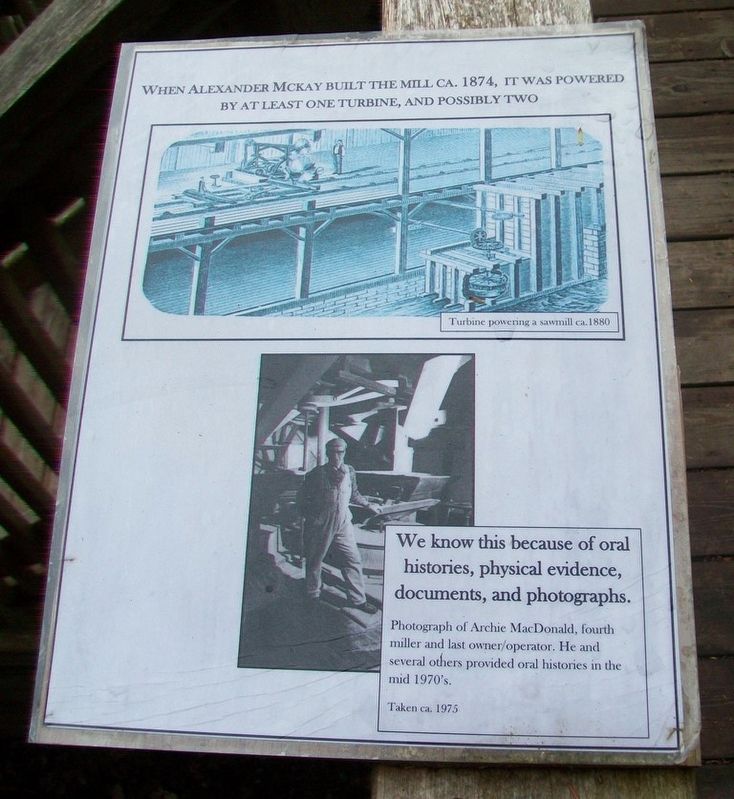
Turbines began to become commonplace in the mid-1800's and had virtually replaced vertical waterwheels by the mid 1860's.
Below are a number of illustrations showing typical mill setups and power transfer.
In 1881 the Schoellkopf Power Station . . . — — Map (db m108183) HM
The land for the church was
donated by
Mr. John R. Hayman
and was contracted to be
built for the sum of one
thousand, four hundred
thirty two dollars.
The closing service for
St. Andrew's Presbyterian
Church was held
December . . . — — Map (db m108184) HM
The First Nations
Native peoples have lived around the Chignecto Isthmus for thousands of years. Travelling in family groups and small nomadic bands, they moved from area to area harvesting seasonal food sources.
Early French explorers were . . . — — Map (db m112112) HM
Pugwash sits on top the largest salt deposit in Atlantic Canada. The train tracks, bridges, and wharves that defined the tapestry of the village infrastructure changed significantly over the decades as local industry evolved, including the . . . — — Map (db m108068) HM
While lobster boats have filled the local wharves for generations, the community's most unique feature may have been the 130 ft. (39.6m) smoke stack belonging to Nova Scotia Clayworks on the opposite side of the harbour. Started in 1889, the . . . — — Map (db m108078) HM
The Pugwash Railway Station, completed in 1892, is one of only two stations designed by Sir Sandford Fleming that is still standing in Nova Scotia. The station is also famous for its part in the 1957 "Thinkers Conference" where Pugwash native . . . — — Map (db m108069) HM
Historically, the main streets were lined with hotels, merchants, and services one would expect of a long-standing port village. The village endured seven devastating fires between 1877 to 1929 that permanently changed the street-scape . . . — — Map (db m108083) HM
The station was built in 1888. Rail service to Pugwash commenced in 1890 and ceased in 1993. Five miles of track linked Pugwash to the Shortline at Pugwash Junction. The Shortline ran from Pictou to Oxford Junction linking it with the rail track . . . — — Map (db m108070) HM
[Great War Honored Dead]
Douglas Langille • Harold Esty Benjamin
Percy Erle Benjamin • William McLean Borden
Cecil Raymond Richards • Frederick Elias King
Frank Demings • Harry Hector McLellan
Andrew Gray McPherson • George Selig . . . — — Map (db m108059) WM
The first settlers of Port Royal must have been aware of the extraordinary fertility of the immense salt marshes that surrounded them The height of the wild grasses alone would have been a clear sign of very productive soil. Until the . . . — — Map (db m141244) HM
The Whitehead Canal is located between Whitehead Harbour and Witch Cove. Prior to its construction, fishermen had to haul their
boats over a narrow beach between Whitehead and Molasses Harbour (now Port Felix) at a spot known as "The Haulover". . . . — — Map (db m139515) HM
This is the starboard propeller of the Canadian coastguard [sic - Coast Guard] Icebreaker, John A. MacDonald [sic - Macdonald]. The propeller was damaged while the John A. MacDonald was assisting the 115,000 ton oil tanker, SS Manhattan, in her . . . — — Map (db m113082) HM
Sullivan’s Pond was a vital feature of the historic Shubenacadie Canal, the traditional water route of Mi’kmaq Indians connecting the harbour at Dartmouth with Minas Pasin and the Bay of Fundy. When the Canal operated, from 1861 to 1870, water . . . — — Map (db m108732) HM
This totem pole, carved by three Kwakiutl Indian carvers from a log of western red cedar, is a gift to the 1969 Canada Games Society on the occasion of the first Canadian Summer Games, held in the twin cities of Halifax and Dartmouth, Nova . . . — — Map (db m108731) HM
An avid walker, trail enthusiast, leader, mentor and diligent worker, Vera B. Stone defines the Trans Canada Trail movement in Nova Scotia. As a founding member and a longstanding Chair for the Trans Canada Trail Committee of the Nova Scotia . . . — — Map (db m113189) HM
Erected
by the
Commissioners
of the
Public Gardens
in commemoration
of the services
of our
Citizen Soldiers
in the
South African
Campaign
1899~1902 — — Map (db m112796) WM
Dedicated to the original Irish
settlers of 1749 and to the
contributions of the Irish
community to Halifax, to
Nova Scotia and to Canada
Tíolactha do na hÉireannaigh a
bhain fúthu í Halifax sa bhliain
1749 is mar aitheantas da . . . — — Map (db m113130) HM
English:
The Halifax City Hall, erected between 1887 and 1890, is the
largest and one of the oldest municipal buildings in Nova Scotia.
Designed by a local architect, Edward Elliot, its elegant facade
features an attractive and . . . — — Map (db m139509) HM
Open for viewing daily, 10:00am to 5:00PM
Come visit the ship, on the waterfront,
behind the Maritime Museum Of The Atlantic
HMCS Sackville is the last of 267 Flower Class Corvettes
built for the Allied Navies during WWII.
Of . . . — — Map (db m112799) HM
National Historic
Civil Engineering Site
Ocean Terminals
1912-1928
A tribute to the civil engineers
and contractors who designed and built these
ocean terminals Canadian Society for
Civil Engineering June 1998
Site historique . . . — — Map (db m139330) HM
Hurricane Juan struck Halifax on September 29, 2003, devastating the Halifax Public Gardens. A volunteer-led foundation was formed to raise funds and restore the Gardens and historic Horticultural Hall.
This fountain and plaza were dedicated on . . . — — Map (db m112821) HM
The Naval Dockyard Clock was fabricated in London, England in 1767 by Ayneth Thwaites. It has kept time in peace and war for generations of sailors and dockyard civilian workers from 1772 to 1993. The Dockyard Clock is the last . . . — — Map (db m113186) HM
Studio Notman Studio, 1897
[Historic photo of the fountain unveiling]
—————————————
Erected by the Garden Commissioners
in commemoration of Queen Victoria's . . . — — Map (db m112947) HM
What would you do with a 30-metre (0.01-mile) outcrop of granite in your backyard? Artist William deGarthe decided to carve a work of art from the granite you see here.
In 1977, at the age of 70, deGarthe picked up his chisels and power tools and . . . — — Map (db m112680) HM
This work of art is a lasting memorial to the gallant men of Peggy's Cove, Nova Scotia, who harvest our oceans. The monument depicts from left to right: Fisherman's Family; Peggy of the Cove; Fishermen at Work.
This monument was donated to the . . . — — Map (db m112691) HM
How do you build a house on exposed granite bedrock where there are few trees to provide lumber, let alone protection from wind, rain and high tides? This is the challenge faced by the first families to settle Peggy's Cove.
Using the trees that . . . — — Map (db m112574) HM
You've probably seen many paintings of Peggy's Cove. Famed marine artist and sculptor William deGarthe may have painted some of these works.[1]
Born in Finland in 1907, deGarthe came to Canada in 1926, eventually settling in Halifax. An art . . . — — Map (db m112693) HM
From the outside it looks like a traditional lighthouse, but looks can be deceiving. Step inside and you'll find yourself in a post office [1], the only one of its kind in Canada and perhaps the world. Every summer since 1975 the Peggy's Cove . . . — — Map (db m112659) HM
Français:
Cette bouée ancrée dans le havre de Chéticamp permettait aux grands transatlantiques de tourner sur eux-mêmes. Elle avait été entièrement attachée avec des rivets chauds. Elle servit de 1928 à 1946.
. . . — — Map (db m139797) HM
English:
Work began on a causeway and canal complex between Cape Breton Island and mainland Nova Scotia in 1953 under a tri-party agreement between the federal Department of Transport, the Nova Scotia Department of Highways and . . . — — Map (db m139301) HM
English:
A canal is a manmade waterway connecting two bodies of water. When one body of water is higher than the other, the canal uses a lock, in this case, a tidal lock consisting of two sets of gates, to compensate for the . . . — — Map (db m139302) HM
English:
The foundation of this massive stone structure rests 66 metres below the Strait of Canso, creating the world’s deepest causeway. More than 9 million tonnes of rock fill were dumped into the strait between 1952 and 1955 . . . — — Map (db m139303) HM
This plaque commemorates
the 235th year of
the Grand Pre Marsh Body
1760-1995
in honour of the dykeland farmers,
past and present, for their 235 years
of dedication and sacrifice, and their
continuing struggle to protect and
maintain these . . . — — Map (db m138789) HM
In 1759, the British authorities subdivided Nova Scotia into counties. The County of
Kings was divided into three townships: Cornwallis; Falmouth and Horton.
The Horton Town Plot (or plan), sited on the hills above Horton Landing and . . . — — Map (db m139033) HM
Bridging the LaHave
It is only fitting that a place named "Bridgewater" should have such a rich history of bridges. Between 1825 and 1983, five bridges have spanned the LaHave River, connecting east and west Bridgewater. Prior to . . . — — Map (db m112428) HM
Up in Flames
In the cold, early hours of January 12, 1899, a fire began in the basement store of E. B. Simonson, located in the Music Hall at the corner of Dominion Street, and Commercial (now King) Street, where you are . . . — — Map (db m112426) HM
Prominently sited on the parade square, this church was an important symbol of British authority and Anglican dominance for Lunenburg's early settlers, who were mainly German-speaking Protestants. From construction in 1754 through many alterations . . . — — Map (db m112453) HM
The first Anglican services in Lunenburg were held outdoors on this site and were conducted by a missionary from England. A two-storey structure in the New England Meeting House style was built between 1754 and 1763. The oak frames were . . . — — Map (db m112486) HM
Beginning in the early hours of November 1, 2001, fire ravaged this historic church, substantially destroying the building. Undaunted by the destruction, the parishioners decided to restore the church. With financial help from friends around the . . . — — Map (db m112454) HM
This bell hung in the tower of St. John's since 1814 and served as the tolling bell for over 185 years. It was cast at the Whitechapel Foundry in London, England. On November 1, 2001, fire ravished through the Church, destroying the tower and . . . — — Map (db m112432) HM
Lunenburg is home to the oldest worshiping Lutheran congregation in Canada. The first Lutherans, mostly Germans from farming districts of the Upper Rhine, settled in the Town in 1753. Initially they worshiped outdoors and later were allowed to . . . — — Map (db m112480) HM
In memory of the crew of the
Beam Trawler Jutland
foundered at sea March 11, 1920
These crossed anchors recovered from
fishing banks on Jutland's previous trip
are placed as a symbol of our hope that
their souls are resting in . . . — — Map (db m112407) HM
Designed by Halifax architect Herbert E. Gates, this dignitied town hall was constructed in 1901-1902. Such buildings were central to civic life across the country, providing accommodation for the growing number of services administered by local . . . — — Map (db m112404) HM
The tradition of marking a burial grew out of people's inability to accept the finality of death. Since stone, by the human timescale, is not subject to decay, it represented something eternal.
The old burying grounds is one of Nova Scotia's . . . — — Map (db m112406) HM
Fishing has been the backbone of Yarmouth's culture and economy for over 200 years. In the early days, salted dried cod was shipped by schooners and barques headed to the West Indies in exchange for rum, molasses and sugar. Today Yarmouth's . . . — — Map (db m107349) HM
The Southwestern shore of Nova Scotia, including Yarmouth County, is home to one of Canada's largest fisheries. For over two hundred years, fishing boats have sailed past this point, as well as from other ports in this region, to fish groundfish, . . . — — Map (db m107638) HM
An enduring symbol of Yarmouth's historic and economic ties to the sea, a lighthouse has towered over the rocky headlands of Cape Forchu since 1839, guiding mariners to the safety of Yarmouth Harbour. The current lighthouse was automated in . . . — — Map (db m107293) HM
The Town of Yarmouth, and its surrounding area, was settled in 1761 by Planters from Massachusetts. These settlers fished along the coast and harvested lumber from the forests to build homes, businesses and sailing vessels. By the . . . — — Map (db m107298) HM
Balise canadienne
Lorsque Samuel de Champlain visita la région en 1604, il la nomma Cap-Fourchu. Un an plus tard, Champlain s'installa à Port-Royal ou, La Cadie, un nom dérivé du nom « L'Arcadie » qu'un explorateur italien aviat donné à la . . . — — Map (db m107359) HM
Pieces of the Past
Since 1840, a lighthouse has kept watch over Cape Forchu and the approaches of Yarmouth Harbour.
In 1962, the original lighthouse was replaced with the iconic "apple core" structure that towers over the Cape today.
The . . . — — Map (db m107551) HM
A Yarmouth - Viking Connection?
This scenic trail is named after the famous Norse explorer, and son of Eric the Red, Leif Ericson, who may have visited these shores sometime around 1000 AD.
Many scholars regard Leif Ericson as the first . . . — — Map (db m107487) HM
Jusaqu'aux années 1950 on pouvait encore voir plus de 1000 barges ou meules de foin entre la Pointe-du-Sault et la Pointe-des-Hubbard, surtout dans la région appelée « Passe de pré ». Des hommes habiles à la faux pouvaient faucher environ . . . — — Map (db m108766) HM
Le Village presents the lifestyle, culture and traditions of the Acadians of Nova Scotia at the turn of the 20th century, approximately 250 years after they first settled in the Pubnico area. This is the longest established Acadian region . . . — — Map (db m108266) HM
Les pionniers acadiens
Pubnico est le plus ancien village acadien encore habité par les descendants des familles fondatrices. Vous trouverez, dans l'annuaire téléphonique, près de 400 personnes du nom d'Entremont. Ils sont les descendants . . . — — Map (db m107971) HM
Récolter la mer
Vous êtes debout sur l'un des quais de pêche les plus achalandés au Canada.
Autrefois, le hareng était pêché dans des parcs en fascines, ou « nijagans » inventés par les Mi'kmaq. Le poisson entrait dans le parc . . . — — Map (db m108006) HM
Le plus ancient tribunal
Le premier gouvernement local de la région du comté actuel de Yarmouth fut institué en 1789 par l’établissement du Tribunal des Sessions générales de la paix qui servait les districts de Yarmouth et d’Argyle. Il . . . — — Map (db m112162) HM
Next to the Court House on the east side of the street was the Tusket Cycle Company and just south of that, the Methodist Church built in 1877. On the opposite side of the street, the building in the foreground with the bundle of . . . — — Map (db m108772) HM
This Ballard [sic - Bollard]
was located on a
wharf in Yarmouth
in the early 1900's.
It's purpose was to
tie ships to the wharf.
It weighs 450 pounds.
Donated by
Mr. Danny MacIsaac — — Map (db m172552) HM
This replica was created and donated
to the citizens of Yarmouth, Nova Scotia
from
Doug Koohtow, Holland Landing, Ontario
May 28, 2014 — — Map (db m107869) HM
This park
named in honor of
Charles Sydney Frost, M.C.
Native son who,
through diligence
and ability, became
President of the
Bank of Nova Scotia
June 14, 1956 — — Map (db m107872) HM
[Excerpt from Town of Yarmouth informational sign]
Get your bearings
Named after Charles Sydney Frost, a Yarmouth resident who became president of the Bank of Nova Scoita, this green space at the heart of the town is the perfect place to . . . — — Map (db m107960) HM
This Anchor was donated to Freinds [sic - Friends] of the Yarmouth Light Society, by Bay Ferries. The fluke was broken off, when it got caught in [the] rocks on bottom, while at anchor just off the lighthouse. This anchor came off the M.V. . . . — — Map (db m172550) HM
Early manufacturing in Yarmouth grew in support of the shipbuilding industry, the fishery, and the maintenance of vessels engaged in shipping. The flourishing textile industry had its origins in the ability to import inexpensive raw materials, . . . — — Map (db m107320) HM
Erected in 1911 at a cost of $1,200.00, the original Milton Clock was donated by Mrs. Robert Caie. The mechanical works of the clock were manufactured by J. Smith and Sons, Midland Clock Works, Derby, England. Located in the tower at the . . . — — Map (db m106141) HM
The first vessel known to have been built in Yarmouth was launched by John Sollows at Fish Point in 1764. Over the years, many ships were built in nearby communities such as Argyle, Tusket, Plymouth, Salmon River, Meteghan, and Belliveau's . . . — — Map (db m106216) HM
From its early beginnings on Cape Breton Island the shipbuilding industry grew as settlement did in the late 18th century. During the Golden Age of Sail in the 19th century, thousands of wooden vessels of all sizes were built in bays and harbours . . . — — Map (db m106067) HM
The Killam Family Built a Business
By the third quarter of the nineteenth century, many Yarmouth companies and their owners were enjoying substantial profits as a result of their investments in shipping and labours as commission . . . — — Map (db m112200) HM
Merchants and Mariners
True to the code of merchant-mariners, Parker-Eakins & Co. saw their mission as an endeavor “to facilitate the production, distribution and exchange of goods and services for mutual profit and . . . — — Map (db m112171) HM