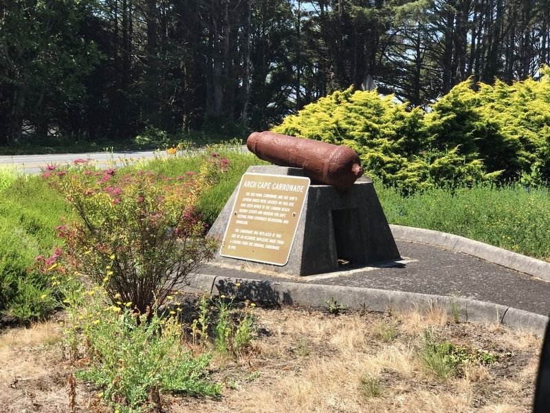
The 1821 naval carronade and the ship's capstan which were located on this site have been moved to the Cannon Beach History Center and Museum for safe keeping from continued weathering and vandalism.
The carronade was replaced at this site by an . . . — — Map (db m177297) HM
The Columbia River is a highway for huge amounts of freight. The most frequent outbound cargoes include wheat and other agricultural products from the inland Northwest, logs and lumber, and mining products like coke or potash. Entering the river, . . . — — Map (db m113238) HM
Before the fire of 1922, much of downtown Astoria was built on pilings over the river. People built out from the original hilly shoreline, creating a level commercial district with access to the water.
Every type of business might be . . . — — Map (db m113237) HM
This Mansion
was erected in 1883 by
Captain George Flavel,
Pioneer Columbia River Bar Pilot
and business leader
The family home for fifty years,
this property was presented to Clatsop County
by his great granddaughter,
. . . — — Map (db m113016) HM
This authentic reconstruction of the 1852 U.S. Custom House was built to commemorate the bicentennial of the U.S. Custom Service. Work began in October, 1992 and was completed in May, 1994.
Reconstruction methods and tools duplicated those of . . . — — Map (db m113821) HM
On Christmas Eve, 1885, direct current flowed from a small dynamo in a planer shed of West Shore Lumber Mills to light Astoria's first electric lamps. Wires strung across housetops connected the dynamo to 30 arc lamps. Customers paid $16 a lamp per . . . — — Map (db m113568) HM
The poles or "piling" are logs from 80-year old Douglas-fir trees. They are a maximum of 60 feet in length and are embedded up to 20 feet into the river bottom. The rows of piling were used during the log sorting and raft making process. . . . — — Map (db m114698) HM
In October 1856, the U.S. Lighthouse Board entered this fog bell and Cape Disappointment Lighthouse into service, thus establishing the first light station on the Oregon and Washington coast.
Positioned on the north side of the entrance to . . . — — Map (db m113153) HM
Patterson Bridge
(Rogue River Bridge)
Completed January 21, 1932 and dedicated In Memory to the Governor of Oregon Isaac Lee Patterson (1926-died in office 1929)
1932.... The bridge was considered the most advanced concrete . . . — — Map (db m113391) HM
The dam and powerhouse were built in 1910 and 1913 respectfully by the privately-owned Bend Water, Light and Power Company. and were subsequently sold to the Pacific Power and Light Company. The dam, which holds back the waters of the Deschutes . . . — — Map (db m157894) HM
From the woods to the Deschutes River, the log was hoisted by the bull chain into the mill from the river to the log deck.
It was then directed to the band saw in one of the three head rigs, where the process began.
It was the head sawyer's . . . — — Map (db m113919) HM
A Big Piece of Reedsport History
Here, restored by citizens of Reedsport, is one of the largest steam donkeys to work the Oregon woods, the Smith and Watson 12 X 13 compound geared universal yarder. It was placed in service in 1915 . . . — — Map (db m113331) HM
Originally the first lighthouse in the Oregon Territory. Was built in 1857 near the mouth of the river.
It was undermined and destroyed by flood in Feb. 1864.
Rebuilt here in 1891 and completed in 1894.
It shines a guiding light to all . . . — — Map (db m113915) HM
The original Hebe Fountain was a joint project of the 1895 Mental Culture Club (now known as the Roseburg Woman's Club) and the Women's Christian Temperance Union. Providing water for horses, dogs, and humans, the fountain stood in the intersection . . . — — Map (db m112848) HM
Has Been Designated a
National Historic Landmark
This property possesses national significance
in commemorating the history of the
United States of America
Kam Wah Chung Company Building is the best and earliest known . . . — — Map (db m112884) HM
Although steel has been made for centuries, it wasn’t until the Bessemer process was introduced in the 1870s that it could be produced in quantity.
The Bridge of the Gods mural is the creation of Larry Kangas, of Beaverton, . . . — — Map (db m112267) HM
At the turn of the century, the Beekman Bank Well was a refreshing stop for two seasonal creeks, Jacksonville suffered from an inadequate domestic water supply for 60 years following the 1852 gold rush. This old well is one of several wells dug in . . . — — Map (db m113397) HM
With the faith and courage of
their forefathers who made
possible the freedom of these
United States
The Boy Scouts of America
dedicate this copy of the
Statue of Liberty as a pledge
of everlasting fidelity and
loyalty . . . — — Map (db m112539) HM
December 22, 1964 dawned on the Rogue River with heavy rain and unseasonably warm temperatures. As the day passed, townsfolk cast nervous glances at the rising turbid river water. They began moving their belongings to upper floors and vacated their . . . — — Map (db m112765) HM
The City of Klamath Falls in cooperation with the U.S. Fish and Wildlife Service, Oregon Watershed Enhancement Board, and Oregon Wild re-established a lake fringe wetland at Marina 1 in Moore Park in 2012. The purpose of the project is to lessen . . . — — Map (db m112876) HM
Can you feel the sea wind?
The lighthouse can, too!
For a lighthouse, standing out in the sea spray and storm winds is part of the job description.
For more than a century of working life, Heceta Head Lighthouse has taken a . . . — — Map (db m113303) HM
From top to bottom, Heceta Head Lighthouse
is built to guide from afar.
The light’s height was most likely chosen to maximize its range while minimizing the chances it would be hidden by fog.
Unlike most Fresnel lenses of the day, . . . — — Map (db m113304) HM
Would you make it as a
Heceta Head Lighthouse keeper?
Imagine living here, part of a tiny, isolated community whose lives revolved around the beacon of Heceta Head Light. You would:
Work day and night to keep the light in good . . . — — Map (db m113305) HM
Lighthouses are not just scenic structures – they are life-saving innovations.
In the 19th century, most traffic sailed by offshore. To steer true, and to avoid hazards such as reefs and shoals, ship captains needed land-based . . . — — Map (db m113916) HM
Constructing Over the Siuslaw
The Siuslaw River Bridge incorporates Art Deco, Moderne, Gothic, and Egyptian influence that were important to McCullough. Due to its ability to open at the center, the Siuslaw River Bridge best represents . . . — — Map (db m113537) HM
If this historic bridge and tunnel weren’t here, what would it be like to cross Cape Creek?
Engineers building the Pacific Coast Highway in the early 1930s encountered an unusual challenge here at Cape Creek, a deep, offset gorge, . . . — — Map (db m113301) HM
(panel 1) The Goodpasture Bridge is a reminder of an earlier era, when covered bridges were common sights for motorists on Oregon’s back roads. But this bridge is more than just a quaint remnant — it’s still an . . . — — Map (db m113714) HM
Even though Newport was only four miles (7 km) away, bad weather, poor roads, and the demands of their work combined to tie the keepers and their families to the Yaquina Head Light Station.
What did they do?
They caught, shot . . . — — Map (db m112415) HM
By modern standards, the regular routine of a lighthouse keeper was monotonous. It was, however, sometimes interrupted by unexpected moments of drama.
"Last night lightning struck the office and storeroom building.
It tore off the . . . — — Map (db m112414) HM
Yaquina Head's light is 81’2" (25 m) above the ground and 162' (49 m) above mean sea level; the top of the tower is 10' (3 m) higher still.
Higher is better
On America's rugged west coast, keeping lights low enough to be . . . — — Map (db m112413) HM
For more than 140 years, Yaquina Head Lighthouse has graced this headland. While the lighthouse structure has endured, the technology of the lighthouse lamp has evolved and directly influenced the community.
1873-1930s
• Funck's Hydraulic . . . — — Map (db m177191) HM
The old Yaquina Bay Lighthouse established in 1871 is the earliest aid to navigation, standing within the range of the first recorded landfall made from a ship to the shores of the Pacific Northwest. Captain James Cook made this landfall on March . . . — — Map (db m113917) HM
Long before today's modern paved highways, rough, muddy wagon roads provided the only inland access to Oregon's coast, and travel north or south was often on the beach at a low tide.
Construction of a continuous coastal road, dubbed the . . . — — Map (db m113501) HM
These Corinthian column segments originally were part of those that graced the west and east entrance porticos of Oregon's first state house. The cornerstone for the original Capitol was laid October 8, 1873. The building was partially . . . — — Map (db m113717) HM
Using the sun’s energy, the chlorophyll in a plant’s leaves produce sugars and starches that nourish the plant.
Shafts of light dance briefly through this deep canyon, illuminating shade-tolerant ferns, mosses, and lichens . . . — — Map (db m112252) HM
The US Department of Agriculture describes cedar as possessing a natural resistance to rot…
It is well recognized for its longevity and strength above other wood products.
Oneonta Bluff presented an obstacle to engineer Samuel C. . . . — — Map (db m112251) HM
The glistening tide of salmon returning annually to spawn in the Columbia River and its tributaries was of legendary proportions. For thousands of years, American Indians used spears and dip nets to harvest this seasonal bounty. But fishwheels . . . — — Map (db m158545) HM
Classic symbol of the Columbia River Gorge, Vista House beckons travelers to Crown Point to revel in an extravaganza of water, cliff, and sky. Samuel C. Lancaster, design engineer of the Historic Columbia River Highway, envisioned this outcropping . . . — — Map (db m86662) HM
Beginning here, the Willamette Meridian was established running north to Puget Sound and south to the California border, and the Base Line was established running east to the Idaho border and west to the Pacific Ocean.
From the surveyed lines, . . . — — Map (db m113946) HM
Ritner Creek Bridge, one of the covered bridges remaining in Oregon west of the Cascades, almost became a memory in 1974.
Declared structurally unsafe, it was scheduled for removal.
The children of Pedee School along with the citizens in the . . . — — Map (db m113502) HM
During the early development of our national parks (1920s) an evolution in design ethics was taking shape. This design ethic emphasized and organic approach to architecture and landscape - designing in harmony with nature. Nature was the most . . . — — Map (db m113774) HM
Three-quarters of a mile of roadwork added safety and beauty to the Coast Highway flanking Neahkahnie Mountain. Talented masons who had once worked for the Works Progress Administration blasted away tons of rock off the mountainside and built . . . — — Map (db m113735) HM
The French hand-ground Fresnel lens at Cape Meares is one of only two eight-sided lights in the United States – the other is in Hawaii. Keepers were given detailed instructions for maintaining the masterpiece.
A brilliant . . . — — Map (db m113918) HM
Today, engineers use high resolution satellite photography and advanced computer modeling software to design roads.
Gazing down upon the graceful, winding Historic Columbia River Highway, it is easy to forget how challenging its . . . — — Map (db m112250) HM
"...at three in the evening we arrived at the entrance to Quinnette creek (known today as Mill Creek) which we ascended a short distance and encamped at the place we have called rock fort camp." - Meriwether Lewis, April 13, 1806 . . . — — Map (db m158415) HM