A Route and a Power Source: The Elkhorn Valley The Elkhorn Valley was a natural travel corridor into north-central and western Nebraska. Water, wood, and grass provided people and animals the critical resources to move overland wagons. Travel . . . — — Map (db m159076) HM
Through this valley passed the Oregon Trail, highway for early explorers, fur traders, California-bound gold seekers, freighters, and brave pioneers seeking new homes in the West. Traffic was especially heavy from 1843 to 1866. At times as many as . . . — — Map (db m45521) HM
The Lincoln Highway Association was founded in 1913 to promote a transcontinental automobile route from new York City to San Francisco. Dedicated on October 31, 1913, the route was marked by the letter “L” within red, white, and blue . . . — — Map (db m45520) HM
The trail which followed the south side of the Platte River was the main route to Oregon and California. Fur traders going to the Rocky Mountains took the first wagons over the trail in 1830. Oregon-bound missionaries followed in the mid-1830s, and . . . — — Map (db m53268) HM
In April 1860 Joseph E. Johnson, a Mormon, established a road ranche at Wood River Center, today’s Shelton, and began publishing The Huntsman’s Echo, the first newspaper in Nebraska west of Omaha. He had earlier edited papers in Council Bluffs, . . . — — Map (db m45423) HM
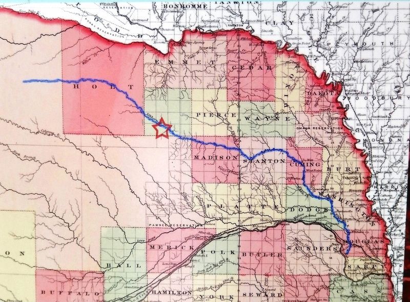
You are within sight and sound of a Midwestern dream come true - the Meridian Highway.
In 1911 a group of Kansans and Nebraskans drafted a plan for a highway paralleling the sixth principal meridian through America's heartland from Canada . . . — — Map (db m101393) HM
In 1867 an Army tent camp was established near here to provide protection for Union Pacific Railroad construction crews. Three years later it became Fort Sidney, the nucleus for the town of Sidney, county seat of Cheyenne County. The rush to the . . . — — Map (db m231061) HM
Gold was discovered in the Black Hills in August, 1874. By the spring of 1876, the Army had stopped enforcing a treaty which reserved the hills for the Sioux Indians. Miners soon began to pour into the gold regions. From 1875 to 1881, the . . . — — Map (db m231079) HM
Transported on a 107 foot tractor-trailer
to present location on Sept. 12. 1996 from
the Army National Guard base at Mead, NE.
Dedicated Nov. 11. 1996
In memory of all who served — — Map (db m161559) HM WM
The first Etna post office (1885-1895) was located three miles to the northwest. A new post office operated 1.5 miles east until 1921. In 1907 Etna saw the opening of a school, store, and telephone exchange. The store was enlarged by Andrew . . . — — Map (db m181798) HM
Following the 1874 establishment of military posts near the Red Cloud and Spotted Tail agencies for the Oglala and Brule Sioux, the army laid out a forty-two-mile road to transport military and Indian supplies between the agencies and posts.
Oglala . . . — — Map (db m89346) HM
From about 1837 until 1850, more than a quarter million buffalo robes bought from Indians and 27 tons of fur company trade goods were hauled over the 300 mile long Fort Pierre-Fort Laramie Trail that followed the White River through this area. First . . . — — Map (db m4530) HM
Sidney — Black Hills Trail 1875-1881 Freight wagons, stagecoaches and horsemen carried supplies, passengers mail and gold between Sydney Nebraska and the gold-mining towns in the Black Hills of South Dakota. Fort Pierre — Fort Laramie . . . — — Map (db m235932) HM
An important thoroughfare between Sidney, Nebraska and the Black Hills during the years 1876-1880. Heavily traveled by stage coaches, freight wagons and prospectors going between the railroad at Sidney, and the gold fields. — — Map (db m158997) HM
Here in Dawson county, much of the early history is concerned with the pioneer trails to the west. The Mormon Trail to Utah and the first transcontinental railroad passed through here on the north side of the Platte River; the Oregon Trail and the . . . — — Map (db m68060) HM
This old station once stood on the upper 96 Ranch west of here and south of the Platte River, on the original Pony Express route. It was moved and restored by Gothenburg Post No. 64, American Legion. Erected by the Gothenburg Chamber of . . . — — Map (db m86775) HM
From the late 1840s through the 1860s, an exodus of more than 70,000 Mormons passed by here on their way to their “New Zion” in Utah. Starting from Nauvoo, Illinois in February 1846, the first group of at least 13,000 Mormons crossed into Iowa to . . . — — Map (db m86778) HM
The southeast corner of the Nebraska panhandle was organized November 6, 1888 from a part of Cheyenne County. Deuel County has two incorporated towns, Chappell, the County Seat and Big Springs.
Before 1850 Teton Sioux Indians camped on the . . . — — Map (db m119438) HM
Pioneers traveling west on the Oregon Trail discovered this spring that Plains Indians had frequented for centuries. It provided an oasis for man and beast alike in the “Great American Desert.’
In 1867, Union Pacific railroad workers named it . . . — — Map (db m51461) HM
Since 1841, Nebraska's Platte River Valley has been the historic highway of westward migration. In this area, the Overland Trail divided into two branches, one which followed the north and the other the south forks of the river. Emigrants . . . — — Map (db m68070) HM
Here is the valley of Lodgepole Creek through which passed historic trails, telegraph lines, and railroads. The famed Pony Express followed the valley in 1860-61. "Nine Mile" Pony Express station was located just southeast of present Chappell; "Pole . . . — — Map (db m223445) HM
This marker has text on both sides
Dedicated October 4, 2003
Hughes’ Ranch
Added Station
July 1, 1861 - Nov. 20. 1861
by
Deuel County
Historical Society
James Stretesky
Sterling Monument Company
Pony . . . — — Map (db m79441) HM
The Mormon Pioneer Trail from Nauvoo, Illinois to the Rocky Mountains passed here April 17, 1847. In this vicinity a military-type organization was formed with Brigham Young, Lieutenant General; Stephen Markham, Colonel; John Pack and Shadrach . . . — — Map (db m58566) HM
Fleeing heated religious and political hostility and persecution, many members of The Church of Jesus Christ of Latter-day Saints (widely known as Mormons) abruptly fled their homes in Nauvoo, Illinois in February 1846. Unprepared for the cold of . . . — — Map (db m90577) HM
Dundee, Omaha's first suburb, was connected to downtown by the streetcar. Dundee was literally the end-of-the-line. The streetcars reversed their course just west of this site. In 1891, a steam driven "trolley" and then a horse-drawn car brought . . . — — Map (db m58356) HM
Since times unrecorded, springs from the Ogallala Formation relieved travelers through the Republican Valley. In 1930 Benkelman citizens improved a nearby spring to benefit motorists on NE 3 (later US 34). The 1935 Republican River flood destroyed . . . — — Map (db m180993) HM
After the slaughter of the buffalo and the last of the Indian hunts, ranchers moved into this part of the Republican River country in 1875. Among them were I.P and Ira Olive, who were using this canyon on their range in 1876. Herds of Texas cattle . . . — — Map (db m79219) HM
Look around you. The impact of the Homestead Act is clearly visible. Grain elevators, fertilizer plants, housing developments, state highways, modern farms – these and other features are tangible evidence of the Homestead Act’s success in . . . — — Map (db m47518) HM
Railroads played a key role in the development of the Heritage Highway corridor. Trains brought settlers and goods west to the new towns and took farm products back to market. As times have changed and transportation has evolved, many railroad . . . — — Map (db m47620) HM
Many Heritage Highway communities began as river settlements. Beatrice was founded in 1857 near the bend of the Big Blue River. The first building, known as Pap Towle's cabin, was constructed just north of the present Gage County Historical Society . . . — — Map (db m47627) HM
You are standing on an old road trace, lined with cottonwood trees, where freight was hauled by wagon. The ability to get goods to market is yet another reason Daniel Freeman homesteaded here, four miles from the town of Beatrice.
Freight roads . . . — — Map (db m47584) HM
Byway 136 was designated the Heritage Highway in part because of the many historic trails that are now part of it. You are standing on the historic De Roin Trail. The De Roin Trail began at the Missouri River port town of Brownville on the eastern . . . — — Map (db m47623) HM
Originally dedicated 1934
Rededicated 2000
Symbolism of the Mural
Just as our own Nebraska natives left their homes to fight wars on foreign soil, the use of Endicott brick represents native earth that brings all of us back to our . . . — — Map (db m48234) HM
From October 1862 until March 1863 stagecoaches of the Central Overland California and Pikes Peak Express passed near here along the Oketo Cutoff. The cutoff diverged from the Ft. Leavenworth to Ft. Kearny Military Road northeast of Marysville, . . . — — Map (db m238213) HM
Here, covered-wagon travelers faced the most difficult terrain since their departure from Missouri. One man said: “I cannot say at what angle we descend, but it is so great that some go so far as to say ‘the road hangs a little past the . . . — — Map (db m87335) HM
The Way West -- The Oregon Trail
For the wagon-traveler, the road from Independence, Missouri, to the Far West was “2,000 miles, one step at a time.” Wagon Brakes The most common wagon brake was the rough-lock. It slowed the . . . — — Map (db m87757) HM
Travelers reached this point over the trail you see stretching out across the prairie to the southeast. They left the last real settlement at Westport Landing or at Independence, some 600 miles from here. Most of them took about 40 days to . . . — — Map (db m87332) HM
This ravine started as a set of wagon ruts cut through the grass and soil by heavy iron-shod wheels. It is but one example of the long interaction between man and the environment in this region. This walk to the top of the hill has . . . — — Map (db m87337) HM
Under a picture of a large covered wagon: The Conestoga was a heavy freight wagon. Very few passed over the Oregon Trail because of the rough terrain. Under a picture of a travelers in a Prairie Schooner: Thousands of . . . — — Map (db m87760) HM
Fleeing heated religious and political hostility and persecution, many members of The Church of Jesus Christ of Latter-day Saints (widely known as Mormons) abruptly fled their homes in Nauvoo, Illinois in February 1846. Unprepared for the cold of . . . — — Map (db m3705) HM
It has been estimated that at least 20,000 persons died on the overland trail, between 1842 and 1859. This averages ten graves per mile over the 2,000 mile trail. Of the hundreds who died while crossing Nebraska, only seven identifiable graves . . . — — Map (db m231177) HM
This horse drawn tank wagon was used by Sinclair Oil beginning in 1917. The tank had an amazing 300 gallons of fuel or gasoline that was delivered to farmers and homesteads for numerous uses. In comparison, today's transport trucks hold 7,000 to . . . — — Map (db m53267) HM
The Lincoln Highway association, formed in 1913 to build a New York to San Francisco highway, sold “highway memberships” to raise funds for the project. In Nebraska the road, which traversed twelve states, extended westward from Iowa . . . — — Map (db m45203) HM
From 1847 to the 1860s, the Mormon migration along the Great Platte River Road marked a distinctive chapter in the history of westward expansion. In contrast to the random migrations of individual families or companies that characterized much of . . . — — Map (db m79695) HM
Here is a section of an original Seedling Mile on the Lincoln Highway. It was completed November 3, 1915. Grand Island was the second city in the United States to build such an example of concrete roadway. The original Seedling Mile extended from . . . — — Map (db m53234) HM
In the spring of 1859, William H. Russell and John S. Jones established The Leavenworth and Pike’s Peak Express to carry passengers and freight from the Missouri River to the Colorado gold fields. The route crossed northern Kansas, detouring . . . — — Map (db m79359) HM
Originally the entire responsibility for highways in Nebraska rested with the counties. In 1917 the Legislature accepted the provisions of a federal law and appropriated money to match federal funds for highway construction. This act marked the . . . — — Map (db m182016) HM
These were the four Pony Express Stations in Jefferson County. Big Sandy Station • Whiskey Run • Rock Creek Station • Otoe StationRock Creek Station was the site where Wild Bill Hickok shot and killed David McCanles, July 12, 1861. Russell, Majors . . . — — Map (db m177362) HM
Pony Express riders and Oregon Trail emigrants used Virginia Station, once located near this site. Indians traded for whiskey at the station and harassed the emigrant trains. The whiskey was dumped in a near-by creek, thus dubbing the station . . . — — Map (db m177351) HM
Tecumseh, the county seat of Johnson County, was incorporated in 1856. It was first called Frances in honor of the wife of Colonel Richard M. Johnson, for whom the county is named. In 1857 the town was renamed for the famous Shawnee Indian chief, . . . — — Map (db m48209) HM
The large hill to the north, which became known as “California Hill,” was climbed by thousands of covered wagon emigrants heading west between 1841 and 1860. Many were bound for Oregon. California became the destination of the majority . . . — — Map (db m51229) HM
Many emigrants to Oregon or California had to ford the South Platte River to continue their trek up the North Platte River to South Pass. The most important ford, known as the Old California Crossing, was a few miles west of present-day Ogallala. . . . — — Map (db m50790) HM
For the 215 miles from the Nebraska-Colorado Line to Grand Island. Interstate 80 parallels the Platte River. This broad flat valley is underlain by deposits of sand and gravel washing in from the Rock Mountains. These deposits contain large . . . — — Map (db m51255) HM
Named for the Oglala band of Dakota Sioux and located on the Union Pacific Railroad, Ogallala was a lusty cowtown of the Old West. From 1875 to 1886 it was a wild and woolly cowboy capital where gold flowed across the gaming tables, liquor across . . . — — Map (db m51222) HM
An etching of Ogallala appeared in an 1878 issue of American Agriculturalist magazine, depicting the town as the terminus of Texas cattle drives. It shows cattle being driven up the trail, across the South Platte River, and into Union Pacific cattle . . . — — Map (db m50784) HM
U.S. Highway 26 and Nebraska Highway 92 were designated as Nebraska’s first scenic and historic byway in 1998. The byway begins in Ogallala and goes north and west past Lake McConaughy to Scottsbluff-Gering and the Wyoming border.
Through the . . . — — Map (db m50802) HM
Mayors from ten towns, along with Governor Norbert Tiemann and the Ogallala High School band, participated in a ribbon-cutting ceremony in Ogallala in December 11, 1968, to open the Sutherland to Big Springs segment of Interstate 80. The completion . . . — — Map (db m50800) HM
This region holds much that is significant to the history of the West. At this point, I-80 follows the route of the Overland Trail, along the South Platte River. Leaving the South Platte near here, the trail continued up the North Platte Valley, . . . — — Map (db m61966) HM
One of the earliest cowboys of the many who rode the long trail north from Texas to Ogallala behind a herd of longhorns. Sanders first arrived here about 1869. He rode for William Paxton during the turbulent open range period of Western Nebraska. He . . . — — Map (db m51225) HM
This friendly hometown mechanic embodies the spirit of the Lincoln Highway in Keith County. He commemorates a simpler, gentler time, when the attendant would pump your gas, check your oil, and wave you on your way with a smile.
Built in 1922, . . . — — Map (db m70370) HM
For generations Nebraska’s Platte Valley provided a natural east-west travel route for native peoples, fur traders, explorers, emigrants, and the military. The first known passage by white men along the Great Platte River Road in the Keith County . . . — — Map (db m50782) HM
When gold was discovered in 1848, California became the main destination. After 1849 many emigrants and gold seekers began traveling the trail on the north side of the Platte. Throughout the peak migration years, the trail to Oregon or California . . . — — Map (db m50783) HM
The Lincoln Highway was proclaimed the nation’s first coast-to-coast highway in 1913. It connected New York City with San Francisco, crossing twelve states and spanning 2,300 miles. The Lincoln Highway was created by an association of automobile . . . — — Map (db m50799) HM
Mormons traveled the Great Platte River Road to fulfill a religious mission. In the 1840s members of the Church of Jesus Christ of Latter Day Saints.(Mormons) moved westward to escape religious persecution. Beginning in 1847 they crossed the Plains . . . — — Map (db m50787) HM
The Pony Express operated for only eighteen months, from April 1860 until October, 1861, delivering mail between St. Joseph, Missouri and Sacramento, California. It ceased operating when the transcontinental telegraph line was completed. During its . . . — — Map (db m50785) HM
Thousands of oxen-drawn wagons passed here from 1860 to 1867, before completion of the Union Pacific Railroad across Nebraska. Carrying military and mining supplies, and emigrants moving west, they cut deep ruts across the tallgrass prairie and at . . . — — Map (db m223457) HM
With the discovery of gold in the Rocky Mountains in the late 1850's , overland freighting and travel intensified. Every few miles westward along the trails, enterprising individuals established road ranches which offered lodgings and provision to . . . — — Map (db m174996) HM
The Barn, built in 1887, is 148 feet long, 70 wide, 40 feet high. It required seven railroad cars of lumber for construction. The original rafter ends under the eaves were shaped as gun stocks. Annie Oakley's trademark, the Ace of Hearts with a . . . — — Map (db m125057) HM
Mormon pioneers enroute from winter quarters, (Omaha) to the valley of the Great Salt Lake, under the leadership of Brigham Young, camped near here May 11, 1847. While in this vicinity William Clayton made a distance-measuring device which when . . . — — Map (db m180898) HM
These reproduction yokes would sit over the necks of two oxen each. Oxbows, small bent wood rods were placed under the oxen's necks and through the holes in the yokes and secured with pins. This allowed the yoke to secure itself against the oxen's . . . — — Map (db m191894) HM
(side 1) Dedicated June 15, 2002
Cold Springs added station
Jul. 1, 1861 – Nov. 20, 1861
Located 1600’ south by Lincoln County
James Stretesky Nebraskaland Days, Inc.
Nebraskaland National Bank
North Platte/Lincoln . . . — — Map (db m125063) HM
This log blacksmith shop and its sister station building, which was a two-story log house, were originally located on the Upper 96 Ranch four miles east of Fort McPherson near the Sam Machette Canyon. In 1931, the log house was dismantled and taken . . . — — Map (db m191700) HM
Sioux Lookout, the highest point in Lincoln County, was a prominent landmark on the overland trails.
From its lofty summit the development of the West unfolded before the eyes of the Sioux and other Indians.
Trappers and traders came by here . . . — — Map (db m107393) HM
Beneath this platform, evidence of the great westward migration still remains. These shallow depressions were once deep ruts created by thousands of hooves, shoes and wheels. The Overland Trail is often visualized as a single well-defined . . . — — Map (db m88677) HM
This is the Platte River Valley, America’s great road west. It provided a natural pathway for westward expansion across the continent during the nineteenth century. Here passed the Oregon Trail, following the South Platte River along much the same . . . — — Map (db m227919) HM
This is the Platte River Valley, America's great road west. It provided a natural pathway for westward expansion across the continent during the nineteenth century. Here passed the Oregon Trail, following the South Platte River along much the same . . . — — Map (db m227920) HM
Lone Tree, a giant, solitary cottonwood, was a noted Platte River landmark as early as 1833. Standing on the north side of the river some three miles southwest of present Central City, the tree was visible at great distance. Several travelers . . . — — Map (db m53229) HM
For thousands of Mormons, the great pioneer trail along the north bank of the Platte which paralleled the river about a mile south of here was an avenue of escape from persecution and a roadway to a new life.
Brigham Young led the first mass . . . — — Map (db m53233) HM
Seal of the National Pony Express Centennial Association
Chimney Rock Station on the route of the Pony Express, was located near here between Chimney Rock and the North Platte River. This was an important Pony Express stop between . . . — — Map (db m79423) HM
Fleeing heated religious and political hostility and persecution, many members of The Church of Jesus Christ of Latter-day Saints (widely known as Mormons) abruptly fled their homes in Nauvoo, Illinois in February 1846. Unprepared for the cold of . . . — — Map (db m195175) HM
On June 23, 1850, twenty-eight-year-old Amanda Lamme, a California-bound emigrant, died of cholera and was buried near here in what is now private pastureland. She was the wife of M.J. Lamme of Boone County, Missouri, and mother of three . . . — — Map (db m223465) HM
Bridgeport, founded in 1900 as a station by the Burlington Railroad, celebrated its centennial in 2000. The town is located on or near many historic trails of the West, including the Oregon, California Mormon, Pony Express, and Sidney-Black Hills . . . — — Map (db m79389) HM
Just north of here the Camp Clarke bridge crossed the North Platte River. The bridge was built in the spring of 1876 by entrepreneur Henry T. Clarke to improve the trail from the Union Pacific Railroad at Sidney, Nebraska, to the gold mining towns . . . — — Map (db m79422) HM
Court House Rock was first noticed by explorer Robert Stuart in 1812 and quickly became one of the guiding landmarks for fur traders and emigrants traveling to the California, Oregon and Utah Territories. It is a massive monolith of Brule Clay and . . . — — Map (db m79388) HM
Brigham Young and his company of Mormon Pioneers camped about 1,000 feet west of this point May 24, 1847. They were enroute from Nauvoo, Illinois and Winter Quarters, Nebraska to the Valley of the Great Salt Lake, which they reached July 24, 1847. . . . — — Map (db m79387) HM
154 entries matched your criteria. The first 100 are listed above. The final 54 ⊳