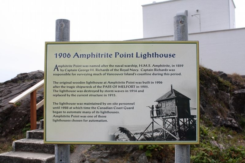
Amphitrite Point was named after the naval warship, H.M.S. Amphitrite, in 1859 by Captain George H. Richards of the Royal Navy. Captain Richards was responsible for surveying much of Vancouver Island's coastline during this period.
The original . . . — — Map (db m198567) HM
In 1952, the Kenney Dam was constructed on the Nechako River to service the new Alcan aluminum smelter at Kitimat, resulting in the creation of the Nechako Reservoir and the relocation of over 75 families. The damming also linked the rivers and . . . — — Map (db m8855) HM
In 1903, the land now occupied by the Butchart Gardens was purchased from a local dairy farmer, Mr. Fernie. Reservoirs were excavated in 1969 to ensure a water supply for irrigation. The single jet fountain was installed to aerate the water supply . . . — — Map (db m74459) HM
This pond was designed by Mr. Butchart for his collection of ducks in 1931. Beyond is the entrance to the Italian Garden through a Lawson cypress hedge. — — Map (db m74549) HM
The deepest part of the quarry floor was sealed, lined and allowed to fill with water from a natural spring forming a lake 40 ft deep in places. Mr. Butchart stocked the pool with trout which would rise to the surface to be fed when he clapped his . . . — — Map (db m74438) HM
The first permanent lighthouse on the Pacific coast of Canada, Fisgard was erected in 1859-60 by the British and Colonial Governments to guide mariners into Esquimalt Harbour. Brought from England with the first lightkeeper, the lantern became . . . — — Map (db m70876) HM
To seaward lies an anchorage or roadstead first used in 1790 by the Spanish and named in 1846 for its location between Albert Head and Victoria. Unloading place for large vessels serving Victoria in days of sail, it was once a scene of disaster. On . . . — — Map (db m72871) HM
Here, the mouth of the river is known as diitiida (Drifted Ashore) to the Pacheedaht (People of the Seafoam), and Ditidaht First Nations. At this ancient origin site, the two groups lived together as one people before the Great Flood. Spanish . . . — — Map (db m187889) HM
Before town planning and notions of the picturesque, waterfronts were convenient for industrial development. As a transportation hub, Sidney's waterfront boasted a sawmill, a cannery, boatworks and roofing plant, besides rail and ship . . . — — Map (db m75465) HM
If the Oceans of the world perish, so shall we. This mural was painted in celebration of the "International Year of the Ocean", and is a brief glimpse into the story of ocean science on the west coast. A mere fraction of the story is . . . — — Map (db m75463) HM
The harbours at Victoria and Esquimalt, and the adjacent coastline were defended by temporary gun emplacements from 1878. International crises during the latter part of the century led to an agreement between the Canadian and British governments . . . — — Map (db m75210) HM
Defence Electric Lights on both sides of Esquimalt Harbour entrance were used to illuminate targets for the guns at night. Engine rooms generated power for the lights. Lights and engines were controlled from this Defence Electric Light . . . — — Map (db m99440) HM
For many years, keepers tended this light. Now we tend the stories of the light.
Pendant bien des années, des gardiens ont veillé à entretenir cette lumière. À présent, nous veillons à immortaliser les récits sur ce phare.
[Background photos of . . . — — Map (db m99182) HM
Fisgard Lighthouse was built in 1860 as the first permanent light on the west coast of Canada. Although administered together with Fort Rodd Hill, it is a separate national historic site. There is no historic connection between the two . . . — — Map (db m75218) HM
Imagine the expanse of water between Fisgard Lighthouse and Albert Head (to your right) filled with ships at anchor. Named “Royal Roads” in colonial times, this was a safe anchorage, a place to wait for daylight, calm seas . . . — — Map (db m99180) HM
During the Second World War, steel mesh anti-torpedo and anti-submarine nets and a log-boom, were erected between this shore and the island occupied by Fisgard Lighthouse, and across to Duntze Head on the opposite side of the harbour. The . . . — — Map (db m98995) HM
The first Royal Navy warship dropped anchor in Esquimalt Harbour in 1848. Since then, the harbour has witnessed a fascinating evolution of naval power. Though global politics and weapons systems may change, Esquimalt remains a major strategic . . . — — Map (db m99461) HM
To commemorate the contribution made by ships and men to the naval service of Canada for seventy year since it was founded on 4th May, 1910.
Since November, 1910 when H.M.C.S. Rainbow arrived in Esquimalt, ships and men of the R.C.N. have been . . . — — Map (db m48716) HM
During the Second World War, a total of 17 modern searchlights replaced the four original defence electric lights. The 60-inch searchlight mounted in this emplacement was one of two installed at Fort Rodd Hill in 1940. Two similar . . . — — Map (db m98994) HM
Turkey Head was known by the indigenous people as Spewhung.
A large shell-midden along this shoreline indicates that this was an ancient village site to which first peoples brought many fish, bird, mammal and plant resources. Food was . . . — — Map (db m75329) HM
A rowboat was the only link between lighthouse and land, and sometimes the only thing standing between life and death.
Seule une chaloupe reliait le phare à la terre ferme, et c'était parfois l'unique moyen de rester en vie. . . . — — Map (db m99060) HM
These plaques commemorate famous vessels in
the history of Victoria and pay tribute to
pioneers they brought to this new land, the
men and women who fought the good fight
and built Victoria and British Columbia.
This key plaque . . . — — Map (db m231567) HM
This viewpoint illustrates the commanding position required for a coast defence gun battery. The trees in front were topped when the emplacement was in use.
A total of 27 locations were occupied by the coast defences between 1878 and 1956. . . . — — Map (db m99460) HM
This small islet and the adjacent shore were once an indigenous encampment connected with the village at McNeill Bay, Chikawich, to the west. The people living here ate over 20 species of fish and 15 species of birds, as well as deer, sea . . . — — Map (db m75340) HM
13 gun – 1034 ton
Naval Cadet Training
3 masted screw corvette
Commanded by Capt. Norimichi Aiura
Imperial Japanese Navy
First Japanese naval vessel to visit Canadian water 10 June 1880
Erected on the occasion of the visit of the Japan . . . — — Map (db m48715) HM
How did people navigate this coastline before lighthouses and GPS?
Comment les gens naviguaient-ils le long de la côte avant les phares et le GPS?
————————————— . . . — — Map (db m99204) HM
Presented to the City of Victoria
by the
Maritime Museum of British Columbia
28th July, 1966
H.M.S. Algerine was the last ship of the Royal Navy to be based in Esquimalt, 1908-1914. Transferred to the Royal Canadian Navy, she served as Depot . . . — — Map (db m49081) HM
This tree and anchor dedicated to the City of Victoria celebration of the 75th Anniversary of the Canadian Navy by HMCS Malahat 21 April 1985.
Rededicated on 3 May 1998 in celebration of the Naval Reserves’s 75th Anniversary
This historic . . . — — Map (db m49078) HM
Came with their five children from Papa Westray, Orkney Isl[ands]. aboard the sailing ship Knight Bruce via Cape Horn. Arrived at Victoria on 24 Dec 1864 after 180 days at sea. — — Map (db m74706) HM
ca. 1860
[Photo caption reads] A detail of the View of Victoria, 1860.
Major Bay is largely undeveloped.
BC Archives POP01538
1878
[Photo caption reads] Bird's-Eye View of Victoria, Vancouver Island, B.C. 1878, detail.
Drawn . . . — — Map (db m74383) HM
This building was constructed in 1924 as the
Canadian Pacific Marine Terminal building.
Designed by the architectural partnership
of F.M. Rattenbury and P.L. James it became
headquarters for the Canadian Pacific
British Columbia Coast . . . — — Map (db m118545) HM
A sports field served James Bay for many years until the Community envisioned a new park space. On August 27th, 2009 City Council adopted the Fisherman's Wharf Management Plan. The plan was completed in two phases and the Mayor celebrated the . . . — — Map (db m74385) HM
Down river lay the perilous and unnavigable canyon. Up-river the Fraser was swift and strong, but sternwheelers could travel for 400 miles from Soda Creek. Men and supplies embarked here in the 1860's for the fabulous Cariboo goldfields. Later, as . . . — — Map (db m187977) HM
When hydro-electric power was first delivered from No. 1 plant to Rossland's mines in 1898, the 32-mile transmission lines were the longest on the continent. Utilizing the 360-foot drop from Kootenay Lake to the Columbia River, additional . . . — — Map (db m187946) HM
It was the dream, in the 1880's of W.A. Baillie-Grohman, British sportsman and financier, to reclaim these fertile flats from the annual river floods. His canal at Canal Flats diverted part of the Kootenay into the Columbia but was abandoned. The . . . — — Map (db m188032) HM
For 1200 miles, in two countries, the Columbia carves its way to the Pacific Ocean. Named after Robert Gray's ship the "Columbia", it was first mapped in 1811 by David Thompson. This "highway" for traders, missionaries and gold miners later became a . . . — — Map (db m187966) HM
In 1808 David Thompson named this flat “McGillivary's Portage” as he crossed from Columbia Lake to the Kootenay River. In 1889 W.A. Baillie-Grohman joined the two waterways by a canal with a single lock. Regulations aimed at preventing Columbia . . . — — Map (db m188022) HM
A colourful steamboat era preceded the railways. During mining boom days of 1893-98 a fleet of sternwheelers ran north from the railway at Jennings, Mont., to Ft. Steele and vicinity.
Carrying prospectors, freight, and ore they battled . . . — — Map (db m187987) HM
In 1924, by a system of stream diversions, dams, dykes, canals and pumps, 33,000 acres of fertile land were reclaimed from Sumas Lake. Few areas in B.C. have such rich soil with transportation and markets in close proximity. Produce of the mixed . . . — — Map (db m187960) HM
River Routes
Located near the intersection of the King George VI Highway and the Nicomekl River, the Port Elgin area has been a crossroads for various forms of traffic for thousands of years. For centuries prior to the arrival of the first . . . — — Map (db m63715) HM
From 1889, sternwheelers and smaller craft fought their way through the Coast Mountains, churning past such awesome places as “The Devil's Elbow” and “The Hornet's Nest”. Men and supplies were freighted upstream, furs and gold downstream. A quarter . . . — — Map (db m187963) HM
Head of sternwheeler navigation on the Skeena. The town grew at the landing close to the Indian village of Gitenmaks. Crews from the Collins Telegraph arrived in 1866. Following them Omineca gold miners, Hudson’s Bay pack strings and “gandy . . . — — Map (db m9073) HM
The Gitxsan are people of the Skeena River or River of Mist. For 10,000 years the Gitxsan have dwelled in their traditional territory and today approximately 13,000 members live in communities known as Gitwangak, Gitanyow, Gitsegukla, Hagwilget, . . . — — Map (db m187933) HM
Cascade came into being during the late-1890s as a bustling railway construction town claiming 17 hotels at its height. Its location along the Canada-U.S. border proved strategic for mining, freighting, and hydro-electricity. The early development . . . — — Map (db m187915) HM
This site, on the world's greatest salmon river, lured many pioneer canners in the late 1860's and early 1870's. Pre-eminent was Alexander Ewen, a founder and first president of B.C. Packers, who established a cannery here in 1871. The new salmon . . . — — Map (db m187923) HM
Colonel R.C. Moody, R.E., recognized the potential value of Burrard Inlet for military defence. Named in his honour, Port Moody became the western terminus of the Canadian Pacific Railway. Although a branch line was built in 1887 to the growing city . . . — — Map (db m187971) HM
During its heyday, the Brockton Point Lighthouse played a key role in guiding ships safely in and out of Coal Harbour.
Early Warning System
The first Brockton Point lighthouse, built in 1890, alerted ships to shore-related dangers and . . . — — Map (db m198612) HM
Built to service the trading forts of the Hudson's Bay Company, the BEAVER regularly steamed the H.B.C.s territory between Puget Sound and Russian Alaska for 24 years. In 1862, the BEAVER was chartered to the Royal Navy and, after a refit, began a . . . — — Map (db m236206) HM
The local Coast Salish people gathered clams and mussels along these shores when this lagoon was a saltwater inlet of Coal Harbour.
[caption] Lost Lagoon got its name in the earl 1900s from Canadian poet Pauline Johnson, who presented the name . . . — — Map (db m236365) HM
Canada Pacific Railway Station
Architects: Barott, Blackader & Webster
As the terminus for the Canadian Pacific Railway, this site has been an important landmark since the completion of the railway in 1886. This Neo-Classical . . . — — Map (db m236312) HM
Canada Place was the Canadian Pacific Railway's Pier B-C ocean liner terminal in the 1920s. In 1982, the Government of Canada redeveloped it as the Canadian Pavilion for The Expo '86 World Fair and dedicated it as a legacy for the Canadian people. . . . — — Map (db m236308) HM
As ships navigated the Narrows' powerful tidal flows, they relied on warnings from the Prospect Point Lighthouse to stay clear of its rocky hazards.
Response to Disaster
In 1888, just off this point, the historic steamship S.S. Beaver ran . . . — — Map (db m198611) HM
In the area then known as West Capilano, and today as Ambleside, a former Canadian Pacific Railway conductor. John Lawson, purchased land in 1906. He moved his family there the following year, Lawson had big ideas for his land, which he christened . . . — — Map (db m235892) HM
This grassy area, now Devonian Harbour Park, represents lavers of historic use from early settlement to industrial waterfront.
Coal Harbour
In 1859 Captain George Henry Richards from the British Royal Navy named this bay Coal Harbour, . . . — — Map (db m235893) HM
Her Majesty's Canadian Ship Discovery was commissioned on November 1, 1941. Thousands of men and women have been recruited and trained at these naval reserve facilities of Deadman's Island for service to Canada in peace and war.
World War . . . — — Map (db m236197) HM
On May 23, 1914, the steamship Komagata Maru arrived in Coal Harbour after a seven week crossing from Hong Kong via Japan. The ship was carrying 376 Indians from India and the Far East who claimed right of entry as citizens of the British Empire. . . . — — Map (db m236311) HM
The Guinness brewing family built the Lions Gate Bridge which opened in 1938 to provide access to its British Properties lands in West Vancouver. Ownership was transferred to the Province in 1955. Tolls were removed in 1963 and the bridge was . . . — — Map (db m236789) HM
You can thank Vancouver's early shipping activities for this viewpoint -originally the site of a signal station that guided ships through First Narrows.
Towering Beacon of Safety
A two-storey signal station once sat atop . . . — — Map (db m236128) HM
Captain George Vancouver R.N.
June 22nd 1757 May 12th 1798
On June 12th, 1792 Captain George Vancouver, R.N. celebrated mariner and intrepid explorer, under authority of his majesty King George III of England, sailed into . . . — — Map (db m236650) HM
Site named by Capt. Vancouver June 14, 1792
Wall of original tower, built in 1874, still
stands near present tower, completed in 1912
Tower 60 ft high - light 108 ft above high water
light beam a 500 watt bulb
foghorn range - 10 miles . . . — — Map (db m198587) HM
[English] This lighthouse replaced an 1875 building of which the foundations of the keeper's dwelling survive. Built in 1912 by contractor W.H. Rourke, the hexagonal reinforced concrete tower, 18.3 metres high, is an early example of this . . . — — Map (db m198577) HM
The Okanagan nation knows Spotted Lake, just east of here, as K t li lxw. From time immemorial its healing waters and mud were used by First Nations to cure aches and illness, and for spiritual healing. High concentrations of Epsom . . . — — Map (db m187927) HM
In 1793 Alexander Mackenzie and North West Company adventurers discovered this route through the Rocky Mountains. During 1805-08 Simon Fraser built forts and trading posts west of the mountains. Furs of the Pacific watershed began moving eastward. . . . — — Map (db m187958) HM
In the summer of 2000, two young boys tubing down Flatbed Creek stumbled upon ankylosaur tracks - the longest dinosaur trackway in British Columbia at the time. This discovery was a turning point in the development of Tumbler Ridge and the Peace . . . — — Map (db m187874) HM
The Skeena, “river of mists,” makes a major cleft through the Coast Mountains. To Coastal Tsimshian Indians and Interior tribes it was vital to trade and travel. In later years, Port Essington, near the river’s mouth, became the main . . . — — Map (db m9074) HM
The prospect of quick riches lured hundreds of placer miners to the Cassiar, where gold was discovered first at Dease Creek in 1872. Rich claims were later found at Thibert Creek and here at McDame Creek. From this creek in 1877 a 72-ounce solid . . . — — Map (db m187916) HM
On July 13, 1792, the sloop Discovery, commanded by Captain George Vancouver, R.N., skirted Cape Mudge and entered the narrow, tide-ripped channels leading northward to the open Pacific. This perilous voyage through Discovery Passage and . . . — — Map (db m187975) HM
Treacherous currents, swirling eddies, and turbulent tide-rips still harass vessels, despite the blasting away in 1958 of the twin peaks of Ripple Rock. Charted in 1792 by Captain George Vancouver, the Narrows has claimed numerous ships and lives . . . — — Map (db m9077) HM
Strategically located at the narrowing of Johnstone Strait lie the intact remains of Canadian artillery defences. Built in 1937-1945, they deterred seaborne attacks on Vancouver during World War II. The island and its military legacy are protected . . . — — Map (db m187888) HM
Smooth rivers and great lakes once were the highways of travel. On them plied stately paddle-wheelers, helping exploration and settlement of the Interior. They speeded gold-seekers bound for the “Big Bend” rush of 1864-65. They freighted grain from . . . — — Map (db m187961) HM