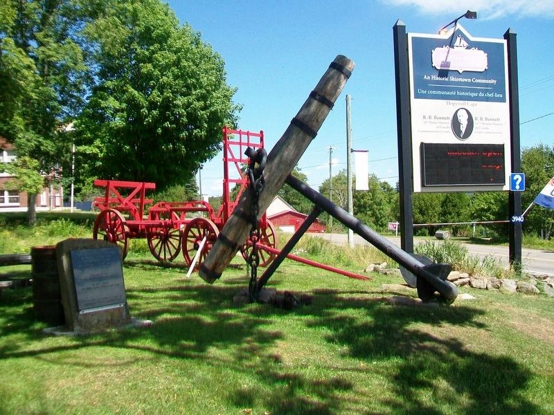
This 18th century anchor
retrieved from the
Petitcodiac River
at Hopewell Cape in 1981
by Jack Weldon
Donated to the
Albert County Historical Society
by
his wife Grace
and sons James, Thomas and Dale
This plaque was given as a . . . — — Map (db m106638) HM
(English:) Historic salmon harvesting area of First Nations People and Loyalists. In the first half of the 20th century, the pool became internationally renowned as a sport fisherman's paradise.
(Français:) Zone . . . — — Map (db m138996) HM
Named on June 24, 1604 – the feast day of St. John the Baptist – during the expedition of Sieur de Monts and Samuel de Champlain the river originates in northern Maine and flows 673 kilometers emptying into the Bay of Fundy at Saint . . . — — Map (db m138997) HM
• Settled 1802 by William Orser United Empire Loyalist near where the Becaguimac Stream flows into the St. John River
• Originally known as Mouth of the Becaguimac
• Becaguimac — Abekaquimek — Maliseet for salmon bed
• . . . — — Map (db m138999) HM
Built circa 1868 this house is considered to be the best example of High Victorian architecture in Woodstock. The house was built on land that was originally part of the grounds of the Honourable Charles Connell House. It is possible that . . . — — Map (db m139106) HM
English:
The precise mapping of Acadie in the 17th century was the work of one individual — Samuel de Champlain.
Between May 1604 and August 1605, travelling by barque, pinnace, canoe or on foot, Champlain surveyed and . . . — — Map (db m144500) HM
English
From the Chiputneticook Lakes, the waters of the St. Croix River tumble through rolling Appalachian scenery to one of the most historic estuaries in Canada, at Passamaquoddy Bay. Here, French colonization in North America began . . . — — Map (db m77395) HM
In the waters off New Brunswick you'll find magnificent creatures of the deep - among them, North Atlantic right whales, humpback whales and finback whales
In New Brunswick, we're proud to live along the beautiful shores of the Bay of Fundy, . . . — — Map (db m106917) HM
Although visitors had been coming to the island since 1855, Campobello's summer trade did not really prosper until the 1880s - years of long summer vacations and great resorts. A group of Boston and New York businessmen bought most of the . . . — — Map (db m63639) HM
Friar's Head takes its name from the stone pillar or stack (photo 1) that rises from the beach directly below the observation deck. While occupying Eastport, the British navy was said to have used the stone pillar for target practice, . . . — — Map (db m63629) HM
About 1840, a canal connecting Johnson and South Bays was dug in North Lubec and a dam constructed there to harness tidal energy to power plaster mills. Gypsum (the raw product used to make plaster) and grindstones from the Maritimes were important . . . — — Map (db m54995) HM
Lubec's known history began at a Passamaquoddy Indian encampment at Mill Creek in what came to be called Seward's Neck (now North Lubec). French settlers later came to those shores in the early 1700s, but shortly afterward were driven away by the . . . — — Map (db m55023) HM
[English version]
Built in 1885, the Mulholland Point Lighthouse guided many small coasters and freighters taking the shorter and foul weather-protected route through the narrow passage between Campobello and Lubec. Steamships, carrying freight . . . — — Map (db m54894) HM
Built in 1885, the Mulholland Point Lighthouse (photo 1) served as a guide for the many small coasters and freighters taking the shorter and more foul weather-protected route through the Lubec Narrows. Steamships, such as the . . . — — Map (db m63593) HM
During the years FDR summered on Campobello, the daughter of one of Campobello's summer colonists married Dexter P. Cooper, an eminent American engineer. Cooper studied the tremendous rise and fall of Passamaquoddy Bay's tides and became . . . — — Map (db m63611) HM
Passamaquoddy Bay takes its name from the Native American Passamaquoddy Tribe. The word means People of the Pollock-Spearing Place. The Passamaquoddy have a rich heritage, once occupying much of what is now eastern Maine and western New . . . — — Map (db m63617) HM
The Roosevelt Campobello International Park is a unique example of international cooperation - jointly administered, staffed, and funded by the peoples of Canada and the United States. Established by international treaty in 1964, the . . . — — Map (db m63591) HM
English:The MastsIn partnership with the Richibucto River Historical Society, the Kingston Maritime Association was organized in 2003 for the purpose of establishing a means of recognizing and preserving the shipbuilding history . . . — — Map (db m150501) HM
English: The village of Rexton was founded in 1825 and officially incorporated, as a village, in 1966. Rexton's population had reached 908 according to the 1996 census. Rexton is located in Southeastern New Brunswick, near the mouth . . . — — Map (db m150507) HM
English:Wooden Ships and Iron Men During the nineteenth century, New Brunswick's booming shipbuilding industry brought great prosperity to the Richibucto River. More than seventy ships of 500 tons and over were built and . . . — — Map (db m150504) HM
English:
Partridge Island has been home to natural and human communities for a long time.
It began about 300 million years ago when ash from an ancient volcano created the island. Sand and soil slowly built up, seeds took . . . — — Map (db m145599) HM
English:
From 1881 to 1960, a massive building with a central dome and two elaborate towers dominated the Saint John waterfront.
The Custom House was three storeys high on Prince William Street and five storeys on Water . . . — — Map (db m145399) HM
English:
Born to a wealthy American family in 1736, Gabriel Ludlow grew up a supporter of the King. When the American Revolution came Ludlow raised a battalion for General DeLancey's Brigade. He was commissioned colonel of the . . . — — Map (db m141992) HM
English:
Saint John Harbour has long been strategically important. There are many sites in and around the harbour relating to its defense — from Fort Saint Marie, now known as Fort LaTour, a fortified fur-trading settlement . . . — — Map (db m145591) HM
English
The first vessel in the world propelled by a compound steam engine was the REINDEER launched for service on the Saint John, in 1845. Both the vessel and engine were designed by Benjamin Tibbets, a native of Queen’s County, New . . . — — Map (db m77428) HM
English
In 1854, Robert Foulis of St. John, N.B., first advocated the use of a steam horn or whistle to give warning to vessels in foggy weather. An apparatus devised by him was installed on Partridge Island in 1859. This was the first . . . — — Map (db m77430) HM
English:
For at least 10,000 years the Saint John harbour and river estuary, with its rich range of maritime food resources, from shellfish to walrus, provided abundantly for the Wolastoqiyik (Maliseet) and their ancestors. . . . — — Map (db m147795) HM
English:
At age 16 John Robertson left Scotland for Saint John to work as his uncle's clerk. From his arrival in 1817 Robertson's energy, vision and shrewd business sense were combined with significant social skills. People liked . . . — — Map (db m141994) HM
English:
Koluskap and Beaver
The following is a creation story kept by the storytellers of the Wolastoqiyik (Maliseet) about their ancestors in the communities of the Wolastoq (St. John River) where it meets the Bay of . . . — — Map (db m141909) HM
English:
Land of the Dawn
The traditional territory of the Wolastoqiyik is called Wabanaki (Land of the Dawn). Wolastoqiyik, people of the beautiful river, have been here since the beginning. In the beginning the river . . . — — Map (db m141443) HM
English:
Look toward the mouth of the harbour and you'll see Partridge Island, an official National and Provincial Historic Site. Only 600 metres (654 yards) long by 300 metres (327 yards) wide, the rocky island was home to . . . — — Map (db m145596) HM
English:
Partnership at Portland Point
In August 1775 the 140 residents of Portland Point were attacked. A Machias war sloop burnt Fort Frederick, carried off its four soldiers and a ship full of supplies from the upriver . . . — — Map (db m141990) HM
English:
In 1822 when Robert Foulis arrived in Saint John, New Brunswick he was 30 years old, a well-educated Scotsman from Glasgow, recognized as brilliant in sciences, and trained as an engineer. He spent the rest of his life in . . . — — Map (db m141998) HM
English:
For more than two hundred years the City of Saint John and its sheltered, ice-free port, have been critical to the economic success of New Brunswick. Historically providing a port of entry for people and products, the . . . — — Map (db m145394) HM
English:
Saint John Harbour has been a strategic military site from the 1600’s through 1945. Each conflict led to the construction of defensive installations reflecting changing naval technologies.
Français: . . . — — Map (db m145597) HM
English:
On March 7th 1604, Samuel de Champlain, map-maker for Henry IV of France, sailed for L'Acadie with its newly appointed Lieutenant-General, Pierre du Gua de Monts. A second ship followed with Pont-Gravé who had explored . . . — — Map (db m141299) HM
English:
Where does a nickname come from?
No one can say why the Three Lamps light is better known as The Three Sisters. Nevertheless, local residents know the landmark by its nickname and have many stories to explain it. . . . — — Map (db m145600) HM
English:
In 1762 three young ex-officers of provincial regiments (units of Americans within the British army) joined in a trading venture. The Boston friends - James Simonds, James White and William Hazen - were attracted to the . . . — — Map (db m141991) HM
1842 • A navigational signal lamp was erected on this site
1847 • A single gas lamp was erected by the Saint John Gas Co. and dedicated to the harbour pilots of Saint John
1848 • The Saint John Gas Co. commissioned Alexander . . . — — Map (db m145598) HM
English
A three-masted full-rigged ship with a modified clipper hull, the Marco Polo earned a reputation as the “fastest ship in the world” and drew international attention to New Brunswick shipyards. Built in 1851 by . . . — — Map (db m77456) HM
English:
Imagine the harbour full of sails, wooden vessels of every shape and size navigating the tricky tidal currents to enter port.
Imagine the snap of the canvas and the shouts of sailors dropping the massive sheets to . . . — — Map (db m145400) HM
(English:)The Marco Polo and the Golden Age of Sail The Fastest Ship in the World Saint John, New Brunswick, Canada In the background you can see Saint John as it appeared in 1851, twenty-six years before the great fire of 1877 . . . — — Map (db m138894) HM
English:
The St. John River, with its long interior waterways, deep and sheltered harbour, and connection to the oceans of the world, is a natural highway for those travelling with the flow of the river. However, for those . . . — — Map (db m147796) HM
English:
The tides in the Bay of Fundy are among the highest in the world, reaching 16 m (53 feet) at the head of the bay. Closer to the mouth, the tidal range is less. At Saint John it averages 7 m (23 feet), still enough to . . . — — Map (db m147800) HM
This plaque is in commemoration of the firm of Messrs. Troop and son, shipowners in the city of Saint John, New Brunswick, where the business of the firm was carried on during the years 1847-1912. Founded by Jacob V. Troop, the business was . . . — — Map (db m77459) HM
English:
West meets East… by Harbour Ferry
Long before a bridge spanned the harbour, passenger ferries linked the east and west sides of Saint John.
From 1841 to 1954, eight different ferries provided service between . . . — — Map (db m145398) HM
English:
Wolastoq Park The Name
Wolastoq means "the Beautiful River" in the language of the Maliseet people who lived beside it. Today, we know it as the beautiful St. John River. For many centuries before Europeans arrived . . . — — Map (db m141298) HM
English: From its origins in the late 18th century, the shipbuilding industry profoundly influenced New Brunswick history. Craftsmen in the colony built over 6,000 vessels during the 19th century, a third of the total tonnage produced in . . . — — Map (db m137643) HM
During the spring freshet, 6000 m3 or six million litres of water, 9/10ths the volume of Niagara Falls, cascades over the falls every second. A few months later, virtually all the water is diverted to the power plant. . . . — — Map (db m125521) HM
Oran B. Davis, a wealthy lumberman, had this area cleaned and opened it to the public. There are several historic monuments to be seen. The beautiful shady walk gives an excellent view of the falls and dam. . . . — — Map (db m125516) HM
English: From the bygone days of New Brunswick's "Golden Age of Sail", its once-prosperous commercial fishery, and its growing tourism and ecotourism industry, the Petitcodiac River continues to play an important role in the . . . — — Map (db m150992) HM
English: Historically, the Petitcodiac River was home to a large number of fish species. Both the rainbow smelt and Atlantic tomcod numbered in the hundreds of thousands. There were healthy populations of gaspereau, American eel, . . . — — Map (db m150985) HM
English: The Settlers of the Township of Monckton reached their destination after 44 days at sea, on June 3, 1766. Captain Jonathan Hall guided the sloop along Pennsylvania's Schuylkill River to the New England coast, then entered . . . — — Map (db m151002) HM
English: 1 • This journey began in Europe where eight families, seven of German origin, and one of Welsh origin, set out to seek a new homeland. It ended here, on these muddy Banks of the Petitcodiac River, when the families of . . . — — Map (db m151001) HM
English: In honour of the permanent settlers of the Monckton township, the Stief, Lutz, Treitz, Jones, Sommers, Copple, Ricker and Wortman families who came up the Petitcodiac River from Pennsylvania and landed on the bank of this . . . — — Map (db m151000) HM
English: The Peter McSweeney Company Limited (700 Main) offered a special sale called the Red and Green Tag Campaign twice a year, when the tides allowed customers to arrive by ship in the morning to go shopping and return home in . . . — — Map (db m150997) HM
English: Because of access to the Atlantic Ocean and an abundance of timber, communities along the Petitcodiac, like others in New Brunswick, flourished during the "Golden Age of Sail". It began as early as 1827, when Moncton was . . . — — Map (db m150981) HM
English: Powered by the high tides of the Bay of Fundy, the tidal bore has fascinated visitors and residents for generations. It was considered one of the top tidal phenomena in the world until the construction of a causeway in the . . . — — Map (db m150960) HM
This garden is named in honour of HMCS Sackville, a corvette that had a distinguished career during the Second World War. She was launched on May 15, 1941 in Saint John, New Brunswick and was christened by Mrs. J.E.W. Oland in the . . . — — Map (db m106595) HM WM