You are now on the great divide which separates the two principal drainage areas of Wisconsin. Water falling to the north of this point finds its way into Lake Superior, then down through the Great Lakes and the St. Lawrence River 2,000 miles into . . . — — Map (db m47222) HM
Native American canoes launched North America’s maritime legacy about 12,000 years ago, making them among the world’s oldest watercraft.
The origins of the birchbark canoe are told in the oral traditions of the Ojibwe people. The spirit . . . — — Map (db m57836) HM
You might know that Lake Superior is the largest body of freshwater in the world, but did you know that it is large enough to generate its own small tide?
This tidal action, called "seiche,” influences Fish Creek. At times, water from Chequamegon . . . — — Map (db m201391) HM
VOICES IN THE MIST
When the mist turns a waltz along the shoreline, and swirls heavenward via convection, lend your ears to the bay. There are forms in the mist, and in the forms there are faces. The faces smile, and the hint of a melody plays . . . — — Map (db m201384) HM
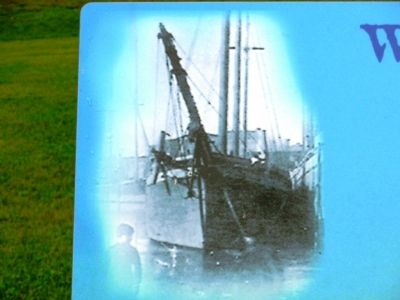
Bayfield’s history has been powerfully shaped by its location. Situated on the shores of a deep, natural harbor, the city is sheltered from Lake Superior’s notorious storms by the outlying Apostle Islands. Lighthouses, shipwrecks, and a historic . . . — — Map (db m57835) HM
Dedicated in 1981 to the hard working commercial fishermen whose indomitable spirits will not be forgotten.
Commissioned by Edwin Erickson,
Mayor of Bayfield, 1970-1976 & 1980-1988
Designed by Harold Kerr (1909-1981)
Constructed by . . . — — Map (db m57811) HM
Listed on the National Register of Historic Places
In the waters off Outer Island lies the wreck of the Pretoria, one of the largest wooden vessels ever to sail the Great lakes. On September 1, 1905, Captain Charles Smart and nine crew . . . — — Map (db m98244) HM
At one time, a local fishery once encompassed this entire block. Early sailing vessels would bring their harvests here to be salt packed in barrels and shipped to market. Here in “The Cooperage,” one of the remaining buildings of that . . . — — Map (db m57810) HM
Leo, Roy, and Eskel Hokenson began fishing commercially at Little Sand Bay in the 1920s. During the fall herring season, the brothers fished at night when cooler temperatures helped preserve the catch. Noting this habit, friends began saying, . . . — — Map (db m201397) HM
Harvesting the Waters
In 1927, the Hokenson brothers (Leo, Roy, and Eskel) began life as fishermen. For more than 30 years, they met the challenges of fishing the largest lake in the world, relying on their skills, strength, and . . . — — Map (db m46908) HM
Type: Steel, bulk and package freighter
Built: 1890, Frank W. Wheeler, Bay City, Mich.
Sank: September 2, 1905
Length: 372’ Beam: 41’
Cargo: Iron ore
Propulsion: Propeller
Depth of Wreckage: 25’
Lives Lost: 7
Listed on the . . . — — Map (db m46907) HM
In the early days of Washburn, the waterfront was filled with saw mills. The A.A. Bigelow Mill (1887-1902), later to become the Hines Mill, was the largest of three major sawmills in Washburn. It rested on pilings that ran directly out from the . . . — — Map (db m122317) HM
(side 1)
Washburn Lumbering Days
Washburn begins on the shoreline of Chequamegon Bay. The city rises gradually 75 ft. above level of the water. In 1884, the town was created, born of the necessity of the railway (Chicago, St. Paul, . . . — — Map (db m57824) HM
is the most cost-effective mode of transportation when compared to truck or rail. Ships quietly move cargo farther (per ton mile) and more efficiently than trucks or trains. Most importantly, ships move cargo more safely than trucks and trains. . . . — — Map (db m43814) HM
The rapids at De Pere were well known to all early travelers along the Fox and Wisconsin rivers, which provided the best access to the Mississippi. Despite Indian domination, the waterway served explorers, fur traders and voyageurs, missionaries, . . . — — Map (db m11053) HM
The Fox River has served as a highway for the movement of people and goods for thousands of years. Archaeologists working along the Fox River in De Pere uncovered two-thousand-year-old pottery that demonstrates trade with communities in Illinois. . . . — — Map (db m189977) HM
in Wisconsin’s transportation system is the Port of Green Bay. It serves as a multi-modal distribution center connecting waterborne vessels with an extensive network of highways and railroads. The Port of Green Bay provides Northeast Wisconsin . . . — — Map (db m43812) HM
is a vital part of our local economy, our history and our lives. It plays an important role in the transportation of goods and commodities that are critical to the economic health of the region. The Port of Green Bay receives and/or sends . . . — — Map (db m43817) HM
and geographic location is everything. The sparkling waters of Green Bay and sweeping rivers feeding into it
have attracted numerous industries over the past few hundred years. The French fur-trading empire of the
early 1700s gave way to . . . — — Map (db m43819) HM
The Beef Slough was a sluggish branch of the Chippewa River that provided an excellent storage pond for the logs floated downstream by numerous logging companies. Here loggers were employed to arrange the mixed-up logs into orderly rafts to be towed . . . — — Map (db m10103) HM
Designed by and constructed under the direction of
The Corps of Engineers, United States Army
1932 – 1935
Contractor for lock – Ouilmette Construction & Engineering Co.
Contractor for dam – United Construction Co. . . . — — Map (db m17300) HM
The St. Croix River winds its way through wild and scenic countryside from its origin in a Spruce-Tamarack swamp near Upper St. Croix Lake. The waters of the Namekagon join the St. Croix 45 miles upstream from this sign. The river system varies from . . . — — Map (db m44547) HM
Around A.D. 1100, there was a large Native American village on the north side of Stockbridge Harbor. The pottery recovered from archaeological excavations at this site indicates that the villagers came from two formerly distinct cultural groups. . . . — — Map (db m31799) HM
He gave his life to the Jaycees and to his community, in the belief that service to humanity is the best work of life. We shall not forget...
Ronald P. Anders Memorial Pure Water Fountain was constructed by the Chippewa Falls Jaycees and . . . — — Map (db m41525) HM
William Irvine was born in Mount Carroll, Illinois of Scotch-Irish ancestry. He came to the Chippewa Valley when he was 14 years old to work for his brother-in-law, who was captain of a raft boat towing lumber from Chippewa Falls to Mississippi . . . — — Map (db m38788) HM
This tablet was erected in 1931
by The Women's Club of
Cornell, Wisconsin
and serves a twofold purpose.
—
On the hillside below, unmarked and obliterated, are many Indian graves of days long past. At a later period this plot . . . — — Map (db m46047) HM
Jean Brunet is one of the most noteworthy pioneers of the Chippewa Valley. Born in France in 1791, Brunet immigrated to this country in 1818 and moved to Chippewa Falls in 1828. He built the first dams on the Chippewa River at Chippewa . . . — — Map (db m46018) HM
On July 7, 1905, sixteen loggers of the Chippewa Lumber and Boom Company attempted to break a log jam on the Chippewa River at Holcombe below Little Falls dam, one of the largest wooden dams in the world. The batteau boat they were riding in reached . . . — — Map (db m45434) HM
The Holcombe Indian was known to river men along the Chippewa since 1876. Called the King of the Chippewa River, he stood guard on the old Holcombe (Little Falls) Dam and was a most welcome site to lumberjacks driving their logs down the river to . . . — — Map (db m45431) HM
Side A Neillsville has strong ties to the majestic white pine forests of the Wisconsin Territory. These forests along the Black River and its tributaries drew members of the Church of Jesus Christ of Latter-day Saints in 1841. Remembered . . . — — Map (db m185567) HM
At this location, in 1846, Alfred A. Brayton constructed a log and earth dam across the Crawfish River and erected a saw mill.From this saw mill the village of Fall River was built. — — Map (db m150747) HM
Merrimac’s first permanent settler, Chester Mattson, obtained a territorial charter in 1848 to provide ferry service across the Wisconsin River. The State Legislature of 1851 authorized a road, subsequently to become State Trunk Highway 113, to . . . — — Map (db m1932) HM
Ketchum’s Point, named for a local family, stands above the low, marshy Portage connecting the Fox River and Great Lakes with the Wisconsin and Mississippi rivers. This waterway served as a vital thoroughfare for supplies and furs during the fur . . . — — Map (db m2407) HM
On June 14, 1673 Jacques Marquette and Louis Jolliet started the portage (1.28 miles) from here to the Wisconsin River, which led to their discovery of the Upper Mississippi June 17, 1673 at Prairie du Chien. The expedition, in two birch bark . . . — — Map (db m2341) HM
Landing place of the ferry built by Pierre Pauquette and operated by him from about 1828 until his death in 1836. This ferry was in use until the first bridge was built across the Wisconsin River in 1857. — — Map (db m74344) HM
Near here in 1849 Thomas Twiggs began a settlement of unemployed potters from Staffordshire, England. To help farmers on both sides of the Fox River reach his store and blacksmith shop at Twiggs' Landing, he operated Emancipation Ferry, named to . . . — — Map (db m20084) HM
Before the introduction of the railroad, the Wisconsin River
provided one of the most practical means of transporting lumber
and farm products to distant markets. The old Village of Dekorra was
beautifully situated to take advantage of this . . . — — Map (db m165534) HM
In 1873, steamboats began overtaking rowboats for river excursions to see the famous Dells. One such steamer was built in 1878 by the Kilbourn Boat Company and named after Alexander Mitchell, a successful Milwaukee banker and railroad magnate. By . . . — — Map (db m156991) HM
This natural harbor is named for Gen. Joseph Bailey, original owner of the property. It has been the gateway to the magnificent dells of Wisconsin for millions of visitors for over 100 years. Sight-seeing boats have developed from spoon-oared . . . — — Map (db m7757) HM
This building was constructed on the home site of General Joseph Bailey Civil War hero and a founder of Kilbourn City (now Wisconsin Dells) in 1856. Bailey became a national Civil War hero in 1864 when Porter's Red River Fleet was stranded in low . . . — — Map (db m7966) HM
The word "Dells" was derived from the French word "Dalles," meaning flat-layered or slab rock. These layers of rock were formed during the Cambrian period, 500 million years ago, when the North American Continent was completely covered by an ocean, . . . — — Map (db m157040) HM
A Wisconsin Pioneer
One of the founders of Wisconsin Dells, Joseph Bailey completed the first dam across the Wisconsin River here in 1859. Opposition from upriver lumbermen required the dam's removal in 1860. Bailey's dream to build an . . . — — Map (db m134610) HM
In 1634, Jean Nicolet was the first white man to have contact with the Indians of Wisconsin. He was soon followed to this area by French and British explorers, missionaries, adventurers and fur traders. The first white settlers came in the 1840's . . . — — Map (db m157039) HM
(two panels, side-by-side)
Indians
Indian tribes have lived in this area of Wisconsin for centuries. Jean Nicolet, a French Government representative, was the first white man to have contact with the Indians in 1634. . . . — — Map (db m157082) HM
River excursions in Wisconsin Dells were born from one man's a-ha moment. Leroy Gates gained notoriety as an expert lumber raft pilot, guiding the bundled wood planks through the tricky waters of the Dells. He began to make a show of his skills, . . . — — Map (db m157036) HM
The year 1908 brought dramatic changes to the Wisconsin River and the Dells. After many attempts at harnessing the power of the river with smaller dams, a new high dam and hydroelectric power plant were built. The Kilbourn Dam split the river into . . . — — Map (db m157126) HM
Picture before you a white-rapids river raging between its rocky banks. The early days of the Wisconsin River flowing through this region were not the serene postcard scenes of today. The riverbed and towering sandstone bluffs were formed more than . . . — — Map (db m157037) HM
After 1837 the vast timber resources of northern Wisconsin were eagerly sought by settlers moving into the mid-Mississippi valley. By 1847 there were more than thirty saw-mills on the Wisconsin, Chippewa, and St. Croix river systems, cutting largely . . . — — Map (db m23456) HM
In 1673, Louis Jolliet, Canadian fur-trader and explorer, and Father Jacques Marquette, French Jesuit Missionary, with five French Canadian boatmen, were the first white men to enter the upper Mississippi River.
Indians directed them to the . . . — — Map (db m43530) HM
In the summer of 1823 the steamboat Virginia
successfully negotiated the dangerous rapids at the
mouth of the Des Moines River and became the first
steam-powered vessel to navigate the upper
Mississippi.
By the 1830’s steamboats were common . . . — — Map (db m125202) HM
This land was bequeathed to the Madison Park and Pleasure Drive Association in 1909 by one of its active members, George B. Burrows (1832 - 1909). The lake shore area was filled to its present level by dredging the lake bottom. Until 1913 an on-site . . . — — Map (db m44408) HM
Once a marshy area off the shores of Lake Monona, this triangular shaped neighborhood became a dream for Italian immigrants during the early 1900's. Greenbush developed into one of America's countless Little Italys, complemented with Jewish, Black . . . — — Map (db m32636) HM
This causeway overlooking Lake Monona and downtown Madison is named after John Nolen (1869-1937). A nationally known landscape architect, Nolen was retained by the Madison Park and Pleasure Drive Association to study ways to make the city more . . . — — Map (db m32731) HM
Originally built in the early Romanesque Revival style, this house was altered in 1870 by the addition of a mansard roof. The Milwaukee cream brick structure was built for, but never occupied by, Napolean Bonaparte Van Slyke, first cashier of the . . . — — Map (db m32383) HM
James R. Law (1885-1952) was the founder of Law, Law, and Potter, an architectural firm that designed many buildings and homes in Madison. Law was appointed mayor in 1932 and was re-elected for 5 terms. In 1943 he resigned to become chairman of the . . . — — Map (db m36167) HM
The first plan for a sewage system in Madison was adopted in 1885. The system first pumped untreated human waste directly into the lakes.
It wasn't until 1901 that a sewage treatment facility was built. By then Lake Monona and the surrounding . . . — — Map (db m39102) HM
In 1846 Wisconsin's territorial legislature approved incorporation of Madison Village and construction of a dam at Lake Mendota's outlet with a canal for navigation between Lakes Mendota and Monona.
The first dam was built of earth in 1847 by . . . — — Map (db m33652) HM
The Lewis Nine Springs E-Way
The original vision for the Nine Springs E-Way began in 1970 as a demonstration project funded by the National Endowment of the Arts. In 1971, Dane County adopted the "Environmental Loop Plan". After a series of . . . — — Map (db m195471) HM
These two Mediterranean Revival mansions were designed for Magnus and Annie Swenson and their daughter Mary North by Madison architects Law and Law. Swenson was a Norwegian immigrant who became an internationally famous inventor and humanitarian. . . . — — Map (db m46031) HM
Madison was little more than a few buildings and a swamp in 1847 when Leonard Farwell bought large amounts of land here. Orphaned at 11, Farwell built a very successful hardware business in Milwaukee while still in his 20s. He would soon transform . . . — — Map (db m32953) HM
In January 1903, the leader of Madison's park development and President of the Madison Park and Pleasure Drive Association, John M. Olin, presented a grand development plan for the Yahara River to city leaders. The plan called for deepening, . . . — — Map (db m32644) HM
Fabricated by the Iowa Iron Company, the early well known bridge was built like a railroad trestle with black overhead supports. It served as the area's only route across the Yahara River. Nearby speakesies and its edge-of-town location gave the . . . — — Map (db m19930) HM
In the late 1840s, Solomon Juneau, a French Canadian agent for the American Fur Company, and founder of Theresa and Milwaukee, built a dam here on the Rock River. A flume diverted water to power his grist and saw mill located 70 yards downstream. . . . — — Map (db m231498) HM
Horicon Marsh, an area of 31,653 acres, was scoured out by the Wisconsin glacier, at least 10,000 years ago. Gradually the upper Rock River made deposits which slowed its current and spread its waters over the marshland. The Marsh became a haunt of . . . — — Map (db m23090) HM
This anchor was removed from the wreck site of the Frank O'Connor. The anchor is from a barge used during salvage operations in the 1920s and 1930s. Since the anchor was not actually off the sunken ship, it was placed on display here. . . . — — Map (db m230096) HM
This lower rangelight and the upper rangelight residence, 950 feet inland, were built by the U.S. Lighthouse Service in 1869. The upper rangelight also served as the lighthouse keepers residence and is 15 feet taller than the lower tower. this . . . — — Map (db m39252) HM
On the shores of beautiful Lake Michigan, Baileys Harbor was the first established village on the Door Peninsula. In 1848, Captain Justice Bailey was seeking refuge from a ferocious storm and came ashore in the sheltered harbor. Discovering abundant . . . — — Map (db m74480) HM
A boathouse and pier once stood near this location. Sometime after 1945, the structure was razed and the piers removed.
The launch that was stored in the boathouse was used to go to Baileys Harbor for supplies and to work the Baileys Harbor . . . — — Map (db m230095) HM
Baileys Harbor is a refuge for people and nature.
In 1848, Captain Justice Bailey discovered this safe harbor as he sought shelter from a Lake Michigan storm. His employer, Alanson Sweet, sent crews of men to carve a town out of the wilderness. . . . — — Map (db m229959) HM
Type: wooden bulk carrier
Built: 1892 as City of Naples,
James Davidson, West Bay City, Mich.
Sank: Oct. 2, 1919
Length: 301' Beam 42.5'
Cargoes: grain, coal, and iron ore
Propulsion: triple-expansion steam engine; propeller . . . — — Map (db m89957) HM
The land surrounding you was once owned by John Ellison. Johan Eliason, later known as John Ellison, was a Danish immigrant who founded this community in 1865. He purchased 8,000 acres of land including a mile of shoreline, and advertised in . . . — — Map (db m130477) HM
Near this spot in 1881, a Scandinavian immigrant named Hans Johnson built a large wooden pier. Soon afterward, Johnson and business partner Peter Knudson built a general store, a post office, and a lumber mill. For the next 40 years, these . . . — — Map (db m238630) HM
Sailing vessels used two channels when navigating this part of Green Bay. The first was the western passage on the far side of Chambers Island. The second lies before you: the treacherous passage between the shore and the Strawberry Islands.
. . . — — Map (db m75285) HM
Adventure, Little Strawberry, Jack and Pirate with Chambers Island on the horizon.
What if the 1909 Wisconsin Legislature had not identified this land as most worthy of preservation? This spectacular view, like others . . . — — Map (db m229961) HM
Northern white cedar trees cling to the rocky rim of 38-acre Horseshoe Island. A tangle of birch and balsam fir, with pale blossoms of climbing fumitory, grow on the island, too. Long ago, people lived on Horseshoe Island.
Indian people, . . . — — Map (db m74416) HM
People have been coming here for generations to live, fish, play, and gaze out over the water. Explore history as you enjoy and take care of this remarkable place.
Spotter's Guide
We name the places that we care about.
Over time, names can . . . — — Map (db m232563) HM
Once this land flourished under the waves of a warm, shallow sea. Then it lay frozen under the weight of thick, glacial ice. After millions of years, it emerged as a gem to be treasured.
1 Bathed with Warm Waves Around 420 million years ago, . . . — — Map (db m232588) HM
Peninsula's eight-mile shoreline is ever changing. Some years, a soggy cobblestone coast cradles sparse populations of unusual flowers. When water is high, crayfish thrive in crevices of the rocky coast, providing food for abundant smallmouth . . . — — Map (db m75181) HM
1960, after years of neglect, the
United States Coast Guard and
Peninsula State Park granted the
Door County Historical Society
permission to restore the Eagle Bluff
Light Station and provide access for
visitors. Following an . . . — — Map (db m232811) HM
A Summer Tourist Haven
One hundred years ago, the Fish Creek dock was a bustling portal to a summer vacationland.
Arriving tourists, decked out in elegant clothes, waved cheerfully as steamers delivered them from the summer heat of . . . — — Map (db m230274) HM
When spring burst forth, voyageurs paddled from Montreal, Canada to trade at outposts on the Great Lakes. After the long, white northern winter, they welcomed the green of spring found upon reaching Green Bay. Voyagers identified places by natural . . . — — Map (db m75179) HM
Navigating the Door Peninsula is challenging! Hidden shoals, tiny islands, strong winds, dense fog, and perilous currents contributed to scores of shipwrecks and stranded ships, especially in the mid to late 1800s. Can you spot the nearby hazards? . . . — — Map (db m236010) HM
Rudder from the “City of Glasgow” Sunk in Lily Bay, Oct. 6, 1917 Raised by Century Divers, Aug. 29, 1971 and donated to the Door County Maritime Museum. — — Map (db m130499) HM
Howard and Emery Weborg had been fishermen all their lives. Howard began fishing with his father Alfred in 1917. Soon Emery joined them fishing on their father's boat, the Golden Girl. At age 64, Alfred suffered an angina attack and . . . — — Map (db m130497) HM
Type: Wooden schooner, two-masted
Built: 1860, Robert Chambers, Harsen's Island, Mich.
Sank: September 23, 1869
Length: 73' Beam 20'
Cargo: Stone
Depth of Wreckage: 110'
Listed on the National Register of Historic Places
. . . — — Map (db m74312) HM
Jay Olson recovered this fisherman's anchor from the waters off Jacksonport. Collapsible anchors were commonly used on fish tugs because they were easily stowed on the small boats. Early anchors were forged as one piece. This anchor's arms and . . . — — Map (db m151587) HM
This steel air funnel is from the iron ore carrier Middleton. This ship was also known as Nashanic, Gulfoil, and Pioneer Challenger. The vessel was built at the Bethlehem Steel Company Shipyard at Sparrows Point, Maryland and . . . — — Map (db m194142) HM
This anchor is from a steamboat from the early 1900's. It was found on the north side of Rock Island in about 20 feet of water. The two-ton anchor was raised in 1979 by members of the Lake County Divers Club and divers from On the Rocks. — — Map (db m194145) HM
This anchor is from the schooner-barge Niagara. On September 7, 1887, the ship was battling a gale off Vermilion Point, on the Michigan coast. She heeled over far enough for her cargo of iron ore to slide up her inside, causing the ship to . . . — — Map (db m194151) HM
Welcome to the
Door County Coastal Byway
Discover the true spirit of Door County.
Travel this scenic byway as it loops 66 miles along the Green Bay bluffs and through the dunes and bays of Lake Michigan. Explore lighthouses, nature . . . — — Map (db m229711) HM
Fishermen all their lives, Howard and Emery Weborg started fishing with their father Alfred "Skipper" Weborg on his boat the Golden Girl in 1917. After the death of Alfred, their uncle Willy took over the boat until he decided to retire in . . . — — Map (db m194155) HM
Porte des Morts, or Death's Door, is the treacherous strait that separates the peninsula from the Grand Traverse Islands. French explorers named it after hearing tales of native warriors who perished in the turbulent waters. The strait . . . — — Map (db m193878) HM
This early steam-powered windlass (patented August 28, 1855) from the steamer R.J. Hackett represents the evolution from manually powered anchor windlasses to steam powered. To manually raise an anchor from 50 feet of water was not only time . . . — — Map (db m194148) HM
376 entries matched your criteria. The first 100 are listed above. Next 100 ⊳