Tall trees, short trees, shrubs, grasses and flowering plants -- mountains, canyons, river bottoms, and prairies -- all intermingle to form the landscape. The greater the variety of landforms and vegetation, the more homes or habitats there are for . . . — — Map (db m47149) HM
The legendary war-horse of the Nez Perce has a rich history dating as far back as 20,000 years. Detailed images of spotted horses can be found on cave walls in southern France. In Austria, a scabbard dating back to 1000 B.C. was found decorated with . . . — — Map (db m95348) HM
No larger than a dog, the eohippus, or dawn horse, first appeared approximately 55 million years ago. It had four toes on its front legs and three on its hind legs. Eohippus remains have been found in Wyoming’s Wind River Basin. Over time, . . . — — Map (db m86912) HM
Raptors are graceful hunters of Bighorn Canyon. The location is ideal home for these birds of prey because of the abundance of food and excellent nesting spots. Watch for these magnificent birds in action. — — Map (db m62158) HM
The hillside below the cliffs is managed as a wildlife winter range. Elk and deer in the Big Horn Mountains live at high elevations during the summer, but move down to the lower areas during the winter. The Forest Service helps maintain this winter . . . — — Map (db m153241) HM
Shell Creek nourishes a rich diversity of flowering plants, which in turn attracts tiny winged visitors. Hummingbirds are noted for their uncanny ability to hover in the air like helicopters. By turning their wings upside-down on the backstroke, . . . — — Map (db m89166) HM
So, what is an “Oasis” anyway? The dictionary defines it as “a green area in a dry, arid region.” What makes it so green? If you guessed WATER, then you were right. Most of this area gets less than ten . . . — — Map (db m88192) HM
Trivia Question! Where did cattle originate that were trailed to Wyoming? Long-horned cattle were driven up from Texas on the Chisholm, Western and Goodnight Loving Trails. Herefords were shipped from the British Isles and cattle . . . — — Map (db m242990) HM
Soon after the retreat of the great Western Interior Seaway of. the Cretaceous Period, great coal swamps covered Eastern Wyoming. This fossilized tree stump was recovered from the Eagle Butte Coal Mine located about 48 miles to the North of here. . . . — — Map (db m203255) HM
This site lies at the northern-most extent of the Snowy Range Mountains, a spot where the high mountain peaks end and the winds begin. Winds here may exceed 70 miles per hour at times, blowing winter snows, leaving ridges and slopes bare, and . . . — — Map (db m47140) HM
The wetland complex you see before you is a cooperative venture proposed and designed by the Wyoming Game and Fish Department, engineered by the Soil Conservation Service and funded by Peter Storer and the Storer Foundation through the Ducks . . . — — Map (db m107279) HM
Sheep were introduced to Wyoming in the 1850's near Fort Bridger, about 180 miles west of Fort Steele. By 1880 the number had grown to over 350,000 head ranging primarily along the route of the Union Pacific Railroad. The Cosgriff Brothers owned one . . . — — Map (db m89950) HM
Plains Indians depended upon buffalo for many of their material needs - food, shelter, clothing, tools, fuel, ceremonial objects, even toys. Prior to acquiring horses in the 18th century, hunting individual animals on foot with bows and arrows was . . . — — Map (db m45545) HM
The enormous task of butchering began immediately after the kill. Adult men and women worked in teams to rapidly skin carcasses and begin cutting them into pieces small enough to be carried out of the sinkhole, possibly by adolescents. Meat . . . — — Map (db m113174) HM
The Vore site was discovered during the construction of Interstate Highway 90. A crew of archaeologists from the University of Wyoming spent two summers (1970 and 1971) determining the horizontal and vertical extent of the cultural materials . . . — — Map (db m113173) HM
Indians used a combination of drivelines, controlled harassment, and decoys to move the herd toward the intended trap. Here at the Vore site, drainages were probably used to keep the herd together and headed in the desired direction. In . . . — — Map (db m113175) HM
Above ground, prairie dogs are usually looking for plants to eat, eating, or scanning for predators. At a warning bark, prairie dogs dive into a dark city of tunnels, where they spend more than half their lives. They play an important role in the . . . — — Map (db m71946)
The Red Valley surrounding you belongs to the transition zone between the flat, treeless Great Plains and the pine-forested Black Hills. Artesian springs and creeks draining from the hills and mountains create draws that provide water, shade, and . . . — — Map (db m45536) HM
Located a short distance to the east and camouflaged by the red eroded landscape is the Vore Buffalo Jump. This sinkhole served early residents as a slaughterhouse. using the natural pit as a trap, hunters would capture bison in late fall by running . . . — — Map (db m45537) HM
Before primitive man discovered this pass between rich hunting grounds native ungulates grazed here during summers, migrating to the river valleys and plains for winters. These high plateaus and mountain meadows then harbored thousands of bison. . . . — — Map (db m180649) HM
Wild horses, managed by the Bureau of Land Management, live around Green Mountain which is located on the opposite side of the highway. You many see bands of wild horses roaming public land on the south side of the road.
Wild horses are distant . . . — — Map (db m95774) HM
Rocky Mountain bighorn sheep once roamed much of the western United States. Now, these magnificent animals are found in only a fraction of their historic range. Human expansion, disease, market hunting and fire suppression all contributed to the . . . — — Map (db m88979) HM
In memory of the Thoroughbred horse
ridden by
John “Portugee” Phillips
from Fort Phil Kearny Wyoming to Fort Laramie Wyoming December 24, and 25, 1866, when he's sought aid for the garrison at Fort Phil Kearny, which was . . . — — Map (db m79746) HM
Over this trail, from distant Texas, passed the greatest migration of men and cattle in the history of America.
(second plaque at the base:)
In Memory
of the pioneer cattlemen who passed this way on the Old Texas Trail . . . — — Map (db m98349) HM
The landforms dominating the western horizon are the result of geologic events taking place over 2.7 billion years. The major mountain building episode, which formed the Bighorns, began around 65 million years ago. This uplift resulted in the . . . — — Map (db m97938) HM
The heritage of the Basque people runs deep in the history of Johnson County. Coming from a mountainous agrarian culture in an area of the Pyrenees Mountains between France and Spain, they took to the open range of Wyoming, bringing colorful . . . — — Map (db m229094) HM
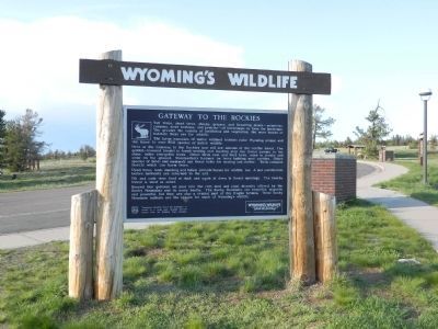
Welcome to wonderful Wyoming! As you travel through the state, your visit will be more enjoyable and interesting if you stay alert to one of Wyoming’s most precious treasurers—an abundance and diversity of free ranging wildlife. The wildlife . . . — — Map (db m94224) HM
Over this trail from distant Texas, passed the greatest migration of men and cattle in the history of America.
In Memory
of the pioneer cattlemen who passed this way on the Old Texas Trail 1866 to 1897. This plaque placed by the . . . — — Map (db m68054) HM
Fossil Butte is a 50 million year old lakebed and one of the richest fossil resources in the world. It is part of the Green River Formation, a layer of rock composed of laminated limestone, mudstone, and volcanic ash. Complete paleo-ecosystems are . . . — — Map (db m36624) HM
Often termed the star of all valleys, the Shoshone Indians referred to the valley as a "heap fine hunting ground." Unusually high precipitation and topographic features make the Salt River Valley one of the most productive and diverse of all . . . — — Map (db m84594) HM
Of all our magnificent big game animals, only the pronghorn antelope cannot be traced back to Eurasia. Other big game animals are believed to have migrated to the continent via the now sunken Bering land mass located between Siberia and Alaska. . . . — — Map (db m95479) HM
It is not coincidence that Wyoming supports over two-thirds of the world’s population of pronghorn antelope and sage grouse. The only vast expanses of sagebrush-grassland habitat left on the North American continent are found in Wyoming, Nevada . . . — — Map (db m88983) HM
From Wyoming's very beginnings and with the completion of the first transcontinental railroad, the livestock industry was anticipated to secure a viable ecumenic base for the new territory. Most of the territory consisted of rangeland where buffalo . . . — — Map (db m164522) HM
Along this trail passed herds of cattle from distant Texas to replace in Wyoming and Montana the fast vanishing buffalo and build civilization on the northwestern plains — — Map (db m98285) HM
Young Buffalo Bill Cody started his famous career with the great freighting firm of Russell, Majors and Waddell as a messenger boy. He became a spectacular Pony Express rider with the same firm and road between Red Buttes and Three Crossings, along . . . — — Map (db m91008) HM
Before the Army arrived in Yellowstone, the park's future was in doubt. Vandals destroyed thermal features, squatters sawed down trees and poachers decimated herds of wildlife. Perhaps the Army's greatest contribution to Yellowstone's history was . . . — — Map (db m123157) HM
Less conspicuous than the pronghorn antelope and the golden eagle is an even more ancient inhabitant of the high plains and valleys of Wyoming, the prairie rattlesnake. Feared by many and respected by most, these pit vipers (so-called because of . . . — — Map (db m88972) HM
The Buffalo Bill Scenic Byway stretches 27.5 miles from the Shoshone National Forest boundary to Yellowstone National Park. Originally built in 1901, the byway spans the North Fork of the Shoshone River Valley and divides two vast wilderness areas: . . . — — Map (db m89038) HM
About 3,000 years ago, small groups of people camped here for a short time. In 1985, archaeologists found stone tools and thousands of bone fragments associated with two fire hearths. The excavation revealed that in winter, the people subsisted . . . — — Map (db m228459) HM
This "living room floor" of the Pagoda Creek archaeological site was perfectly preserved. More than 4,000 artifacts of chipped stone flakes, tools, and bone fragments were found where they had lain for nearly 3,000 years. The site was buried when . . . — — Map (db m228585) HM
Yellowstone’s vast northern range is home to an amazing array of mammals. This wildlife community is one of the largest and most diverse of any on Earth! While visiting Yellowstone, you may see some of these animals. Remember, they are wild and . . . — — Map (db m88938) HM
After the ice sheet on Yellowstone Lake breaks up in May and grinds downstream beneath Fishing Bridge, you can witness a spawning frenzy. Cutthroat trout lay millions of eggs in the riverbed gravel within sight of the bridge. Spawning season has a . . . — — Map (db m88135) HM
As the days grow short and temperatures dip, bull elk feel the nudge of autumn. Instinct and experience guide them. Ready to compete, bulls pierce the air with bugling – their distinctive mating calls. Gathering and Guarding a Harem . . . — — Map (db m88847) HM
The American bison (Bison bison) symbolizes the spirit of the West. Few other animals inspire such awe and reverence. Hayden Valley, with its broad expanse of grasses and sedges, has been a home to bison for thousands of years. Nearly driven . . . — — Map (db m88482) HM
Lodgepole pines thrive in Yellowstone’s harsh climate and thin volcanic soils. These hardy trees cover much of the park and depend on fire to help spread their seeds. Because fire are common in lodgepole forests, Yellowstone residents have learned . . . — — Map (db m88862) HM
In June and July these rapids fill with cutthroat trout heading upstream to spawn near the lake outlet. Spawning is a life-and-death event; here at LeHardy Rapids you can witness the fierce energy it takes for the species to survive. Watch pools at . . . — — Map (db m88346) HM
At first glance, geyser basins may appear to be stark and lifeless places. Amazingly, they team with both microscopic and visible life year-round. Even the hottest thermal features contain tiny microbes that can live in one of earth’s most extreme . . . — — Map (db m88342) HM
Can you imagine living in a geyser? Thermophiles – microorganisms that thrive in heat –are perfectly adapted to living in geysers and their runoff channels. Some live where temperatures are hottest, while others reside in cooler areas. . . . — — Map (db m88434) HM
Bison seem lazy and docile grazing in the sun. They are massive and look as if they can hardly move. Do not be fooled. They are wild animals. They can spring to their feet in an instant if they feel threatened. They can leap over fences and run 35 . . . — — Map (db m88859) HM
Twelve miles east, the waters of the Gibbon and Firehole Rivers join to form the Madison River. Flowing through the heart of this valley, rich waters nourish an abundance of wildlife. Trout eat their fill from bountiful insect hatches. Using keen . . . — — Map (db m88863) HM
Upon its establishment in 1872, approximately 48 percent of Yellowstone’s waters were fishless. This did not go unnoticed. Stocking the park’s waters for anglers became a priority. The result? Over 310 million native and nonnative fish – some . . . — — Map (db m88393) HM
Grunts, rumbles, and roars vibrate the air. The summer day sizzles with energy as hundreds of bison mill restlessly. It seems chaotic, but there is a reason for the agitation. One of nature’s most spectacular reproduction rituals is in motion. . . . — — Map (db m88849) HM
A Time of Renewal Northern range wildlife grow strong in spring after a long, cold winter. Melting snow and rain turn the landscape green and lush. Bears emerge hungry from their winter dens, eager to feed on roots and grasses, . . . — — Map (db m88915) HM
For months on end their food is buried. Herbivores – plant-eaters – face the same relentless winter fate: adapt or starve. To reach sedges and dry grass, bison swing their huge heads back and forth, clearing away the drifts. Fields . . . — — Map (db m89124) HM
From an elk's perspective, this valley offers
everything needed for year-round survival.
Food is abundant. These meadows become
snow-free relatively early and stay lush longer
into summer. During May-June calving season,
nearby lodgepole . . . — — Map (db m46262) HM
Gray wolves (Canis lupus) are the largest member of the canine family. They are well suited to Yellowstone where winters are long and severe. Wolves move easily over the snow on their large paws, their thick fur keeping them warm. Wolves . . . — — Map (db m88906) HM
The Laramie Mountains provide a striking contrast for those traveling through the primarily flat to rolling prairies of southeastern Wyoming. Mountains are important to wildlife in Wyoming. As you go up in elevation, the average annual . . . — — Map (db m89160) HM
The abundance of Rocky Mountain bighorn sheep led the Indians to name this mountain range after these majestic animals. The Big Horn Mountains are a wildlife viewing paradise. Several native Indian tribes competed with each other and later with . . . — — Map (db m89010) HM
Livestock outnumbered emigrants five to one on the Lander Trail. A typical emigrant wagon needed four mules or 4-6 oxen to pull a wagon with up to 2,000 pounds of supplies. Emigrants also brought riding horses, milk cows, beef cattle, and even . . . — — Map (db m100366) HM
Dominated by sagebrush grasslands, the "high cold desert" provides habitat for one of the largest pronghorn antelope herds in the world. This region is home to 40,000 to 60,000 antelope, known as the Sublette Herd. The pronghorn has keen eyesight . . . — — Map (db m85809) HM
During construction of Highway 191 in the early 1990s, the oldest known pronghorn kill processing site in Wyoming was discovered and excavated on the ridges below. Three intact cultural layers were uncovered with radiocarbon dates ranging from 4690 . . . — — Map (db m180303) HM
Duck Creek riparian community is a diverse and complex society of living organisms. Wild brown trout feed on caddisfly nymphs, which live in self-made stick and stone shelters, clinging to the rocks. Yellow warblers and flycatchers next in willow . . . — — Map (db m47080) HM
Antler arches have been gates to the Jackson Town Square since 1960. The antlers are from elk that winter on the National Elk Refuge. About 7,500 elk spend each winter on the refuge. The bulls shed their antlers each spring. Antlers are picked up by . . . — — Map (db m47070) HM
In the high country, deep November snows cause elk to migrate to their winter range on the National Elk Refuge. In strings of 200 or more, thousands of elk arrive, some traveling more than 65 miles from southern Yellowstone National Park and . . . — — Map (db m88201) HM
This marsh area is the nesting and year-round home of the rare trumpeter swan. In winter months as many as 60-90 trumpeter and tundra swans find a haven on the National Elk Refuge because warm springs provide some ice-free open waters.By the early . . . — — Map (db m46371) HM
The Jackson Hole elk herd, numbering about 11,000 animals, is one of the outstanding natural resources of this country. Approximately 7,500 of the elk winter on the 24,300-acre National Elk Refuge, which is administered by the U.S. Fish and . . . — — Map (db m88154) HM
Moose thrive in wetlands abundant with willow, marsh grasses, and aquatic plants. Solitary by nature, some moose stay in this habitat year-round. Others migrate seasonally, traveling into mountain canyons to feed on summer vegetation and return to . . . — — Map (db m88297) HM
Named after Major T.T. Thornburgh who was killed in a fight with Ute Indians near White River Agency, September 29, 1879. The dog was a survivor of a wagon train burned during the battle and grew up as a military camp follower. Eventually he . . . — — Map (db m90637) HM
As a pup, Thornburgh was found by soldiers and named in honor of Major T.T. Thornburgh who was killed by Indians in 1879. The dog earned himself a place of respect over the years and is credited with several heroic deed. They include the capture . . . — — Map (db m90636) HM
You are standing at the bottom of Ten Sleep Canyon near the western edge of the Big Horn Mountains. These steep rocky cliffs were the native territory of the Bighorn sheep. Disease and the activities of humans and livestock have led to their . . . — — Map (db m97885) HM
Following the Civil War, construction of the transcontinental Railroad opened the West, ensuring elimination of vast buffalo herds and forcing Native American Indians onto reservations where the military provided food.
Leggy Texas Longhorns were . . . — — Map (db m98249) HM
Following the Civil War, construction of the transcontinental Railroad opened the west, ensuring elimination of the buffalo herds, forcing Native American Indians onto reservations where the military provided food. The rails transported range . . . — — Map (db m98248) HM