Lewis and Clark
The Lewis and Clark Expedition, officially the Corps of Discovery, was in what is now South Dakota from August 21 to October 14, 1804 and from August 21 to September 4, 1806.
While here they would make numerous . . . — — Map (db m213911) HM
From this vantage point, you can see the land formations described by explorer Joseph N. Nicollet and John Fremont when they camped at Oakwood Lakes in 1838. In Nicollet's words, "Wood is less scarce here. It is on all the tongues of land which . . . — — Map (db m237248) HM
Dedicated July 7, 1974 by Governor Richard F. Kneip
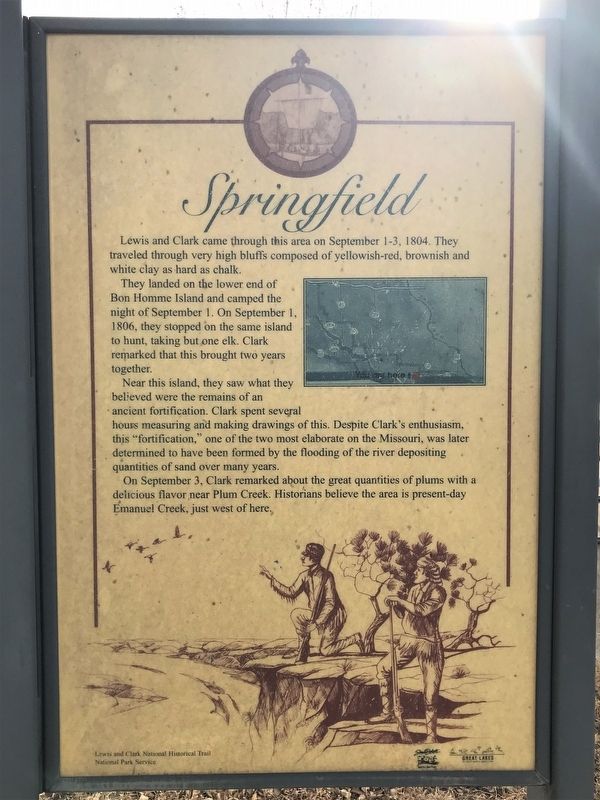
Meriwether Lewis and William Clark with their party camped at several points
near this crossing. In September 1804, continuous rain had soaked their gear.
They stopped near Ocoma, above . . . — — Map (db m180987) HM
This Corps of Discovery II marker commemorates the bicentennial
of the Lewis and Clark expedition.
The geographic position of this marker has been established
using the satellite-based Global Positioning System.
This marker is part of the . . . — — Map (db m101382) HM
When the Corps of Discovery reached present-day Chamberlain on September 16, 1804, they were ready for a break. Since May, one member of the expedition, Sergeant Charles Floyd, had died, possibly of appendicitis. Another, Private George Shannon, . . . — — Map (db m98240) HM
This spot offers a spectacular view of the Missouri River, but the river is much different today from when Lewis and Clark traveled up it. Several huge dams now control its flow.
When the expedition came through, the river could go from a mere . . . — — Map (db m242480) HM
Most of the native plants you see here are direct descendants of those found by Lewis and Clark when they arrived in the fall of 1804. As they traveled, the captains always noted stands of timber because they needed wood for kindling and because . . . — — Map (db m242479) HM
From this location you are able to view the “Beautiful Forks” of the Redwater River as it runs into the Belle Fourche River as named by French explorers as they passed through the area over 200 years ago. Of course, “Belle Fourche” (pronounced . . . — — Map (db m234799) HM
Lewis and Clark and the Legend of Stone Idol Creek
On their epic exploratory expedition Meriwether Lewis and William Clark stopped near here and noted two stones resembling human figures, and third like a dog. Capt. Clark writes on Oct. . . . — — Map (db m112085) HM
Lewis and Clark
The Lewis and Clark Expedition, officially the Corps of Discovery, was in what is now South Dakota from August 21 to October 14, 1804 and from August 21 to September 4, 1806.
While here they would make numerous . . . — — Map (db m187079) HM
Pickstown
Lewis and Clark passed this site on September 8, 1804. The next day they had their first encounter with prairie dogs, which they called barking squirrels. They killed one and caught one alive by pouring a great quantity of water . . . — — Map (db m187535) HM
The Omaha and Ponca
The Omaha and Ponca tribes were once a single people closely related to the Osage, Kansa and Quapaw tribes of the lower Missouri and Mississippi River valleys. The ancestoral Omaha-Ponca people migrated from that region . . . — — Map (db m234981) HM
The Missouri River flowed beneath the bluff when Meriwether Lewis and William Clark led the Corps of Discovery on their epic journey. The mouth of the White Stone River was then near this site at Cotton Park. Now known as the Vermillion River, its . . . — — Map (db m179205) HM
Lewis and Clark
The Lewis and Clark Expedition, officially the Corps of Discovery, was in what is now South Dakota from August 21 to October 14, 1804 and from August 21 to September 4, 1806.
While here they would make numerous . . . — — Map (db m187536) HM
On the hot day of August 25, 1804, captains Lewis and Clark and several of their men walked from the river to explore Spirit Mound. They had heard that little people with deadly arrows inhabited the mound. Although they did not find little people, . . . — — Map (db m194633) HM
The Missouri National Recreational River preserves two splendid segments of the free-flowing, once unpredictable "Big Muddy." These natural-appearing reaches are reminiscent of the river as reported in the journal pages of captains Lewis and Clark . . . — — Map (db m194634) HM
This trail leads to the summit of Spirit Mound, a sacred site for several Plains Indian tribes. Some tribal members make pilgrimages to Spirit Mound, say prayers on top, and leave offerings. As you approach and walk to the top, please do so . . . — — Map (db m39700) HM
Vermillion
August 24, 1804, Lewis & Clark camped near the White Stone (Vermillion) River and next day visited Spirit Mound 8 miles north. The military road, Sioux City - Ft. Randall after 1855 provided access, as did steamboats. A. C. Van Meter . . . — — Map (db m179392) HM
Lat 42° 46' 23.0" N
Long 96° 55' 51.0" W
From here the Water Trail follows five miles of the Vermillion River to its confluence with the Missouri River near River Mile 772, then continues down the Missouri nine miles to . . . — — Map (db m221312) HM
When William Clark climbed this "conical hill" in 1804, he concluded, correctly, that it was a natural form, not a human-created mound. Its central core is a bedrock of Niobrara chalk that the continental ice sheet did not erode away. The . . . — — Map (db m222056) HM
On August 25, 1804, several members of the Lewis and Clark Expedition left the river "to visit a High Hill...Supposed to be a place of Deavels...with remarkable large heads...[that] kill all persons who...attemp to approach the . . . — — Map (db m222050) HM
This spot was visited in 1804
by members of the Lewis and Clark Expedition
Placed by Paha Wakan Chapter
Daughters of the American Revolution
1921
Restored by the National Park Service, 2003 — — Map (db m242484) HM
When Jedediah was 23 years of age he went to St. Louis and enlisted with General William H. Ashley as an employee of the Rocky Mountain Fur co. In 1823 he was with Ashley and a party of 90 trappers, traders, and boatmen when they were attacked by . . . — — Map (db m179958) HM
Sakakawea won her place in history as the indomitable guide of Lewis and Clark on their trip to the Pacific in 1805. She was a member of the Shoshoni tribe dwelling near the Big Horn mountains in Montana. In one of the frequent tribal conflicts she . . . — — Map (db m190173) HM
First white man in the Black Hills, this courageous and brawny beaver trapper in 1823 led a dozen Mountain Men from Fort Kiowa to the Yellowstone. His party entered the Black Hills via the old bison trail through Buffalo Gap near here.
Born in . . . — — Map (db m89396) HM
Cultural conflicts erupted across the western Great Plains during the 1860s. Expanding railroads and frontier posts located in traditional hunting grounds impacted the various tribes in the northern plains. Restrictions on westward settlement . . . — — Map (db m121397) HM
An economic crash in 1873 affected the entire nation. The government, pressured to boost the economy, needed to explore new land. Open land for settlement and rich resources would create markets and new jobs.
George A. Custer and his . . . — — Map (db m121398) HM
This picturesque valley was the site of the permanent camp of the Black Hills Expedition of 1874 under the command of General George A. Custer of the 7th Cavalry. Their 5 day stay was the longest stop made during the entire expedition and General . . . — — Map (db m180983) HM
In 1874, George Armstrong Custer led a force of more than 1,000 men on an expedition to the Black Hills to explore and map this little-known area. The photographer with Custer, William H. Illingworth, was the first to take glass-plate photographs in . . . — — Map (db m155656) HM
Spurred by rumors of gold, many prospector groups attempted to enter the Black Hills in the 1870s. Without regard to the Fort Laramie Treaty, they planned to enter the region and exploit the untapped wealth.
A group of 28 people headed west from . . . — — Map (db m121399) HM
Benefit You The landscape before you has been logged several times since the early 1900's. Besides the obvious benefits of timber for building many products, timber harvesting benefits the forest community. Benefit . . . — — Map (db m234599) HM
Lat 43° 3' 15" N
Long 98° 33' 21" W
You are just downriver from Ft. Randall Dam, the first dam in South Dakota completed under the Pick-Sloan Plan by the US Army Corps of Engineers in 1956.
The Missouri River remains . . . — — Map (db m235011) HM
The landscape before you has undergone many changes since 1804. The Army's Corps of Discovery, headed by Captains Meriwether Lewis and William Clark, passed through here heading west. The hill you are standing on is man-made, associated with . . . — — Map (db m112893) HM
Lewis and Clark's stay in this area has been described as a "tense three days." The days with the Teton Sioux were filled with long periods of friendly visiting and good company but were also punctuated by isolated moments of trouble and . . . — — Map (db m223796) HM
The expedition passed Régis Loisel's abandoned trading post east of here on Sept. 22, 1804. Around the cedar fort, they saw Indian "lodges" and fallen cottonwoods, a sign that horses had been feeding on the bark. The next day, three Teton Sioux boys . . . — — Map (db m224669) HM
Welcome to Griffin Park! Griffin Park is located next to the Great Missouri, on which Meriwether Lewis and William Clark traveled during their Journey to the Pacific Ocean. Lewis and Clark's travels through this area have been considered as one of . . . — — Map (db m124870) HM
The Lewis and Clark Expedition, officially the Corps of Discovery, was in what is now South Dakota from August 21 to October 14, 1804 and from August 21 to September 4, 1806.
While here they would make numerous discoveries of animals, plants, . . . — — Map (db m124871) HM
Lewis and Clark and their men then spent September 21-29, 1804, in this area. Private John Colter camped and hunted on what is known today as Farm Island. Captain Clark dubbed La Framboise Island "Good Humored Island" as he and Captain Lewis were . . . — — Map (db m123914) HM
In 1804-06, Captains Meriwether Lewis and William Clark lead about 40 soldiers and boatmen on an epic journey. President Thomas Jefferson commissioned this "Corps of Discovery" to find a rout to the Pacific Ocean through the newly acquired . . . — — Map (db m112890) HM
The partnership of Registre Loisel and Hugh Heney in 1802 set up a fur post on Cedar Island, within sight, about 5 miles down stream. Loisel was called Little Beaver by the Indians. This was part of Louisiana, receded by Spain to France in 1800 and . . . — — Map (db m219925) HM
Who the first prospector was -
and when and where gold was
discovered in Deadwood Gulch
is open to question. It is generally
agreed that the Frank Bryant
party found the gold in August
1875 on Whitewood Creek,
probably 100 yards . . . — — Map (db m183191) HM
Gold was first discovered in the Black Hills by General George Custer's expedition in 1874. Or was it? There is some evidence that gold was actually discovered in the northern Black Hills in 1834 by a group of seven men who came here in 1833 . . . — — Map (db m184293) HM
Frontcame to these hills in 1833 seven of us
De Lacompt
Ezra Kind
G W Wood
T Brown
R Kent
Wm King
Indian Crow
all ded but me Ezra Kind
Killed by Ind beyond the high hill got our gold June 1834
got all of the . . . — — Map (db m184176) HM
White River has been so called since Perrin de Lac camped near mouth and met Cheyennes in 1802. 16 Sept. 1804 Sgt. Patrick Gass and Reuben Fields reconnoitering were at this point. — — Map (db m184643) HM
The trail blazers
here on December 26, 1875
Ben Ash, S.C. Dodge,
Russ Marsh, Ed Donahue,
and Stimmy Stimson
on their trip from Bismarck
through the Indian country
first sighted the Black Hills. — — Map (db m185222) HM
Sioux Falls took its name from these falls which are located in the Big Sioux River. Surrounded by a sea of grass, the falls were a remarkable discovery for explorers. For the land speculators that followed the explorers, these falls provided an . . . — — Map (db m127423) HM
This altar to courage was erected August 1, 1923 by the Neihart Club in honor of
Hugh Glass
who wounded and deserted here began to crawl to Fort Kiowa in the fall of 1823 — — Map (db m152993) HM
Across the reservoir, situated on an overlooking bluff, stands a monument to Hugh Glass, fabled pirate turned fur trader and frontiersman. In August of 1823, while on a fur trapping endeavor with the Ashley Fur Company, Glass was attacked by a . . . — — Map (db m152992) HM
Don't look now. Because that site is normally under 50 feet of
water. 125 feet from the shore at a point 1.15 miles northeast along a meandering shore line, from the point this road finally runs into the Oahe Reservoir. It was a landmark in . . . — — Map (db m184292) HM
The 1803 Louisiana Purchase expanded the United States westward. Meriwether Lewis and William Clark and The Corps of Discovery explored the nation's vast new territory on their 1804-1806 journeys. They found an abundance of beaver, buffalo, and . . . — — Map (db m124297) HM
The Lewis and Clark Expedition, officially the Corps of Discovery was in what is now South Dakota from August 21 to October 14, 1804 and from August 21 to September 4, 1806. While here they would make numerous discoveries of animals, plants, . . . — — Map (db m187080) HM
On September 25, 1804 The Corps of Discovery met under an awning near the mouth of the Teton (Bad) Raver with the Teton (Lakota) Sioux. A confrontation over the amount of gifts required to continue up river ensued, partially fostered by the lack of . . . — — Map (db m170479) HM
Near this spot on September 23-28, 1804, the historic first meeting of officials of the United States of America with the great Sioux Nation took place. President Thomas Jefferson commissioned Captains William Clark and Meriwether Lewis to explore . . . — — Map (db m124828) HM
In 1804-06, Captains Meriwether Lewis and William Clark led about 40 soldiers and boatmen on an epic journey. President Thomas Jefferson commissioned this “Corps of Discovery” to find a route to the Pacific Ocean through the newly . . . — — Map (db m170476) HM
Explorers Francois and Louis-Joseph Verendrye buried a lead plate here on March 30, 1743, claiming the region for France. The plate documents the Verendryes as the first European explorers on the northern plains. This site serves as proof of early . . . — — Map (db m124597) HM
Front
”In the twenty-sixth year of the reign
of Louis XV, the most illustrious Lord,
the Lord Marquis of Beauharnois being Viceroy,
1741, Pierre Gaultier de La Verendrye placed this.”
Back
Placed by the Chevalier . . . — — Map (db m124593) HM
In the 1700s, England, France, and Spain all worked hard to colonize North America. The French king gave Quebec fur trader, Pierre Gaultier de Varennes, Sieur de La Verendrye, authorization to expand France's hold in the new world. The French moved . . . — — Map (db m124591) HM
Verendrye Site
has been designated a
National Historic Landmark
This site possesses national significance
in commemorating the history of the
United States of America 1991
National Park Service
United States Department . . . — — Map (db m124595) HM
Here on March 30, 1743, the Verendryes buried a lead tablet to claim this region for France. This tablet found on Feb. 16, 1913, is the first written record of the visit of white men to South Dakota. — — Map (db m177391) HM
Beginning their journey on a diet of salt pork, lard with flour, and Indian meal (ground corn), Meriwether Lewis, William Clark, and the other members of the Corps of Discovery, went on to taste nearly everything the West had to offer - through . . . — — Map (db m100915) HM
Lewis & Clark camped here and said much ‘elk sign’ on August 22, 1804 and held first election in northwest that evening.
In 1856, the Sioux City-Ft. Randall Military Road passed hereby.
Eli Wixson arrived on 22 July 1859 and built a log . . . — — Map (db m180963) HM
The Missouri River Valley, up to this location, was well-known to French and British fur trappers. For decades, trappers navigated down the Big Sioux River and the lower Missouri toward St. Louis. Due to the intimidating presence of the Yankton . . . — — Map (db m100914) HM
Lewis & Clark reached a point in what is now Sioux City on August 20, 1804 near the mouth of Floyd River. Sergeant Charles Floyd, who had been taken sick with a "Biliose Chorlick" the day before, died near a bluff on the east side of the river. The . . . — — Map (db m190114) HM
Lewis & Clark Campsite
The Missouri River has carved many channels in its history. One such channel curved through the western edge of Elk Point creating the area now known as Heritage Park.
On August 22, 1804, Captain William Clark . . . — — Map (db m100821) HM
The Corps of Discovery returned to this location after a two-year absence on September 3, 1806. Meriwether Lewis and William Clark found their "Elk sign" campsite occupied by James Aird, a Scottish fur trader. They pressed him eagerly for news . . . — — Map (db m100912) HM
In 1804-06, Captains Meriwether Lewis and William Clark led about 40 soldiers and boatmen on an epic journey. President Thomas Jefferson commissioned this "Corps of Discovery" to find a route to the Pacific Ocean through the newly acquired . . . — — Map (db m100917) HM
While camped at the "Elk Sign" campsite on August 22, 1804, Captains Meriwether Lewis and William Clark acted to replace Sergeant Charles Floyd, who had taken ill and died two days earlier. They called for the Corps of Discovery to vote on . . . — — Map (db m100916) HM
One of the most notable women in American History may well be Sakakawea. A Shoshoni Indian girl named Sakakawea, acted as an interpreter while traveling with the Corps of Discovery on their way to and from the Pacific Ocean. As the Corps headed . . . — — Map (db m112141) HM
Near present-day Mobridge, South Dakota, Captain William Clark wrote in his journal that he saw "White bear" tracks. These tracks, which are "…3 times as large as a mans track…" were actually from a grizzly bear.
During the entire . . . — — Map (db m112150) HM
Captain William Clark enlisted his slave, York, as one of the members of the Corps of Discovery. York grew up in Virginia with Clark and traveled with the party during the entire journey to the Pacific Ocean and back to St. Louis, Missouri.
. . . — — Map (db m112155) HM
A bit of history lies under the water behind Oahe Dam. Before the dam was built many islands and sandbars were commonly found along the Missouri River. When the Corps of Discovery traveled along this river on the way to the Pacific Ocean they . . . — — Map (db m112088) HM
Here on October 9-12, 1804 Lewis & Clark counseled and sojourned with the Aricara Indians and were again here on their return from the Pacific on August 21-22, 1806. — — Map (db m112106) HM
By the 1500s, the descendants of the Skiri Pawnee People, the Arikara (or Ree) Indians, inhabited this area. Twelve village bands lived along the Missouri River in present-day South Dakota. Three of the villages were near the mouth of the . . . — — Map (db m112108) HM
In 1804-06, Captains Meriwether Lewis and William Clark led about 40 soldiers and boatmen on an epic journey. President Thomas Jefferson commissioned this "Corps of Discovery' to find a route to the Pacific Ocean through the newly acquired . . . — — Map (db m112122) HM
Lewis and Clark
The Lewis a nd Clark Expedition, officially the Corps of Discovery, was in what is now South Dakota from August 21 to October 14, 1804 and from August 21 to September 4, 1806.
While here they would make numerous . . . — — Map (db m112145) HM
This wide, low moving, Missouri River of today is quite different from when the Corps of Discovery navigated in then torrent waters in 1804. Lewis and Clark fought against the strong current, using ropes to pull the boat upstream. By the time . . . — — Map (db m112114) HM
In 1804-1806, Captains Meriwether Lewis and William Clark led
the Corps of Discovery on an epic journey. Charged by President
Thomas Jefferson to find a water route to the Pacific Ocean through
the newly acquired Louisiana territory, they mapped . . . — — Map (db m191294) HM