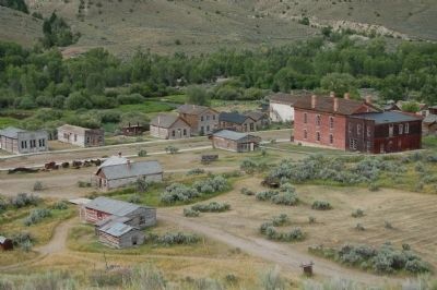
The Nez Perce camped near here on Horse Prairie Creek, Aug. 12 1877 following the Battle of the Big Hole Aug. 9-10. General Howard was summoned when beating drums arroused [sic] the citizens of Bannack. Women and children were quartered in the Meade . . . — — Map (db m49537) HM
Pursued by the U.S. Army since June 1877, approximately 800 Nez Perce (nimi•pu•) men, women, and children traveled over the Bitterroot Mountains and camped here in the Big Hole Valley. Thinking there was no immediate pursuit by the Army, this . . . — — Map (db m123743) HM
From this vantage point you can visualize the general progress of the Battle of the Big Hole, but at a distance from the fear and chaos of its hand-to-hand combat. The landscape has changed little since the morning of August 9, 1877. This lush . . . — — Map (db m123741) HM
(Inscriptions are found on three sides of this monument.)
On This Field
17 officers and 133 enlisted men of
the 7th U.S. Infantry
under its Colonel
Bvt. Major General John Gibbon with 8 other
soldiers and 36 citizens . . . — — Map (db m123812) WM
To the
everlasting
Memory of the
Brave Warriors of
Chief Joseph's Band
who fought on
these grounds
in the
Nez Perce War
of 1877
In Memory of
the Indians, Infants,
Children, Women
and Old Men
who . . . — — Map (db m123755) HM
(Three panels make up this informational marker:)
Natural Travel Corridor
Clark's 1806 Route
Captain Clark and his party found great quantities of camas just beginning to bloom when they passed here on Sunday July 6, 1806. . . . — — Map (db m123738) HM
In front of you on the morning of August 9, 1877, you would have seen soldiers and Montana volunteers pass by as they began to deploy for the coming attack on the Nez Perce encampment just through the trees.
Following the army's surprise attack, . . . — — Map (db m123745) HM
"In grateful recognition of the valor and sacrifice of the soldiers killed in action fought on these grounds, between the United States Forces under General George Crook and Sioux and Cheyenne Indians under Chief Crazy Horse. June 17, 1876. 3rd U.S. . . . — — Map (db m221578) HM WM
On August 10, 1983 a prairie fire swept over the battlefield, burning nearly 600 acres of dense, thick vegetation. In May and June of 1984 the National Park Service began an unprecedented systematic archeological survey of the Custer Battlefield. . . . — — Map (db m86810) HM
In memory of enlisted men 2nd and 7th U. S. Cavalry and 5th U. S, Infantry killed in action near Bear Paw, Montana September 30, 1877 < Left Side of Monument : > 7th U. S. Cavalry Troop A 1st Serg’t Geo. McDermott Serg’t Otto Derglew . . . — — Map (db m86873) HM
This monument was originally erected at Ft. Keogh in 1881 to honor U.S. Army casualties from the 1877 Nez Perce War. PLEASE NOTE: “Hostile Indians” is in historical context with a term used for Native American enemies of the United . . . — — Map (db m86865) HM
This position was held by Co. L commanded by Lt. James Calhoun. It may have been used to hold off Chief Gall and his Sioux warriors and thus protect Custer's advance. From here these soldiers could have attracted Capt. Benteen's column and the pack . . . — — Map (db m21643) HM
After separate skirmishing, Custer’s command reunites here. Company L, under Lt. James Calhoun, skirmishes with Gall, Crow King, Two Moons, and other warriors. From here these soldiers could have attracted Capt. Benteen’s column and the pack . . . — — Map (db m86838) HM
After the battle, Sioux and Cheyenne removed their dead and buried them in tipis, scaffolds, and adjacent hillsides in the Little Bighorn valley. Southern Cheyenne Chief “Ve’ho’enohnenehe” (Lame White Man) and Northern Cheyenne . . . — — Map (db m86860) HM
The white markers on the knolls and in the ravines to the west and southwest show were the troopers of Co, C under Capt. Tom Custer and Co. E under Lt. Smith were found. The Indian encampment lay beyond on the flat across the river. — — Map (db m21645) HM
From this promontory 13 miles away in the Wolf Mountains, Custer's scouts observe the Lakota, and Cheyenne pony herd and evidence of a large village in the valley behind you. Convinced the Indians had spotted his regiment and would soon scatter, . . . — — Map (db m45580) HM
From the Crow’s Nest, a vantage point 14 miles away in the Wolf Mountains, Custer’s Crow and Arikara scouts saw evidence of the massive Lakota, Cheyenne, and Arapaho encampment. Convinced that he was discovered, Custer abandoned plans for a . . . — — Map (db m86817) HM
After the brief encounter near the river, Custer’s two companies retreat up the ravine to your right known as Deep Coulee. The remainder of Custer’s command skirmishes with warriors on the high ridge ½ mile to your right. Seizing the . . . — — Map (db m86831) HM
Deep Ravine (Crazy Horse Gully & Grey Horse Ravine) was the scene of fierce fighting during the battle. Crazy Horse, and other Sioux and Cheyenne warriors crossed the Little Bighorn River (in front of you) and rode up the ravine during the attack . . . — — Map (db m86800) HM
Custer’s command deploys in the current national cemetery area and advances into the basin across the road to your left before withdrawing to Last Stand Hill. Toward the conclusion of the battle, soldiers from Company E moved toward the Deep . . . — — Map (db m86839) HM
Warriors ascend the large ravine behind you pursuing Custer’s troops. Soldiers retreat through the area to your front and right. Indians position themselves along the ridge to your left knows as Greasy Grass Ridge. Archeologists discovered numerous . . . — — Map (db m86834) HM
On June 25, 1876, approximately 7,000 Lakota, Cheyenne, and Arapaho, including 1,500 – 2,000 warriors, encamped below on the Greasy Grass River (Little Bighorn). Under the political and spiritual leadership of Tatanka-Iyotanka (Sitting Bull), . . . — — Map (db m86814) HM
An Indian memorial to honor Native American participation in the Battle of the Little Bighorn, June 25-26, 1876, and change the name of Custer Battlefield National Monument to Little Bighorn National Monument, was authorized by Congress in 1991 . . . — — Map (db m86804) HM
The Indian charge shatters the Calhoun defense and crashes through the soldier position at right, held by Capt. Myles Keogh’s Company I, Crazy Horse and White Bull cut down the retreating soldiers who flee northwest along this ridge in an effort to . . . — — Map (db m86811) HM
This knoll was contested by Indians and soldiers. Some evidence indicates soldiers of Company C occupied this position since bodies of Sergeants Finckle and Finley were found here. Indian testimony suggests that Southern Cheyenne war leader Lame . . . — — Map (db m86836) HM
Lakota, Cheyenne, and Arapaho warriors surrounded this position near the climax of the battle. Lt. Col. George Armstrong Custer and approximately 41 men, shoot their horses for breastworks and fight to the death. Custer and several soldiers were . . . — — Map (db m86801) HM
This area was occupied by troops A, B, D, G, H, K, and M, 7th. U.S. Cavalry, and the pack train when they were besieged by the Sioux Indians June 25th and 26th 1876. — — Map (db m21636) HM
(Bottom of Marker):
In memory of
Officers and soldiers who fell near this place
fighting with the 7th United States Cavalry
against the Sioux Indians
on the 25th and 26th of June,
A.D. 1876
(The rest of the marker includes . . . — — Map (db m7022) HM
Arikara “I shall not see you (sun) go down behind the mountains tonight . . .I am going home today, not the way we came, but in spirit, home to my people.”- Bloody Knife, Arikara (June 25, 1876) “These Old Scouts, . . . — — Map (db m87723) HM
Advancing down Reno Creek, Custer pauses at a tipi located behind this ridge. The tipi contains the remains of a Sans Arc warrior killed a week before at the Battle of the Rosebud. Indians flee toward the village, prompting Custer to order Reno's . . . — — Map (db m45581) HM
After leaving Cedar Coulee, Custer descends toward the Little Bighorn River in the ravine ahead known as Medicine Tail Coulee. Custer probably again divides his command: three companies likely ascend to the higher ridges beyond. Two companies . . . — — Map (db m86824) HM
As soldiers descend Medicine Tail Coulee, the Minniconjou and Cheyenne camps were on the western bank. Archeological evidence supports Indian testimony, that initial fighting took place on the flats near the river to your left and cutbank directly . . . — — Map (db m86827) HM
Following the battle, the Lakota and Cheyenne removed their dead and buried them in lodges, scaffolds, and the hillsides. Surviving members of the 7th Cavalry hastily buried the soldiers, Indian Scouts, and civilians on June 28, 1876. In 1877, . . . — — Map (db m86844) HM
Indian descendants of participants in the Battle of the Little Bighorn helped form the vision of the Indian Memorial. The “Peace Through Unity” theme was conceived by the late Enos Poor Bear, Sr. and Austin Two Moons. Together, they . . . — — Map (db m86806) HM
Under mounting pressure, Reno abandons the timber. His retreat disintegrates into a rout as pursuing warriors ride in amongst the troopers killing more than 30 soldiers. Indian casualties are few. Lakota and Cheyennes drive the cavalry across the . . . — — Map (db m86821) HM
After fording the Little Bighorn River one mile to your left, Reno’s battalion gallops down the valley below. Convinced he is vastly outnumbered, Reno dismounts, and forms a skirmish line across the valley floor, firing into the lodges. Warriors . . . — — Map (db m86819) HM
Reno's battalion of 175 soldiers, civilian personnel, and Arikara and Crow Scouts halt in the valley and form a thin skirmish line. Warriors race out from the village to oppose him. After 10 minutes of fighting Lakota and Cheyenne warriors outflank . . . — — Map (db m45583) HM
During Reno's retreat from the timber, Crazy Horse, Wooden Leg, Black Elk, and perhaps as many as 600 warriors chase the soldiers across the Little Bighorn River. Reno's casualties are 40 men killed and 13 wounded. The remnants of Reno's command . . . — — Map (db m45584) HM
After the battle, 39 cavalry horses that had been shot for breastworks during Custer’s Last Stand, were found among the dead on Last Stand Hill. In 1879, a temporary cordwood monument was erected by the Army on the crest of the hill. The area, . . . — — Map (db m45604) HM
June 25-26, 1876 - From the ridge to your right, Custer first views the village. Needing more information about the extent of the encampment, he moves further north. After witnessing the beginning of Reno's charge, Custer's five companies descend . . . — — Map (db m45587) HM
After an unsuccessful attack on the Indian camp in the valley, Major Reno and his battalion retreated to this vicinity where they were soon reinforced by Captain Benteen's battalion and the pack train. In an attempt to find and rejoin Custer they . . . — — Map (db m45554) HM
Reno occupies a defensive position in the timber. Determined to defend their village, warriors soon penetrate the woods, convincing Reno that the position is untenable. After fighting for 30 minutes, Reno retreats across the Little Bighorn River. — — Map (db m45585) HM
In an attempt to locate Custer, Company D under Captain Thomas Weir advances to this hilltop position without orders late on June 25. Weir may have witnessed the conclusion of the battle three miles ahead. He is later joined by Captain Benteen and . . . — — Map (db m86823) HM
This is the farthest point reached by Capt. Weir in his attempt to assist Custer. Minutes after arriving, his company was joined by Capt. Benteen's company and others. They remained about 45 minutes until mounting warrior pressure forced them back . . . — — Map (db m21640) HM
The hill in front of you was occupied by Lakota, and Cheyenne during the fight on Last Stand Hill. An unknown Sioux warrior wearing a warbonnet was killed here while firing his rifle at soldiers positioned behind a horse barricade on the crest of . . . — — Map (db m45593) HM
"They made us many promises, more than I can remember, but they never kept but one: they promised to take our land and they took it." - Chief Red Cloud, Oglala Sioux
Major Conflicts of the Plains Indian War
August 19, 1854 Gratten . . . — — Map (db m189765) HM
The words of those engaged in the Battle of the Rosebud, and the people still affected, tell a narrative of the conflict's significance.
Kase'eetsevo' estanevosehaesta'tanemo
(The Fight Where The Girl Saved Her Brother) . . . — — Map (db m224316) HM
Garryowen, the old Irish tune, was the regimental marching song of the 7th U.S. Cavalry, General Custer's command.
The Battle of the Little Big Horn commenced in the valley just east of here June 25, 1876, after Custer had . . . — — Map (db m67897) HM
Where the Battle of Little Big Horn Began
June 25, 1876
(map of battlefield)
(showing Custer’s column, Reno’s column, Indian camp, Last Stand Hill)
Custer Battlefield Museum — — Map (db m98277) HM WM
On this site in 1876 the historic Battle of the Little Big Horn began. “When we stand side by side in the circle of no beginning and no ending, the first maker, creator of all things, is in the center. He hears the words of supplication and . . . — — Map (db m86022) HM
Captain Edward Ball, leading two companies of the Second Cavalry from the Montana Column, was ordered to scout along the Bighorn as far south as the 1868 ruins of Fort C.F. Smith. The detachment was then to cross over the divide to the Little . . . — — Map (db m189447) HM
Captain Grant Marsh (1834-1916), one of the most skilled riverboat pilots on the Upper Missouri
during the steamboat era, figured prominently in both the events leading up to the Battle of the Little
Bighorn and its aftermath.
The steamboat . . . — — Map (db m189458) HM
Established as a military post November 1877 by order of President Rutherford B. Haynes and General Phil H. Sheridan. Garrisoned as one of the important Military posts in the Northwest until abandoned by the Government, September 1897. This Fort . . . — — Map (db m148124) HM
For the exhausted Nez Perce, this site, known to them as ćáynim?a•lika?spe (Place of Manure Fire), appeared to be a good place to rest before continuing to Canada. Then a large force of U.S. soldiers surprised them from the east. After . . . — — Map (db m142832) HM
C'Aynnim 'Alikinwaaspa is the Nez Perce name for this site. It means "Place of the Manure Fire" because the Nez Perce used buffalo chips as fuel here.
On September 29, 1877, about 700 Nez Perce men, women and children camped in the basin . . . — — Map (db m142830) HM
Two panels are affixed to a common boulder.
Commemorating the surrender of Chief Joseph and the remnants of his tribe of Nez Perce to General Nelson A. Miles, October 5, 1877.
Here Chiefs Looking Glass, Ollicut, Too-hul-sote and . . . — — Map (db m142802) HM WM
To the
everlasting
memory
of the
Brave Warriors
Chief Joseph's Band
who fought on
these grounds
in the
Nez Perce War
of 1877
Erected by
Nez Perce Indians
and the
Chief Joseph Memorial
Association . . . — — Map (db m142865) WM
With the fighting at a standoff, Hinmatóowyalahtq̓it (Chief Joseph) met with Colonel Miles near this site. Surrender was a survival strategy, to keep the Nez Perce people alive and together. One witness reported that Chief Joseph spoke . . . — — Map (db m142869) HM
These rolling hills and coulees are the site of the last battle of the 1877 Nez Perce War. For the Nez Perce this was the end of a 1,170-mile journey, after many successful skirmishes along the way. Canada was only 40 miles farther, its mountains . . . — — Map (db m142833) HM
About noon the families made camp. The scouts killed several buffalo. This place is ćáynim?a•lika?spe (Place of Manure Fire) .... Some warriors were on the buttes watching for enemies. We expected none. -- himi・n maqsmáqs . . . — — Map (db m142838) HM
This park links a series of widely separated sites of deep significance to the Nez Perce – historic villages, battlefields, and legend sites. The park experience involves a journey across both time and territory. Although firmly connected to . . . — — Map (db m142831) HM
The large depression is the site of a mass grave. Here the U.S. Army buried its casualties from the battle. This ridge is also the site of a hastily erected field hospital -- just a tent were surgeons tended and operated on the wounded. In 1912 the . . . — — Map (db m142868) HM
From where the sun now stands I will fight no more forever.
October 5 1877
Surrender of Chief Joseph to Colonel Nelson A Miles
To the valor and devotion of those both red and white who struggled here
Erected by the Congress of . . . — — Map (db m142801) HM
This battle was fought September 30 to October 5, 1877, on Snake Creek, about 20 miles south of here near the Bears Paw Mountains, where after five days days' siege Chief Joseph, one of five remaining Nez Perce leaders, surrendered to Col. Nelson A. . . . — — Map (db m142800) HM
Barring fur trading posts, the first important white settlements in Montana were the mining camps in the western mountains.
Everything to the east belonged to the plains Indians and was buffalo range.
To protect the miners and settlers from . . . — — Map (db m101871) HM
Gaze out over the lands around you and imagine them filled with 2,000 tidies and 15,000 Indians-it has happened at least twice. Here, enormous gatherings were called to negotiate treaties that transformed relations between Indian tribes and opened . . . — — Map (db m161905) HM
On September 21, 1877, Fort Benton commander Major Guido Ilges got word that the Nimíipuu (Nez Perce) had traveled across the Judith Basin headed for Canada. Thirteen members of Company F, Seventh Infantry Regiment and to civilians volunteers . . . — — Map (db m161479) HM
This three-inch ordinance rifle came to Fort Benton sometime after the Civil War, probably during the time it was a military port, 1869-1881. It has remained here since its arrival, and was here during the Indian Wars of 1876-1877. It has seen no . . . — — Map (db m168229) HM
Across the street is a log house that was occupied by Major Guido Ilges, commander of the troops at Fort Benton during the Indian Wars of 1876-1877. Ilges took a volunteer force of eighteen men to Cow Island where they confronted the Nez Perce . . . — — Map (db m161591) HM
In September 1877 the Nez Perce traveled across the Judith Basin headed for Canada. In anticipation of trouble, Major Ilges (commandant at Fort Benton) organized a party of fifty volunteers, mostly Fort Benton's Irish Fenians. They loaded the . . . — — Map (db m142215) HM
As envisioned, the City of Ophir was to rival Fort Benton. It was to have ferries across the Missouri River, warehouses, docks, wharves, wagon routes, and a few associated businesses. Construction began in 1865, Soon, 400 lots had been surveyed and . . . — — Map (db m161802) HM
Erected by J.H. Friend's Family Descendants of Franklin Friend
for the
Victims of Blood Indian Massacre May 25, 1865
Franklin Friend - George W. Friend
Abraham Lotts - John Alley
John Andrews - N.W. Burris
Frank Angeline - Henry . . . — — Map (db m142490) HM
Custer's first encounter with the Lakota occurred on August 4, 1873 near the confluence of themTongue River, At this time, the Seventh Cavalry was assigned to Colonel David Stanley's command to protect Northern Pacific railroad surveyors operating . . . — — Map (db m189166) HM
This is the river that exuberant parties claim is a mile wide, an inch deep, and runs up hill. The statement is exaggerated. Captain Clark, of the Lewis and Clark Expedition, named it the Redstone in 1806 and afterwards found out that the Indians . . . — — Map (db m155578) HM
Captain Wm. Clark and ten others camped near the mouth of the Tongue River on July 29, 1806. Clark noted the great number of buffalo in the area and reported that the river was so muddy and warm that it was "very disagreeable to drink." Clark . . . — — Map (db m163877) HM
Three panels make up this marker.
(panel 1:)
For thousands of years the fertile Wallowa Valley was home to many Nimiipuu, or Nez Perce people. A treaty in 1855 affirmed Nez Perce ownership of this homeland. Competition for . . . — — Map (db m143628) HM
Near this site, where the Missouri and Judith Rivers join together, the United States Army built the first military post in Montana Territory on July 10, 1866. The post, under the operation of the 13th Infantry, continued to provide service to the . . . — — Map (db m161910) HM
The Mansion was built in 1895 as the home of Mr. & Mrs. Charles E. Conrad. E.C. Conrad was a prominent Missouri River freighter, trader and pioneer during the Gold Rush and Indian Wars and later founded the city of Kalispell. The mansion has 23 . . . — — Map (db m160125) HM
Established as a military post August 27, 1867 by order of
President Andrew Johnson and General U.S. Grant
the post was abandoned in December 1886
Captain Wm. Clark
of the Lewis and Clark Expedition
encamped here July 14, 1806 with his . . . — — Map (db m98279) HM
The Early Days
Even before World War I, the expansive flat area that is now Cut Bank International Airport drew the attention of local "brave souls" who dared to fly early aircraft and land on a grass airstrip. When WWI ended in 1918, the . . . — — Map (db m220324) HM
The Nez Perce people, under the leadership of their Great Chief Joseph crossed the Musselshell River near here on September 17, 1877. They had left their Idaho homeland in a valiant but futile effort to reach Canada. Their march marked by several . . . — — Map (db m188961) HM
In July 1878, a band of Nez Perce Indians returning south from Canada after eluding U.S. Cavalry, crossed what is now Granite County. While passing through they attacked a small mining camp located on a tributary of Rock Creek at McKay Gulch. Three . . . — — Map (db m45211) HM
One-half mile west of here, a steep, narrow ravine runs north from Lolo Creek, In the early morning of the fourth day of standoff, the Nez Perce ascended the ridge next to this ravine. Using skills acquired by life in the mountains and plateaus of . . . — — Map (db m123241) HM
About twenty miles west of here at Lolo Hot Springs, the Nez Perce heard that soldiers were coming, so they moved cautiously and set up camp four miles from here.
Three parleys (meetings) between Nez Perce, soldiers, and citizens were held over . . . — — Map (db m123240) HM
During the Civil War, soldiers often fought out in the open causing thousands of casualties. Because of this, the military decided to formally instruct and equip soldiers to entrench themselves. Soldiers and citizens here fully embraced this new . . . — — Map (db m123239) HM
Established June 7 - 1877
By a Detachment of the Seventh Regiment U.S. Infantry during the Campaign against Chief Joseph and the Nez Perce Indians. — — Map (db m123258) HM
In Memory of
Sergeant Ernest Veuve, U.S. Army.
Recipient of the Medal of Honor for
Conspicuous Gallantry Beyond the Call
of Duty at Staked Plains, Texas, 1874. — — Map (db m144335) HM WM
For three months the members of the Nez Perce non-treaty bands had been constantly on the move evading the military. Scouts ranged in front and guarded behind the traveling village of mostly children, women and old people, as they sought safety and . . . — — Map (db m130230) HM
Fur trappers came upriver in the wake of the Lewis and Clark Expedition in 1806. These visitors left behind them tall tales of their adventures and a few trading posts scattered along the Yellowstone River. Southeastern Montana was Indian and . . . — — Map (db m189174) HM
For thousands of years before the arrival of Europeans, American Indians thrived in what is now the American West. Many tribes depended on bison (buffalo) for food, clothing, shelter, trade, and much more. When white settlers set their sights on . . . — — Map (db m210110) HM
One the morning of May 23, 1876, two cavalrymen and a citizen teamster, attached to Colonel John Gibbon's Montana Column, were ambushed by a war party of Lakota in the bluffs on the north side of the Yellowstone a few miles downriver from this . . . — — Map (db m164801) HM
135 entries matched your criteria. The first 100 are listed above. The final 35 ⊳