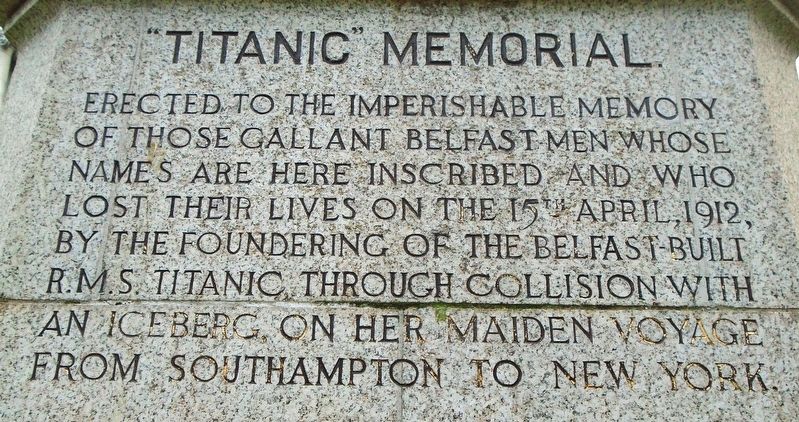
Erected to the imperishable memory
of those gallant Belfast men whose
names are here inscribed and who
lost their lives on the 15th April, 1912,
by the foundering of the Belfast built
R.M.S. Titanic, through collision . . . — — Map (db m134331) HM
In proud memory of
a true soldier
BIG BILL CAMPBELL
Died 8th January 1997
Lest We Forget
No.5 Platoon
———————————
No. 1 Platoon 'A' Company
L.P.W.W. Scotland
1st Belfast Battalion
In Everlasting Memory Of
VOLUNTEER ALASTAIR . . . — — Map (db m135141) WM
KEY
(1) (2) The illuminated blue lines demonstrate the actual size and location of the Titanic (1) and Olympic (2) ships constructed on these two Slipways.
(3) The turfed and decked areas denote the proportions of people that survived . . . — — Map (db m135002) HM
Titanic Memorial Garden is a permanent tribute to over 1,500 passengers and crew who died after the ship struck an iceberg and sank in the North Atlantic during its maiden voyage in April 1912.
When RMS Titanic departed Southampton on 10 . . . — — Map (db m134337) HM
[Front]
On 31 May 1911, SS 401, Titanic, slid down Slipway No. 3 at the Queen's Yard of Harland and Wolff and settled on the waters of the Victoria Channel in Belfast Lough. In her brief life she would be the largest, most luxurious vessel ever . . . — — Map (db m135088) HM
The Salmon
The natural life cycle of a salmon is one of nature's wonders. A salmon begins its life in the shallow water and gravel beds of the river as eggs then fry. These small fry stay in the river until they mature into par. The next . . . — — Map (db m70892) HM
Honouring the
bravery and sacrifice of
John Nichol
of Armagn Fire Station, who
gave his life in the line of duty
at Upper English St.
Armagh
27th August
1976 — — Map (db m210140) HM
[Side A]
On 12 August 1969, as the Apprentice Boys Parade passed the edge of the Bogside, nationalists clashed with parade followers and police. The police and loyalists followed the nationalists back into the Bogside, where defences had . . . — — Map (db m71441) HM
The Artists' first coloured mural is a tribute to the women of Derry and their role in the civil rights campaign. Bernadette Devlin, Britain's youngest MP, addresses the crowd during the Battle of the Bogside: her actions resulted in a six month . . . — — Map (db m71187) HM
It was here that James II demanded entry to the city during the 1689 siege. The present gate was built at the suggestion of Bishop Hervey in 1789 to celebrate the centenary of the siege. The head facing Bishop Street represents the river Boyne . . . — — Map (db m71021) HM
This mural depicts the events of 30th January 1972 when the British Army opened fire on a civil rights demonstration, killing 14 people. A local priest waves a bloodstained handkerchief at the soldiers as he leads a group of men, carry the body . . . — — Map (db m71215) HM WM
On 30 January 1972, a massive British military operation in Derry's Bogside ended in the murder of thirteen unarmed civil rights demonstrators and the wounding of fifteen others - one of whom died later of his injuries on 16 June 1972.
The . . . — — Map (db m71306) HM
On 30 January 1972 the ‘elite’ British Parachute Regiment opened fire on a peaceful civil rights march along this street, killing 14 unarmed marchers and wounding 14 more. The dead and wounded were labelled gunmen and bombers by a partisan . . . — — Map (db m71435) HM
Demolish the walls
The Maiden City withstood two sieges without its walls being breached. In the 18th century the city grew too big for its walls and increasingly houses and factories were built on the slopes below. Castle Gate (1803) was . . . — — Map (db m70960) HM
The city has always expressed its soul in verse.
Derry mine! My small oak grove
Little cell, my home, my love!
Attributed to St. Colmcille
The saint's story is told as St Columb in the Cathedral and as St Colmcille in Long Tower . . . — — Map (db m71005) HM
Roaring Meg
Roaring Meg is the most famous of the city's cannon. She weighs a mighty 1794 kilograms. The Fishmongers' Company of London presented her to the city in 1642. She saw action in the 1689 siege, probably from this bastion. It . . . — — Map (db m71007) HM
Locking the gates
In 1688 James II proposed to replace the Protestant garrison in the city with Catholic troops. Rumours were rife that the citizens were to be massacred. Meeting in the Diamond, the city leaders could not make up their . . . — — Map (db m71097) HM
This gate was built in 1865 on the site of one of the four original entrances to the city. Like Bishop's Gate it had a drawbridge, which could be pulled up in times of troubles, to allow people to cross the dry moat. This was the gate that the . . . — — Map (db m71104) HM
On 5 January 1969, after a night of rioting and sustained police attacks on the Bogside, the words "You Are Now Entering Free Derry" were painted on the gable wall of 33 Lecky Road. This simple graffiti became the defining symbol of the civil . . . — — Map (db m71204) HM
IRA. Vol. Bobby Sands,
Born 9th March 1954
Died 5th May 1981
Age: 27 (66 Days).
IRA. Vol. Francis Hughes,
Born 28th Feb 1956
Died 12th May 1981
Age: 25 (59 Days)
INLA. Vol. Patsy O'Hara,
Born 11th July 1957
Died 21st May . . . — — Map (db m71219) WM
Bulwarks and bastions
When first built, the bastions were known as bulwarks, each called after a person associated with the city from King James I to the Governor of the Plantation. They were renamed during the 1689 siege. This is . . . — — Map (db m70957) HM
This mural depicts one of the surviving hunger strikers as he looked after 53 days without food. He was one of seven men who went on hunger strike at the Maze prison in Belfast from 28th October, 1980 in protest against loss of their rights as . . . — — Map (db m71436) HM
Fire power
Magazine Gate takes its name from the Plantation city's gunpowder store. The mixture of saltpetre, sulphur and fine charcoal had to be kept very dry as it easily absorbed water. A barrel of gunpowder and a pile of shot was . . . — — Map (db m70956) HM
Free Derry ended at 4am on 30th July 1972 when thousands of British troops in tanks and armoured cars invaded the Bogside and Creggan 'no-go' areas. During Operation Motorman, they tore down the barricades with bulldozers. The Artists chose the . . . — — Map (db m71284) HM
The first shot
On 13th April, 1689 the first shot of the siege was fired. Citizens on the walls spotted the vanguard of the Jacobite army approaching under Lieutenant General Richard Hamilton. To make his presence known, Hamilton fired a . . . — — Map (db m71098) HM
The siege governors
The Royal Bastion is associated with the city's four governors during the 1689 siege. Professional soldier Robert Lundy was unconvinced that the city could be defended against Jacobite attack. His indecisiveness and . . . — — Map (db m70987) HM
This mural was painted to commemorate the 25th anniversary of Bloody Sunday. A circle frames the faces of the 14 victims with the youngest in the centre. The circle is the symbol of wholeness, the goal of the healing process. Fourteen oak . . . — — Map (db m71158) HM WM
For two days in August, 1969 local people resisted attempts by the Royal Ulster Constabulary to break down the barricades which they had erected to defend their community. The Battle of the Bogside ended when the British government sent in the . . . — — Map (db m71168) HM WM
If 'stones could speak', what a story they would have to tell. Their voices still echo on the walls and in the city streets.
According to tradition St. Colm Cille chose the oak grove on top of the hill for his monastery in 546 AD. His . . . — — Map (db m71026) HM
If 'stones could speak', what a story they would have to tell. Their voices still echo on the walls and in the city streets.
According to tradition St. Colm Cille chose the oak grove on top of the hill for his monastery in 546 AD. His . . . — — Map (db m71121) HM
This monument was erected to perpetuate the memory of the Rev. George Walker, who, aided by the garrison and brave inhabitants of this City, most gallantly defended it through a protracted siege, viz., from the 7th Dec. 1688 O.S. to the 12th . . . — — Map (db m70988) HM
Annette McGavigan
Aged 14
Shot dead by the British Army
6 September 1971
———————
Here the innocence of a child's world contrasts vividly with the chaotic violence with which others have surrounded her. The mural commemorates . . . — — Map (db m71155) HM WM
In 1836 the Poor Law Enquiry found that over one third of people in Ireland were dependent on the potato as their main source of food. The population had grown to 8.2 million by 1841, and was vulnerable to any failure of the potato crop. The . . . — — Map (db m72600) HM