[Center and Main Marker:]
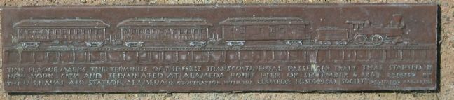
This plaque marks the terminus of the First Transcontinental Passenger train that started in New York City and terminated at Alameda Point Pier on September 6, 1869. Erected by the U.S. Naval Air . . . — — Map (db m150959) HM
City of Berkeley Landmark
designated in 1991
One of Berkeley’s romantic treasures, Orchard Lane is the formal pedestrian entrance to the Panoramic Hill residential neighborhood.
The walk and grand Classical staircase, complete with pillars, . . . — — Map (db m54692) HM
Berkeley History
The Panoramic Hill Historic District typifies Berkeley’s early hillside neighborhoods. Steep and narrow Panoramic Way, carved out in 1888, opened the hill to residential development. University professors and early Sierra Club . . . — — Map (db m54694) HM
City of Berkeley Landmark
designated in 1991
Rose Walk was designed by Bernard Maybeck and completed in 1913 with donations from the neighbors. The walkway linked the Euclid Avenue streetcar line with residences higher on the hill.
After . . . — — Map (db m53859) HM
City of Berkeley Landmark
designated in 2005
These entry gates help define one of Berkeley’s most gracious residential areas, Claremont Court, which was designed to attract the growing number of prosperous Bay Area professionals in the early . . . — — Map (db m54800) HM
On a once rural site now bordered by Russell Street, College Avenue, and Stuart Street, the Kelsey family planted orchards and grew ornamental plants on land they purchased in 1860. The 24-acre Kelsey Ranch supplied trees and plants for the grounds . . . — — Map (db m54691) HM
Mural designed by Osha Newmann, painted with O’Brien Thiele, Janet Kranzberg, Daniel Galvez and many others
Painted in 1976
Restored and enlarged in 1999
City of Berkeley Landmark
designated in 1990
The mural on this wall was painted . . . — — Map (db m54696) HM
This site was part of the original Don Castro Land Grant. In 1866 pioneer settler Josiah Grover Brickell made a land grant of this site for “educational purposes only” and paid the teacher’s salary, who taught children by day, in a one . . . — — Map (db m100557) HM
William born in Kilkenny, Ireland, 1845. Ellen Fallon Tehan, daughter of Ellen and Jeremiah Fallon, was a year old when she came west by covered wagon from St. Joseph, Mo., in 1846. William and Ellen’s marriage was the first in Old St. Raymond’s Jan . . . — — Map (db m201558) HM
[Side A:]
Mormon Pioneers
Mormon pioneers traveled far in search of a land where they could worship God in an environment of religious tolerance. Named below are some of the pioneers who settled in Washington Township. They sailed . . . — — Map (db m28707) HM
Thomas Jefferson Chadbourne and his wife Nettie built this Victorian carriage house in the 1870’s. He owned fine racing horses and stock horses and wanted them housed in suitable surroundings.
They purchased the property in 1872 from Charles C. . . . — — Map (db m28826) HM
Here, in 1883, James Concannon founded the Concannon Vineyard. The quality it achieved in sacramental and commercial wines helped establish Livermore Valley as one of America’s select wine growing districts. Grape cuttings from this vineyard were . . . — — Map (db m100553) HM
Here, Charles A. Wetmore planted his vineyard in 1882. The Cresta Blanca wine he made from its fruit won for California the first international award, the highest honor at the 1889 Paris Exposition, first bringing assurance to California wine . . . — — Map (db m100552) HM
The legend of Joaquin Murrieta is one of the most enduring and fascinating of chapters in California history. Facts, fiction and romantic tales entangle to create a legend of unique aura that had become part of California's folklore, especially in . . . — — Map (db m130947) HM
Here the first Wente Vineyards of 47 acres was established by C.H. Wente in 1883. In 1935 his sons, Ernest and Herman, introduced California’s first varietal wine label, Sauvignon Blanc. The efforts of the Wente family have helped to establish the . . . — — Map (db m100563) HM
Oakland in the late 19th century was a thriving waterfront city, the second largest in the state. A center of commerce and industry, it was also known for advanced notions of civic improvement. Public schools and academies, convenient transit, and . . . — — Map (db m18771) HM
The first known inhabitants of Fruitvale were the Ohlone. In 1820 the Spanish crown gave this land to Luis Peralta, making Peralta Hacienda the first non-native settlement in Oakland.
From 1820 to 1897, the family had a rancho at this site. . . . — — Map (db m28960) HM
[Panel 1:]
Pleasanton’s past and the rich stories of the people that have come before can be discovered in the landscape and features of this park. Three periods of occupation trace regional settlement from prehistory to the present day. . . . — — Map (db m24685) HM
John W. Kottinger one of pioneer founders and first Justice of the Peace of Pleasanton constructed this adobe brick barn about 1852. So built that part of it could house prisoners brought to justice in his court. Thus serving as Pleasanton’s first . . . — — Map (db m24592) HM
Governor Pablo de Solá, last Spanish Governor of California, awarded the San Antonio Grant to Don Luis Maria Peralta on August 13, 1820, in recognition of forty years of service. From this point northward the Grant embraced over 43,000 acres. Now . . . — — Map (db m100548) HM
Named in honor of Antonio Maria Sunol, merchant, naval man and cattlebarron, who acquired a Spanish / Mexican land grant in 1840.
Along with the vast ranching and fertile farmlands, coal and gold were found in the Sunol area in the 1870’s. . . . — — Map (db m24495) HM
The first court house where Alameda County government began, June 6, 1853. Officials met in two-story wooden building erected by Henry C. Smith and A. M. Church as merchandise store. Seat of government moved to San Leandro in 1856 following vote of . . . — — Map (db m28910) HM
About 200 yards offshore, in what was once Silver Valley lies the Reynold’s House. This house appears on an 1878 General Land Office map and was probably one of the many road houses along the route that catered to tourists and travelers. Reynold’s . . . — — Map (db m10999) HM
Below this ridge is what some pioneers dubbed the “Devils Ladder.” A name reflecting the steepness and extreme difficulty that pioneers experienced as they began their ascent over the Sierra Nevada. This climb was usually referred to as . . . — — Map (db m21284) HM
In February of 1844, John C. Fremont led a group of men over these mountains as they struggled to reach Sutter’s Fort. Little did they know that the pass, which lay 20 to 30 feet under the snow beneath them, would be a major route for the Gold Rush . . . — — Map (db m21278) HM
Here the Old Emigrant Road of 1848 swung down across the meadow now covered by Caples Lake (Twin Lakes) and climbed along the ridge at the right to the gap at the head of the valley. From this summit (9,460 feet) it descended to Placerville. This . . . — — Map (db m100570) HM
Telltale signs of geologic activity surround Grover Hot Springs State Park. Bold granite peaks to the northwest are the work of immense mountain building forces. Old lava flows cover hundreds of square miles to the east, giving the Markleeville area . . . — — Map (db m13239) HM
On August 2, 1885, fire broke out in the Town of Markleeville destroying several buildings, including Harvey and Rask’s Bucher Shop and Smokehouse. Later on in the Fall, the building was rebuilt and reopened as Rask’s Butcher Shop.
The building . . . — — Map (db m11963) HM
Settled by Scandinavian miners in 1858, - then called Kongsberg. Renamed Silver Mountain in 1863 and made county seat of Alpine County Aug. 11th, 1864. During the Sixties, the town supported a post-office, two newspapers, express office, telegraph . . . — — Map (db m58786) HM
Daniel Woodford started his hotel, The Sign Of The Elephant, sometime between 1849 and 1857. The Sign Of The Elephant reflects a popular expression of the day for finding something unique or notable. The hotel served travelers along the Old Emigrant . . . — — Map (db m195368) HM
The first internment in the Amador City Cemetery was 1851 with the last being in 1892. There are many more graves than indicated by the marble headstones. Some graves were never marked and others utilized hand carved wooden markers. During the . . . — — Map (db m17020) HM
Founded 1848. Oldest town and first in which gold was discovered in Amador County. Its venerable town hall and other picturesque structures remain. Was not "dry" as name implies, containing 26 saloons at one time. — — Map (db m100575) HM
In 1848, was a village of huts and tents called
"Bottileas”
by the Mexicans from the bottles strewn about by those who tarried here.
In 1849, it was named
Jackson
for Colonel Jackson an early day resident.
In 1853, Amador . . . — — Map (db m72060) HM
In the late 1850’s, Andrew Kennedy discovered gold in an outcropping of quartz. The mine produced over $34.2 million in gold, making it one of the richest gold mines in the world. With a depth of 5,912 feet, it was the deepest mine in North America . . . — — Map (db m19797) HM
St. Sava Serbian Orthodox Church was erected in 1894. It is the first Serbian Orthodox church built in the U.S. Rev. Sebastian Dabovich, first Priest in this parish. Born in S.F. & reared in nearby Plymouth. Inspired his people in the early 1890’s & . . . — — Map (db m11514) HM
Under This Tablet Is
The Court House Well
Dug in 1851, 52 feet in depth
For generations it was a main
source of domestic water
for the community.
“Gone is the ancient equipment
but still the living water flows.” . . . — — Map (db m27908) HM
This monument marks the site of a spring that refreshed the early travelers into this region. So many bottles were found around this spring that some Chilean miners called the site "Bottileas" or place of the bottles, the first name by which the . . . — — Map (db m21371) HM
Raymond Peter Plasse arrived 1850 in San Francisco. Mined gold at Volcano & Aqueduct. In 1853 started a trading post (now site) on Emigrant Road near Wester’s Gap. & a log cabin (now used at Silver Lake. Traded supplies & fresh livestock with . . . — — Map (db m21249) HM
This campsite on the Kit Carson Emigrant Trail was a resting place for California settlers. It was named by members of the Mormon Battalion enroute to Salt Lake Valley. Three of their men, serving as advance trail scouts, were murdered here by . . . — — Map (db m21273) HM
Was a mining camp about 1852. Plymouth proper began with quartz mining when settled early by Green Aden & other hard rock miners. Town was named Plymouth, probably after nearby Plymouth Mine. Post Office established 1871. Many town fires, most . . . — — Map (db m41349) HM
Copper mines patented 1873:
Peak Outputs: Early 1860’s, 1895-1917, 1943-1947,
Township organized 1854.
A Methodist center for many years
U.S. Postoffice: 1862-1905 — — Map (db m11361) HM
Amador County, carved from Calaveras and El Dorado, was organized July 3, 1854, at the crossroads of Sutter Hill.
Act of Legislature, May 11, 1854, set June 17, 1854, as election date for people to vote on such a division, and appointed five . . . — — Map (db m11222) HM
Founded by Jerry Mahoney from Killarney, Ireland in 1851. Claim purchased from Alvinza Hayward. Merged with the Wildman Mine and reached a depth of 1200 feet. Produced $5 million in gold. Later part of Lincoln Consolidated Co. — — Map (db m12606) HM
In 1861 under leadership of Rev. I.B. Fish this church was built . Trustees incorporated the church as the Methodist Episcopal Church in 1862. Between 1863 and 1867 the Ladies Aid Society gave $1,300 for the back room addition. The steeple was added . . . — — Map (db m13684) HM
Founded by William T. Wildman in 1851. Merged with Mahoney Mine and reached a depth of 1500 feet. Combined mines operated a 70 stamp mill and produced a total of $5 million in old by 1924. Powder house used to store explosives. Became part of . . . — — Map (db m12598) HM
At this spot on Plug St. about 100 feet from the intersection of Consolation Ave. is where John Doble chronicled his journey from Indiana, though Central America, up the coast to San Francisco and finally to the gold diggins of Volcano.
His . . . — — Map (db m85859) HM
This plaque is in commemoration of two soldiers of a party from Stevenson’s New York Regiment who discovered Volcano Valley in late 1848 and camped here in Soldier Gulch through a hard winter. Their bodies were discovered in the spring and buried . . . — — Map (db m11364) HM
Discovered in 1848 by Colonel Stevenson’s men who mined Soldiers’ Gulch in ’49. First covered wagon party sluiced rich gravel beds. By ’53, men swarmed flats and gulches naming them picturesquely. Hydraulic operations, begun in ’55, brought . . . — — Map (db m11365) HM
[Larger Marker]:
Started 1848 by soldiers of Colonel Stevenson’s Regiment. Named by miners because of apparent volcanic appearance. Here the first California rental library, 1850, was established. And one of the first “Little . . . — — Map (db m100574) HM
Honey Run Bridge
Erected
1894
By George Miller
Gold Dredge
The first bucket line gold dredge to operate below the covered bridge used this tumbler – 1898. — — Map (db m29682) HM
The massive and majestic Hooker Oak, which occupied this site, was named in honor of renowned British Botanist Sir Joseph Dalton Hooker. The Hooker Oak was acclaimed to be the largest Valley Oak in the world before it fell on May 1, 1977.
Age . . . — — Map (db m100595) HM
A vast expanse covering 26,000 acres, Rancho Chico was purchased in 1849-50 by John Bidwell. In 1865 he began construction of the mansion nearby, which in time became the social and cultural center of the upper Sacramento Valley. It was through his . . . — — Map (db m230785) HM
Is the site of the longest running continuously operated foundry west of the Mississippi River. All quartz machinery needed for the numerous mines surrounding the Altaville, Angels Camp area was cast here. It was previously known as Altaville . . . — — Map (db m13005) HM
This mine site was located in 1855 by Peter Cameron, A.M. Wood, Will Powell and C.G. Lake. Lightner Mining Company organized and operated from 1896-1915. A 40 stamp mill crushed 500,000 tons of ore from vein which widened to 120’. Ore stopped at . . . — — Map (db m10633) HM
In 1848 John W. Robinson and Stephen Mead established ferry transport for freight, animals and persons across river. In 1856 Harvey Wood purchased interest and later acquired property which was maintained by Wood family until 1911. Charges were 50 . . . — — Map (db m6845) HM
[Upper Marker:]
Named Camanche in 1849 after Camanche, Iowa. Once called Limerick. Peak population 1500. Rich mining at nearby Cat Camp, Poverty Bar, and Sand Hill. Mokelumne River water brought in by Lancha Plana and Poverty Bar ditch. . . . — — Map (db m19752) HM
Settled in 1849 by Mexicans who worked placers in Oregon Gulch. Rich copper deposits discovered in 1859. The largest living cork oak tree in California was planted here in 1858. Ruins of Adams Express Building still standing. — — Map (db m10629) HM
Copper here discovered by W. K. Reed and Thomas McCarty in 1860. Mines utilized during the Civil War and the First and Second World Wars. During Civil War period was the principal copper producing section of the United States. — — Map (db m13002) HM
Located atop a prominent hill, this cemetery overlooks the community of Copperopolis and it’s surrounding area.
After crossing through the wrought iron gates and walking amongst the paths you’ll find yourself surrounded by the 4 foot natural stone . . . — — Map (db m19759) HM
In the 1860’s Copperopolis had a population of 10,000 and was the principal mine in the west. The mine closed in 1945.
This building has housed a saloon since it was built in 1862. Twice it survived raging fires which destroyed the town.
The bar . . . — — Map (db m19770) HM
Built is 1861 by Antonio and Caterina Gagliardo. Served as a Post Office and social center for the community of Douglas Flat. A hand dug well located next to the store supplied Douglas Flat with good fresh water and remains in good shape today. . . . — — Map (db m58852) HM
Richest placer mining section, extending five miles, in Calaveras County. Received name from Chileans who worked gulch in 1848 and 1849, and scene of the so-called Chilean War. Largest known quartz crystals recovered from mine on south side of gulch. — — Map (db m11515) HM
A thriving mining camp on rich Pennsylvania Gulch in the 1850’s and 1860’s. Named for Alfred Brown, former owner of Table Mountain Ranch. Laws of Brownsville Mining District provided that each miner could own one wet and one dry claim, not to exceed . . . — — Map (db m11501) HM
Near this spot the “E.C.V. Saloon” stood in 1853. Believed to be the only E. Clampus Vitus (miners’ fun fraternal order) saloon officially recorded. — — Map (db m32875) HM
In this cemetery lie the remains of 600 Calaveras pioneers. All died in the once adjacent county hospital and were interred here between 1890 and the 1910’s. Mostly older men, they lacked the means to be buried in a church or town cemetery. Some . . . — — Map (db m19324) HM
Founded February 18, 1850. Became county seat of Calaveras County. Old court house, said to be constructed of lumber brought from China, is still standing but not on the original site. — — Map (db m152282) HM
Located on the Stockton-Murphy Road at the fourth crossing of the Calaveras River, this early mining settlement, once called Foremans, was famous in the 1850's for its rich placer ores. Later, it became an important stage and freighting depot and . . . — — Map (db m11969) HM
For more than 80 years, the area was known as Onion Valley due to the profusion of wild onions growing here. It was mainly used as a summer stock range. In the late 1860-70’s a sawmill was operated by C. Brown. Later a man called “Turkey” Johnson . . . — — Map (db m40974) HM
The store was built in 1851 and opened for business in 1852 by the Dinkelspiel family, who had recently emigrated from Germany. The buildings were made of rhyolite tuff blocks from the Altaville Quarry. The small adjoining building originally used . . . — — Map (db m11967) HM
One of California's important early day mining towns named by Mexicans meaning Little Valley. Gold was discovered here by the Murphy Brothers on 1849. It was originally called "Murphys' Old Diggings". This bell was cast at Troy N.Y. in 1853. . . . — — Map (db m6841) HM
Founded February 18, 1850. Became county seat of Calaveras County. Old court house, said to be constructed of lumber brought from China, is still standing but not on the original site. — — Map (db m149318) HM
Gwin Mine, Paloma, and Lower Rich Gulch were mined for placer in 1849. Quartz was discovered by J. Alexander in 1851. Property acquired by Wm. M. Gwin, California's first U.S. Senator, in 1851. The Gwin Mine closed, in 1908, yielded millions. — — Map (db m14449) HM
Named by famous scout Kit Carson while searching for pass over Sierras. One emigrant road forked at Big Meadows, and north branch came directly to West Point. A thriving trading post prior to gold discovery. Bret Harte, famous author, lived here for . . . — — Map (db m44371) HM
At this location, in 1878, a railroad station was established for the San Pablo and Tulare Railroad, which ran from Los Banos to Martinez, later to become part of the Southern Pacific Railway, for the purpose of taking on water, and became known as . . . — — Map (db m17325) HM
{pictured above on the marker (left to right), Don Fernando Pacheco, 1818-1884; Don Salvio Pacheco, 1793-1876; Don Francisco Galindo, 1820-1891}
In 1868 Don Salvio Pacheco; his son, Don Fernando Pacheco; and his son-in-law, Don Francisco . . . — — Map (db m17440) HM
Sutter’s Mill put Coloma on the map, but the very gold rush it triggered spelled ruin for Sutter’s vision of New Helvetia.
Dreams of a Better Life
Would you work pennies a day when the gold fields offered hopes of a better life? Most . . . — — Map (db m214702) HM
Located on this corner in 1853 was a sturdy, well proportioned 2-story hotel known as the American House. The proprietors, Marchant and Crocker, were proud of their hotel with its healthful location on “Piety Hill” opposite the Court H House. This . . . — — Map (db m17161) HM
This building, perhaps originally a livery stable, was the armory for the Coloma Greys, a local volunteer militia company. After the Greys disbanded in 1862, the building was used as a carriage house by Elias Weller, who lived in the large white . . . — — Map (db m17222) HM
Coloma’s first post office opened in 1849 when, against his wishes, John T. Little was appointed postmaster. In 1851 Coloma received tri-weekly mail service from Sacramento City. The post office, first designated as Culloma, California Territory, . . . — — Map (db m17180) HM
In 1885 Coloma’s three private school schools enrolled 187 pupils; two years later one large public school held 234 children. That school was housed in the original El Dorado County Courthouse on this site. The courthouse burned in 1915, and this . . . — — Map (db m17129) HM
When El Dorado County was organized in 1850 as part of the new State of California, Coloma was named the county seat. County offices were housed in simple frame structures until 1856, when a fine court house was built here on the public square. . . . — — Map (db m17141) HM
In the 1850s a black man known only as “Dukehart” operated a barbershop that straddled the creek at this location. Typical of many barbershops of this period, Dukehart’s establishment also provided hot baths for his customers. The water was carried . . . — — Map (db m17166) HM
Erected by the State of California in memory of James W. Marshall, 1810 - 1885, whose discovery of gold January 24, 1848 in the tailrace of Sutter’s Mill at Coloma started the great rush of Argonauts. — — Map (db m146477) HM
Built in 1854 by the Independent Order of Odd Fellows, this hall was also shared with religious organizations of the Coloma community. The I.O.O.F. was only one of the many fraternal lodges that were active during the 1850s in Coloma and in most . . . — — Map (db m17143) HM
Here in the Valley of the Cul-lum-mah Indians, James W. Marshall discovered gold on January 24, 1848, in the tailrace of Sutter’s sawmill. The Old Coloma Road, opened in 1847 from Sutter’s Fort to Coloma, was used by Marshall to carry the news of . . . — — Map (db m12272) HM
Probably the first structure on this site was Littner’s Exchange, which was later purchased and remodeled by the Bramer brothers. They operated the Orleans Hotel, Restaurant and Oyster Saloon until 1856 when Elias Weller bought the property and . . . — — Map (db m17176) HM
Like many ‘49ers, Samuel and Elias Weller soon quit mining and turned to less exhausting work. The Weller brothers operated two stores in town; one was primarily a tin shop. The brick buildings were called Coloma’s first fireproof structures. Their . . . — — Map (db m17355) HM
The Winters’ Hotel was the most ornate building in town. It was one of the earliest hotels here and the best known. A forty-niner later described it as “the hotel par excellence of the town; one could easily perceive that by its long white colonnade . . . — — Map (db m17221) HM
El Dorado, meaning “The Gilded One”, was first known as Mud Springs from the boggy quagmire the cattle and horses made of a nearby watering place.
Originally a important camp along the old Carson Emigrant Trail. By 1849 – 50 it . . . — — Map (db m13148) HM
Founded August 7, 1849 by George Phipps and party. Nicknamed Growlersburg from the heavy nuggets that “growled” in the miners’ pans. Georgetown was the hub of an immensely rich gold area. After the disastrous fire of 1852 the old town . . . — — Map (db m57962) HM
John Greenwood, a trapper and guide who came to California in 1844, established a here a trading post in 1849. The mining town of Greenwood, which developed during the Gold Rush, boasted a theater, 4 hotels, 14 stores, a brewery, and 4 saloons. . . . — — Map (db m10447) HM
547 entries matched your criteria. The first 100 are listed above. Next 100 ⊳