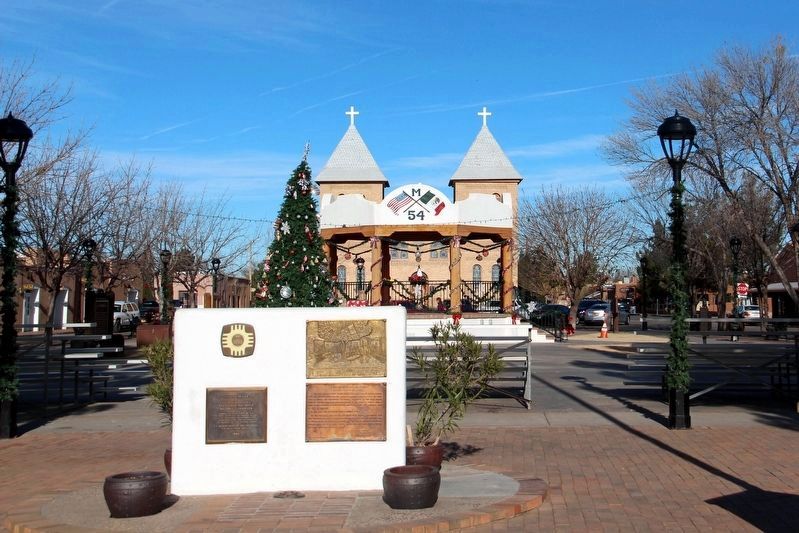
Established in
Mexican Territory, 1850.
U.S. Flag Raised July 4, 1854.
Seat of Confederate Government
in New Mexico, 1861-1862.
Site No. 14
A Registered Cultural Property
State of New Mexico — — Map (db m196766) HM
This park commemorates Smokey Bear and describes the history and development of this national symbol of forest fire protection. The original Smokey is buried here within sight of the mountain where he was found orphaned by a fire raging in the . . . — — Map (db m119757) HM
Just 10 miles west on US Highway 380 you will discover one of New Mexico’s hidden treasures, the town of Lincoln. Tucked away in the beautiful Bonito River Valley, Lincoln has barely changed since the Lincoln County War (1878-1881). Lincoln is . . . — — Map (db m79141) HM
This farming and ranching community was the scene of many events associated with the Lincoln County War. In July 1878, a posse ransacked the village while looking for William "Billy the Kid" Bonney and others of the faction known as the "Regulators" . . . — — Map (db m46005) HM
Shortly after Civilian Conservation Corp. camp
DF-17-N was established in 1933 under the New
Deal, it was renamed Camp Saturnino Baca for
the founder of Lincoln County. Abandoned after
one summer, it reopened in 1935 for five years
as one of . . . — — Map (db m235397) HM
Part original structure. Famous landmark for 100 years. Originally grist and sawmill. Used as rendezvous by William H. Bonney (Billy, the Kid), Pat Garrett, Johnny Riley, J.J. Pershing (then Lt. at Ft. Stanton) and other historic figures. — — Map (db m46014) HM
Columbus was founded in 1891 as a U.S./Mexico border station but eventually coalesced around the railroad station three miles to the north in 1903. The area’s history is tied to a March 9, 1916, raid on Columbus by Mexican revolutionary leader . . . — — Map (db m37778) HM
Columbus was founded in 1891 as a U.S./Mexico border station but eventually coalesced around the railroad station three miles to the north in 1903. The area’s history is tied to a March 9, 1916, raid on Columbus by Mexican revolutionary leader . . . — — Map (db m37780) HM
Located on the rugged slopes of the Florida Mountains, this is one of the most unusual parks in the nation. Here "rockhounds" are encouraged to take home samples (up to 15 pounds) of rocks and minerals. The park also offers camping and picnicking . . . — — Map (db m72718) HM
Long a major trading center for the Navajo and Zuni Indians living in communities north and south of the town. Gallup emerged in 1881 from a railroad construction camp. It is named for David Gallup, who in 1880 was paymaster for the Atlantic & . . . — — Map (db m36541) HM
For the Mescalero Apache, Dog Canyon was a favorite camping area and trail through the Sacramento Mountains. It was the scene of several battles in the 19th century. In 1863 a group of Mescaleros was attacked by soldiers, and the survivors were sent . . . — — Map (db m72719) HM
Located in the Tularosa Basin east of the great lava flows known as the malpais, Three Rivers was once prominent in the cattle empires of Albert Bacon Fall, John S. Chisum, and Susie McSween Barber, “the cattle queen of New Mexico.” . . . — — Map (db m46039) HM
Inhabitants of a nearby village made the Three Rivers Petroglyphs (rock carvings) over 600 years ago. Over 20,000 petroglyphs have been identified in the area. The people were of the Jornada Mogollon (hor-NAH-da muggy-OWN) prehistoric Indian . . . — — Map (db m46042) HM
Three miles to the east is a mile-long array of pictures pecked into the solid rock walls of a volcanic ridge. They include both geometric and animal forms. They were likely made by prehistoric Mogollón Indians between ca. A.D. 1000 and 1400. — — Map (db m46040) HM
The Tularosa Basin has been occupied by Indian groups for thousands of years. The first Hispanic settlers moved here from the Rio Grande Valley in 1862. Anglo settlers and cattlemen began moving into the region in the 1870s. The original 1862 . . . — — Map (db m46072) HM
Governor Juan de Oñate set up his headquarters in San Juan Pueblo in 1598, but by 1601 he had moved the Spanish capital across the Rio Grande to Yuque-Yunque Pueblo. Named San Gabriel, it served as the seat of government until 1610, when Oñate's . . . — — Map (db m32877) HM
Aztec, named for the nearby National Monument, was founded in 1876 when portions of the Jicarilla Apache Reservation were opened for non Indian settlement. It is the seat of San Juan County, which was created in 1887 partially as a response to the . . . — — Map (db m36464) HM
Prehistoric farmers established major communities along the rivers of this region in the eleventh century. Eight hundred years later, historic settlement was also made possible by abundant water. Bloomfield was established in 1879 near a site which . . . — — Map (db m36460) HM
In the late 11th century, influence from Chaco Canyon, 45 miles south of here, began to be felt at this site and at nearby Aztec Ruins National Monument. The Chacoans abandoned this large and well-built masonry pueblo by 1150, and shortly . . . — — Map (db m36457) HM
Until 1876 this area comprised part of the Jicarilla Apache Reservation. Anglo settlement quickly began at the confluence of the San Juan, Animas, and La Plata Rivers. Farmington became a ranching and farming area and, later, an important producer . . . — — Map (db m36469) HM
In 1868, U.S. Surveyor Ehud N. Darling surveyed the 37 parallel of latitude to establish the territorial boundary of Colorado and New Mexico. He placed specially marked stones at intervals along the surveyed line that started at the northeast . . . — — Map (db m36529) HM
From 1863 to 1867, this mountain was the home of Juan Maria Agostini, an Italian penitent who lived there as a hermit, carving crucifixes and religious emblems which he traded for food. Leaving this area, he moved to the Organ Mountains, in southern . . . — — Map (db m73309) HM
Between Sapello and Mora, State Road 3 follows a narrow strike valley eroded into soft shale between ridges of resistant sandstone called hogbacks, both the result of uplift of the Rocky Mountains. To the east stretch the Great Plains, and to the . . . — — Map (db m73283) HM
Prominent landform of north-eastern New Mexico that extends for almost 100 miles
between Las Vegas and Clayton. From this point, the grass-lands
of the High Plains reach northwestward to the foot of the Southern Rocky Mountains which rise to . . . — — Map (db m144177) HM
Near here the Rio Grande Valley closes into a narrow pass (angostura). Control of this pass was critical to the safety of the trade along the Camino Real, so this area has been the focus of fortifications since the early 17th century. The 18th . . . — — Map (db m32800) HM
The Keres-speaking pueblo of Santa Ana was established on its present site in 1693, as part of Diego de Vargas' reconquest of New Mexico. The spot, exposed to flooding, was poorly suited for farming, and today the residents live on their farms along . . . — — Map (db m32843) HM
By proclamation of the City Council, Santa Fe celebrated its 375th anniversary. During the year, this property was donated to the city by Archbishop Robert Sanchez and the Santa Fe Fiesta Council. These gifts, together with appropriations by the . . . — — Map (db m76319) HM
Why is it called Lake Valley? The town was originally located north of here, and during the 1870's derived its name from nearby relic lake beds. At that time it was just a small stage stop. That location was flooded, and the small settlement was . . . — — Map (db m97440) HM
Mystery in ruins On December 17, 1853 – almost 175 years after the Tompiros and Franciscans left – a U.S. Army expedition came upon Abó. Their leader, Major James H. Carleton, wrote:
In the mystery that envelops everything . . . — — Map (db m235528) HM
Numerous salt ponds and lakes of which Laguna del Perro is the largest, occur in the lowest part of the Estancia basin, a closed depression between the Manzano Mountains to the west and the lower Pedernal hills to the east. The Basin was filled by a . . . — — Map (db m75513) HM
The late 1800s were a time of homesteading and private acquisition of public lands. Conservationists began working to preserve some public lands like Yellowstone and Yosemite. In 1891, the General Land Office of the Department of the Interior . . . — — Map (db m89224) HM
This region of volcanic activity is the Raton-Clayton Volcanic Field. It has been active periodically, beginning at the western edge of the field with the Raton Phase from 9 to 3 million years ago. The Capulin Phase began about 1 million years ago . . . — — Map (db m89228) HM
Capulin Volcano directly in front of you is a dramatic example of the volcanic processes that shaped northeastern New Mexico. Capulin Volcano National Monument preserves this classic cinder cone. About 60,000 years ago thunderous explosions sent . . . — — Map (db m89223) HM