In Memory of
Marilyn Anne McKinney
President of the Rhodi Bowie
Family Historical Society
from 1989 until her death June 17, 1995. She was an outstanding leader earning our love and support. — — Map (db m20781) HM
On Mount Carmel Road (South Carolina Route 823) at Mulberry Road, on the right when traveling south on Mount Carmel Road.
(Front)
The formal organization of Mulberry A.M.E. Church dates to c. 1871, but many of the founding members were formerly enslaved people who had a tradition of religious organization that stretched back into slavery. Early meetings were . . . — — Map (db m238574) HM
On West Main Street (State Highway 184) south of Austin Road, on the right when traveling south.
Dedicated to
Jane Byrd Wilson
Sept. 19,1939 - March 17, 2000
She worked to preserve the valuable
heritage of the Boonesborough Township — — Map (db m12103) HM
On SC Highway 184, on the right when traveling north.
The Donalds Grange No. 497 is significant for both its architecture and its contribution to the social development of the community and Abbeville County. For these reasons, Donalds Grange No. 497, Patrons of Husbandry, was entered into the . . . — — Map (db m12112) HM
On Depot Street, on the left when traveling north.
Named after the city in France, Abbeville County has a rich historical and cultural heritage. The town of Abbeville, the county seat, is known for its quaint tree-lined square with bricked streets; the famous 1908 historic Opera House and its . . . — — Map (db m14843) HM
On College Street (State Highway 186) at Alexander Street, on the right when traveling north on College Street.
The initial gift and a substantial contribution toward the construction of this sign were donated by members of the Class of 1995 as a memorial to their classmate, Angela Marlow Newton, whose untimely death in her senior year at Erskine College . . . — — Map (db m12098) HM
On South Main Street, on the right when traveling south.
In gratitude for the lasting benefits Bryson College provided for so many students, her Alumni and Friends have provided this Memorial Fountain to perpetuate the "Associate Reformed Presbyterian College in the West." This fountain is dedicated in . . . — — Map (db m14782) HM
On North Main Street (State Highway 184) at College Street (State Highway 20), on the left when traveling south on North Main Street.
As early as 1765 the site 6 miles NW known to the Indians as Yellow Water, where the Keowee Path crossed the Cherokee line, was called DeWitt's Corner. In 1777 a treaty between S.C. and the Cherokee Indians was signed there. The present town was . . . — — Map (db m10602) HM
Erskine College was founded in 1839 by the Associate Reformed Presbyterian Church as South Carolina's first four-year church-related college. The college grew out of an academy for men established in 1835 and seminary founded two years later at . . . — — Map (db m14793) HM
Southwest Side:
Founder
of the
Due West Female College
and for near twenty two years
its
President
1859-1881
Northeast Side:
Erected
By the Alumnae and
affectionately inscribed
to the Memory of . . . — — Map (db m15790) HM
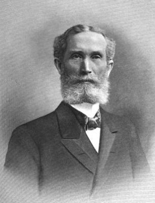
Citizen, Soldier,
Educator,
Servant of Christ.
Born Feb. 11, 1843
Died Sept. 3, 1899.
President of
Erskine College
from 1871 to 1899.
His service is
measured not by
years but by results.
He still lives in
hundreds of useful . . . — — Map (db m14835) HM
On Hampton Avenue Northeast at Kershaw Street Northeast, on the right when traveling east on Hampton Avenue Northeast.
This park is the site of Aiken Graded School, a two-story brick school built 1924-25. It was built for black pupils in grades 1-7 and was one of almost 500 S.C. schools funded in part by the Julius Rosenwald Foundation 1917-1932. Black Aiken . . . — — Map (db m239018) HM
On Whiskey Road (State Highway 19) near Colleton Ave Southeast, on the right when traveling north.
The Aiken Institute, which gave this area the name of “Institute Hill,” was chartered in 1888. The main building, designed by I.F. Goodrich in 1891, includes a wing added in 1913. All grades attended the Institute until 1937, when a . . . — — Map (db m9942) HM
On Barnwell Avenue NW east of Lancaster Street, on the right when traveling east.
(Front)
Aiken Preparatory School (APS), founded in 1916 as a boarding school for “junior gentlemen” in grades 4-8, was a fixture in the city of Aiken for almost 100 years. Louise “Lulie” Hitchcock (1867-1934), a leader among the wealthy . . . — — Map (db m238832) HM
On Laurens Street SW at Hoods Lane SW, on the right when traveling north on Laurens Street SW.
"Aiken Needs a Library Building."
Aiken had a subscription library as early as the 1870s but it was a floating library moored in private homes, stores, and downtown buildings. There was no permanent building and this lack became a rallying . . . — — Map (db m239078) HM
On Laurens St SW, on the right when traveling south.
Josef Casimir Hofmann, internationally
known Polish pianist, resided with his
wife, Aikenite Marie Eustis Hofmann, in
a three~story house located several
hundred feet west of here. Born near
Cracow, Poland, he was recognized as a
gifted . . . — — Map (db m10184) HM
On Kershaw Street NW, on the right when traveling north.
This school was founded by the Freedmen's Bureau shortly after the Civil War to educate freedmen, women, and children. In 1868 Martha Schofield, a Quaker from Pennsylvania, came to Aiken and began her long career as superintendent. The school soon . . . — — Map (db m28821) HM
On Williston Road (U.S. 278) near Hammond Road, on the left when traveling east.
Downer Institute & School
Downer Institute, founded in 1843, was originally located 1.5 mi. NE of this site and operated until 1865. It was named for benefactor Alexander Downer (1752–1820), whose will established an orphanage and school . . . — — Map (db m9994) HM
On Johnston Highway (State Highway 191) 0.2 miles north of State Highway 19, on the right when traveling south.
This house was for many years the home of Marie Cromer Seigler (1882-1964), educator and national pioneer in agricultural instruction. In 1910, as teacher and principal of Talatha School, she founded a Girls' Tomato Club, the first of many such . . . — — Map (db m28714) HM
On Canal Street (State Highway 191) at Gregg Highway, on the right when traveling north on Canal Street. Reported missing.
(Front)
This Carpenter Gothic school was built in 1848 by the Graniteville Mill, then the largest textile mill in S.C. William Gregg (1800-1867), who opened the mill in 1847, created a model mill village here. This academy, with five . . . — — Map (db m238811) HM
On Canal Street (South Carolina Route 191) at Church Street, on the right when traveling north on Canal Street.
(Front)
This Classical Revival school, built by the Graniteville Mill in 1921-22, was designed by noted Augusta architect Willis Irvin (1890-1950) and was called “the finest school in the state” when it was dedicated. An elementary and high . . . — — Map (db m238809) HM
On West Railroad Avenue (State Highway 39) near Pine Street, on the left when traveling north.
(Front)
A patriot and Christian
devoted to his country, his
family and his god.
He served his country well
as a member of Hart's Battery
and died loving the cause
for which he fought.
Dempsey Hammond Salley was
. . . — — Map (db m47645) HM
On Huber Clay Road (State Highway 66) at Shephard Estates Drive, on the left when traveling south on Huber Clay Road.
Jacksonville School
Jacksonville School, built by the Jacksonville Lodge in 1895, taught the black children of this community until 1936. Grades 1-7, with two teachers, met in two classrooms on the first floor, without electricity or running . . . — — Map (db m31175) HM
On Flint Drive (State Highway 731) west of Bryan Drive, on the right when traveling east.
Jefferson High School Jefferson High School opened in 1956 as a junior high and high school for African-American students of Beech Island, Belvedere, Graniteville, Jackson, Langley-Bath-Clearwater, and North Augusta, with Herman W.W. Fennell . . . — — Map (db m31675) HM
On South McDuffie Street, on the right when traveling north.
This archway
formerly stood at the
entrance to
Anderson Boys'
High School
"Home of the Yellow Jackets"
Anderson Boys' High School
was located on this site.
The school educated many of
our city's young men from
the year . . . — — Map (db m59359) HM
This building constructed in 1912
is named in honor of
Dr. Annie Dove Denmark
associated with Anderson College for
36 years, serving as President of the
college from 1928-1953. Dr. Denmark
was a resident of this dormitory
during . . . — — Map (db m19738) HM
Miss Sarah Jane (Janie) Frierson was a well known educator and the daughter of Dr. David Frierson, an early pastor of the First Presbyterian Church of Anderson. Miss Frierson opened her one room school in the late 1880s. One room schools of this . . . — — Map (db m42189) HM
On East Greenville Street (State Highway 81), on the right when traveling south.
The Anderson County Museum is situated on the former site of Anderson Girls High School. The original structure, an imposing multi-story brick building, was built in 1918. At that time, both boys and girls attended the school known as Anderson . . . — — Map (db m42249) HM
On South McDuffie Street, on the right when traveling north.
McDuffie High School stood
proudly at this location from
1964 until 1996. Serving
Anderson as a comprehensive
vocational high school,
McDuffie enrollment averaged
1000 students each year it was
open. Many of Anderson's
current . . . — — Map (db m59360) HM
This building constructed in 1912
is named in honor of
Dr. and Mrs. R.N. Pratt
Outstanding Teachers
at Anderson College
Dr. Pratt - 1922-1927
Mrs. Pratt - 1922-1946 — — Map (db m19745) HM
On West Reed Street at South Towers Street on West Reed Street.
After another high school was built, Reed Street High was renamed Perry Elementary School.
Perry Elementary later became known as
Perry Child Development Center.
This memorial is dedicated to the students teachers and principals who were a . . . — — Map (db m60542) HM
This building was donated to
Anderson College in 1914 by
Mr. Charles S. Sullivan, Sr.
to be used as the President's Home.
In 1965 it was renovated to serve
as the music building. — — Map (db m19804) HM
On South Fant Street, on the left when traveling south.
The Horace Greeley Institute Trust was established in 1870 in the name of abolitionist Horace Greeley. Because the trust was to be used for the advancement of the education of "Freedmen and their Children," a school, known as the Greeley Institute, . . . — — Map (db m61078) HM
On Kingsley Road, on the right when traveling north.
In Memory of
Henry Hitt Watkins
1866-1947
and
Maude Wakefield Watkins
1870-1963
This building was made possible through the generosity of Judge and Mrs. Watkins, the South Carolina Baptist Convention, and other dedicated friends . . . — — Map (db m19816) HM
On Kingsley Road, on the right when traveling north.
Erected 1962-63
Named in honor of
Dr. John Edward Rouse
Baptist Leader, Friend of Youth
Champion of Education
President of Anderson College 1957-73
This dormitory is named to honor him
in grateful recognition of
his . . . — — Map (db m19829) HM
On South Main Street (State Highway 28) at Johnson Street, on the right when traveling south on South Main Street.
Three educational institutions have been in this immediate area: Johnson Female University (1856-63) named for William Bullein Johnson; the Carolina Collegiate Institute (about 1866-90) under W. J. Ligon; and Patrick Military Institute (1887-1900), . . . — — Map (db m10524) HM
Whyte House
The west wing of this building was
constructed in 1920 and is named
in honor of
James Primrose Whyte
Dean and beloved Professor of
Literature and Sociology at
Anderson College from 1918 to 1922.
John E. White . . . — — Map (db m19784) HM
On South Manning Street near East Church Street, on the left when traveling south.
President of Triennial Southern, South Carolina Baptist Conventions. Johnson Female University founded here in 1848 as Johnson Female Seminary was named for him because of his support for female education. From 1853 to 1858, while Chancellor of . . . — — Map (db m10526) HM
On South Fant Street at East Whitner Street, on the right when traveling north on South Fant Street.
This facility was originally built in 1951 and was the cafeteria for the McCants Middle School. Renovation of the space for Meals on Wheels was completed in 2000 to allow for the expansion of the successful community program, which was begin in . . . — — Map (db m59442) HM
This building served as a classroom and
dormitory for the former Union High School
Dedicated
"To The Glory of God"
July 20, 1991
The Reverend R.H. Mitchell -- Moderator at Renovation
Dr. Earl J. Mathis -- At Dedication
. . . — — Map (db m10752) HM
On North Shirley Avenue, on the left when traveling east.
Honea Path is the smallest town of the fourteen South Carolina communities with libraries funded by the Andrew Carnegie Foundation. Dr. John Wright, Mayor John Humbert, and Miss Jennie Erwin were leaders in obtaining the $5000 grant. The Honea . . . — — Map (db m10759) HM
On Lebby Street (State Highway 8) just east of Hale Street, on the left when traveling east.
The first Pelzer Mills School, built in 1881, was a two-story frame building. The school was described as having "the air of a city school" and the mill funded a ten-month term at a time when three-months was common. The school was free and open to . . . — — Map (db m234255) HM
On Easley Highway (South Carolina Route 8) at Midway Road, on the right when traveling south on Easley Highway.
(Front)
Previously housed in a log cabin 1/2 mi. E, White Plains School moved to this site by 1890. At least sixty pupils attended the one-room frame school, which served white families from the White Plains community. The first teacher at . . . — — Map (db m238534) HM
This area was a hub of African-American life from the late-19th to mid-20th centuries. Anderson County Training School, built ca. 1922 as a Rosenwald school, closed in 1954 under the equalization program for black and white schools. It burned in . . . — — Map (db m54824) HM
On Vance Street, on the right when traveling west.
The one-room frame public school organized shortly after the Civil War, housed 76 students and 1 teacher by 1870. The school term lasted 1 month and 10 days. Jane Harris Hunter, founder of the Phillis Wheatley centers for working girls, attended . . . — — Map (db m9647) HM
On Clemson Boulevard (State Highway 76) at State Highway 175, on the right when traveling north on Clemson Boulevard.
In recognition of Dr. Don C. Garrison for his thirty-two years of devoted service as the second president of the College for his dynamic leadership within the College, the State technical college system, and community colleges nationwide; for his . . . — — Map (db m18857) HM
On Lebanon Road at Autun Road, on the right when traveling north on Lebanon Road.
Directly behind this marker is the homesite of Joe and Mary Broyles Douthit. Born in Anderson County January 30, 1893, graduate of Clemson University, 1914. Farmer and seed breeder, lifelong member and steward of Sandy Springs United Methodist . . . — — Map (db m52075) HM
On Cherry Street Extension (State Highway 115), on the right when traveling east.
Born in 1840, Colonel Simpson, lawyer, farmer, and legislator, drafted and executed Thomas Green Clemson's will, establishing Clemson Agricultural College in 1889. Simpson was first president of the college's board of trustees and once owned land . . . — — Map (db m9682) HM
The paved brick walk leads to the gravesite of Thomas Green Clemson, founder of Clemson University. He was a Scientist, Agriculturist, Statesman, and Educator. His gift to South Carolina of an Institution for the promotion of education in the fields . . . — — Map (db m13938) HM
On East Queen Street, on the right when traveling east.
A native Philadelphian and leading agriculturist, Mr. Clemson was U.S. charge d'affaires to Belgium, U.S. Superintendent of Agriculture, and the 1868 president of Pendleton Farmers Society. He married the daughter of John C. Calhoun, Anna, . . . — — Map (db m9681) HM
On Anderson Highway (State Highway 28 / 76) 0.1 miles south of Excelsior Mill Road.
Dedicated in 1979
in Honor of
Thomas Green Clemson
1807-1888
A Native Philadelphian and
Leading Agriculturist. Mr.
Clemson was U.S. Charge
D'Affaires to Belgium, U.S.
Superintendent of
Agriculture, and the
1868 President . . . — — Map (db m16617) HM
On West Main Street (State Highway 20) 0 miles east of Minor Street, on the right when traveling south.
This college was founded Feb. 12, 1872, by the Reverend Samuel Lander, D.D., Methodist minister. On this site stood the college building until 1939. The school was removed to Greenwood, S.C., Sept. 27, 1904, becoming Lander College, in honor of . . . — — Map (db m8440) HM
Near West Main Street (State Highway 20) west of Minor Street.
This site and the one directly in front, Mineral Spring Park, which was donated by West Allen Williams in 1842, formed the nucleus for the new Town of Mineral Springs. In 1852, the town received its charter and the name was changed to Williamston . . . — — Map (db m19733) HM
On South Carlisle Street at Midway Street, on the left when traveling south on South Carlisle Street.
SC Methodists began an institution on this site in
1892 naming it Carlisle Fitting School, for James H.
Carlisle, president of Wofford College 1875-1902.
It served as a coeducational preparatory institution
for Wofford. Col. James F. Risher . . . — — Map (db m26427) HM
On Columbia Highway (U.S. 321) 0.1 miles north of Heritage Highway (U.S. 78), on the right when traveling north.
Side 1
Denmark High School is the second school located at this spot. The first Denmark School, designed by Charles Coker Wilson, was completed in 1908 and once stood adjacent to the current building. The core of the current school was . . . — — Map (db m180068) HM
On East Voorhees Road (State Highway S-5-12) near Soloman Blatt Boulevard, on the right when traveling east.
[Front Text]
Voorhees College, founded by Elizabeth Evelyn Wright
in 1897 as the Denmark Industrial School, was an
effort to emphasize a vocational curriculum for
rural African American students on the model of
the Tuskegee Institute. . . . — — Map (db m19639) HM
The Barnwell Ring
In 1941 Barnwell County was home to four of the most powerful men in South Carolina government. Serving for a time simultaneously,
Edgar A. Brown, Chm. of the Senate Finance Committee
J. Emile Harley, Governor
Pres. . . . — — Map (db m95192) HM
The lifetime of William Gilmore Simms, the preeminent man of letters in the Old South, embraced an era of American history marked by nullification, states rights, secession, war and reconstruction.
He responded to these crises by writing and . . . — — Map (db m95193) HM
On State Highway 3, on the right when traveling south.
Named In Honor
Of
"Mr. Speaker"
who has traveled this road
between Barnwell and Columbia
thousands of times
as
member, House of Representatives
since 1933
Speaker of the House
1937 — 47 1951 —73
A . . . — — Map (db m55175) HM
On Boiling Springs Rd (State Highway S-6-39) near Lyndhurst Road (State Highway S-6-121), on the right when traveling west.
[Marker Front]:
Boiling Springs Academy was founded by the Boiling Springs Academical Society in 1823, with trustees Hansford Duncan, John Fowke, James Furse, William Gillette, Gideon Hagood, Frederick Hay, Lawrence Hext, James . . . — — Map (db m8666) HM
On Carteret Street (U.S. 21), on the right when traveling west.
Beaufort College, a college preparatory academy founded in 1795, occupied this Greek Revival building from 1852 to 1861. The school opened in 1804 at Bay and Church Sts. but closed in 1817 after a yellow fever epidemic, reopening in 1820 at . . . — — Map (db m218213) HM
Near Craven Street just east of Scott Street, on the right when traveling east.
Welcome to Reconstruction Era National Historical Park. This unit of the national park system was established in January 2017 to preserve and interpret the resources and complex national stories of Reconstruction — African Americans' quest for . . . — — Map (db m227256) HM
On Ribaut Road (State Highway 281) 0 miles south of Reynolds Street, on the right when traveling south.
Shortly after the Civil War, Mather School was founded here by Rachel Crane Mather of Boston. In 1882 the Women's American Baptist Home Mission Society assumed support of the venture, operating it as a normal school for black girls. With some . . . — — Map (db m6940) HM
On Craven Street at Church Street, on the right when traveling west on Craven Street.
Maxcy - Rhett House
This house was built circa 1810 for Milton Maxcy (1782-1817), who came here from Massachusetts in 1804. Maxcy and his brother Virgil, who founded a school for young men in Beaufort, later taught at Beaufort College. In the . . . — — Map (db m218490) HM
On Craven Street at Carteret Street (Business U.S. 21), on the left when traveling east on Craven Street.
Built in 1917-18, this was one of fourteen libraries constructed in S.C. with funding from the Carnegie Corporation. It was built at the urging of the Clover Club, a local women's literary group who in 1902 began a small subscription library. The . . . — — Map (db m223614) HM
(Front text):This is the site of two schools
that served the black community of southern Beaufort County for most of the twentieth century. Bluffton Graded School, a small frame building constructed about
1900, was followed in 1954 by an . . . — — Map (db m5853) HM
Near Okatie Highway (State Highway 170) near Okatie Center Boulevard, on the right when traveling south.
The name Barrel Landing (also spelled Barrell) comes from a nearby docking and landing area on the Okatie River initially used by early settlers of the Okatie community in the period following the Revolutionary War. Farmers and tradesmen used the . . . — — Map (db m15320) HM
On Dillon Rd at City Beach Rd, on the right on Dillon Rd.
(Front)
This one-room frame school, built ca. 1937, was the first separate school building constructed for African-American students on Hilton Head Island. It replaced an earlier Cherry Hill School, which had held its classes in personage of St. . . . — — Map (db m104496) HM
Near Beach City Road, 0.4 miles north of Dillon Road, on the right when traveling north.
Religion in Mitchelville
Before Mitchelville was established, African slaves on the island congregated at impromptu religious services under trees. The churches built in Mitchelville were the center of religious, social, political, and . . . — — Map (db m105172) HM
In Honor Of
Edith M. Dabbs
for her work and leadership in preserving
historic documents and photographs of Penn
School and for her contributions as author of
Face of an Island and Sea Island Diary
and
James McBride . . . — — Map (db m13432) HM
On Dr. Martin Luther King Drive (State Highway S-7-45), on the right when traveling south.
[front text]
One of the first schools for blacks in the South, Penn School, was reorganized as Penn Normal, Industrial and Agricultural School in 1901. As a
result of this change, incorporating principals of education found at both . . . — — Map (db m20294) HM
On Trask Parkway (U.S. 17 / 21) 0.1 miles north of Sheldon Drive when traveling north.
(Front):
Sheldon Union Academy, later Sheldon School, opened in 1893 on this site and educated the black children of rural Sheldon community for almost fifty years. The original Sheldon Union Academy board, which founded and governed the . . . — — Map (db m5785) HM
In the early dawn of January 9, 1861, the first shot of the War Between the States was fired from Morris Island by Citadel cadets under the command of Major Peter Fayssoux Stevens. The cadets opened fire with 24 pound siege guns on a Federal ship, . . . — — Map (db m67853) HM
On Jenkins Avenue at Jones Avenue, on the right when traveling west on Jenkins Avenue.
In memory of Major Sam M. Savas, Jr., CE, USA Citadel 1951 Died in Vietnam, 1965 In memory of Lt. Sam M. Savas, III, USN Naval Aviator Citadel 1979 Died in the service of his country October, 1985 — — Map (db m67855) HM
On Howe Hall Road near Red Bank Road, on the left when traveling east.
(Front text) Howe Hall Plantation Howe Hall Plantation was established here by Robert Howe about 1683 and passed to his son Job Howe (d. 1706), Speaker of the Commons House of Assembly 1700-05. Later owned by such prominent lowcountry . . . — — Map (db m28079) HM
On Foster Creek Road at Ford Boulevard on Foster Creek Road.
Bowen's Corner, an African-American farming community from the mid-19th century through the late-20th century, was originally part of a rice plantation established along Goose Creek in 1680. That tract was granted by the Lords Proprietors to Barnard . . . — — Map (db m29500) HM
On North Live Oak Drive (U.S. 17), on the right when traveling north.
(Front text) Berkeley Training High School, located here from 1955 to 1970, replaced a four-room wood school 1 mi. S at Main St. and Old U.S. Hwy. 52. That school, built in 1918-1920 at a cost of $6,700, had been partially funded by the . . . — — Map (db m41606) HM
On Main Street (State Highway 6) at U.S. 52 on Main Street.
[Front] Berkeley Training High School, first called Dixie Training School, stood here from 1920 until the 1980s. The first public school for blacks in Moncks Corner was founded in 1880. It held classes in local churches until its first . . . — — Map (db m29133) HM
On State Highway 45, on the right when traveling west.
Named in honor
of
St. Stephen Native
Teacher and Principal
For Over 30 Years
Member
St. Stephen Town Council
1970-1979
Mayor Pro Tem
1974-1979
9th District member
S.C. Highway Commission
1972-1982
Member
House of . . . — — Map (db m29419) HM
On Russellville Road (State Highway 8-18) at Cedar Drive, on the left when traveling west on Russellville Road.
(Marker Front)St. Stephen Colored School St. Stephen Colored School, the first public African American school in St. Stephen, was built here in 1924-25. A three-room frame building, it was one of almost 500 schools in S.C. funded in part . . . — — Map (db m29334) HM
Near Meeting Street at Tobacco Street, on the right when traveling south.
Dates of Historical Interest
1822 First constructed as a two-storied armory and fortress as a result of the Denmark Vesey slave uprising.
1842 Occupied by the first Corps of Cadets of the Military College of S.C. (20 students). . . . — — Map (db m242715) HM
Near George Street at Meeting Street, on the right when traveling west.
The trustees of the College of Charleston laid the foundations of this building on the 21st day of December 1938 Erected by the City of Charleston with the aid of the income from the College Endowment it is dedicated to the physical well-being of . . . — — Map (db m135493) HM
Near Calhoun Street east of Concord Street when traveling east.
Septima Poinsette Clark was born in Charleston, South Carolina in 1898, the daughter of Victoria Anderson of Haiti and Peter Poinsette, who grew up enslaved on the plantation of Joel Roberts Poinsette. Clark earned a teacher's certificate from The . . . — — Map (db m134228) HM
Native Charlestonian and daughter of a former lowcountry slave, Mrs. Septima Clark was a leader of the Civil Rights Movement. A graduate of Avery Normal Institute, Clark's first job was teaching African-American children on Johns Island. Her . . . — — Map (db m64797) HM
On President Place near President Street, on the left when traveling west.
The Parsonage“The Parsonage,” the home of Rev. James B. Middleton (1839-1918), stood here at 5 Short Court (now President’s Place) until 1916. Middleton and his siblings, born slaves, were taught to read and write by their father, . . . — — Map (db m39449) HM
On Franklin Street near Poulnot Lane, on the left when traveling south.
In 1891 the Reverend Daniel J. Jenkins established a home and school for poor, black orphans and for children of poor, distressed and disabled parents. It was his desire "to train the minds and hands of young, black boys and girls so that they could . . . — — Map (db m48701) HM
On Queen Street east of King Street, on the left when traveling west.
(front)
Jonathan Jasper Wright (1840-1885), the first African American in the U.S. to sit as a justice on a state supreme court, practiced law here from 1877 until his death in 1885. Wright, a native of Pa., was educated at Lancasterian . . . — — Map (db m206018) HM
On Pitt Street, on the right when traveling south.
This was the home of sisters Carrie (1881-1974), Mabel (1885-1979), and Anita Pollitzer (1894-1975), longtime activists for women’s rights. Anita, an artist and wife of press agent Elie C. Edson, played a pivotal role in the passage and ratification . . . — — Map (db m39448) HM
On Market Street at King Street, on the left when traveling east on Market Street.
The Riviera Theatre was constructed in 1939
by Albert Sottile, President of Pastime
Amusement Company. The Art Deco architecture
is in the Egyptian style. It served the Charleston
community as a motion theatre until 1978. The
theatre is . . . — — Map (db m40015) HM
On Wentworth Street west of Glebe Street, on the right when traveling east.
(side 1) Septima Poinsette Clark, who Martin Luther King Jr. called "the Mother of the Movement," was a nationally influential Civil Rights activist. She was born at 105 Wentworth St. on May 3, 1898 to Peter Poinsette, a former slave, and . . . — — Map (db m133641) HM
On Saint Philip Street just north of Beaufain Street, on the right when traveling south.
This land, granted 1680 to John Coming, is part of the glebe given in 1698 to the English Church by Mrs. Affra Coming. The provincial library established in 1698 was in St. Philip’s Church Parsonage which stood on this site until 1858 when a girls’ . . . — — Map (db m141259) HM
On Archdale Street south of Clifford Street, on the right when traveling north.
This church grew from services held for German inhabitants in Charleston by Rev. Johann Martin Boltzius in 1734 and Rev. Henry Melchior Muhlenberg in 1742. The cornerstone of the first house of worship was laid in 1759; the second and present church . . . — — Map (db m11228) HM
On Meeting Street near Broad Street, on the right when traveling south.
In January 1868 delegates met to rewrite the S.C. Constitution. They convened at the Charleston Club House, which once stood near here. Before the Civil War the Club House was reserved for Charleston's planter elite, but a majority of the delegates . . . — — Map (db m115228) HM
Near Meeting Street south of Saint Michaels Alley, on the right when traveling south.
Native of Barnwell, South Carolina. Only child of South Carolina Speaker of the House, Solomon, and Ethel Blatt. World War II Naval Officer. This esteemed jurist served on the United States District Court in Charleston from 1971-2016 as the . . . — — Map (db m135488) HM
558 entries matched your criteria. The first 100 are listed above. Next 100 ⊳