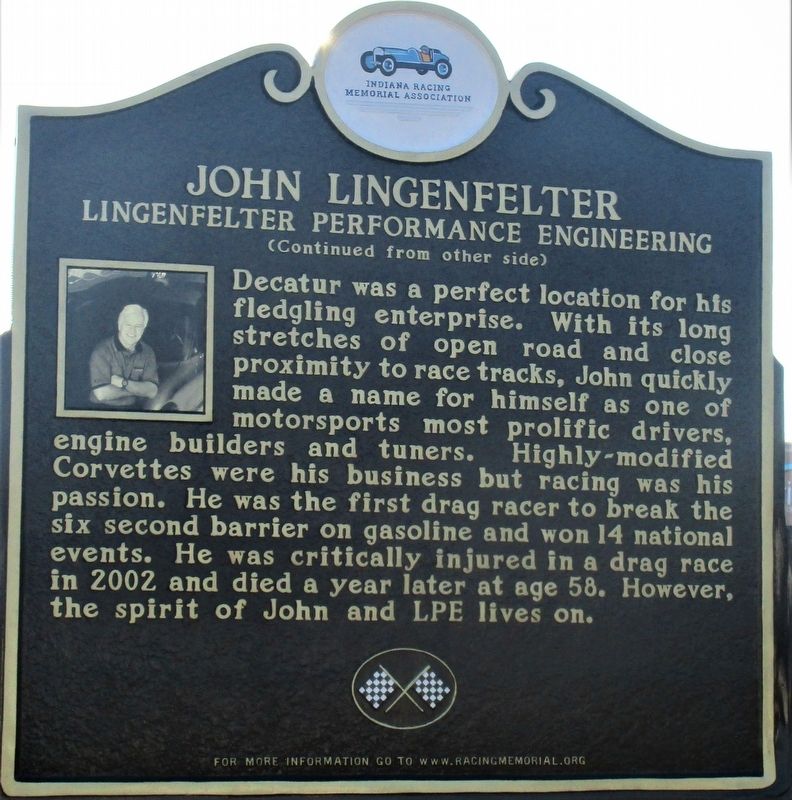
Maybe it was foretold that Pennsylvanian born John Lingenfelter would become one of racing's most legendary engine builders. The gifted son of a mechanic, John began working on cars almost as soon as he could hold a wrench. A move to Indiana to . . . — — Map (db m168283) HM
Adams County formed 1835. Geneva incorporation 1874 included early towns Alexander and Buffalo. During 1890s oil boom, population and businesses grew. Fire destroyed much of town 1895; Geneva Board of Trustees banned wooden buildings, mandated . . . — — Map (db m63824) HM
Fort Wayne business had a start on Duck Street, named for the 19th century Duck Creek that drained the area from the higher ground near Superior Street into the St. Mary’s River. Along Duck Creek in the 1840s and 50s stood the City Mills, one of the . . . — — Map (db m16997) HM
The Wabash & Erie Canal was instrumental in the construction of the first railways in Fort Wayne, which quickly became a railroading center in the Midwest. In 1852, along the canal at the present-day railroad elevation that borders the south edge of . . . — — Map (db m16996) HM
Johnny Appleseed legendary planter of orchards across Ohio, Indiana, and Illinois, was a real person named John Chapman. He was a friend to all God's creatures and a missionary for the Swedenborgian religion, a Christian denomination.
He was . . . — — Map (db m21560) HM
Only land barrier
on shortest trade route
between Quebec and
New Orleans.
Eastern landing of eight-
mile carry from St. Mary's
to Little River. Used by
Indians, French, British
and American traders. — — Map (db m21061) HM
The Barr Street Market is the oldest
market in Fort Wayne. The land was
donated to the city by Samuel Hanna in
1837, and within six months a small
frame market house was built; merchants
rented stalls for $5 per year.
and the market were named . . . — — Map (db m197286) HM
The French built Fort St. Philippe (Fort Miamis) west of this area by 1722, to command the land portage here between the Maumee and Wabash Rivers. It was important to the French to protect the area in their political competition with the British as . . . — — Map (db m17067) HM
Construction of the Lincoln Tower began less than
a month before the stock market crash of October
1929 that signaled the beginning of the Great Depression. Completed in November 1930, the 312-foot
Tower was for many years Indiana's tallest . . . — — Map (db m197233) HM
The valley of the Little River, where you are standing now, was carved out about 14,500 years ago when the waters of Glacial Lake Maumee overtopped the Fort Wayne Moraine, a ridge composed of glacial sediment, unleashing a catastrophic flood. The . . . — — Map (db m225921) HM
The News-Sentinel Building was constructed in
1925 by Oscar Foellinger, the publisher of the Fort
Wayne News-Sentinel.
The News Sentinel traces its history to the first
newspaper in Fort Wayne, The Sentinel, which began
publication as a . . . — — Map (db m197287) HM
One of auto racing’s premier sanctioning bodies, the United States Auto Club (USAC). Held it’s very first race here in Fort Wayne, at the historic Allen County Memorial Coliseum. USAC was formed urgently on September 16, 1955, when racing . . . — — Map (db m207690) HM WM
Terminal point where French-Canadian boats, hollowed from 30-60 foot poplar logs, brought families and cargo up the Maumee River from Toledo and Detroit, and returned furs to Lake Erie in exchange for traders' supplies, from the late 1700's until . . . — — Map (db m16957) HM
On February 22, 1832, ground was broken two blocks north for the canal, which would link Lake Erie at Toledo with the Ohio River at Evansville. Jordan Vigus, Canal Commissioner, Charles W. Ewing, Samuel Hanna, Elias Murray participated in the . . . — — Map (db m21045) HM
Anchoring the southern edge of the Headwaters Park “Thumb” until circa 1874, the Wabash & Erie Canal’s importance to transportation to the western part of the United States and to the growth of Fort Wayne was substantial. Headwaters Park . . . — — Map (db m16985) HM
For nearly a century, the principal
business street of Fort Wayne, named for
Dana Columbia, hotel and canal boat operator.
Here was the terminal for passengers
and freight arriving and departing via
stagecoach and canal. Ground broken
for . . . — — Map (db m197141) HM
French built a palisaded fort on this strategic site in 1722; named Fort Saint Philippe des Miamis. One of three French forts built in what is now Indiana to protect French fur trade from encroaching English. First of five forts built over time . . . — — Map (db m241261) HM
“Well done, good and faithful servant.”
(Ft. Wayne Chamber of Commerce – Jan. 7, 2927)
J.B. Franke dedicated his lift to service of others. He donated 80 acres to the City of Fort Wayne, which is now known as Franke park. Mr. . . . — — Map (db m119974) HM
Kresge-Groth
Building
c. 1926
has been placed on the
National Register
of Historic Places
by the United States
Department of the Interior — — Map (db m197144) HM
Louis Mohr Block
has been placed on the
National Register
of Historic Places
by the United States
Department of the Interior
Built 1891 — — Map (db m197195) HM
The Edsall House, the oldest structure in downtown Fort Wayne and the city's second hospital, was built by William S. Edsall in 1839. Edsall was a fur trader, builder, ferry operator, surveyor, sawyer and merchant, and was prominent in Fort Wayne . . . — — Map (db m215660) HM
John Grimes constructed a house on this lot in 1842, and on March 13, 1854, he sold the place to Sion S. Bass and his wife, Eliza. Sion Bass had come to Fort Wayne in 1848 from Salem, Kentucky, and worked for the Ewing fur-trading enterprise. He was . . . — — Map (db m197189) HM
The intersection of Main and
Calhoun streets was the busiest corner in
Fort Wayne between the 1890s and the
1960s, for it was here, at the "Transfer
Corner,” that all the trolleys (and later
buses) converged from their various
routes.
. . . — — Map (db m197143) HM
Edsall (1811-1876) was an early community leader, serving on the first City Council, and later was a land office register and County Clerk. He was also a fur trader, merchant, plank road and railroad builder in the Fort Wayne area and helped Fort . . . — — Map (db m215666) HM
Illsley. "Illsley" was the name of the large estate of Frank Illsley Brown and Anna Bond Brown. Their stately Italianate home faced west toward the St. Mary's River and was surrounded by extensive gardens. The front of the property on . . . — — Map (db m225926) HM
Monroeville, Indiana was in a vast wooded area, with many lumber mills, stave and barrel factories in operation.
At one time it was the home of Lloyd C. Douglas, noted writer. Here he obtained the incentive to write some of his books, . . . — — Map (db m211610) HM
In late 1800’s railroads and new technology opened national markets to Midwest producers, including Indiana, a leader in corn products. Joseph Gent patented operations and devices to mass-produce flaked corn. Gaff, Gent, & Thomas Co. Began making . . . — — Map (db m238476) HM
From 1830 to 1880 the community of Lowell Mills thrived here along Driftwood River. There were two grist mills, a cooperage, a shoemaker's shop, a distillery, a saw mill, a woolen mill, an inn and general store. When the mills closed, the town was . . . — — Map (db m63794) HM
(Front Side)
Incorporated and its factory built here 1890. Reorganized 1891; William H. Lincoln then led the company to great success, stressing quality and artistic merit in fine, high-grade furniture. By 1895, production included . . . — — Map (db m63818) HM
Side One
Standard-bred colt (sire Joe Patchen, dam Zelica) foaled 1896 Oxford, Benton County; raised by Daniel A. Messner, Jr. on this farm. A natural pacer, trained for harness racing, a very popular sport in late 1800's and early 1900's. . . . — — Map (db m8546) HM
Prominent educator and statesman Herman B. Wells was born in Jamestown, Indiana. During the Great Depression, he directed research for the Indiana Bank Commission, producing state banking reforms. In 1938, Wells was elected President of Indiana . . . — — Map (db m175678) HM
The Boone County REMC built Indiana's first electric cooperative line to the Clark Woody farm 5 miles west of this site with funds borrowed from the Rural Electrification Administration, July 22, 1935. — — Map (db m27673) HM
Site of
First Post Office, Lot No. 4, 1853
Postmaster: John W. Vaughn
First Dry Goods Store and Grocery Store, Lot No. 4, 1852
Wiley & Vaughn
First House erected
John Miller’s hous, Lot No. 1, 1852
and Boarding House
Zion . . . — — Map (db m175807) HM
On these grounds stood one of Zionsville’s first and finest hostelries. It was a two story frame structure, erected in Civil War days, and razed in 1938. It served as a rooming house, meeting place, and occasionally as the village social . . . — — Map (db m175824) HM
In 1831 John Adams, Pennsylvania, built a saw mill here. In 1832 he entered land, in 1835-36 added a flouring mill. The present building was erected in 1845, restored by M. & Mrs. Claude Sheets in 1840. Boliver Village was platted around the mill in . . . — — Map (db m42694) HM
Blacksmith Shop
A Blacksmith is one who works with iron at a furnace or forge where
"black” metal, heated and wrought is formed by beating and hammering
into a desired shape. A "whitesmith” worked with light metals. . . . — — Map (db m163333) HM
Broomcorn The Unique Plant
Broomcorn consists of a tall stately stalk (14-
18 feet) with a brush at the top and no ears.
Broomcorn is a member of the sorghum
family. The only part of the broomcorn that
is used is the brush. The process of . . . — — Map (db m163330) HM
Building A Home
Felhng 40 or so logs in the forest 15-26 inches in diameter for the sides and ends
the settler had only to add three or four shorter ones for the gables. Each end was
notched to both secure one log with the next and to . . . — — Map (db m163318) HM
A Canal Boat That Will Not Float?
The Playground Boat is most like the freight boat in the
above illustration. But this one has been changed to make it
fun for young people's imagination. It won't float in the Canal
but it will carry . . . — — Map (db m163259) HM
Animals For Towing Canal Boats
During a time before motorized power, canal boats were
towed by horses or mules using heavy ropes of 100 feet or
more. On the Wabash & Erie Canal towpath, one animal or
more hitched in tandem, were led by a . . . — — Map (db m163350) HM
The Wabash & Erie Canal ran 468 miles from Toledo, Ohio to Evansville, Indiana, thus providing
access to New York and the East Coast via the Erie Canal and access to New Orleans and the Gulf of
Mexico via the Ohio and Mississippi . . . — — Map (db m163354) HM
Surveying: A Canal could not proceed along the upper Wabash until title to Miami and Potawatomi lands were transferred to the State. At the 1826 Treaty of Paradise
Springs the title was conveyed.
A corps of U. S. engineers was sent to Fort . . . — — Map (db m163309) HM
The City Beautiful. Platted in 1828 by General Samuel Milroy
on land donated as the county seat by William Wilson, was an
industrial center during boom days of the Indiana Canal era. — — Map (db m161449) HM
The Wabash & Erie Canal conference
and interpretive center before you
combines historic facades from 1850s
downtown Delphi.
J. H. Stewart Drugs, Callahan Boots and Lathrope
Bakery fill the middle of the block in this 1850s . . . — — Map (db m163275) HM
Logs were part of the railroad trestle at Pittsburgh removed in the 1930s. They became a lakeside cottage on Freeman Lake known as "The Oaks". Logs were donated by the families of: Grantham, Israel and Goyer in 2019 — — Map (db m163338) HM
Weaving for the Canal Homestead
If the woodsman's axe and the long rifle were first
in importance to the pioneer, the spinning wheel
and the loom would rank second. In colonial
America many families wove cloth for clothing.
bedding, . . . — — Map (db m163324) HM
Carrollton on the Wabash
The Mentzer Tavern was built in 1840 at the north end of the Carrollton Towing Path Bridge that crossed the Wabash River. Erected by Ignatius Mentzer and George Friday, it opened as a cooper shop where barrels were made . . . — — Map (db m35438) HM
Carroll County Wabash & Erie Canal Inc.
wishes to convey its appreciation for the
contribution and vision of our friend and
neighbor, Duke Energy Foundation. The
completion of the Mule Barn creates a
major historic site for Canal Park and . . . — — Map (db m163351) HM
Surrounded By Immense Water Power
Delphi Paper Mill: George Robertson came from Scotland and established a
small paper mill here in 1845. It was powered by Canal water leased by the
State and parallel to the Wabash River. Enoch Rinehart . . . — — Map (db m163361) HM
Broomcorn consists of a tall stately stalk with a
brush at the top and no ears. Broomcorn is a
member of the sorghum family. The only part of
the broomcorn that is used is the brush. The process of tabling must be done because the broom-
corn . . . — — Map (db m163332) HM
Cooper Shop: An Ancient Craft
The Cooper trade is an old one which came to America in
the 1600s and was a leader in developing and introducing
machines to replace the handmade methods. Before modern
plastics and cardboard materials were . . . — — Map (db m163326) HM
A New Home For The Depot
This restored train depot was
originally used by the Erie Line
in Leiters Ford, Indiana. Built
in the 1880s it symbolized a
new mode of competition for
canal travel. By the 1860s the
Canal fell into decline . . . — — Map (db m163345) HM
Guard Lock Gates Keep The Canal Safe
Before you is a replica of a guard lock constructed of large cut
limestone blocks. Guard locks often had only one set of gates as
opposed to lift locks which always had two sets of lock gates.
The . . . — — Map (db m163339) HM
A Small Construction Camp Shanty
This Canal worker's shanty is constructed of actual canal-era
timbers. Plain and simple, these temporary structures provided
for the workers - offering a place to sleep, argue, joke, gamble,
mediate and . . . — — Map (db m163337) HM
Papermaking developed in China around 100 AD. The process is based on using any plant
fiber or cellulose based material which has been processed (beaten) and mixed with water.
Cotton, hemp and linen are commonly used. The hand dipping process . . . — — Map (db m163316) HM
Along the Monon Tracks
This building originally served as the post
office in Sleeth, a rural community in
Carroll County about nine miles northwest
of Delphi. Sleeth was also known as
McCoy's Station on the Louisville, New
Albany, & . . . — — Map (db m163341) HM
Great Place to Visit
Enjoy yourself, take your time, bring your camera and
your fishing tackle, watch the clouds reflected on the
Wabash, experience the spirit of a nineteenth century
downtown square, walk a tree lined trail along the . . . — — Map (db m163356) HM
The Wabash & Erie Canal ran 468 miles from Toledo, Ohio to Evansville, Indiana, thus providing
access to New York and the East Coast via the Erie Canal and access to New Orleans and the Gulf of
Mexico via the Ohio and Mississippi . . . — — Map (db m163281) HM
Constructed 1832-1853, canal was nation's longest, connecting Lake Erie at Toledo with Ohio River at Evansville. Key portion in Carroll County included Deer Creek Lake Dam, constructed 1838-1840 (1 mile west). Various canal structures are still in . . . — — Map (db m7540) HM
Carroll County Wabash & Erie Canal, Inc.
Founded in 1974, in Delphi, Indiana, Carroll County Wabash & Erie Canal, Inc. is dedicated to the
preservation of the stretch of the Wabash & Erie Canal located in Delphi, Indiana. Approximately . . . — — Map (db m163355) HM
Flora’s Station, on the Logansport, Crawfordsville and Southwestern Ry., was platted in 1872 for John Flora on land entered by him in 1829. Ino Post Office established 1872, changed to Flora in 1873. Also called Fountain City from flowing wells. . . . — — Map (db m42711) HM
Pyrmont. John Wagner built a dam, race and saw mill about a mile South in 1833 and added a grist mill. He sold to John Fisher who sold to John Fetterhoff who built a large frame mill. Joel Wagoner, James Allen, Elias Morkert, J. J. Cripe, Wm. . . . — — Map (db m40455) HM
Trade and emigration route from Lake Erie to Evansville. Completed through Logansport 1840. Followed Erie Avenue and 5th Street, crossing Eel River by wooden aqueduct. Abandoned about 1876. — — Map (db m35409) HM
Old Borden Tavern
Here William W. Borden’s mother kept a tavern 1824 to 1851. As a memorial to his parents, the Old Tavern, which was built in 1819, was incorporated into the buildings of the Borden Museum.
Borden Museum
Erected . . . — — Map (db m74116) HM
Nearby is site of former popular Ohio River regional recreation area known from 1880s as Fern Grove. David Rose expanded facilities in 1923 – including an amusement park and a swimming pool – and named it Rose Island. Major access was by car to . . . — — Map (db m206818) HM
John Work, born 1760 in Pennsylvania, came with family to Clark County, Indiana Territory circa 1804. He purchased land along Fourteen Mile Creek in 1805 and later acquired extensive property in the county. Federal-style brick home here built circa . . . — — Map (db m206815) HM
Since the beginning of history, people have been drawn to the river for water, food and transportation.
1. The Earliest People Several archaeological sites at Charlestown reveal stories of temporary camps. Mounds in this region date from the . . . — — Map (db m206831) HM
Built in 1812 by James Bigger
Scene of inaugural ball
held in 1816 for Jonathan Jennings
Indiana's first governor
and scene of infare for his marriage
with Clarissa Barbee in 1826 — — Map (db m206889) HM
Founder of Kentucky Fried Chicken
Erected 1987 by these Local Franchisees:
Mr. & Mrs. Robert Bagshaw
Mr. & Mrs. William Bridges
Mr. & Mrs. William Bright
Mr. & Mrs. Roy Burchel
Mr. & Mrs. Lee Cummings
Mr. & Mrs. Ralph . . . — — Map (db m245085) HM
Charlestown Indiana in the summer of 1940 was a quiet town with a population of 900. By December of that same year the population had grown to over 13,400. Of this number over 10,000 residents worked at a single plant. The “boom” in Charlestown . . . — — Map (db m206901) HM
Street celebrations and parades were very common in the past and much better attended than some are today. In the picture of what is now Red Yeti, you will notice that the crowd has assembled in front of an Army Surplus store. Post World War II, . . . — — Map (db m206921) HM
This Italianate style building had multiple uses. The first floor was the bank and the second floor was office space and meeting rooms. It had a basement with access on the south side and, in the 1890s, the Lyon family was walking here when they . . . — — Map (db m206922) HM
The Ohio Falls Car Works and Locomotive Company was founded in 1864 at a village known as Ohio Falls, which is now part of the Clarksville-Jeffersonville area. Two years later, the company's management was taken over by Joseph White Sprague, whose . . . — — Map (db m206954) HM
Sallie was the oldest child of a large family. When her parents died she became responsible for her siblings and learned to sew and make hats to help support the children. Sallie was a very plain gal, she wore glasses and had a thinning hairline and . . . — — Map (db m241652) HM
Howard's Shipyard, Barmore Shipyard, French Brothers and later the Sweeney Brothers Shipyard and Foundry all put Jeffersonville on the map as the premier builder of steamboats. Howard's Shipyard also built a number of the LSTs during World War II. . . . — — Map (db m186829) HM
Named in honor of
Luther Fairfax Warder
Mayor of Jeffersonville, six (6) terms
(1875 – 1883 ) – • – (1887 – 1891)
He converted the small town into a prosperous, progressive city, was foremost in bringing the . . . — — Map (db m46767) HM
Many "cafes" in the 1930's were a front for what was really happening within. The gambling in Clark County goes as far back as 1809 when Major John Harrison developed the Jeffersonville Springs. It was about a mile and a half north of Jeffersonville . . . — — Map (db m241649) HM
Brazil, just like her sister US 40 communities, prospered due to its location on the National Road. With the 1926 designation of the National Road as US 40, Brazil instantly became linked with the rest of the nation. Almost every raw material, . . . — — Map (db m233271) HM
Chert and aragonite were mined prehistorically. Land containing Wyandotte and Saltpeter Caves was purchased by Levi Brashear on September 30, 1810 for saltpeter mining and by Dr. Benjamin Adams on December 27, 1815 for epsomite mining. — — Map (db m207097) HM
Founded 1818 by Seth and Zebulon Leavenworth. Ohio River port for keelboats, flatboats, packets. Shipped pork, spirits, produce, corn, lumber, etc. Manufactured skiffs, flatboats, pearl buttons. Crawford County seat, 1843-c. 1895, when "stolen" by . . . — — Map (db m207137) HM
This town of Leavenworth was mainly known for two things, skiffs and buttons. In 1814, Zebulon Leavenworth laid out the town here because of the large fresh water spring at the base of the hill.
Two years later, Daniel Lyon had set up a boat . . . — — Map (db m207098) HM
Construction of locks and dams on the Ohio began in Louisville with a canal around the Falls of the Ohio, a major obstacle to boat traffic, in 1825. The Louisville and Portland Canal was privately financed, and completed in 1830. Constructed by . . . — — Map (db m207101) HM
Button making was once big business in this area. There were 14 local species of mussels used for buttons. Today most are gone and some are extinct.
The 1910 Census of 166 families in Leavenworth showed 32 men worked as button-cutters, 4 were . . . — — Map (db m207100) HM
A canal from Terre Haute to Evansville authorized 1846. Maysville Division along White River was over 23 miles long from Newberry through Owl Prairie (now Elnora) to Maysville; part of it paralleled what is now S.R. 57. Contracts were let June . . . — — Map (db m23203) HM
Mission Revival Style depot, built 1906, restored 1990; part of Washington Commercial Historic District. Link to city's trading and industrial history, with substantial railroad machine shops and car works. Indiana stop of former President Dwight D. . . . — — Map (db m23214) HM
Residence of Robert C. Graham (1885-1967), pioneer glass, truck and auto manufacturer. Placed on the National Register of Historic Places in 1983 by the U.S. Department of the Interior because of its history and Prairie Style architecture. — — Map (db m23208) HM
Robert Cabel Graham (1885-1967), a native of Washington, Daviess County, with his brothers Joseph and Ray, contributed much to the economy and quality of life in that city, Evansville, and other towns. Glass factories, truck manufacturing, and . . . — — Map (db m98936) HM
Hillforest
Following the Panic of 1837, Philadelphia Distiller Thomas Gaff and his brothers James and John sought new opportunity in southern Indiana, where in 1843 they established T. & J.W. Gaff & Co. Distillery in Aurora, Indiana. Soon . . . — — Map (db m201095) HM
The large brick house nearby was Baker's Drovers Inn. This highway was the early state Manchester & Lawrenceburg Turnpike. A short distance from here was a Toll-Gate house. — — Map (db m143035) HM
In 1922, both storefronts of this c. 1860 Italianate building housed a bakery. The ovens and baking rooms stretched to the alley. Earlier, other businesses occupied one storefront, including a confectionary and a book and stationary seller. — — Map (db m226656) HM
The Art Deco style Klausing Building from the 1930's was a Packard dealership until the late 1950's. It was later converted into a bowling alley. Walnut Bowl was a twelve-lane bowling alley until the 1960's. — — Map (db m226658) HM
This Federal style building is a fine example of a three part commercial block. Local tradition asserts that this building was the location of a large cigar factory during the nineteenth century. Later the block became known for the nickel and dime . . . — — Map (db m226657) HM
786 entries matched your criteria. The first 100 are listed above. Next 100 ⊳