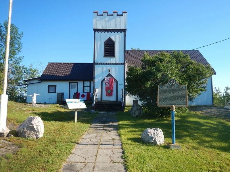
The original claim to the Bruce Mine location was filed in September, 1846 by James Cuthbertson. It was acquired the following year by the Montreal Mining Company, and production commenced in 1847-48 at what became the first commercially successful . . . — — Map (db m105635) HM
A Maine-born promoter, Clergue transformed Sault Ste. Marie into a major industrial centre. He purchased an unfinished hydroelectric station and canal at the Sault in 1894; then, lacking markets for his electric power, he created his own . . . — — Map (db m106374) HM
Explorer, interpreter, fur trader and diplomat, French-born Perrot played an important role in the establishment and protection of New France's western frontier during the last four decades of the 17th century. In 1671 he was with Saint-Lusson at . . . — — Map (db m105957) HM
In recognition And In Tribute To The Men and Women Of The Mining Industry Who Developed The Gold Mines, And Our Community To What It Is Today. — — Map (db m218198) HM
Wawa's first town historian was Mrs. Agnes Turcott. Born Agnes Lindgren in Goren, Missouri in 1909, she spent her youth on the family homestead at Biggar, Saskatchewan. At the age of 18 she was a pioneer teacher earning $400 a year. Her marriage . . . — — Map (db m218197) HM
Born in Sault Ste. Marie, Ontario in August, 1907, Joseph Ernest Aime Breton was raised in a large family whose parents were involved in the hotel industry. Aime loved the wilderness and people. He could run a hotel just as easily as he could trap, . . . — — Map (db m218502) HM
Born in Cape Breton, Nova Scotia, Alex Ross was attracted to the Michipicoten area with hundreds of other fortune seekers after the cry of gold echoed through the hills in 1897. Alex first worked as a cook at the Minto Mine in 1898. Never one to . . . — — Map (db m218193) HM
Born in Sault Ste. Marie in 1929, Atillio (Tillio) was the oldest of 8 children of Reno and Pauline Berdusco. The family first settled at the Parkhill Mine where Reno worked as a gold miner and Pauline operated a dry goods store. When the gold . . . — — Map (db m218298) HM
Born in 1907, Al Turcott came to Wawa in 1939 with the idea that he would be employed for 6 months assisting with the construction of the crushing plant at the New Helen Mine. Deeply attracted to the area, Al soon sent for his wife Agnes and two . . . — — Map (db m218196) HM
[English] This highway's construction from St. John's to Victoria between 1949 and 1970 was a great feat of engineering, linking the provinces of this vast country. Here, in 1960, near the halfway point of the 7,821 kilometre-long . . . — — Map (db m199454) HM
Francis Hector Clergue was the visionary who recognized that Wawa's resource rich wilderness was the fuel to feed an industrial empire in Sault Ste. Marie. Born in Brewer, Maine in 1856, Clergue was a dynamic man with boundless energy, . . . — — Map (db m218375) HM
Joe Ball is one of Wawa's more colourful pioneers. Born in Michigan in 1864, Joe was one of many prospectors who found himself attracted to the lure of gold in the rugged hills around Wawa at the end of the 19th century. Joe worked as a caretaker . . . — — Map (db m218192) HM
Born in Saginaw, Michigan in 1920, Keith earned his private pilot’s license at the age of 20. He joined the U.S. Navy during World War II and was first stationed in Alaska. He flew OS2U Kingfishers and learned the hard way what the brutal Northern . . . — — Map (db m218191) HM
Lady Dunn was born Marcia Anastasia Christoforides in Sutton, England in 1909. During the Second World War, Marcia became the personal secretary for Sir James Dunn, a wealthy Canadian financier who was responsible for the rebirth and development of . . . — — Map (db m218190) HM
Louise Towab and her husband William Teddy are memorialized in Wawa's history books as discovering gold on Wawa Lake and forever changing the rugged landscape of this corner of Lake Superior country. Born in 1857, Louise represents the virtually . . . — — Map (db m218194) HM
Mention Northern Ontario diamonds, log cabins or the Wawa Goose and the name Mickey Clement will quickly follow. Clifford Claude "Mickey" Clement was born with the prospecting bug. He learned the rules and tools of the trade while panning and . . . — — Map (db m218299) HM
Mountains of Minerals The town of Wawa is surrounded by some of the world's oldest rock. These ancient Precambrian mountains were formed some 2.7 billion years ago. Within these mountains is a melting pot of minerals that have . . . — — Map (db m218199) HM
The Joy Super Heavyweight Champion Rotary Blast Hole Drill was utilized by Algoma Ore Division first at the Sir James Open Pit Mine which operated from 1958-1967 and later at the Lucy Open Pit Operation from 1967 to 1970. More than 8,500,000 gross . . . — — Map (db m218300) HM
Rod Morrison Sr. and the Algoma Ore Athey Wagon go hand in hand. Roderick F. Morrison was born in the Muskokas in 1917. He followed his brother Neil to work in the gold mines of Matechewan in 1936. In 1940 the newly constructed Sinter . . . — — Map (db m218399) HM
Sir James Dunn was a major Canadian business icon who was instrumental in the rebirth and growth of Wawa and Sault Ste. Marie in the first half of the 20th century. James Hamet Dunn was born in Bathhurst, New Brunswick in 1874. He was an articulate . . . — — Map (db m218195) HM
The famous Wawa Goose gazes out over the Trans-Canada Highway as it carries traffic through the Magpie River Valley. Some sections of this roadway follow old native trails and wagon paths leading from Lake Superior, along the Magpie River to the . . . — — Map (db m218328) HM
The nearby Michipicoten River formed an important link in the canoe route from Lake Superior to James Bay via the Michipicoten, Missinaibi and Moose Rivers. The route was probably explored at an early date by the French Fur traders who maintained a . . . — — Map (db m199496) HM
For Wawa residents, the name Surluga instantly conjures images of an overgrown gravel road, abandoned headframes rusted mining equipment and forgotten ghost towns. Tom Surluga was born in Krizisce, Croatia in 1907. As a teenager he found himself . . . — — Map (db m218397) HM
Wawa is just one of those place names that stands out. It is one of those names you will never forget. Where did this town get such a unique name and what does it mean? Ojibway Country When the first Europeans traveled to the Wawa . . . — — Map (db m218200) HM
Gold and Iron! What more could a mining town possibly want? The cry of "GOLD" in 1897 transformed the quiet fur trading country of Michipicoten into a bustling miniature Klondike. The Michipicoten Ojibway couple of Louise Towab and William Teddy . . . — — Map (db m218400) HM
Wawa's economy is based on our abundance of natural resources. Fur, fish, iron, gold, water and trees. The jumble of logs found at the base of Scenic High Falls are the remnants of Wawa's important logging history. Wood was first harvested along . . . — — Map (db m218600) HM
William Teddy was an Ojibway/Cree native Canadian born in 1855 in the Missinabie/Moose River region of Northern Ontario. Records show that William worked as a native guide for tourists, recreational fishermen and prospectors travelling thru the . . . — — Map (db m218189) HM
The weekly arrival of Captain Batten and the S.S. Caribou at Government Dock Beach at the mouth of the Michipicoten River was the highlight of early residents during the shipping season. Launched from her home port of Owen Sound in July 1904, the . . . — — Map (db m218556) HM
This beach received men & supplies for construction of the Canadian Pacific Railway in the 1880’s. In 1910 the Dominion Government & C.P.R. built a wharf and warehouse which were destroyed in the 1960’s. — — Map (db m218487) HM
The life and legacy of Louisa MacKenzie represents the important role of women in Canada's early frontier and the evolution of the fur trade industry. Louisa was the daughter of Honourable Roderick Mackenzie and a Chipewyan woman. Louisa was born . . . — — Map (db m218188) HM
From this high bluff, on a clear northern day, you can see the vast expanse of Lake Superior and the dramatic coastline of Michipicoten Bay. This is one of the only accessible lookouts with a fantastic view of pristine Lake Superior, mysterious . . . — — Map (db m218668) HM
Michipicoten can be found on some of the earliest European maps created by early explorers of North America. One of the first official cartographers to put Michipicoten on the map was the English surveyor Philip Turnor. Born in the English . . . — — Map (db m218634) HM
Welcome to the centre of Canada's dynamic fur trade history for nearly 200 years. The Michipicoten First Nation's introduced the first European explorers to the rich fur-bearing forests of their home in the 1600's. Michipicoten was the ideal . . . — — Map (db m218187) HM
This house was built in 1831 by Hiram Capron, a
native of Vermont who, in 1822, had emigrated to Norfolk
County where he helped to establish one of Upper Canada's
earliest iron foundries. He settled here at the Forks of the Grand in 1829, . . . — — Map (db m223280) HM
In 1877 this house, then located in downtown Brantford,
became Canada's first telephone business office. It was
the residence of the Reverend Thomas Philip Henderson
(1816-1887), a former Baptist minister and school
inspector in Paris, . . . — — Map (db m230401) HM
Royal Victoria Place, originally known as the Commercial Buildings, was designed by John Turner and built in 1881 by Bernhard Heyd. One of the first occupants was the Royal Loan and Savings Company. Following a devastating fire in 1988, . . . — — Map (db m215851) HM
The Bell Homestead
Here at his parents' home in July 1874, Alexander Graham
Bell conceived the fundamental idea of the telephone and, in August 1876, carried out the first successful long-distance trials. The Homestead evokes the . . . — — Map (db m230331) HM
In the 1820's significant improvements to the Hamilton and London road attracted settlers to the Indian lands at Brant's Ford where this thoroughfare crossed the Grand River. A thriving village soon developed and in 1830 the Six Nations surrendered . . . — — Map (db m199047) HM
[English] A leading spokesman for Canadian agrarian and co-operative movements, Good was born and raised on Myrtleville farm. He early developed a strong sense of social responsibility and, returning here after attending the . . . — — Map (db m217700) HM
In 1852, shortly after this region was opened for settlement, the government reserved land for a town here on the Elora and Saugeen Road, at the confluence of the Teeswater and Saugeen Rivers. Already settled on the site were Simon Orchard and . . . — — Map (db m198319) HM
This area was once covered in a thick, growth of trees including black walnut, maple, beech, elm and white oak. To make use of these natural resources, Josiah Henson and his sons used donations from benefactors in Boston to build a . . . — — Map (db m78402) HM
[English] For centuries the site of Cochrane was used by indigenous peoples as a summer camping ground. Later it became a stopping place for fur traders en route to Moose Factory. In 1907 the Temiskaming and Northern Ontario Railway . . . — — Map (db m217898) HM
[English] A Hudson's Bay Company post named after a son of George III, Frederick House was established in 1785 to prevent Canadian fur traders in the Abitibi region from intercepting the passage of furs to Moose Fort (Moose Factory) . . . — — Map (db m217973) HM
[English] This region's first inhabitants were aboriginal peoples who were attracted by its abundant natural resources and extensive water routes. Europeans arrived in the late 1600s to acquire furs and establish trade with the . . . — — Map (db m217890) HM
The chute was a narrow, fast water part of the Black River located approximately 1.0 km above the highway 101 bridge. It was here that the MacDougall family and their friends set up an encampment during their journeys through the area. The chute . . . — — Map (db m244991) HM
[English] From the 1880s onwards, as railways opened up northern Ontario, prospecting activity in this region intensified. The Porcupine gold rush began in 1909 following three significant discoveries. Thousands of prospectors and . . . — — Map (db m217899) HM
[English] There is no shortage of stories about the prospectors who came north during the Porcupine Gold Rush of 1909. Life was not easy; they carried 75-pound packs through muskeg and uneven ground. Of course nothing was certain . . . — — Map (db m199240) HM
[English] Timmins is one of the richest gold producing areas in the world; the Porcupine Gold Rush led to the extraction of well over 65 million ounces of gold to date and by comparison, the Klondike Gold Rush coaxed out just over 5 . . . — — Map (db m244434) HM
[English] After the Cariboo and Klondike rushes, gold production in Canada entered a new era with the discovery of lode deposits in the Porcupine area in 1909. The mines in this district, notably the Hollinger which became one of . . . — — Map (db m199247) HM
[English] "Great Rush of men to the Porcupine!" "On to the Porcupine is now the Cry!" Prospectors and speculators came from across the continent to take part in the Porcupine Gold Rush that began in earnest in 1909 with the . . . — — Map (db m244343) HM
[English] Once the ore is mined from the earth, the gold must be removed from the ore. The extraction of gold from ore and refining it into 'pure' gold involves a number of physical and chemical processes that are carried out on an . . . — — Map (db m244417) HM
Erected by the Timmins-Porcupine Chamber of Commerce in June, 1966 to commemorate development of this important zinc, copper, lead, silver discovery (time capsule in base) ————— Celebrating 50 Years of World Class Mining and Metallurgy (2016) Kidd . . . — — Map (db m244446) HM
Between 1801 and 1807 a settlement developed here in Pickering Township where the Danforth Road crossed Duffin's Creek. Among the early settlers was Timothy Rogers, a prominent Quaker and colonizer who built a saw and grist-mill in 1809. A . . . — — Map (db m208413) HM
On this site in 1866 Samuel Wilmot began to experiment with the artificial breeding of salmon. His success led the federal government in 1868 to enlarge Wilmot’s project into Ontario's first full scale fish hatchery, one of the earliest in North . . . — — Map (db m244767) HM
Robert McLaughlin, a pioneer of the Canadian vehicle industry, was born in the family homestead on this property. In 1867, despite lack of technical training, he built two cutters in his driving-shed which stood near this site. His business . . . — — Map (db m244813) HM
Established in 1869 as a home site, it was then used as a hotel from 1879 to 1897. Albert Cook expanded the building and opened the general store in 1898. Herb Harrison was the proprietor from 1919 to 1949. The store was, and still is, . . . — — Map (db m243793) HM
Born in nearby Enniskillen, McLaughlin apprenticed in his father's Oshawa carriage works when he was sixteen. Convinced of the potential for growth of the automobile industry, he established in 1907 the McLaughlin Motor Car Company, the first major . . . — — Map (db m198928) HM
[English] A famous industrialist and philanthropist, “Colonel Sam” McLaughlin was a founder of the automotive industry in Canada. Involved in the design and manufacture of carriages and sleighs for his family business, he foresaw . . . — — Map (db m208898) HM
The evolution of Oshawa’s automobile industry is depicted in this mural. In 1899, the McLaughlin Carriage Factory was destroyed by fire, but rebuilt within one year. The McLaughlin Motor Car Company, founded in 1907, began producing automobiles an . . . — — Map (db m227889) HM
This montage presents images of Oshawa’s development including the historic Sydenham Harbour, and the Oshawa Carriage Works, the factory operated by the McLaughlin Carriage Company, forerunner of General Motors of Canada. Also depicted are a 1924 . . . — — Map (db m227891) HM
This mural was sponsored by General Motors of Canada. The first panel illustrates members of the McLaughlin family, founders of the McLaughlin Carriage Company and McLaughlin Motor Car Company, forerunner of General Motors of Canada. Other panels . . . — — Map (db m227775) HM
This mural portrays Oshawa’s development with the slogan “Building on a Strong Foundation.” Listed at the top are early companies from Oshawa’s past. The panels below depict scenes from three influential companies — Warren Mills, Williams Piano . . . — — Map (db m227773) HM
The Argyle was a passenger and freight steamer that docked at Sydenham Harbour in the early 1900’s. It operated between Toronto and Cobourg with stops in Whitby, Oshawa and Bowmanville. The return fare from Oshawa to Toronto was $1.00. Evening . . . — — Map (db m227898) HM
The office for the Commissariat Department was built in 1831 near the government wharf and storehouse. Commissary officials purchased from local contractors the flour, beef, straw and firewood used by troops. They also managed Fort Malden's . . . — — Map (db m37356) HM
Massachusetts born, Hiram Walker had by the 1850s become a successful general merchant, distiller and grain dealer in Detroit. After Michigan adopted prohibition in 1855 he acquired land across the river in Canada where he established a distillery . . . — — Map (db m37377) HM
The Detroit River is unique in Canada, the United States and indeed, the world. Its shores embrace the largest metropolitan area on any international border - but rather than separating communities, the river connects them culturally and . . . — — Map (db m37378) HM
English:
This Kingston lawyer was the chief architect of Confederation, which led to the creation of the Dominion of Canada on July 1st, 1867. He was Canada's first Prime Minister and led the country for almost 19 years. The . . . — — Map (db m140200) HM
In 1811 Matthew W. Smith located the site for a flour
and saw mill here on the Dunnville Road, south of
the village of Canborough. The mill was constructed
later that year by Major Robinson and operated first
by horses and then by water . . . — — Map (db m235440) HM
This was the site of a flour and grist mill that served the village of York and district for almost a century. The original mill built in the 1820's or 1830's had a
water-wheel operated by water from the Grand River Navigation Co. dam at York. . . . — — Map (db m234917) HM
The intersection of Plains Road, Waterdown Road and Lasalle Park Road has always been a hub of activity and enterprise. The area surrounding these corners is rich in history and fabled for its market gardens. The settlement of Burlington Plains was . . . — — Map (db m243820) HM
The oldest commercial buildings date mostly from the 1846-57 period, when Oakville grew from a village of 500 to a newly-incorporated town of 2,000.
Development of Old Oakville's commercial district started at Sixteen Mile Creek and grew east . . . — — Map (db m238571) HM
Oakvilles churches, schools and taverns knit the community together and created a social support network.
Taverns and inns were usually the first public buildings in Upper Canadian towns. They doubled as town halls, churches and courthouses. . . . — — Map (db m238672) HM
The founder of Oakville was born in Nova Scotia of
Loyalist parents who moved to Burlington Bay in 1793.
William served with distinction in the militia during the
War of 1812. He settled in Nelson Township in 1816 and
became a successful . . . — — Map (db m237075) HM
William Chisholm’s first priorities for Oakville’s economic development were developing the harbour, building a grist and sawmill, and setting up a shipyard.
This activity, along with the declaration of the harbour as a Port of Entry for . . . — — Map (db m238303) HM
Oakville Heritage Trails
Old Oakville Loop
Early Leaders
In addition to the founder William Chisholm, strong
leadership from other citizens was important in developing
Oakville into a town by 1857. One such person was Merrick . . . — — Map (db m237951) HM
Water power from the Sixteen enabled the first industries to be established in Oakville.
The first sawmill on the Sixteen was built near Upper Middle Road around 1810. William Chisholm built the first gristmill near the Speers Road bridge in 1833. . . . — — Map (db m242238) HM
In Oakville, as in most of the area villages, the first public building to be erected was the tavern. Necessary way-stations in a land of arduous travel, taverns also provided meeting places for the new settlers to conduct business and enjoy . . . — — Map (db m241808) HM
Oakville’s early businessmen realized their success depended on the prosperity and attractiveness of the larger community. Many of them made civic affairs their business. Parks, sidewalks, road improvements, street lighting, public health and safety . . . — — Map (db m241701) HM
Tannery Park
Life "Over the Creek"
West Harbors history as a working class neighborhood began in the 1830s with William Chisholm's need to raise money for his ill-fated Oakville Hydraulic Company, which was to construct a dam on the . . . — — Map (db m237434) HM
Industry prospered in Oakville during the 1840s to 1860s, with the establishment of foundries, tanneries and carriage works.
In 1851 machinists John Doty and Ashley Hibberd built a foundry to manufacture sawmill equipment and steam engines. . . . — — Map (db m242252) HM
The early settlers of Oakville, while full of optimism lacked formal training- there were few master builders or architects at the time. In fact, the shipbuilders who came to work for Chisholm in the shipyard also built many of the first houses . . . — — Map (db m238338) HM
An Act to incorporate the Town of Oakville was assented to on May 27th, 1857. The first council members were:
Mayor G.K. Chisholm Farmer & Landowner
Ward 1 R.K. Chisholm Customs Agent & Postmaster
W.E. Hagaman General Merchant
Ward . . . — — Map (db m238339) HM
The manufacture of baskets, Oakville's longest lived industry, grew out of the area's flourishing fruit industry.
Pioneer strawberry grower John Cross manufactured the first wooden berry baskets of his own design in the 1860s. John A. . . . — — Map (db m242253) HM
During the 1830s, Oakville entered a prosperous era. Shipments of wheat and lumber made the harbour a busy focus of commercial activity. Steamships and stagecoaches carried passengers, mail and freight to and from Hamilton and York.
William . . . — — Map (db m238668) HM
Oakville Heritage Trails
Tannery Park
Few enterprises influenced the lives of ordinary Oakville
residents like the Marlatt & Armstrong Leather Co. did at the turn of the 20th Century. If you didn't work for the tannery, you smelled its . . . — — Map (db m237297) HM
Once, everyone from farmers to dowagers met and mingled on "Main Street." People knew all the merchants by their first names. Today, the friendliness remains, as well as much of the small-town charm, as Downtown Oakville develops its own blend of . . . — — Map (db m242154) HM
The first town survey was completed in 1833, enclosing an area bounded on the west by Brock Street, on the north by Rebecca and Randall Streets, and on the east by Allan Street.
Road allowances were laid out in the standard grid pattern . . . — — Map (db m238336) HM
Oakville Heritage Trails
Tannery Park
Oakville founder William Chisholm's 1827 grant of land included about 300 acres of land west of Sixteen Mile Creek. By buying a parcel owned by James and Susannah Brock, he was able to extend the . . . — — Map (db m237941) HM
Politician, businessman, land speculator and soldier, Allan MacNab enjoyed a very public life. He was a successful lawyer and was appointed Upper Canada's first Queen's Counsel. In 1838 he was knighted for his role in suppressing the rebellion in . . . — — Map (db m66130) HM
[English] The former Customs House (1858-1860) is a fine example of the Italianate style of architecture which was popular in Canada from the 1840s through the 1870s. Inspired by Renaissance palazzi of Rome and Florence, Italianate buildings . . . — — Map (db m196259) HM
European settlement began here
in 1792 with William Davis (1741-1834),
a United Empire Loyalist
who left North Carolina to fight
alongside the British in the
American Revolution. Davis was
granted 2300 acres in Barton and
Saltfleet . . . — — Map (db m228834) HM
This milling stone is all that remains of Albion Mills.
The first mill, built about 1795 by Wm. Davis, contributed
to the area's economic development. Settlers came and
the land was cleared. Many of their early homes are
within a short . . . — — Map (db m228965) HM
In 1791 James Wilson in partnership with Richard Beasley built a sawmill and a grist-mill on the site of this community. The mills were sold to Jean Baptiste Rousseaux (known as St. John) in 1794 and developed into a thriving pioneer enterprise. . . . — — Map (db m220193) HM
Sir John Morison Gibson
1842-1929
Lawyer, politician, and businessman, John Gibson was a tireless proponent of the economic advancement of Hamilton. Gibson's Hamilton-focused business interests
encompassed real estate development, . . . — — Map (db m227476) HM
William Terryberry
(1779-1847)
Since 1812, the name William Tenybeny has been associated with this section of Mohawk Road West. Having immigrated to the province of Upper Canada from the state of New Jersey, Terryberry purchased land along . . . — — Map (db m232325) HM
By 1799 the Morden family had a sawmill near this site
on Spencer Creek north of Dundas Street. They sold this
property in 1800 to Edward Peer who built a grist-mill
about 300 yards south-east, close to Dundas Street, and
adopted the name . . . — — Map (db m220819) HM
Peter Desjardins made it his life's work to develop viable canal route from Lake Ontario to Dundas
Desjardins came to Canada from France in 1792. He settled in Dundas in 1805 where he became Richard Hatt's chief clerk, Hatt envisioned a . . . — — Map (db m226479) HM
The province's first paper mill began operations in 1826.
Situated about 150 yards downstream from here, it was owned by James Crooks (1778-1860), one of Upper Canada's most successful entrepreneurs. On four hundred acres of land purchased here . . . — — Map (db m223079) HM
In the early 1800s, city promoters campaigned vigorously to bring a railway to Hamilton. In 1849, local industry and municipal government backed the construction of the Great Western Railway (GWR).
The first train left Hamilton on November . . . — — Map (db m235062) HM
414 entries matched your criteria. The first 100 are listed above. Next 100 ⊳