The temperate rain forest is dominated by Sitka spruce. Except where it penetrates valley such as the Hoh, the Sitka spruce grows along a narrow coastal strip from northern California to Alaska.
High rainfall, fog, and ocean-moderated . . . — — Map (db m83654) HM
The Spanish Captain Juan Perez sailed north from San Blas in 1774 with orders from Spain to claim the Coast against the Russians. Perez discovered Nootka Sound on the West shore of Vancouver Island and traded with the natives of the Queen . . . — — Map (db m83652) HM
The landscape of the Strait of Juan de Fuca was
carved out by ice-age glaciers 13,000 years ago.
The retreat of the glaciers created deep fjords which
provide abundant food and habitat for many species
of marine mammals.
By the mid-1900’s, . . . — — Map (db m83693) HM
Raging Ice Age floodwaters carved spectacular features throughout eastern Washington, creating unique landscapes. Follow the path of the floods and discover more about this amazing story.
Path of Least Resistance
As floodwaters rushed . . . — — Map (db m83044)
You are standing in the pathway of some of the largest floods ever known. They carved steep-walled canyons, sculpted immense waterfalls, and left behind landscapes found nowhere else on earth.
Massive Glacial Dams and Lakes
During the . . . — — Map (db m83019)
Long before the Ice Age floods could carve the coulees, waterfalls, and cliffs that dominate this landscape, basalt was needed, and in huge quantities! Vents from deep in the earth’s crust supplied the basalt, erupting again and again to cover much . . . — — Map (db m83023)
Welcome to Palouse Falls, Washington's official state waterfall. Behind this designation by the state legislature is a story of how local students with a vision created state law - and made state history.
Waterfall Facts Palouse Falls is . . . — — Map (db m129494) HM
Before the Ice Age floods, no stream or waterfall existed here. Instead, the Palouse River flowed through Washtucna Coulee. What caused the river to jump its course?
When the floods surged across the area, they cut a path through the fractured . . . — — Map (db m83021)
Flood waters, perhaps 300 feet above you, once rushed over these cliffs. During the ice age, glaciers to the north blocked the Columbia River and forced it to find a new route. The river, swollen from melting glacial ice, began to carve a new . . . — — Map (db m129678) HM
Raging Ice Age floodwaters carved spectacular features throughout eastern Washington, creating unique landscapes. Follow the path of the floods and discover more about this amazing story.
Gouging Deep Coulees The powerful floods cut . . . — — Map (db m129681) HM
You are standing in the pathway of some of the largest floods ever known. They carved steep-walled canyons, sculpted immense waterfalls, and left behind landscapes found nowhere else on earth.
Massive Glacial Dams and Lakes During the last . . . — — Map (db m129680) HM
These cliffs are skeletal remnants of what was once the world’s largest waterfall. They bear stark witness to the tremendous power of catastrophic floods that swept over Eastern Washington at the end of the last Ice Age.
The falls began 20 mi. to . . . — — Map (db m129677) HM
The sheer cliff in front of you was once the world's greatest waterfall. From here, you see only the western portion of this remarkable Ice Age floods feature. With the end of the last Ice Age, floodwaters no longer swept through Grand Coulee, . . . — — Map (db m129679) HM
Fiery Floods
Twenty-five million years ago, this area was a land of meandering streams and lush, rolling hills. Then came the first lave flow. Long cracks or vents opened in the earth and lava flooded the land spreading like water. The . . . — — Map (db m38486) HM
Imagine standing here millions of years ago on the edge of a huge plain fringed by distant mountains. Cypress trees grow in the swamps. Maple, sycamore, ginkgo, sequoia, and fir cover the nearby hills and mountains. Ancestors of rhinoceroses and . . . — — Map (db m38446) HM
Millions of years ago, some of the largest lava flows on earth poured over this area again and again. Enormous floods of molten lava flowed out from long, parallel vents, burying the area in more than 5,000 feet of basalt.
In all, more than 300 . . . — — Map (db m82825)
When Ice Age floodwaters rushed across Quincy Basin and down the Columbia River, they gouged chunks of basalt from the scabland cliffs in front of you. During the last Ice Age, this area was repeatedly swept by floodwaters that tore away layer after . . . — — Map (db m82829)
Raging Ice Age floodwaters carved spectacular features throughout eastern Washington, creating unique landscapes. Follow the path of the floods and discover more about this amazing story.
Under Water
During the largest floods, water . . . — — Map (db m82827)
After racing across eastern Washington, floodwaters converged on Wallula Gap, a single narrow outlet about 80 miles to the southeast. This natural constriction forced floodwaters to back up, creating a huge, temporary lake called Lake Lewis. Here at . . . — — Map (db m82830)
You are standing in the pathway of some of the largest floods ever known. They carved steep-walled canyons, sculpted immense waterfalls, and left behind landscapes found nowhere else on earth.
Massive Glacial Dams and Lakes
During the . . . — — Map (db m82826)
Geologists say between 13,000 and 15,000 years ago a series of huge catastrophic floods scoured this landscape. Surging water and large pieces of ice ripped rock, sediment, and soil from everything that surrounds you. Horsethief Butte withstood the . . . — — Map (db m158359) HM
A Great Place to Live
Floods of lava and water formed the unique landscape of the Columbia River Gorge. Nearby, rock formations and sandy soils created a perfect site for a village. In the low land beyond this small plateau, . . . — — Map (db m158326) HM
Geologist say that about fifteen million years ago, molten stone poured from cracks in the earth near the eastern border of today's Washington and Oregon. Layers of flowing lava spread west, coating 65,000 square miles with andesite and basalt up to . . . — — Map (db m158322) HM
Gray clouds, heavy with moisture from an absorbent journey across the ocean, drizzle inland from west to east. Bumping into the Cascade Mountains, the rise, cool, and drop a final deluge that soaks the fir forests on the west facing slopes. . . . — — Map (db m158320) HM
The rock before you is a clue to a geologic mystery. Between 110,000 and 20,000 years ago, a volcano erupted about nine miles away. Dacite lava flowed here and stopped, forming an unusually deep pool. Geologists don’t know for sure what blocked the . . . — — Map (db m71658)
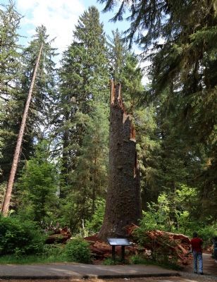
Enter an ancient forest and find yourself sheltered by giant trees reaching more than 200 feet into the sky. Western hemlock and western red-cedar, some as old as 850 years, are the dominant trees in Mount Rainier’s old-growth lowland forests. These . . . — — Map (db m62156) HM
Mud on the Move. Along with lava and ash, the
volcanically active Mount Rainier has contributed thick flows of mud from its sides and summit. One of the largest mudflows occurred about 5,800 years ago sending thick rivers of mud down the White . . . — — Map (db m84414) HM
Why is the River White? Particles the size and color of plaster
dust give the White River its distinctive
pale hue. These particles are what geologists call “glacial flour”—a fitting name for the pulverized rock from the . . . — — Map (db m84396) HM
Since the early 1900s people have parked at this site to get an exceptional view of Mount Rainier. The park road was designed to harmonize with the landscape and take advantage of spectacular vistas like this one.
The surrounding scenery . . . — — Map (db m70745) HM
Does this forest look different than the forest on the other side of the river? Multiple mudflows have raced down Mount Rainier’s slopes snapping off trees like toothpicks. When the mud stopped flowing, it set like concrete over tree roots, . . . — — Map (db m70743) HM
Not long ago, the waters of Kautz Creek filled this creek bed. Today only a small stream flows here. Kautz Creek has moved.
Along with record rainfall, early November 2006 brought debris flows to several areas of the park. Not far from here, . . . — — Map (db m70744) HM
Along this short trail, discover clues to one of the most powerful geologic forces that has shaped Mount Rainier.
Mudflows have thundered down this valley, topping trees, damaging bridges and leaving behind thick layers of mud and debris. . . . — — Map (db m70742)
Mount Adams. Mount Hood. Mount St. Helens. These serene, snow-covered mountains beckon one to come closer. But beware. These mountains were born by repeated, often violent eruptions of ash, lava, and pumice. Their eruptions and landslides created . . . — — Map (db m158995) HM
(two markers are mounted on this kiosk)
Master Traders
The Lewis and Clark Expedition first met Chinookan tribes as they traveled through the Columbia River Gorge in autumn 1805. At the time, Chinookan society . . . — — Map (db m158244) HM
If you are admiring the view upriver to Wind Mountain, you're in good company. Travelers throughout history have been awed by the grandeur of the steep cliffs and unique mountain formations of the Columbia River Gorge. Early journal entries from . . . — — Map (db m158238) HM
Grasses, flowers and other plants support the food web of prairies. Butterflies thrive on flower nectar and may use just one plant species to host their caterpillars. Bees pollinate the flowers. Ground-nesting birds hide their nests among the . . . — — Map (db m71781)
What Makes a Prairie
Grasslands thrive where dry soil and frequent drought or fires limit or exclude trees and shrubs. The soils and climate in each of North America’s grasslands support a unique mix of native grasses, flowers, and other . . . — — Map (db m71780)
More than 30 explanation have been proposed for the origin of the Mima Mounds, but none has been proven.
Were the Mounds Created by Glacial Ice?
In 1913 glacial geologist J Harlan Bretz completed the first detailed study of the Mima . . . — — Map (db m71779)
The Mima Mounds were formed some time after ice age glaciers began receding 16,500 years ago. Their origin has puzzled scientists and curious visitors since the mid-1800s. Research has revealed what we know so far about the glacial history of this . . . — — Map (db m71778)
Kloochman Rock is a volcanic "intrusion" composed of what is called a "pyroxene-rich andesite." Intrusions are created when molten volcanic material is pushed up into a fissure or crack where it cools and hardens. Andesite is a relatively hard fine . . . — — Map (db m71522)