On Fermanagh Street just north of Monaghan Street (National Road 54), on the right when traveling south.
These features were part of a monastery founded by St Tighearnach at the beginning of the 6th century. The 10th or 11th century Round Tower, the monastery's bell-tower, is the oldest surviving building on the site. Close by, in the graveyard, is . . . — — Map (db m72654) HM
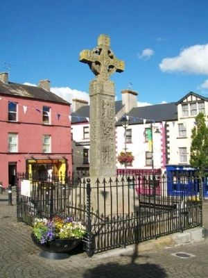
On Fermanagh Street just north of Monaghan Street (National Road 54), on the right when traveling south.
This is a 10th century Ulster Scripture Cross. Cap-stone, Head & Shaft are all from different periods. However, the main shaft is dated as above. Originally a termon or boundary cross marking monastic lands limit.
Also used as a teaching aid . . . — — Map (db m73258) HM
Here lie the remains of
St Tiernach.
Of the Royal House of Oriel.
First Abbot of Clones Monastry [sic]
Bishop of Clogher.
500 AD to 4th April 548. — — Map (db m73277) HM
On Ball Alley just west of McCurtain Street (R212), on the left when traveling west.
One of the earliest examples of a round Tower. Probably built in the 10th century. The base shows evidence of attempts to destroy by burning.
The Tower lost its conical cap between 1591 and 1741. Four top windows face the cardinal points. Old . . . — — Map (db m73266) HM
On Ball Alley just west of McCurtain Street (R212), on the left when traveling west.
Twelfth century representation of an early Christian Church. Carved from a single block of sandstone. Originally made to contain a relic possibly of Saint Tiernach. Carving on surface severely weathered.
Position of Sarcophagus probably in . . . — — Map (db m73272) HM