Near Holdenville in Hughes County, Oklahoma — The American South (West South Central)
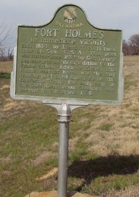
Fort Holmes
In immediate vicinity
Erected 1958 by Oklahoma Historical Society and State Highway Commission.
Topics and series. This historical marker is listed in these topic lists: Exploration • Forts and Castles • Industry & Commerce • Wars, US Indian. In addition, it is included in the Oklahoma Historical Society series list. A significant historical year for this entry is 1834.
Location. 35° 1.134′ N, 96° 22.065′ W. Marker is near Holdenville, Oklahoma, in Hughes County. Marker is on State Highway 48, 0.3 miles south of Old Highway 12 (County Route D138), on the right when traveling south. Marker is about 5 miles south of Holdenville just past Lake Holdenville. Marker is not in its original location so distances listed on marker are incorrect. It was placed at its new location when the new SR 48 was constructed. Touch for map. Marker is in this post office area: Holdenville OK 74848, United States of America. Touch for directions.
Other nearby markers. At least 5 other markers are within 14 miles of this marker, measured as the crow flies. Allen War Veterans Memorial (approx. 10.1 miles away); United States Armed Forces (approx. 11.9 miles away); Sasakwa (approx. 12.2 miles away); Osage Village (approx. 12.8 miles away); Chickasaw/Choctaw Stickball Game (approx. 13.9 miles away).
Credits. This page was last revised on June 16, 2016. It was originally submitted on April 2, 2013, by Michael Manning of Woodlawn, Tennessee. This page has been viewed 1,210 times since then and 120 times this year. Photo 1. submitted on April 2, 2013, by Michael Manning of Woodlawn, Tennessee. • Bernard Fisher was the editor who published this page.
Editor’s want-list for this marker. A photo of the marker and the surrounding area in context. • Can you help?
