On Main Street (County Highway 5) just east of Victoria Street, on the right when traveling east.
A tribute to the great
Canadians that came
from the British Isles to
Canada and lived off
the land. They worked
hard to clear the land,
built log homes and
raised their families.
All that is left to
remember them is the
little . . . — — Map (db m142020) HM
On Wellington Street East at Henry Street, on the left when traveling west on Wellington Street East.
No one in need, or ill, ever lacked care or attention if Aunt Sarah knew about it. In 1891, Aunt Sarah was a practical nurse, midwife and a devout Quaker who was loved by all. She brought babies into the world, tended the sick, comforted the . . . — — Map (db m203454) HM
On Main Street (County Highway 5/42) at Elgin Street (County Highway 5/40), on the left when traveling west on Main Street.
Farmersville was named by its founder, Joshua Bates to honour farmers as the foundation of the community. Bates was an entrepreneur, philanthropist, politician, and a progressive Reformer who believed that education, and hard work would . . . — — Map (db m141903) HM
On Henry Street at Wellington Street, on the left when traveling north on Henry Street.
This iconic Athens building opened in February 1860 as the Farmersville Public School. Primary grades occupied the first floor and in September the grammar (or high) school opened on the second floor. As the first high school in a wide area, . . . — — Map (db m142024) HM
On Main Street (County Highway 5) at Henry Street, on the left when traveling east on Main Street.
This Mural was created by artist, Pierre Hardy on the north wall of the H & R Feed & Pet Supplies building in 1988. In this mural, the action takes place in the lumberyard of the Hartley Saw Mill. It is springtime, the time of year when Farmers . . . — — Map (db m142021) HM
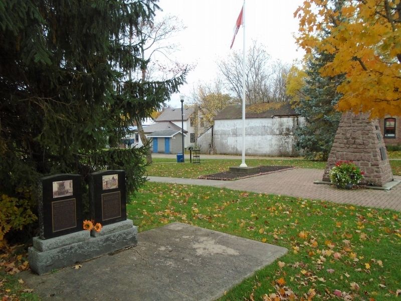
On Main Street (County Highway 5) just east of Victoria Street, on the right when traveling east.
A tribute to the little
immigrants ages 5 to 14 who
came from the Quarrier Homes
Scotland, and the Barnardo
Homes England, to the
Fairknowe Home in Brockville.
They were placed on hundred
acre farms and made to work
long hours at . . . — — Map (db m141961) HM
On Henry Street north of Wellington Street, on the left when traveling north.
Astonishingly, Myles Jeffrey never made a boat for himself. Myles gained his knowledge working for Gilbert's in Brockville, Pyke in Lachine, PQ, and Chris-Craft in Michigan, USA. But he preferred working at his own pace and to his own high . . . — — Map (db m142028) HM
On Elgin Street (County Highway 5) at Main Street (County Highway 5/42), on the right when traveling north on Elgin Street.
The son of United Empire Loyalists, Joshua Bates had a strong vision for the settlement which he named Farmersville. As an architect and surveyor, he donated the land and built the first schools and churches as well as erecting the first store, . . . — — Map (db m141941) HM
On Main Street (County Highway 5) just east of Victoria Street, on the right when traveling east.
This oak tree is a descendant from the few acorns gathered after the Battle of Vimy Ridge by Canadian soldier Lt. Leslie Miller. Not a single oak tree remained standing in the aftermath of the shelling. This tree, a descendant of one of . . . — — Map (db m141952) HM WM
On Main Street (County Highway 5) just east of Victoria Street, on the right when traveling east.
1914 • 1918
To the memory of
our boys who paid the
supreme sacrifice
in the Great War
Ross de Wolfe · Frank Whitford
J. Mills Johnston · Gerald Botsford
Basil Connerty · Lloyd Scott
Delos Spence · John Corr
Gordon Kelsey · . . . — — Map (db m141951) WM
On Block House Island Road, 0.2 kilometers south of Water Street, on the left when traveling south.
Muscallonge
GPS: 44° 36.246’ N. 75° 39.215' W.
The “Muscallonge” was a large wooden tugboat, measuring 39 m long by 7 m wide. This tug – later to be nicknamed the “Muskie” – was built in Port Huron, Michigan in 1896. In 1936, it . . . — — Map (db m141812) HM
On Block House Island Road just south of Water Street, on the right when traveling south.
This photograph, taken in 1896, is of particular interest because it documents buildings that no longer exist or that have been altered by the passage of time.
The grouping of buildings in the lower-left corner were standing on the . . . — — Map (db m141617) HM
Dedicated by the Citizens
of Brockville and 426 Wing
R.C.A.F.A. to the memory
of all Allied Airmen who
gave their lives to the
cause of freedom
June 23, 1968 — — Map (db m141690) WM
On Block House Island Road, 0.2 kilometers south of Water Street East, on the left when traveling south.
On this island, formerly known as Hospital Island, stood the sheds erected to house emigrants who were victims of cholera in the great epidemic of 1832. Many persons died here, including Doctor Robert Gilmour, a native of Scotland and president of . . . — — Map (db m87065) HM
On Block House Island Road, on the right when traveling south.
This piece of waterfront land has not been a real island since 1860, when it was joined to the mainland by the Brockville & Ottawa Railway. This early railway company established their new terminus on Blockhouse Island, in conjunction with the new . . . — — Map (db m141824) HM
On Block House Island Road, on the right when traveling south.
Although technically no longer an island, this park peninsula has traditionally been known by a number of names in our local history. The original REFUGE ISLAND, a bare rock with some scrub growth, became HOSPITAL ISLAND during its tenure as an . . . — — Map (db m141826) HM
On Block House Island Road, 0.1 kilometers south of Water Street, on the left when traveling south.
The original Brockville waterfront railway station and passenger depot for the Brockville & Ottawa Railway was located south of the Brockville Railway Tunnel, near to this area from 1860 to 1872. In 1872, a new Union Station was built . . . — — Map (db m141661) HM
On Water Street at Block House Island Road, on the right when traveling east on Water Street.
The Brockville Farmers' Market was first established here in 1833
The Legislative Assembly of Upper Canada, by an Act passed on December 18, 1832, authorized the establishment of a market in Brockville. The Act was signed into . . . — — Map (db m141676) HM
Regular ferry services linked Brockville to Morristown, N.Y., from the 1850s to the 1950s. Eventually, the opening of the Ogdensburg International Bridge and the Thousand Islands Bridge spelled the end of ferry services in . . . — — Map (db m141623) HM
On Court House Avenue (Provincial Highway 29) at George Street, on the left when traveling north on Court House Avenue.
In honour of all our men and women
who have answered the call to arms
in defence of our homeland
along with the
Brockville Infantry Company (1862)
and The Brockville Rifles (1866).
Unveiled by Mayor David Henderson,
July . . . — — Map (db m146965) HM WM
On Block House Island Road, on the right when traveling south.
On August 12, 1931, Tommy Marshall, Don Fraser, John Kinghorn, and others met to form a pipe band in Brockville. Marshall was chosen as Pipe Major of the new Brockville Highland Pipe Band.
In 1934, uniforms were purchased from R.G. . . . — — Map (db m141828) HM
On King Street West (County Highway 2) just west of Market Street, on the left when traveling west.
Commemorating
the continuous publication
of the
Brockville Recorder
for one hundred years
1821 — 1921—
Ontario's
Oldest Newspaper
Recording events of local,
national and world-wide
interest for . . . — — Map (db m146967) HM
On Ferry Street just south of Water Street, on the left when traveling south.
As Brockville's oldest social club, the Brockville Rowing Club was founded in 1894. The present building replaced the old one in 1978, to continue Brockville's successful rowing tradition.
Fondée en 1894, le club d'aviron de . . . — — Map (db m141618) HM
During one of the annual Rowing Regattas
held by the BROCKVILLE ROWING CLUB
Near the turn of the century, some of the most popular sporting and social events of the summer season in Brockville were the regatta races held by the BROCKVILLE . . . — — Map (db m141763) HM
On Water Street East east of Orchard Street, on the right when traveling east.
On the evening of September 18th, 1966, over one thousand local teenagers marched from this point to Browns Bay Provincial Park, a distance of eleven miles, with each teen being sponsored by one or more persons at the rate of ten cents for each . . . — — Map (db m193825) HM
This Flag Pole has been erected to commemorate the birthplace of the Canadian Maple Leaf Flag first raised on February 15, 1965.
The culmination of the efforts of many individuals spanning more than 100 years come to fruition when Prime . . . — — Map (db m193792) HM
On Water Street East east of Orchard Street, on the right when traveling east.
Canada's first underwater sculpture park was established in 2014 and dedicated to all those who tragically lost their lives in the St. Lawrence River. The first sculptures were part of the memorial circle that is the focal point of the underwater . . . — — Map (db m193826) HM
On Water Street West at Home Street, on the left when traveling west on Water Street West.
Brockville
Centennial Park
Erected by the City of Brockville
in permanent commemoration of the
Centennial of Confederation in
Canada in 1967. Construction was made
possible through the co-operation of
the Province of . . . — — Map (db m147115) HM
On Block House Island Road, 0.2 kilometers south of Water Street, on the right when traveling south.
Con Darling, Ambassador of Smiles,
dedicated his life to the
betterment of humanity.
This memorial pays tribute to
his love of community
both young and old.
May his memory and spirit of
giving life in us all.
This commemoration . . . — — Map (db m141816) HM
On Wall Street (Provincial Highway 29) at Pine Street, on the right when traveling north on Wall Street.
In September, 1843, the first bank in
Brockville
was opened on Court House Avenue by the
Bank of Montreal
This plaque commemorates that event
and was installed by the bank
to observe its 150th anniversary
in the Centennial . . . — — Map (db m146979) HM
On Court House Avenue (County Route 29) at William Street, on the right when traveling south on Court House Avenue.
Completed in 1886 this structure was designed under the direction of Thomas Fuller, Chief Architect of the Department of Public Works from 1881 to 1896. The Brockville Post Office shows the sensitivity often displayed by Fuller and his staff. The . . . — — Map (db m87064) HM
On the night of February 6-7, 1813, Major Benjamin Forsyth of the United States Army, with a detachment of regulars and militia numbering about 200 men, crossed the frozen St. Lawrence River from Morristown, N.Y., and attacked Brockville. The . . . — — Map (db m83482) HM
On King Street West (County Highway 2) at Court House Avenue (County Highway 29), on the left when traveling west on King Street West.
The Fulford Block, built 1887-89
This photograph shows how the Fulford Block
looked before a disastrous fire in July 1916
destroyed everything but the outside walls. — — Map (db m146959) HM
Built in 1899 – 1900, this eclectic mansion evokes the opulent lifestyle of Canada’s industrial elite at the turn of the century. Designed by American architect A. W. Fuller, it was the spacious residence of Senator George T. Fulford (1852–1905), . . . — — Map (db m87017) HM
On King Street (County Highway 2) just west of Bethune Street, on the right when traveling west.
On the left are two former hotels,
Garbutt's Hotel and the Hotel Manitonna.
The signs of Roode Bros., the Ford dealer,
show on the right. — — Map (db m141568) HM
On Court House Square close to Court House Avenue, on the left when traveling east.
Brockville was named after the Provisional Civi Administrator of Upper Canada and the Commanding Officier of the British forces in Upper Canada during the War of 1812-1814.
The government of Upper Canada first named this community . . . — — Map (db m83527) HM
Born at Brockville, Canada West, Chaffey became a shipbuilder on the Great Lakes and the inventor of a new type of propeller. Subsequently he went to California where, in partnership with his brother, he built a model irrigation project and founded . . . — — Map (db m87019) HM
On King Street West (County Highway 2) just west of Market Street, on the left when traveling west.
H. H. Cossitt & Bro.
Confectioners
c. 1895 - c. 1903
C. H. Buell & Son
Bakers and Confectioners
c. 1903 - 1918
John Tait
Baker and Confectioner
1919 - 1930 — — Map (db m146912) HM
On King Street West (County Highway 2) just west of John Street, on the left when traveling east.
The large Halladay Block was mostly destroyed
by the fire on November 27, 1949.
On the near corner was the gasoline station
and tire vulcanizing shop of Leroy Dickey. — — Map (db m147012) HM
On King Street West (County Highway 2) just east of John Street, on the right when traveling east.
On the right is the corner grocery store of James L. Greenwood.
It was located in the former Halladay Block, mostly destroyed
by the fire on November 27, 1949. — — Map (db m147013) HM
On King Street East (County Highway 2) just east of Murray Street, on the right when traveling east.
Residence From 1884 to 1905 of
Major James M. Walsh
Superintendent of The North-West Mounted Police
Major James Morrow Walsh was a Canadian hero and a figure of national prominence in the second half of the nineteenth . . . — — Map (db m147075) HM
On Broad Street just south of Flint Street, on the right when traveling south.
Founded in 1865, the James Hall & Co. Glove Works operated on this site until about 1917. By 1898, it was the largest company making gloves and mitts in Canada. Owned and operated by John MacLaren and later his cousin, William C. . . . — — Map (db m146944) HM
On William Street at Court House Square, on the left when traveling south on William Street.
A prominent Canadian politician, Morris was born in Paisley, Scotland. His family immigrated to Canada in 1801 and later settled in Elizabethtown (Brockville). He joined his brothers, Alexander and William, in business there about 1820 and by 1836 . . . — — Map (db m87063) HM
Aerial View of the
James Smart Manufacturing Co. Ltd.
ca. 1930
Across the harbour, in the present HARDY PARK, was a complex of buildings that occupied this area of the waterfront for almost 100 years. Founded by James . . . — — Map (db m141686) HM
On Court House Square close to John Ross Matheson Way.
In 1808 the provincial government authorized the erection of a court house and gaol in Elizabethtown (Brockville) to serve the District of Johnstown created ten years earlier. By 1811 a brick structure had been built here on land donated by William . . . — — Map (db m83480) HM
On Court House Square, on the left when traveling east.
Symbols of law and authority to a new and changing society, the district court houses of Upper Canada were architecturally prominent buildings in the colony. Of these, one of the most grandiose is the former Johnstown District court house which was . . . — — Map (db m87027) HM
On Court House Avenue (Provincial Highway 29) at George Street, on the left when traveling north on Court House Avenue.
Pictured hereon is the
1812 monument in St. Paul's Cathedral,
London, England with the following inscription:
Erected at the public expense
To the memory of
Major General
Sir Isaac Brock,
who gloriously fell
on . . . — — Map (db m146942) HM
On Water Street at Ferry Street, on the right when traveling east on Water Street.
Major James Morrow Walsh was a colourful figure who played an important role in opening the Canadian West. Born on May 22, 1840 in Prescott, Ontario, he became one of the first nine officers of the North West Mounted Police . . . — — Map (db m141663) HM
On King Street West (County Highway 2) at Broad Street, on the left when traveling west on King Street West.
This appears to be a May Day Parade, as the
young girls in white dresses who performed
each year on the Court House Green pass by. — — Map (db m146958) HM
The mouth of Buell’s Creek was the location of an early sawmill built by Daniel Jones Sr. in the 1790s. This was followed by the gristmill, built by Robert Shepherd in the 1850s (still existing to the north).
From the position, looking across . . . — — Map (db m146935) HM
On Parkedale Avenue just east of Stewart Boulevard (County Highway 29), on the left when traveling east.
This sculpture symbolizes the strength and confidence of our students entering the new millennium. With cooperation, creativity, and communication, accomplishments may only be bound by the limits of our own imagination. In this case the . . . — — Map (db m193795) HM
On Court House Square close to Court House Avenue, on the right when traveling east.
A prominent provincial politician, Gowan was born in County Wexford, Ireland. He came to Upper Canada in 1829 and immediately immersed himself in political affairs. Drawing upon his experience in the Irish Orange Order, Gowan established the Grand . . . — — Map (db m83479) HM
On King Street West (County Highway 2) at Market Street West, on the left when traveling east on King Street West.
In the middle of this picture are the former
Queen's Hotel (left) and Victoria Hall (right).
The latter, built in 1862-64, is now
Brockville's City Hall. — — Map (db m146962) HM
F-86 Fighter Jets: Designed by NORTH AMERICAN AVIATION Co.
Built in Montreal by CANADAIR
Canadian planes powered by the
AVRO CANADA Orenda engine
The ROYAL CANADIAN AIR FORCE created a new precision aerobatic team in 1959 to . . . — — Map (db m141679) HM WM
This river was named "Rivière de Saint Laurens"
by French explorers in honour of
Saint Lawrence, the Martyr
Laurentius or Lorenzo, Archdeacon of Rome
Executed in Rome, August 10, 258, by order of
Roman Emperor . . . — — Map (db m141693) HM
"Sally Grant" is the familiar name of the Statue of Justice which was conceived in 1841 by John G. Howard, the architect of this Court House, and carved by William Holmes, a Brockville carpenter and builder. The eleven foot high figure, made of . . . — — Map (db m87957) HM
287 entries matched your criteria. The first 100 are listed above. Next 100 ⊳