Originally conceived in 1818 by its promoter, William Hamilton Merritt, to divert trade from the Erie Canal and New York and built under private auspices, the canal was opened to traffic in 1829. After additional work in 1833, the canal with its 40 . . . — — Map (db m75850) HM
[Text on the West Side]:
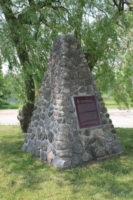
Battle of Chippawa
5 July 1814
In memory of all those who fought on this ground, many of whom are buried nearby,
and to commemorate the peace that has prevailed between Canada and the . . . — — Map (db m49393) HM
On these fields and the surrounding woods 4,000 American, British, Canadian and Native forces fought the first major battle of the Niagara campaign of 1814. When the last shots died away on Samuel Street's farm, more than 800 lay dead and wounded. . . . — — Map (db m49398) HM
At dawn 5 July 1814, parties of Canadian-Militia and British allied Native Warriors scouted the American camp. They began sniping from the bushes on the north side of Street's Creek and this continued throughout the morning. Around noon, General . . . — — Map (db m49399) HM
Major General Phineas Riall, the British commander, had repaired the bridge over the Chippawa and ordered his own Regular light infantry, the local Canadians of the 2nd Lincoln Militia and a force of Native Warriors, to clear out the now scattered . . . — — Map (db m49400) HM
British General Riall was convinced that the greater part of Brown's army was still surrounding Fort Erie. He did not know the Fort had surrendered and he was facing the entire U.S. division. Still, the number of men deployed on both sides was . . . — — Map (db m49402) HM
As the battle raged, more American artillery deployed to the middle of the plain between the 11th U.S. and the lone 25th U.S. company, less than 100 meters (109 yards) from the British line. General Brown then led Ripley's brigade across Street's . . . — — Map (db m49403) HM
The Aftermath. In the days following the battle, General Brown's victorious troops advanced another 25 kilometers (18 miles) north to Fort George before retiring back to Niagara Falls when more British troops arrived in the area. They met the . . . — — Map (db m49404) HM
A frame church was built here following the arrival in 1820 of an Anglican missionary, the Reverend William Leeming. It was burned on the night of September 12-13, 1839, by supporters of William Lyon Mackenzie who crossed the Niagara River from New . . . — — Map (db m78869) HM
The fortifications which stood on this site were built in 1791 to protect the southern terminus of the Niagara portage road, and serve as a forwarding depot for government supplies. Known also as Fort Welland, the main structure consisted of a log . . . — — Map (db m49164) HM
The British used Navy Island from 1761 to 1764 as a shipyard in which to build the first British decked vessels to sail the upper lakes. These were essential in maintaining the supply lines westward during Pontiac's uprising, 1763-4. Thereafter the . . . — — Map (db m49052) HM
Niagara's beauty has been an inspiration for today's environmental movement. Early conservationists such as George Catlin and Frederick Olmstead, who invented the concept of national parks, came to view its wonders. Nurtured by such visions and . . . — — Map (db m64652) HM
At daybreak on July 5, 1813, a British and Canadian force, consisting of some 35 militia and a small detachment of the 49th Regiment, embarked in this vicinity to attack Fort Schlosser. This American depot (now within Niagara Falls, New York) was . . . — — Map (db m49163) HM
Here, on 5 July 1814, an American army under Major-General Jacob Brown launched the last major invasion of Canada during the War of 1812. The Americans defeated a British and Canadian force commanded by Major-General Phineas Riall consisting of . . . — — Map (db m49050) HM
On this site was fought
The Battle of Chippawa
July 5, 1814.
Preservation of the Battleground
was made possible by
The Niagara Parks Commission
with the cooperation of
Frank and Mildred Branscombe,
River Realty . . . — — Map (db m49460) HM
On the night of December 29-30, 1837, some 60 volunteers acting on the orders of Col. Allen Napier MacNab, and commanded by Capt. Andrew Drew, R.N., set out from Chippawa in small boats to capture the American steamer "Caroline". That vessel, which . . . — — Map (db m64651) HM
In 1792-94 a village grew up near Fort Chippawa on Chippawa Creek at the end of the new portage road from Queenston. In 1793 the creek was renamed the Welland River, but the village, where a post-office was opened before 1801, remained "Chippawa". . . . — — Map (db m54124) HM
On the night of August 12, 1814 seventy seamen and marines, led by Captain Alexander T. Dobbs, R.N.,embarked in this vicinity to attempt the capture of three armed U.S. schooners lying off American-held Fort Erie. One of the six boats used had been . . . — — Map (db m53441) HM
Over the centuries there have been many ferry landings along the Niagara River. Some were built by local merchants and some as government licenced landing points.
The longest operating ferry dock was here, near the foot of present-day Bertie . . . — — Map (db m75876) HM
On the night of 12 August 1814, as a prelude to a British attack on Fort Erie, an expedition was mounted against three armed American schooners anchored off the fort. Captain Alexander Dobbs, R.N., embarked with 70 seamen and marines in six batteaux . . . — — Map (db m48913) HM
The border between Canada and the United States of America has witnessed many migrations of people. At two times, however, the migration was primarily from south to north. That was in the troubled days just prior to the American Revolutionary War . . . — — Map (db m75851) HM
Three fortifications occupied this site. The first (1764-1779) and second (c. 1783-1803), located at lower levels, were abandoned when ice and water inundated the works. The third Fort Erie, built between 1805 and 1808, was repaired in January 1814 . . . — — Map (db m48912) HM
Throughout the 1800s there were many ferry landings competing for business along the Niagara River. The map below is a compilation of some of these locations.
Ferry leases were granted to:
Col. John Warren Sr.,
John Warren Jr.,
Nelson . . . — — Map (db m75877) HM
[Text on the base of the Cairn];
Here are buried
150 British Officers and Men
Who fell in the attack on Fort Erie
On the 26th day of August, 1814, and three
of the defenders, men of the United States
Infantry, whose remains . . . — — Map (db m54139) HM
From around 1830 to 1860, thousands of freedom seekers used the Underground Railroad to reach sanctuary in Canada - the “promised land”. Many crossed the Niagara River from the United State to Fort Erie, including Josiah Henson and his . . . — — Map (db m75878) HM
In an effort to regain the initiative lost at Queenston, the Americans planned a general invasion for 28 November 1812. Before dawn advance parties crossed the Niagara River to cut communications between Fort Erie and Chippawa and to silence the . . . — — Map (db m49049) HM
A Loyalist from the Mohawk Valley, New York, Nelles came
to Canada during the American Revolution and from 1780 to
1784 served in the Indian Department. Following hostilities he settled near the Grand River but by 1792 had moved to this area. . . . — — Map (db m233660) HM
[English Text]: Engagement at the Forty
Here at the Forty Mile Creek, on 8th June, 1813, American forces, retreating after the Battle of Stoney Creek, were bombarded by a British flotilla under Sir James Lucas Yeo.
Indians and . . . — — Map (db m56704) HM
First Town Meeting
-1790-
Near this site on April 5. 1790, was held the
earliest known session of a municipal government
in what is now Ontario. This ‘town meeting' of
Township No. 6, later named Grimsby, dealt with
such matters as the . . . — — Map (db m233729) HM
Grimsby Nature
Fisheries in Grimsby
The fish once caught in Lake Ontario help tell the story of settlement and growth around Forty Mile Creek. The Neutral Confederacy, Niagara's first inhabitants, were well established in the area, . . . — — Map (db m234100) HM
We dedicate this flagpole to the
Grimsby 1812 Bicentennial peace garden
in honour of the "Encounter at the Forty"
at this site on June 8, 1813, a turning point in
the War of 1812 by the United States and the British.
Also, to celebrate 200 . . . — — Map (db m56993) HM
We dedicate this gazebo to the Grimsby 1812 Bicentennial Peace Garden and to the residents of Grimsby, In commemoration of 200 years of peace between Canada and the United States.
The design of the gazebo was inspired by elements of Fort George . . . — — Map (db m57034) HM
This bell was purchased by the Village Council for the
Fire Department in 1883 and placed on John Grout's Foundry, corner of Main and Oak Streets.
For 75 years it summoned firemen, signified working hours,
and proclaimed curfews. It pealed . . . — — Map (db m234131) HM
History of the Biggar Lagoons
It was the rare sightings of shorebirds that originally attracted area bird watchers to the Biggar Lagoons.
The Biggar Lagoons were sewage treatment lagoons for neighbourhoods in the west end of Grimsby from . . . — — Map (db m234129) HM
This nearby burial-ground, one of few representative sites
known to have survived relatively intact in Ontario, was used by the Neutral Indians, a confederacy of Iroquoian tribes which occupied the area around western Lake Ontario before 1655. . . . — — Map (db m233650) HM
On this land donated by Robert Nelles, United Empire
Loyalist, the pioneers of this community built a log church in 1794. It was replaced by a frame structure which was completed by 1804. The present stone church was erected 1819-25 and . . . — — Map (db m233732) HM
Grimsby Remembers
The War of 1812
Engagement at the Forty: June 8, 1813
By the afternoon of June 6th the American army at least 3,300 strong were in full retreat, in total confusion, from the battle at Stoney Creek. Both General Winder . . . — — Map (db m233784) HM
Born at Beamsville and educated at Victoria College and the University of Toronto, Locke taught at Toronto, Chicago and Harvard Universities and was Dean of Education at Chicago and at MacDonald College before becoming Chief Librarian of . . . — — Map (db m245439) HM
About the year 1600 B.C., the Falls of Niagara was located at this point in the Niagara River. During the 12,000 year history of the Falls, it has receded from its initial breach of the escarpment at Queenston Height to is present location 3.66 km. . . . — — Map (db m79652) HM
After this fierce and bloody battle, General Brown ordered the American withdrawal southward. The American forces were not expelled from the position they won, but retired voluntarily. The British regained possession of the battlefield, but were in . . . — — Map (db m139920) HM
Around midnight, with both sides completely exhausted, the Americans withdrew to their camp at Chippawa. They left the British guns behind, allowing Drummond to reclaim them the following morning. “At the Falls of the Niagara we met the enemy . . . — — Map (db m139936) HM
Adam Fralick, a descendent of a United Empire Loyalist family, watched as the tourist industry grew around the War of 1812 battlefield at Lundy’s Lane. In 1836, he purchased this property and built the Battle Ground Hotel. Later, in 1850, Fralick . . . — — Map (db m139940) HM
This was the site of the bloodiest battle of the War of 1812. On the afternoon of 25th July, 1814, Lieutenant-General Gordon Drummond with about 2800 men engaged the invading American army which had recently been victorious at Chippawa. The . . . — — Map (db m49053) HM
The Battle of Lundy’s Lane was a turning Point in the War of 1812-14. While British reinforcements began arriving in North America following the defeat of Napoleon in Europe, the Americans were pushing to gain control of the Niagara Peninsula with . . . — — Map (db m139921) HM
Following the close of the War of 1812, because both sides claimed victory here, the battlefield became a popular tourist destination. For many decades, veterans of the battle were available to conduct personal tours. In 1845, the first of five . . . — — Map (db m139943) HM
In the late 1790's the river flowed swiftly around these islands. The Bridgewater Mills, a water powered saw and grist mill and an iron foundry, where the first bar iron was made in Canada, were located here. The Mills were burned by the retreating . . . — — Map (db m53402) HM
Following the capture of his artillery by the Americans, Lt. General Drummond and his troops retreated from their defensive position on the height of land in the cemetery to this area on the north side of the hill. Starting before 10 p.m. and . . . — — Map (db m139914) HM
In 1786 John Burch, a United Empire loyalist, constructed a water-powered grist and sawmill on this site. He was the first to use the waters on the west bank of the Niagara River for industrial purposes. The mills were burned by the retreating . . . — — Map (db m79766) HM
The cut stone markers are the ends of a buried steel trestle that carried the tracks of the Niagara Falls Park and River Railway. It spanned the ravine created by Bowman’s Creek which eroded the soft glacial debris of the buried gorge of a . . . — — Map (db m79563) HM
Born into slavery in Logan County in what is now West Virginia U.S.A., Plato and several friends used the Underground Railroad to reach Canada in 1856, settling in Niagara Falls. He became a popular and respected businessman, as well as an active . . . — — Map (db m139961) HM
In memory of Lt. Col. Cecil Bishopp who died of wounds received during the raid on Black Rock, New York, July 11, 1813 during the War of 1812. He was buried in this cemetery on July 17, 1813. In 1846 Bishopp’s two sisters erected this memorial in . . . — — Map (db m139969) HM
“If the captain wants me, he may come himself and if he does I will shoot him.”
With these words, Charles Green refused induction into the N. Jersey rebel militia. Imprisoned, he escaped and joined the “King’s Rangers” a . . . — — Map (db m75879) HM
As early as 1795, a small log church, used by a number of denominations, was on top of this hill. Destroyed during the Battle of Lundy’s Lane on July 25, 1814, it was not replaced until 1819 when a combination church and schoolhouse was constructed . . . — — Map (db m139955) HM
Drummond Hill Presbyterian Church Present during the Battle of Lundy’s Lane, a former church once sat at the north east end of the cemetery. Built in 1887 by A.J. Lowell, the current church was then modernized in 1961. Captain Abraham Hull & . . . — — Map (db m139932) HM
In 1852 this was the site of the Ebenezer religious community of 800 people. It had log houses, a wharf, store, blacksmith shop, sawmill, woolen mill, flour mill, cannery, cabinet shop and a communal dining hall. Their best known product was high . . . — — Map (db m64653) HM
Here rests, in the hope of a joyful resurrection, the mortal remains of Edgeworth Ussher, Esq., whose devotion to his sovereign and exertions in the cause of his country at a critical period of the history of Canada, marked him out as an object for . . . — — Map (db m75852) HM WM
“ In the centre the repeated and determined attacks of the enemy were met by the 89th Regiment, the detachments of the Royals and King’s and the Light Company of the 41st, with the most perfect steadiness and intrepid gallantry, and the . . . — — Map (db m139922) HM
The Floral Clock at Queenston was built by Ontario Hydro in 1950. The idea to build the attraction came from Dr. Richard Lankaster Heam, Hydro’s General Manager and Chief Engineer at the time. While preparing for a business trip to England, Mr. . . . — — Map (db m79106) HM
Early on the morning of July 26th, 1814, Lieutenant-General Sir Gordon Drummond awaited another attack on the Lundy's Lane hill near Niagara Falls. Throughout the previous night, this hill had been taken and retaken in the bloodiest, most hard . . . — — Map (db m49693) HM
On the evening of July 25, 1814, Col. James Miller, commander of the 21st US Infantry Regiment, was asked if his regiment could silence the seven British guns that had been holding the attacking American Army at bay for several hours. Miller replied . . . — — Map (db m139956) HM
200 yards north west of the highest point was situated the largest Indian Ossuary yet discovered in the Province. First discovered in 1828. Bones and sand removed in 1908. — — Map (db m75853) HM
The adjacent stone monument commemorates the visit of their majesties King George VI and Queen Elizabeth to view the site of the Rainbow Bridge on June 7, 1939.
Originally laid at the base of the carillon tower, it was severely damaged by an . . . — — Map (db m115417) HM
Cuban poet and patriot who sang to Niagara and, as José Martí said, awakened “an ever-burning passion for freedom” in the hearts of all Cubans.
Niagara
(fragments)
. . . — — Map (db m78068) HM
[Front Side of the Monument]:
To perpetuate
the name and fame of
Laura Secord
who walked alone nearly 20
miles by a circuitous difficult
and perilous route, through woods
and swamps and over miry . . . — — Map (db m49694) HM
{The west/city marker side, in English:}
Born and educated in Belgium, Hennepin was ordained a Recollet (Franciscan) friar in France. He was an adventurer at heart and undertook priestly duties in several European countries before being . . . — — Map (db m35487) HM
Lundy’s Lane Battlefield Gateway Commemorated on July 25th, 2014 on the 200th anniversary of the Battle of Lundy’s Lane (1814 – 2014) The City of Niagara Falls acknowledges the generous contribution made by the following partners Government . . . — — Map (db m139945) HM
In celebration of the City of Niagara Falls Centennial, and the 190th Anniversary of the Battle of Lundy's Lane, fought on July 25, 1814. These limestone panels were created to pay tribute to those who lost their lives in the battle. Let us remember . . . — — Map (db m49739) HM
The Niagara River Recreation Trail at this point is laid along the former double-track roadbed of the Niagara Falls Park and River Railway. From 1892 to 1932, before there was an auto route along the gorge, this electric railway carried millions of . . . — — Map (db m79520) HM
The Niagara Falls Park and River Railway Powerhouse, built on this site in 1892, was the first hydraulic powerhouse to use water from the Canadian side of the Niagara River. It generated 2100 hp of direct current electricity for the electric . . . — — Map (db m66409) HM
The Falls of Niagara were here about 7000 to 8000 years ago, three separate cataracts, about .8 kilometres (.5 miles) apart, fed by drainage from Lake Erie. Then suddenly, other lakes began to pour into Lake Erie, thereby increasing the outflow to . . . — — Map (db m34806) HM
These greenhouses were erected in the year 1946 as a part of the design of the Niagara Parks Commission to develop the natural magnificence of this historic district and to display its charms for the benefit not only of those who are residents of . . . — — Map (db m66411) HM
Following the cession of the east bank of the Niagara River to the United States in 1783, the British authorities felt compelled to transfer the portage road around Niagara Falls to the west bank of the river. Opened in 1789 by a group of private . . . — — Map (db m75854) HM
This trail is provided and maintained through the earnings of The Niagara Parks Commission. The Commission is a self-funding agency of the Ontario Government dedicated to preserving and enhancing the beauty of the lands adjacent to the Niagara River . . . — — Map (db m79579) HM
Leonardo Torres Quevedo (1852–1936) was an ingenious Spanish engineer. Among his creations were algebraic machines, remote control devices, dirigibles and the world’s first computer.
The Niagara Spanish Aero Car was designed by Leonardo . . . — — Map (db m79427) HM
Nikola Tesla was born to a Serbian family in the village of Smiljan, Croatia.
He was a brilliant child who when only 12 years old, upon seeing a lithograph of Niagara Falls declared that one day he would put a wheel under it and “power the . . . — — Map (db m115358) HM
Speaking about this monument, Canadian sculptor Les Drysdale says:
“Tesla is as he would have appeared in 1896, age 39, about the time his inventions were being used to create hydroelectric power at Niagara Falls.
As the story goes, . . . — — Map (db m115368) HM
The St. George Serbian Orthodox Church, Niagara Falls, in partnership with the Niagara Parks Commission, have erected this monument to Nikola Tesla. Physicist, inventor, electrical engineer. Tesla developed the world's first hydroelectric system . . . — — Map (db m115369) HM
This Memorial
– is –
Erected to Commemorate
the celebration of the
One Hundredth
Anniversary of the
Battle of
Lundy's Lane
Held here July 25th 1914
Under the Auspices
– of –
The . . . — — Map (db m54045) HM
The Rainbow Bridge, owned and operated by the Niagara Falls Bridge Commission, was built in 1940-41 to replace the Upper Steel Arch Bridge. Its abutments are 15.1m (50 ft.) above the level of river ice jams. When it was built its 286m (950 ft.) arch . . . — — Map (db m64661) HM
Ruth Redmond was a teacher at nearby Stamford Collegiate from 1926 to 1967.
In 1954, Miss Redmond began purchasing properties that were adjacent to her home here on the north side of Lundy's Lane. This valuable land was part of the Lundy's Lane . . . — — Map (db m57035) HM
First chairman of the Niagara Parks Commission (1885-93) Gzowski was born in Russia of Polish parents. Forced to emigrate, following participation in the Polish Rising of 1830, he came to Canada in 1841. An exceptionally able engineer, he first . . . — — Map (db m226751) HM
[Front Side of Monument]:
Erected by the
Canadian Parliament
in honour of the victory
gained by the
British & Canadian Forces
on this field on the
25th day of July, 1814
and in grateful remembrance . . . — — Map (db m49790) WM
200 yards north east of this point stood
"Stamford Cottage" later known as
"Stamford Park" the home of
Sir Peregrine Maitland, Lieutenant Governor
of Upper Canada from 1818 to 1828.
The property was purchased in 1822 . . . — — Map (db m75856) HM
John Latshaw architect
Offices for Stamford Township
and
the City of Niagara Falls
1874-1970
and the
Lundy's Lane Historical Museum
since 1970
Commemorated by
the
Lundy's Lane Historical Society
on the
centenary of this . . . — — Map (db m196311) HM
On August 6, 1918, this dumping scow broke loose from its towing tug about 1.6 kilometres (1 mile) upriver, with Gustav F. Lofberg and James N. Harris aboard. The men opened the bottom dumping doors and the scow grounded in the shallow rapids. They . . . — — Map (db m79781) HM
This is the site of the historic landmark, Table Rock, a shelf of bare rock 61 metres (200 feet) long, 18.3 metres (60 feet) wide. Once part of the crest of the Horseshoe Falls it was left isolated when the Falls receded. Rock falls in 1818, 1828, . . . — — Map (db m64668) HM
The first Table Rock House stood 150 yards north of here. Erected in the year 1853, it occupied a site opposite the historical landmark of Table Rock, an overhanging limestone ledge which fell into the Niagara Gorge in the year 1850. — — Map (db m78088) HM
British and American forces suffered heavy losses at the Battle of Lundy’s Lane on July 25, 1814 and these were severe in proportion to the number of combatants. The casualty rates were nearly equal, as each side recorded around 800 casualties, . . . — — Map (db m139918) HM
Scott’s brigade approached from the south along the Portage Road. Shortly after 7pm on July 25, 1814, they emerged from the woods that covered the area south of this cemetery along present day Barker Street. Ahead, they saw the height of land at . . . — — Map (db m139926) HM
The Americans surged forward, attempting to take the British position. This and repeated attempts failed and they endured heavy losses. Later, under cover of darkness, the American 21st Infantry made its way up the southeast slope of the hill. In a . . . — — Map (db m139931) HM
The Battle of Lundy’s Lane was a turning point in the War of 1812-14. While British Reinforcements began arriving in North America following the defeat of Napoleon in Europe, the Americans were pushing to gain control of the Niagara Peninsula. In . . . — — Map (db m139907) HM
"It is further agreed that the waters herein defined as boundary waters and waters flowing across the boundary shall not be polluted on either side to the injury of health or property of the other."
Widely regarded as the first . . . — — Map (db m64648) HM
In the early evening of July 25th, 1814, the British commander, Lt. General Drummond stood on this hilltop. Having just received intelligence that an American force was marching northward in this direction along the Portage Road, he realized that . . . — — Map (db m139912) HM
On the river banks below here, the Americans were trapped. To the right the Americans scaled the river cliff and seized the Heights above. To the left the British held the Village of Queenston. A British 18-pounder cannon situated here within an . . . — — Map (db m75875) HM
The inukshuk (pronounced IN-OOK-SHOOK) means “in the image of man.” These magnificent lifelike figures of stone erected by the Inuit people are unique to the Canadian Arctic. The traditional purpose of an Inukshuk was . . . — — Map (db m79021) HM
In 1885, the Province of Ontario established The Niagara Parks Commission as part of an international effort to preserve the natural scenery around Niagara Falls.
Originally, the Commission included Colonel Casimir Gzowski, Chairman, John W. . . . — — Map (db m116093) HM
Thomas Baker McQuesten was born in Hespeler, Ontario June 30, 1882. In 1934 he was appointed Minister of Highways and Public Works for the Province of Ontario and Chairman of the Niagara Parks Commission. He served in both positions for ten years.
. . . — — Map (db m78489) HM
259 entries matched your criteria. The first 100 are listed above. Next 100 ⊳