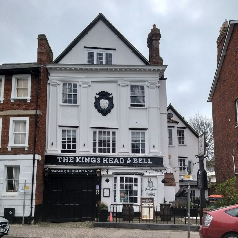
The Kings Head & Bell, the oldest pub in the oldest town.
There has been an inn on this site since before 1554 making it one of the oldest, if not the oldest pub in Abingdon.
Abingdon is the longest continually inhabited town in the country. . . . — — Map (db m216274) HM
Oxford Preservation Trust
Archaeology,
the Castle Ditch
and its skeletons
In 2003 excavations uncovered the Castle Ditch
part of the defences of the Norman Castle.
64 human skeletons were found buried here,
many dating from the late . . . — — Map (db m124273) HM
Near this place the Baptists of Oxford worshipped from 1661 to 1715 in the house of Richard Tidmarsh (minister 1661 – 1691). Baptisms took place in the stream below. The meeting-house was destroyed by rioters in 1715.
Erected by members . . . — — Map (db m124319) HM
Near to this Spot
Stood the King’s Houses
Later Known as
Beaumont Palace
King Richard I
Was Born Here in 1157
And King John in 1167 — — Map (db m124426) HM
Christ Church
Oxford’s Unique Foundation of College and Cathedral
The collegiate University of Oxford contains within it almost 40 independent educational institutions, or colleges. Christ Church is the largest. It is also, uniquely, the . . . — — Map (db m124409) HM
Christ Church & Its Meadow
Christ Church, on your right, was founded in 1525 by Cardinal Wolsey and is one of the University's best known colleges. Its chapel is the city's cathedral and contains the shrine of Oxford's patron saint, St Frideswide. . . . — — Map (db m130820) HM
Cornmarket & Market St
Cornmarket is a busy modern shopping street that has been a main road since Saxon times. It was formerly known as Northgate Street after the gate in the city wall which stood beside the Saxon tower of St Michael's Church . . . — — Map (db m130817) HM
This Street
Known Till 1300 As
Great Jewry Contained
Many Houses of the Jews
Including the Synagogue
Which Lay to the North
Of Tom Tower
1931 — — Map (db m124415) HM
Hythe Bridge Street
Hythe Bridge Street dates back to at least 1233 when it provided access across the Castle Mill Stream, a branch of the river Thames, to two of Oxford's great abbeys. Sadly, there are now only a few traces of Osney Abbey (founded . . . — — Map (db m130816) HM
New Road was new in 1770, built by a turnpike trust as a western exit from the city centre. It sliced through the former Oxford Castle bailey (the open space within the castle walls), providing an ideal site for what became the city's principal . . . — — Map (db m124318) HM
Oxford Preservation Trust
Old
County Hall
(1841)
This castellated building housed two courts, one civil, one criminal. Today, the building forms part of the Oxfordshire County Council offices in County Hall and one of the courts still . . . — — Map (db m124521) HM
Oxford Castle dates from 1071 and stamped the authority of England's new Norman rulers on the town. It changed the layout of this area but incorporated an earlier watch-tower (c.1020) which became the tower of St George's Church.
The castle . . . — — Map (db m124308) HM
( the marker is a series of medallians set into the stone pavement )
c.700 St Frideswide founds a Monastery by the River Thames
1009 The Saxon town is attacked by the Danes
1066 The Norman Conquest
1071 Robert D’Oilly . . . — — Map (db m122338) HM
To the Glory of God
And in Grateful Commemoration
of His Servants
Thomas Cranmer
Nicholas Ridley
Hugh Latimer
Prelates of the Church
of England
Who Near This Spot
Yielded Their Bodies
To Be Burned
Bearing Witness to the . . . — — Map (db m124255) HM
In Memory
of
Those Who
Fought and
Those Who
Fell
1914 - 1918
( inscribed on the steps )
For Those Who Fought 1914 - 1918 And Those Who Fell
and
1939 – 1945
And All Others Who Have Given Their Lives
In the . . . — — Map (db m124354) WM
Welcome to Oxfordshire County Council
The modern building in front of you is County Hall, headquarters of Oxfordshire County Council. It was opened by Her Majesty the Queen in 1976. The County Council is responsible for key public services in . . . — — Map (db m124271) HM
You are standing on Pacey's Bridge which crosses two branches of the Castle Mill Stream, itself a branch of the River Thames. The original bridge was constructed in 1770 when Park End Street and New Road were built as a turnpike road to provide a . . . — — Map (db m124320) HM
Oxford Preservation Trust
Prison
D Wing
(1790)
William Blackburn designed D Wing, the Debtors' Tower and C Wing. When the prison expanded St. George's Chapel was demolished, though the ancient Crypt
remains. Oxford Castle Unlocked . . . — — Map (db m124277) HM
Oxford Preservation Trust
Prison
Debtors’ Tower
(1790)
This Tower was built to imprison debtors who owed money. A rare triangular stone staircase leads to four floors divided into cells, some with fireplaces. Prisoners remained in prison . . . — — Map (db m124276) HM
Radcliffe Square, the historic heart of Oxford University has been called the finest square in Europe (Pevsner). It was created by the university authorities in the 1730s by demolishing the medieval houses to make a 'university forum'. It is . . . — — Map (db m124256) HM
The Reredos is
Dedicated to God
With Praise and
Thanksgiving
In Memory of All
S. Aldgate’s Men Who
Gave Their Lives in
The Great War 1914-19
Robert Allsworth · Harold Bricknell · Charles H. Bull · Sidney F. Bull · Fred Butler . . . — — Map (db m124412) WM
The tree-lined avenue of St Giles' is named after the Norman St Giles’ Church in front of you. The area lies outside the original city wall and development began in the 12th century as Oxford's population grew. Some early properties were farms but . . . — — Map (db m124254) HM
The Crown Inn was already nearly three centuries old when it acquired its name in 1625. The Crown was one of the first coaching houses in Oxford, which was a great coaching centre until the coming of the railway in 1835. The present building is . . . — — Map (db m124355) HM
The building in front of you is the University Church of St Mary the Virgin. This was the hub of the University of Oxford from the end of the 12th century when organised teaching first began. Most of the church dates from the 15th century but the . . . — — Map (db m124257) HM
Oxford's curved High Street was praised by the architectural historian Nikolaus Pevsner as ‘one of the world's great streets' with its glorious mix of college buildings and medieval to 18th century houses. The building opposite you is an addition . . . — — Map (db m124258) HM
The Motte and Bailey
Oxford Castle was built in 1071 by Robert d'Oilly who had accompanied William the Conqueror from Normandy to England in 1066. The Castie was surrounded by a moat from which material came to form both a high Mound or Motte and . . . — — Map (db m124274) HM
Oxford Preservation Trust
The Perimeter
Wall at Oxford Prison
(1790)
The wall is built close to a stream using large stones with a rubble inner core and smaller loose stones above, and later, razor wire. All this made escape underneath or . . . — — Map (db m124275) HM
The Plain & Magdalen Bridge
You are standing at the edge of The Plain, the eastern approach to the city centre. On the traffic island is the Victoria Fountain, built in 1899 where the toll-house once stood. Behind you is the 18th-century . . . — — Map (db m131298) HM
This Stone Was Laid
on
The Sixth Day of July 1895
Being the Wedding Day of HRH The Duke of York
And HSH Prince Victoria Mary of Teck
by
Thomas Lucas Esquire Mayor
Thomas M. Taphouse Esquire Sheriff
John Paprell & Son Builders . . . — — Map (db m124416) HM
This Monument was Erected by the Officers Non Commissioned Officers and Men of the Second Battalion Oxfordshire Light Infantry in Memory of Their Comrades Who Died Between the 15th of August 1897 and the 4th of November 1898
Killed by . . . — — Map (db m124270) WM
Oxford Preservation Trust
Vaulted
Well Chamber
(13th century)
The Chamber houses a 54 feet deep brick-faced well which drops to the water level below the Mound. This provided a supply of fresh water to the occupants of the Tower which once . . . — — Map (db m124520) HM
Victoria
Fountain
Inaugurated By
HRH Princess Louise
May 25 1899
Restored 2009
by Oxford City Council and
Oxford Preservation Trust
Supported by
East Area Parliament, Magdalen College and
CPRE Oxfordshire Buildings Preservation . . . — — Map (db m124522) HM
William
Wilkinson
1819 – 1901
Architect of the Randolph Hotel
and designer of North Oxford
Victorian suburb
lived and practised here
1860 - 1886 — — Map (db m124424) HM
There were three sieges of Oxford in the English Civil War. The city was the centre of Royalist resistance to the Parlimentarian assault on government. The first siege engagement was in May 1644 but King Charles escaped. In May 1645 a second siege . . . — — Map (db m233484) HM
Water power from the Thames
Although the Romans introduced watermills to Britain they mainly relied on slave labour to grind grain by hand. As a result mills did not become numerous until
Saxon times. By the time of Domesday there were more-than . . . — — Map (db m124419) HM
1871-1956
Awarded the Victoria Cross for valour while serving as a Corporal in the Royal Engineers
Born here and spent his youth in Thame — — Map (db m233326) HM
All Hallows Church
This yard is all that is left of All Hallows Church. It stood close to the castle walls and the priests were provided by the College of Saint Nicholas, which was sited nearby. The college was closed at the end of Henry . . . — — Map (db m231216) HM
In Medieval times this street continued right across the open space in front of you. Archaeologists have discovered the remains of timber houses dating back to the 11th and 12th Century.
This part of Wallingford has been called 'Cane-croft and . . . — — Map (db m231275) HM
A story of survival
A church has stood on this site, at the centre of Wallingford, since Norman times.
It was the only church to escape serious damage in the Civil War but it didn't remain unscathed for long. In 1653, during a turbulent . . . — — Map (db m231158) HM
For the more enduring memory of
Thomas Bennett, Esquire of Clapcote
whose son, Sir Thomas Bennett, Knight
in the year 1616,
provided out of his estate £20* yearly
for 15 poor and aged folk
of Wallingford
This monument
is, in . . . — — Map (db m231160) HM