Near Point Prim Road (Prince Edward Island Route 209) 11 kilometers west of Trans-Canada Highway (National Route 1).
English:
Despite its initial success, the Prince Edward Island Steam Navigation Company and its vessel, the St. George, ran into difficulties. Even with investments from New Brunswick and Nova Scotia, steamboats were . . . — — Map (db m140249) HM
Near Point Prim Road (Prince Edward Island Route 209) 11 kilometers west of Trans-Canada Highway (National Route 1).
English:
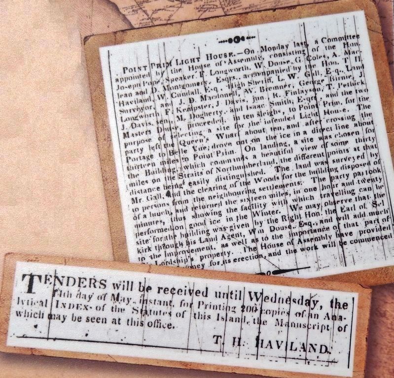
Prince Edward Island's contribution to Nova Scotia's lighthouses inspired the question: What about building a lighthouse here?
Petitions for lighthouses began to appear before government by the late 1830s. Concerned . . . — — Map (db m140246) HM
Near Point Prim Road (Prince Edward Island Route 209) 11 kilometers west of Trans-Canada Highway (National Route 1).
English:
At the same time that the Island was grappling with the issue of lighthouses, it found itself dealing with an issue of a different sort: Mail delivery.
Mail delivery was very important, representing the Island's . . . — — Map (db m140247) HM
Near Point Prim Road (Prince Edward Island Route 209) 11 kilometers west of Trans-Canada Highway (National Route 1).
English:
Late in the summer of 1864, two events descended upon the city of Charlottetown. One was a circus; the other, a political conference. Of the two, it was the circus that captured the attention of Islanders. But it was the . . . — — Map (db m140250) HM
Near Point Prim Road (Prince Edward Island Route 209) 11 kilometers west of Trans-Canada Highway (National Route 1).
English:
Imagine being aboard a ship on a dark, stormy night. The wind is howling fiercely, pushing large waves over the sides of your vessel. You are at the mercy of the elements. Picture a lack of navigational aids, creating a . . . — — Map (db m140245) HM
On Canoe Cove Road (Prince Edward Island Route 19A) just north of Prince Edward Island Route 19, on the left when traveling north.
The School For more than a century the Canoe Cove School provided state-of-the-art education to students grades one through ten. This sturdy heritage building launched the successful careers of doctors, lawyers, nurses, teachers, . . . — — Map (db m139457) HM
History of the Cavendish Area.
There is archaeological evidence that ancestors of the present-day Mi’kmaq lived on the shores of nearby New London Bay. It is very likely these early Islanders would have travelled here to hunt, . . . — — Map (db m139369) HM
25 July, 1883. Thanks to a weekend of violent storms there is a heavy sea running. A few farmers watch with astonishment as a magnificent sailing vessel, driven by a mountain of canvas, slams onto the Cavendish sandbars. The air iš alive . . . — — Map (db m139391) HM
Sea Stories From the first peoples through modern times, the fishery has been vital
to the people living along this shore. As Lucy Maud Montgomery
remembered: Many of the farmers had a fishing house on the shore field
of their . . . — — Map (db m139429) HM
Toward the end of the 1800s, Prince Edward Island became known as an excellent vacation spot. Its clean air, rural landscapes and beautiful beaches were offered to travellers made weary by the stress of urban
life. By the 1920s, thanks . . . — — Map (db m139431) HM
Near Cavendish Road (Prince Edward Island Route 6) close to Prince Edward Island Route 13, on the right when traveling east.
English:
Internationally renowned author, Lucy Maud Montgomery was born in New London, Prince Edward Island. After her mother's death in 1876, she lived with her maternal grandparents in Cavendish until 1911, when she married and moved to . . . — — Map (db m80283) HM
Near Grafton Street at Great George Street, on the right when traveling north.
English:
1864 was an important year in Charlottetown. The Charlottetown Conference, held in September, gave delegates from Nova Scotia, New Brunswick, Prince Edward Island and the colony of Canada one week to meet, share ideas, . . . — — Map (db m141114) HM
On Water Street (Prince Edward Island Route 1) at Grafton Street, on the left when traveling north on Water Street.
English: The Confederation Centre of the Arts was officially opened by Queen Elizabeth II on October 6, 1964 as a living memorial to the Fathers of Confederation. Located beside Province House in Queen Square, it was designed by the . . . — — Map (db m149912) HM
On Queen Street at Grafton Street, on the left when traveling south on Queen Street.
English: This cannon fell off a cliff near Fort Amherst and landed in Charlottetown Harbour. Pulled from the water by Theophilus DesBrisay, it was brought into town and placed in the ground outside his family's drug store, . . . — — Map (db m149597) HM
On Grafton Street at Great George Street, on the right when traveling east on Grafton Street.
English: A Neoclassical Design
Have you ever noticed that the building's design, including features such as columns and windows, is pleasingly symmetrical? This is one of the features that make Province House a fine example of . . . — — Map (db m137659) HM
On Grafton Street at Water Street (Prince Edward Island Route 1), on the right when traveling east on Grafton Street.
English: "From the beginning, the river drew people to settle its banks and use its waters to reach the settlements..." The Hillsborough River, Elsitkuk as the Mi'kmaq would say, is the Island's largest river. It runs east . . . — — Map (db m149601) HM
On Water Street east of Queen Street, on the right when traveling east.
English: The Bonded Warehouse across the street was often at the centre of one of Charlottetown's most controversial issues: prohibition. In 1901 Prince Edward Island was the first Canadian province to make it illegal to possess, . . . — — Map (db m149598) HM
On Rochford Street close to All Souls' Lane, on the right when traveling north.
English:
This 1888 chapel, designed by William Critchlow Harris, Jr., is a masterful example of High Victorian Gothic Revival architecture in Canada. Its robust design is distinguished by rough textures in rust-red Prince Edward Island . . . — — Map (db m80226) HM
English:
Born at Three Rivers, Brudenell Point, Macdonald, a merchant and shipbuilder, served as a member of the Legislative Assembly (1853-58) and of the Legislative Council (1867-72). He attended the Charlottetown and Quebec Conferences . . . — — Map (db m80271) HM
On Veterans Memorial Highway (St. Peters Road) (Prince Edward Island Route 2) just south of Oakland Drive, on the left when traveling south.
In 1786 John Cambridge purchased approximately 300 acres along Wright's Creek, which was then called Bird Island Creek. Around 1800 he built a 22 foot-high mill dam at the head of tide on the creek, and went on to build a saw mill, grist mill and . . . — — Map (db m140303) HM
On Great George Street at Dorchester Street, on the right when traveling south on Great George Street.
Angus Bernard MacEachern (1759-1835), first Bishop of the
Diocese of Charlottetown, founded St. Andrew's College,
the first post-secondary institution in the colony, on 30
November 1831. In January 1855, the college was re-located
and . . . — — Map (db m201602) HM
On Queen Street at Grafton Street, on the right when traveling south on Queen Street.
English:
On December 24, 1810, Thomas Desbrisay Jr. opened an apothecary shop on this site to supply drugs and medicine to the people of Prince Edward Island. Until then, many Islanders relied more on home remedies or obtained medicines . . . — — Map (db m80262) HM
On Kent Street south of West Street, on the left when traveling south.
English: Built in 1877 for James and Edith Peake, Beaconsfield was one of Prince Edward Island's most elegant homes. Featuring the finest in materials and craftsmanship, it was also equipped with all the latest conveniences of the . . . — — Map (db m149595) HM
On Grafton Street at Water Street (Prince Edward Island Route 1), on the right when traveling east on Grafton Street.
English: Across Charlottetown Harbour on the west side was the home base for the Acadians in the early years of the 1700's. It was called Port-la-Joye and Fort Amherst by the English. The Mi'kmaq called it Skma qan which . . . — — Map (db m149600) HM
On Kent Street just south of Queen Street, on the left when traveling north.
This bell was affectionately known as “Big Donald” honouring Fire Chief Donald MacKinnon 1875-1879. Cast in 1875 by William Blake & Co., formerly H.W. Hooper & Co., Boston, Mass. Cracked and recast in 1877 Cracked and recast in 1884 . . . — — Map (db m149596) HM
On Water Street (Prince Edward Island Route 1) at Grafton Street, on the left when traveling north on Water Street.
English: Even though it was the capital of Canada's smallest province, it took almost 100 years before Charlottetown became of strong historical importance. On August 31, 1864 the delegates began arriving for what is now referred to . . . — — Map (db m149905) HM
On Kent Street close to Pownal Street, on the left when traveling east.
This marker is composed of two plaques on either side of the entrance.
In 1930, the Canadian National Railway (CNR) decided to build a hotel in Charlottetown, Railway hotels were the standard of comfort and service, but the new Canadian . . . — — Map (db m80227) HM
On Kent Street near Queen Street, on the left when traveling east.
Samuel Holland Report Sept 14, 1767
The Capital to be called Charlotte Town is proposed to be built on a point of the harbor of Port Joy, betwixt York and Hillsborough Rivers, as being one of the best, and nearly central Parts of the . . . — — Map (db m207811) HM
On Richmond Street at Great George Street, on the right when traveling west on Richmond Street.
These pivotal meetings laid the groundwork for Canadian Confederation. Here in September 1864, the Charlottetown Conference brought together leaders from the colonies of Prince Edward Island, Nova Scotia, New Brunswick, and the Province of Canada . . . — — Map (db m200977) HM
On Queen Street near Kent Street, on the right when traveling south.
English:
Built in 1888, the Charlottetown City Hall is the oldest municipal hall in Prince Edward Island. Designed by Phillips and Chappell in the Romanesque Revival style often favoured for 19th-century civic buildings, it originally . . . — — Map (db m80230) HM
On Weymouth Street at Water St, on the right when traveling north on Weymouth Street.
Built of Island and Wallace Sandstone, the Charlottetown railway station opened July 8, 1907. At a time when both people and goods travelled extensively by train, the station was a busy place indeed. Housing public facilities and administrative . . . — — Map (db m201323) HM
On Grafton Street at Water Street (Prince Edward Island Route 1), on the right when traveling east on Grafton Street.
English: Charlottetown is the home of two important educational institutions. The University of Prince Edward Island was established in April 1969. It resulted from a merger of two institutions: Prince of Wales College that began as . . . — — Map (db m149899) HM
English:
Born in Charlottetown, a Father of Confederation, Gray served in the Imperial cavalry (1831-52) before entering politics. Elected in 1858 to represent Queen's County, he served as Premier of the province (1863-65) and played a . . . — — Map (db m80269) HM
On Grafton Street at Queen Street, on the right when traveling east on Grafton Street.
English:
Opened by Her Majesty the Queen in 1964 as Canada's National Memorial to the Fathers of Confederation, the Centre is an outstanding example of an institution dedicated to the arts. The extensive cultural complex includes a . . . — — Map (db m80264) HM
On Water Street at Haviland Street on Water Street.
English:
This apartment building, completed in 1890, is a handsome example of the Queen Anne Revival in Canada. Admired for its picturesque qualities, this style was popular in Canadian domestic architecture from the 1880s to the 1910s. As . . . — — Map (db m80207) HM
Near Richmond Street close to Great George Street.
English:
Born in Charlottetown and called to the bar in 1831, Palmer was a member of the legislature (1835-60), and of the Legislative Council (1860-73). Between 1848 and 1873 he held several cabinet posts, including that of President of . . . — — Map (db m80270) HM
Near Richmond Street close to Great George Street.
English:
Born in Ireland, Whelan immigrated to Halifax c. 1836 and became a protégé of Joseph Howe. As a journalist in Charlottetown be published the short- lived Palladium in 1845, became editor of the Morning News in 1846, . . . — — Map (db m80266) HM
English:
A native Prince Edward Islander, Coles, first elected in 1842, represented the constituency of Queen's in the House of Assembly of the Island until his retirement because of ill health in 1868. Co-founder, with Edward Whelan, of . . . — — Map (db m80273) HM
English:
Great George Street is richly evocative of both its 18th-century origins and its subsequent development as one of Charlottetown's principal streets. Clearly focused to Province House, the seat of Island government and the . . . — — Map (db m80200) HM
On Great George Street close to Water Street, on the left when traveling south.
English:
When a large steamer anchored in Charlottetown Harbour in 1864, few took notice of it or the politicians aboard. Charlottetown was preoccupied with another visitor to its little town: the circus. Drawing huge crowds and filling . . . — — Map (db m80199) HM
The first Hillsborough Bridge was constructed as a railway link to the southeastern part of the Island, although it was also a carriage bridge, too. The steel structure consisted of 12 spans. To facilitate river traffic it had a swing span over the . . . — — Map (db m80184) HM
On Water Street just east of Queen Street, on the left when traveling east.
English: In 1775, privateers from the American Colonies launched their first attack on foreign soil. Disobeying the orders of General George Washington, these respected Captains descended on an unsuspecting, unarmed Charlotte Town. . . . — — Map (db m149599) HM
On Grafton Street at Water Street (Prince Edward Island Route 1), on the right when traveling east on Grafton Street.
English: Charlottetown has been working on its beautification for well over 150 years. On Arbor Day May 24, 1884 more than 300 trees were planted in the squares and along the streets. The tradition continues. Our trees are . . . — — Map (db m149902) HM
On Water Street (Prince Edward Island Route 1) at Grafton Street, on the left when traveling north on Water Street.
English: The Colonial Building, now known as Province House, is in the middle of Queen Square. It was the prime location for the meetings of the Fathers of Confederation in 1864. The building was officially opened on January 26, . . . — — Map (db m149910) HM
On Grafton Street at Water Street (Prince Edward Island Route 1), on the right when traveling east on Grafton Street.
English: Victoria Park, at the west end of the city, was vested by the Crown to the City of Charlottetown in 1873. The 40 acres of land presents a gentle place protected by a special Act that declares the park "for the sole purpose . . . — — Map (db m149901) HM
On Richmond Street close to Great George Street, on the left when traveling east.
Roland Taylor • Alfred Riggs
Feb. 18th • Feb. 27th
1900
To the men of the
Royal Canadian Regiment
who by their valour and efficiency
have made manifest to the world
Canada’s ability and willingness to share . . . — — Map (db m80281) WM
On Water Street (Prince Edward Island Route 1) at Grafton Street, on the left when traveling north on Water Street.
English: Architecturally speaking, Charlottetown is predominately a wooden town with buildings dating back to the early 1800's. When you see a brick building you can be pretty sure it was built after the Great Fire of 1866 that . . . — — Map (db m149909) HM
On Grafton Street at Water Street (Prince Edward Island Route 1), on the right when traveling east on Grafton Street.
English: In 2015, the celebration marking, Charlottetown's 250 years on its chosen site provides an excellent opportunity for Charlottetown to ponder its past and its future. As a home to many new Canadians, the responsibility to . . . — — Map (db m149903) HM
On Grafton Street close to University Avenue, on the right when traveling east.
Side A
Erected by the Citizens of Charlottetown in memory of those
from Prince Edward Island who gloriously laid down their
lives in the Great War in honour forevermore
of all who served therein
1914 - 1918
1939 - 1945 . . . — — Map (db m80280) WM
Near Richmond Street close to Great George Street, on the right.
English
Completed in 1847, this neo-classical building was designed and built by local architect Isaac Smith to accommodate the provincial legislature and administrative offices. It also housed the Island's Supreme Court until 1872. . . . — — Map (db m80282) HM
On Water Street (Prince Edward Island Route 1) at Grafton Street, on the left when traveling north on Water Street.
English: The Provincial Government has its administrative headquarters in the west end of the city, their Court House on the waterfront and the offices for official political parties are housed in the Coles Building on Queen Square. . . . — — Map (db m149911) HM
On Great George Street at Sydney Street, on the right when traveling south on Great George Street.
On this site stood
Queen Square School For Boys
operated as a public school
1878 to 1962
This memorial is erected to honor all students
and its teachers who were part of this school and
its traditions through these years — — Map (db m201597) HM
Near Water Street close to Hillsborough Street, on the left when traveling east.
English:
Built in 1876, this Island sandstone building was originally the office of the mechanical branch of the Prince Edward Island Railway. Later, it became the brass shop where brass parts required by the railway were fabricated. The . . . — — Map (db m80182) HM
On Prince Street close to Water Street, on the right when traveling south.
English:
On November 30, 1905 fire destroyed several of the wooden manufacturing shops at the Charlottetown rail yard. To reduce the risk of future fires, it was decided to rebuild the shops in brick. E.A. Wallberg of Montreal was the . . . — — Map (db m80181) HM
On Queen Street, on the right when traveling south.
Samuel Holland was appointed Surveyor General for the eastern seaboard of North America by the Board of Trade and Plantations in London England. In 1764, he began his survey and his plan outlined 67 lots, 3 counties and 14 parishes. He also . . . — — Map (db m202745) HM
On Haviland Street close to Water Street, on the left when traveling south.
294 Sherman tanks were purchased by Canada after World War II and used by the Canadian Army (both Regular and Reserve) from 1946-1972.
This is a late production model of the orignal Sherman tank introduced in 1943 that incorporated many . . . — — Map (db m80224) HM WM
On Water Street close to Pownal Street, on the left when traveling west.
Born in Charlottetown, Davies studied law at the Inner Temple and was admitted to the bar in 1867. A member of the Legislative Assembly (1872-9) and Premier for the last three years of that period, he defended the rights of tenant farmers while . . . — — Map (db m80206) HM
On Water Street (Prince Edward Island Route 1) at Grafton Street, on the left when traveling north on Water Street.
English: Government House, at the west end of the city was built in 1834. It is a gracious house and still serves as the official residence of the Island's Lieutenant Governor. Their Honours host many events to which the public is . . . — — Map (db m149913) HM
On Great George Street at Dorchester Street, on the right when traveling south on Great George Street.
With its souring spires, picturesque pinnacles and intricate tracery, St. Dustan”s Basilica is an excellent example of the High Victorian Style in Canadian architecture. Erected between 1897 and 1907, it was severely damaged by fire in . . . — — Map (db m201601) HM
Near Great George Street close to Water Street, on the left when traveling south.
English:
Between 1827 and 1856 the first complete hydrographic survey of the Gulf and River St. Lawrence was carried out by Captain Henry W. Bayfield and his assistants. From the time of Cartier, French and British navigators ad surveyed . . . — — Map (db m80198) HM
On Haviland Street at Sydney Street, on the left when traveling north on Haviland Street.
This memorial marks the location of The Charlottetown Hospital (1879-1982) The Charlottetown Hospital School of Nursing (1920-1971) and The School of X-ray Technology (1953-1971) The hospital, founded by Bishop Peter McIntyre and The Sisters of . . . — — Map (db m149594) HM
On Water Street (Prince Edward Island Route 1) at Grafton Street, on the left when traveling north on Water Street.
English: The City of Charlottetown was incorporated in April 1855. The present boundaries of the city are a result of an amalgamation of six surrounding communities in 1995. The City is governed by a mayor and 10 councilors. Its . . . — — Map (db m149908) HM
This double tenement, built by John and Elizabeth Gainsford, became a landmark in a city largely built of wood. It is Charlottetown’s oldest surviving brick building. For many years the east side was the home of John Iags, editor of “The . . . — — Map (db m104833) HM
On Prince Street close to Water Street, on the left when traveling south.
English:
The Hillsborough River watershed, totaling over 350 square kilometres, is the largest river system in Prince Edward Island. As a river highway, it provides a direct link to our rich human heritage, from the Mi’Kmaq who depended on . . . — — Map (db m80187) HM
On Water Street (Prince Edward Island Route 1) at Grafton Street, on the left when traveling north on Water Street.
English: The Port of Charlottetown has a history of wooden shipbuilding, local ferry wharves and shipping connections with the world. Family connections with the Westcountry of England made it a prime destination. Shipbuilders, . . . — — Map (db m149906) HM
On Water Street (Prince Edward Island Route 1) at Grafton Street, on the left when traveling north on Water Street.
English: In 1768 Charles Morris, a Halifax Surveyor, was directed to lay out the town under the directions of the Board of Trade and Plantations in London. Later the Island's first British Governor, Walter Patterson, through his . . . — — Map (db m149900) HM
On Grafton Street at Water Street (Prince Edward Island Route 1), on the right when traveling east on Grafton Street.
English: The railway played a major role in shaping Canada and it played an important role in the development of Prince Edward Island. The sod was turned for the PEI Railway on October 5, 1871 just north east of where you are . . . — — Map (db m149897) HM
On Water Street (Prince Edward Island Route 1) at Grafton Street, on the left when traveling north on Water Street.
English: The site of Charlottetown was chosen by Surveyor General Samuel Holland on his survey of St. John's Island. Now called Prince Edward Island, it was once called Epekwitk, which means "lying on the water", by the . . . — — Map (db m149904) HM
Near Richmond Street close to Great George Street.
English:
Born in Charlottetown, Haviland was called to the Prince Edward Island bar in 1846. He represented Georgetown in the legislature (1847-70), serving successively as Colonial Secretary, as Speaker, and as Solicitor-Genera1. As a . . . — — Map (db m80268) HM
On Prince Street near Water Street, on the left when traveling south.
English:
The Prince Edward Island Railway brought Islanders together, put them to work, and even made them Canadians.
Before the Railway was built on Prince Edward Island you could live within ten miles of another village and hardly . . . — — Map (db m80185) HM
On Grafton Street at Water Street (Prince Edward Island Route 1), on the right when traveling east on Grafton Street.
English: The Railway Station stands not far from where you now stand. The air was once full of steam, the sound of train whistles and shunting rail cars. It was a busy place with the Western train, the Eastern train and the Murray . . . — — Map (db m149898) HM
On Prince Street at Prince St, on the right when traveling north on Prince Street.
Trinity Church
was founded in 1778 by
Benjamin Chappell,
friend of John Wesley.
The congregation continued in
the Wesleyan Methodist
tradition until 1925 when,
choosing the name Trinity,
it became a founding
congregation of the
United . . . — — Map (db m201326) HM
Near Richmond Street close to Great George Street.
English:
Born at Bedeque, Prince Edward Island, Pope was admitted to the bar in 1847, became Colonial Secretary in 1859, was elected to the Legislative Assembly representing Queen's County in 1863 and continued to serve in the Assembly . . . — — Map (db m80272) HM
On Great George Street at Lower Water Street, in the median on Great George Street.
Work of art by Jules LeSalle
In recognition of the 150th anniversary of the 1864 Charlottetown and Québec conference, which led to the creation of Canada, bronze statue of two Fathers of Confederation were commissioned, one for . . . — — Map (db m202748) HM
On Grahams Road (Prince Edward Island Route 20) at Prince Edward Island Route 6, on the right when traveling north on Grahams Road.
Lucy Maud Montgomery, daughter of
Hugh John Montgomery and Clara
Woolner MacNeill, was born in this
house on November 30, 1874. — — Map (db m138186) HM
On Cavendish Road (Prince Edward Island Route 6) at Church Hill Road, on the left when traveling east on Cavendish Road.
Dedicated to the men
and women of this
community who
served their country
in World War 1, World
War II, and the Korean
War and in grateful
tribute to those
who made the
supreme sacrifice.
W.W. II
W.O. II Fredrick L. Bulman
Pte. . . . — — Map (db m139243) WM
Near Hache Gallant Drive, 1.2 kilometers east of Prince Edward Island Route 19, on the left when traveling east.
English: Working out of Fort Amherst between 1764 and 1765, Captain Samuel Holland, an engineer, directed a small team to produce an accurate survey of every inch of St. John's Island. It was the first phase of a major survey of . . . — — Map (db m151802) HM
Near Hache Gallant Drive, 1.2 kilometers east of Prince Edward Island Route 19, on the left when traveling east.
English: ”It is three years since the last refugee arrived on the island. They had to endure heavy losses and great hardship in getting here, and on arrival, they found themselves so to speak destitute… My Lord, unless you . . . — — Map (db m151801) HM
Near Hache Gallant Drive, 1.5 kilometers east of Prince Edward Island Route 19.
English: With Island history as your backdrop, you're looking out at Charlottetown Harbour, the Hillsborough River, Governors Island, and the bluffs of Keppoch. In the summertime, this waterway hosts an abundance of . . . — — Map (db m151792) HM
Near Hache Gallant Drive, 1.2 kilometers east of Prince Edward Island Route 19, on the left when traveling east.
English: Michel Haché-Gallant and Anne Cormier were the first Acadians to join the French colonists at Port-la-Joye. They arrived in 1720 from Beaubassin with four of their children. By 1730, eight Gallant children owned properties . . . — — Map (db m151797) HM
Near Hache Gallant Drive, 1.2 kilometers east of Prince Edward Island Route 19, on the left when traveling east.
Français:Première famille acadienne établie en permanence à L’Île-du-Prince-Édouard Ancêtres des familles Gallant et Haché du Canada et des États-Unis arrivés à Port-La-Joye en 1720 Monument érigé en 1965 par leurs . . . — — Map (db m151800) HM
Near Hache Gallant Drive, 1.2 kilometers east of Prince Edward Island Route 19, on the left when traveling east.
English: This timeline presents events that helped shape the history of Port-la-Joye—Fort Amherst, Prince Edward Island and Canada. Port-la-Joye was an imperial outpost for France for 38 years. For another ten years, Fort . . . — — Map (db m151804) HM
Near Hache Gallant Drive, 1.2 kilometers east of Prince Edward Island Route 19, on the left when traveling east.
English:We are in Port la Joye, one of the most beautiful harbours that the eye can behold. —Louis Denys de la Ronde, November 6, 1721 In 1720, three hundred men, women and children were brought from France to . . . — — Map (db m151803) HM
Near Haché Gallant Drive, 1.2 kilometers east of Prince Edward Island Route 19, on the left when traveling east.
English:
From 1720 to 1768 this site was an important colonial base, first for France and later Great Britain. One of the first permanent French settlements on the island, Port-la-Joye served as the seat of colonial government for . . . — — Map (db m139447) HM
On Prince Edward Island Route 19 just south of Rogers Passage Lane, on the left when traveling south.
English:
In 1764 the British government decided to undertake a systematic survey of its North American territory, recently enlarged in the war with France. For this purpose Captain Samuel Holland was put in charge of the northern . . . — — Map (db m139436) HM
Near Hache Gallant Drive, 1.2 kilometers east of Prince Edward Island Route 19, on the left when traveling east.
English: Lieutenant-Colonel Andrew Rollo arrived with a force of five hundred soldiers and took possession of Port-la-Joye on behalf of the British on August 17, 1758. The French governor at Louisbourg had given up both Île . . . — — Map (db m151799) HM
Near Haché Gallant Drive, 1.2 kilometers east of Prince Edward Island Route 19, on the left when traveling east.
English:
Undertaken here in 1758, this expulsion was one of the largest and the deadliest of the Acadian deportations that took place between 1755 and 1762. As part of a strategy to dismantle the French colony of Île Saint-Jean . . . — — Map (db m139446) HM
Near Hache Gallant Drive close to Blockhouse Road, on the left when traveling east.
English:
The Grand Dérangement
L’Acadie, established by France in 1604, was a strategically located and highly coveted colony. In 1713, it was handed over to England and renamed Nova Scotia. The foundation of Halifax, in 1749, . . . — — Map (db m80437) HM
Near Hache Gallant Drive, 1.2 kilometers east of Prince Edward Island Route 19, on the left when traveling east.
English: There has been an aboriginal presence on the Island for at least ten thousand years. The Mi’kmaq became allies and important trading partners with the French in the 1600s and later sided with them in battles against the . . . — — Map (db m151798) HM
On Prince Edward Island Route 20, 0.5 kilometers south of Prince Edward Island Route 234, on the left when traveling north.
Minister of Cavendish and
New London Churches 1838 - 1845.
First missionary sent out
to any foreign field by the
Presbyterian Church in Canada — — Map (db m140157) HM
On Prince Edward Island Route 20, 0.5 kilometers south of Prince Edward Island Route 234, on the left when traveling north.
Built of a people’s love to the memory of our glorious dead
Pte Archibald Campbell,
6th Can. M. Rifles.
Apr. 12, 1898-June 2 1916
Killed in action in France
Gr. Arthur P. Johnstone,
2nd Can. Siege Batty.
June 10, . . . — — Map (db m140108) WM
On Prince Edward Island Route 20, 0.5 kilometers south of Prince Edward Island Route 234, on the left when traveling north.
Dedicated To The Memory Of Our Youth
Who Served In World War II
Sgt. Elmer S. Macleod
1915 - 1944
Killed In Italy
W.O.2 Allison F.W. Macleod
1920 – 1943
Missing In Malta
Pte. W. Wallace Bernard
1904 -1945
Died . . . — — Map (db m140158) WM
The three buildings on this site represent a "family” and all were once navigational aids. The lighthouse beacon is still maintained by the Canadian Coast Guard as part of the marine communication system used by ship traffic in the . . . — — Map (db m138223) HM