3 entries match your criteria.
Related Historical Markers
By James Thomson
Nansemond County / Norfolk County Marker
SHOWN IN SOURCE-SPECIFIED ORDER
| |
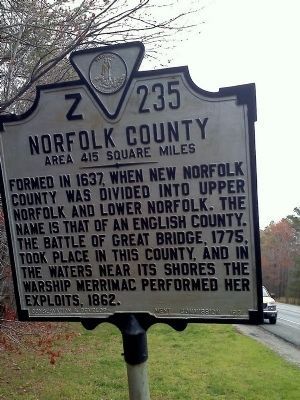
Nansemond County. Area 423 Square Miles. Formed in 1637 from New Norfolk County, it was first called Upper Norfolk County, but in 1642 it was named Nansemond for an Indian tribe. Dismal Swamp is partly in this county. . . . — — Map (db m118820) HM |
| | In this vicinity, in 1775, was the southern end of a causeway, with bridges, by which the swamp and stream were crossed. Here William Woodford's Virginia riflemen defended the passage. When Lord Dunmore's British regulars attempted to cross the . . . — — Map (db m29926) HM |
| |
(side 1)
This monument honors
Patriots who assembled
at this site in the Cause of
American Freedom in 1775
American Patriots
at the Battle
Second Virginia Regiment
Commanded by
Colonel William Woodford,
of . . . — — Map (db m211239) HM |
Apr. 25, 2024