Battle for Lexington
Ingersoll's Last Stand
ó Forrest's First West Tennessee Raid ó
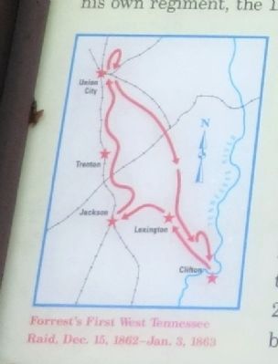
Gen. Nathan Bedford Forrest led his cavalry brigade on a raid through West Tennessee, Dec. 15, 1862-Jan 3, 1863, destroying railroads and severing Gen. Ulysses S. Grantís supply line between Columbus, Kentucky, and Vicksburg, Mississippi. Forrest crossed the Tennessee River at Clifton, defeated Union Col. Robert G. Ingersollís cavalry at Lexington, captured Trenton and Union City, and ranged briefly into Kentucky. He raided back through Tennessee, evaded defeat at Parkerís Cross Roads, and crossed the river again at Clifton. Grant changed his supply base to Memphis.
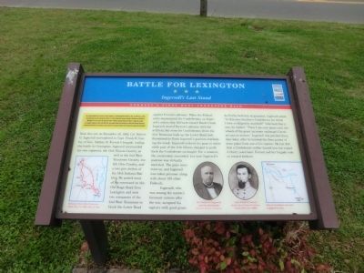
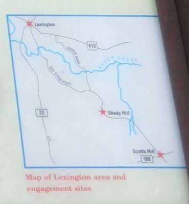
Near this site on December 18, 1862, Col. Robert G. Ingersoll surrendered to Capt. Frank B. Gurley, of Gen. Nathan B. Forrestís brigade, ending the battle for Lexington. Ingersoll commanded his own regiment, the 11th Illinois Cavalry, as well as the 2nd West Tennessee Cavalry, the 5th Ohio Cavalry, and a two-gun section of the 14th Indiana Battery. He posted most of his command on the Old Stage Road from Lexington and sent two companies of the 2nd West Tennessee to block the Lower Road against Forrestís advance. When the Federal units encountered the Confederates, on Ingersollís orders they fell back toward Beech Creek. Ingersoll slowed Forrestís advance with his artillery, but soon the Confederates drove the 2nd Tennessee back up the Lower Road and threatened to
flank Ingersollís position overlooking the creek. Ingersoll ordered his guns to retire while part of the 11th Illinois charged to push back the Confederate onslaught. For a moment, the cavalrymen succeeded, but soon Ingersollís position was virtually encircled. The guns were overrun, and Ingersoll was taken prisoner along with about 150 other Federals.Ingersoll, who was among the nationís foremost orators after the war, accepted his capture with good grace. As Gurley held him at gunpoint, Ingersoll asked, “Is this your Southern Confederacy for which I have so diligently searched?” Informed that it was, he replied, “Then I am your guest until the wheels of the great (prisoner exchange) Cartel are put in motion.” Ingersoll was paroled three days later, after he learned the finer points of draw poker from one of his captors. He lost $50 that a Confederate soldier loaned him but repaid it thirty years later. Forrest and his brigade rode on toward Jackson.
(Inscriptions under the photos in the lower center)
Col. Robert G. Ingersoll, postwar photograph-Courtesy Library of Congress; Capt. Frank B. Gurley, from Life of General Nathan Bedford Forrest (1899)
Erected by Tennessee Civil War Trails.
Topics and series. This historical marker is listed in this topic list: War, US Civil
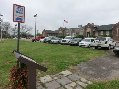
Location. 35° 38.814′ N, 88° 23.448′ W. Marker is in Lexington, Tennessee, in Henderson County. Marker is on South Main Street. The marker is located on the grounds of the Lexington Senior Citizens Center. Touch for map. Marker is at or near this postal address: 145 South Main Street, Lexington TN 38351, United States of America. Touch for directions.
Other nearby markers. At least 8 other markers are within walking distance of this marker. 31 Natchez Trace Drive (approx. 0.2 miles away); Hometown of Buddy Cannon (approx. 0.2 miles away); 58 South Main Street (approx. 0.2 miles away); 54 Main Street (approx. 0.2 miles away); 52 South Main (approx. 0.2 miles away); 50 South Main (approx. 0.2 miles away); 42 South Main Street (approx. 0.2 miles away); 40 South Main Street (approx. ľ mile away). Touch for a list and map of all markers in Lexington.
Credits. This page was last revised on June 16, 2016. It was originally submitted on June 30, 2014, by Don Morfe of Baltimore, Maryland. This page has been viewed 1,911 times since then and 30 times this year. Last updated on March 24, 2015, by J. Makali Bruton of Accra, Ghana. Photos: 1, 2, 3, 4. submitted on June 30, 2014, by Don Morfe of Baltimore, Maryland. • Bill Pfingsten was the editor who published this page.


