The Irish Brigade & the McNeill Rangers
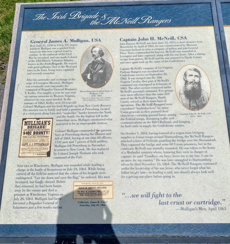
General James A. Mulligan, USA
Born June 25, 1830 in Utica, NY, James Adelbert Mulligan was a spirited Irish-American who wore a green scarf in combat. At the outbreak of the Civil War . . . — — Map (db m240181) HM
Exploring Fort Mulligan.
A trail system with interpretive exhibits describe the Fort’s construction, usage and strategic importance during the Civil War. Most of the site is wheelchair accessible, however several areas are inaccessible . . . — — Map (db m155441) HM
The strategic importance of Fort Mulligan becomes evident as you observe the surrounding terrain. Roads leading north to New Creek, west to Beverly, Buckhannon and Grafton, south
to Franklin and Staunton and east to Moorefield, Winchester
and . . . — — Map (db m14585) HM
In 1863, your view from here would have been of a barren, muddy landscape, with crude, smoking huts half buried in the hillsides. The area surrounding the Fort was most likely stripped of timber as the need for open fields of fire, fuel and . . . — — Map (db m155444) HM
You are now at the western end of Fort Mulligan. The acute angles at this end of the works were clearly designed to be occupied by several artillery pieces to fend off attacks from the Seneca Road and the ravine to the southwest.
Fort . . . — — Map (db m14536) HM
This is one of at least seven known gun positions at Fort Mulligan (note the depression in the angle), which would have dominated the crossroads at Petersburg and its ford on the South Branch of the Potomac River. Confederate General Early . . . — — Map (db m155443) HM
Clearly one of the Fort’s entrances, this “sally port” was probably
needed here to rush men and perhaps cannons out to defend
against an assault up the ravine behind you. This was the only
place a body of hostile infantry could . . . — — Map (db m14577) HM
As you stand here, near the middle of Fort Mulligan, its sheer size
becomes apparent. It is approximately 700 feet east to west and
400 feet north to south at its widest point. Surrounding you are
the Fort’s intricate inner works called . . . — — Map (db m14529) HM
In December of 1863, Colonel James Mulligan returned to
New Creek and Colonel Joseph Thoburn took command of the
1,785 Union soldiers at Petersburg. Confederate Major General
Fitzhugh Lee’s forces began to move on Petersburg on January 3rd, . . . — — Map (db m14519) HM