On North Valley Pike (U.S. 11) south of Martz Road.
Here, at Lacey’s Springs, Rosser’s Confederate cavalry attacked Custer's camp, December 20, 1864. Rosser and Custer (of Indian Fame) had been roommates at West Point. — — Map (db m649) HM
On Valley Pike (U.S. 11) north of Lacey Spring Road, on the left when traveling south.
Four miles west, Thomas Lincoln, father of the President, was born about 1778. He was taken to Kentucky by his father about 1781. Beside the road here was Lincoln Inn, long kept by a member of the family. — — Map (db m656) HM
On East Rockingham Street, 0.1 miles east of Stuart Avenue / East Side Highway (U.S. 340), on the right when traveling east.
Less than a month after his defeat at Kernstown, Gen. Thomas J. “Stonewall” Jackson retired to the Elk Run Valley to rest his troops and plan for the spring campaign. With his men camped all along Elk Run and into Swift Run Gap, Jackson . . . — — Map (db m2835) HM
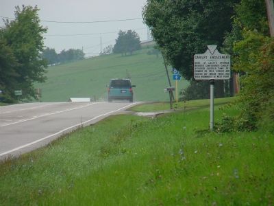
On South Main Street (U.S. 11) south of Monument Avenue, on the right when traveling south.
Here Stonewall Jackson, retreating up the Valley before the converging columns of Fremont and Shields, turned at bay, June 1862. A mile southeast Jackson’s cavalry commander, Ashby, was killed, June 6. At Cross Keys, six miles southeast, Ewell of . . . — — Map (db m239845) HM
On West Rockingham Street near West Spotswood Trail (Business U.S. 33), on the left when traveling west.
1862 & 1864 Valley Campaigns.
This eight-room brick dwelling was built in 1840 for Dr. Simeon B. Jennings, a former resident of Port Republic. At the time of the Civil War, it was one of only half a dozen houses located in the Conrad’s Store . . . — — Map (db m2916) HM
On Ore Bank Road (Virginia Route 708) near Mapleton Lane (County Route 967).
Port Republic Battlefield Civil War Site—Trail Stop 4.
Federal commander Tyler placed at least 3 artillery pieces on this high part of the “Coaling,” and lined 3 more guns down the slope to the road on your right. All morning fire from . . . — — Map (db m230191) HM
On Ore Bank Road (Virginia Route 708) at Mapleton Lane (County Route 967) on Ore Bank Road.
Port Republic Battlefield Civil War Site—Trail Stop 1
You are standing on the “Coaling.” By the Civil War this area was nearly devoid of trees, the timber having been used for the production of charcoal. This was the key Federal . . . — — Map (db m230192) HM
On South East Side Highway (U.S. 340) at Ore Bank Road / Lynnwood Road (Virginia Route 708), on the right when traveling east on South East Side Highway.
The cross road here roughgly divides the Confederate and Union lines in the battle of June 9, 1862. Jackson attacked Shields, coming southward to join Fremont, but was repulsed. Reinforced by Ewell, Jackson attacked again and drove Shields from the . . . — — Map (db m230190) HM
On Spotswood Trail (U.S. 33) west of Cross Keys Road (Virginia Route 276), on the right when traveling west. Reported missing.
Three miles south, on Mill Creek, Jackson’s rearguard, under Ewell, was attacked by Fremont, June 8, 1862. Trimble, of Ewell’s command, counterattacked, driving the Unionists back. Jackson, with the rest of his army, was near Port Republic awaiting . . . — — Map (db m230248) HM
On Port Republic Road (County Route 659) south of Cross Keys Road (Virginia Route 276), on the right when traveling south.
Here, June 8, 1862, Gen. J. C. Fremont—pursuing Gen. T. J. “Stonewall” Jackson—was checked by Gen. R. S. Ewell with part of Jackson’s army, which lay towards Port Republic. Federals engaged: 12,750, killed and wounded: 684. Confederates engaged: . . . — — Map (db m4056) HM
On Main Street (Business Virginia Route 42) at Mill Street, on the right when traveling south on Main Street.
In memory of Lt. Col. Thomas F. Wildes, 116th Ohio Regiment, who, when ordered by Gen. Sheridan to burn the town of Dayton, Va. in retaliation for the death of a Union officer, refused to obey that order, risking court-martial and disgrace. His . . . — — Map (db m88643) HM
On Water Street, 0.1 miles west of Port Republic Road (County Route 659), on the left when traveling west.
Parallel to South River is seen the bed of the lower millrace which brought water power to several village industries. The Galliday Tannery was located on the far left; the Dundore/Downs Tannery on the adjoining property on the right. The Robert . . . — — Map (db m14080) HM
On Main Street, 0.1 miles south of Leroy Road, on the left when traveling north.
The crest of the hill was the site of Madison Hall, built in the mid-1700s for John Madison, the first Court Clerk of Augusta County, which originally included this area of Rockingham County within its frontier boundaries. In response to the . . . — — Map (db m14083) HM
On Ore Bank Road (Virginia Route 708) at Mapleton Lane, on the left when traveling east on Ore Bank Road.
Here, June 9, 1862
Gen. T. J. "Stonewall Jackson"
defeated Gen. J. Shield’s vanguard
advancing from Elkton under Gen. R. O. Tyler
Federals engaged, 4500
killed, wounded, and missing, 551, captured, 450
Confederates engaged, 6000 . . . — — Map (db m14346) HM
On East Side Highway South (U.S. 340) 0.4 miles south of Jackson Way (Virginia Route 955), on the right when traveling south.
General Stonewall Jackson, with 6,000 Confederates, attacked James Shields' vanguard of 3,000 under E.B. Tyler, which had marched down Luray Valley to join General J.C. Frémont's army. Jackson's first attack by General C.S. Winder's brigade, . . . — — Map (db m230246) HM
On Meigs Lane, 0.1 miles east of John Wayland Highway (Virginia Route 42), on the left when traveling east.
Here on the old Swift Run Gap Road on the evening of October 3, 1864, Union Lt. John Rodgers Meigs was killed in a fight with three Confederate scouts guided by local resident Pvt. Benjamin F. “Frank” Shaver, 1st Virginia Cavalry. Meigs, of Gen. . . . — — Map (db m15121) HM
On Meigs Lane, 0.1 miles east of John Wayland Highway (Virginia Route 42), on the left when traveling east.
The death of Union Lt. John R. Meigs, near the granite marker on the hill in front of you, unleashed a firestorm of retaliation. Gen. Philip H. Sheridan, erroneously told that civilian “bushwhackers” had killed Meigs, reported to Gen. . . . — — Map (db m15123) HM
On Meigs Lane, 0.1 miles east of John Wayland Highway, on the left when traveling east.
This is the approximate site where Union Lt. John Rodgers Meigs was killed in a fight with three Confederate scouts on October 3, 1864. In retaliation, General Philip H. Sheridan ordered that buildings over a large area, including the town of . . . — — Map (db m15140) HM
(Front of Monument):At This Place Eld John Kline Was Killed June 15, 1864 (Reverse of Monument):Erected in the Year 1914 In Memory of Elder John Kline A Peace Martyr This parcel of ground, 10 feet square, is se- cured by deed and is . . . — — Map (db m15632) HM
On Harpine Highway (State Highway 42), on the right when traveling north.
In 1768, John Lincoln moved here with his family from Pennsylvania. His eldest son, Abraham, grandfather of the president, might have remained a Virginian had his friend and distant relative, Daniel Boone not encouraged him to migrate to Kentucky by . . . — — Map (db m15634) HM
Near Turner Ashby Lane, 0.2 miles north of Neff Avenue.
On June 6, 1862, the vanguard of Union Gen. John C. Frémont’s force, pursuing Confederate Gen. Thomas J. “Stonewall” Jackson’s army south up the Shenandoah Valley, reached this point near Harrisonburg. Jackson’s rear guard, led by Gen. . . . — — Map (db m15752) HM
The road seen across the river was the original route into the village from the north and west. Early visitors crossed North River by means of a ford, later a ferry, and finally a bridge. After the Civil War, four more bridges were built on . . . — — Map (db m154647) HM
On Battlefield Road (Route 679) 0.1 miles south of Cross Keys Road (Virginia Route 276), on the right when traveling east.
Following Gen. Thomas J. “Stonewall” Jackson’s victory at Winchester, Union troops pursued the Confederates south, “up” the Shenandoah Valley. While Gen. John C. Fremont advanced on the Valley Turnpike, another Union force, led by Gen. James . . . — — Map (db m154642) HM
Near Port Republic Road (Route 659), on the right when traveling south.
On June 8, 1862, during the Battle of Cross Keys, Gen. Isaac R. Trimble’s Confederate brigade of a little more than 1,500 men occupied this line, a masked position behind a split-rail fence in what was then a wood line to your right and left. . . . — — Map (db m159602) HM
On Port Republic Road (County Route 659) south of Cross Keys Road (Virginia Route 276), on the right when traveling south. Reported missing.
During the Civil War, this battlefield contained some of the most productive
farmland in the Shenandoah Valley and Virginia, as it does today. At
the time of the battle, these fields were in stands of wheat, buckwheat, rye,
corn, and clover. . . . — — Map (db m25551) HM
On Port Republic Road (County Route 659) south of Cross Keys Road (Virginia Route 276), on the right when traveling south. Reported missing.
Confederate Gen. Richard S. Ewell had five artillery batteries with him at Cross Keys. Four batteries and a 2-gun section (about 18 guns total) were massed on the ridgeline to your front. At the time of the battle on June 8, 1862, the ridge was . . . — — Map (db m25550) HM
On Port Republic Road (County Route 659) south of Cross Keys Road (Virginia Route 276), on the right when traveling south. Reported missing.
Early on June 8, 1862, Union commander Gen. John C. Frémont
viewed the field at Cross Keys and without proper reconnaissance
assumed that Gen. Richard S. Ewell’s left flank was the strong side
of the Confederate line. Frémont ordered his . . . — — Map (db m25549) HM
Near Goods Mill Road (Route 708), on the right when traveling south.
Many immigrants fought for the North and the South during the Civil War. Their numbers were especially high in Gen. Louis Blenker’s division of Gen. John C. Fremont’s Union army at Cross Keys on June 8, 1862.
Two Germans (Gen. Henry Bohlen and . . . — — Map (db m154624) HM
Near Goods Mill Road (County Route 708), on the right when traveling south.
On June 8, 1862, Confederate Gen. Isaac R, Trimble led part of the 15th Alabama Infantry Regiment through the then-swampy ravine in front of you to attack Union Gen. Louis Blenker’s division. Trimble intended to move around the 54th New York . . . — — Map (db m154621) HM
On Port Republic Road (Route 659), on the right when traveling east.
This church, Mill Creek Church of the Brethren, stands on the site of an antebellum house of worship that, during the Battle of Cross Keys on June 8, 1862, was used as a hospital. Amputated arms and legs were dropped outside from a window and piled . . . — — Map (db m154641) HM
Near Goods Mill Road (County Route 708), on the right when traveling south.
After repulsing the initial Union attack, Confederate Gen. Isaac R. Trimble’s brigade heavily engaged two brigades of Union Gen. Louis Blenker’s division near here on June 8, 1862.
During the afternoon fighting, Col. James A. Walker’s . . . — — Map (db m154622) HM
The town of Bridgewater was a center of Confederate logistical activity during the Civil War. It also sent one company of infantry, the Bridgewater Grays, to the 10th Virginia Infantry Regiment, which fought in most of the major battles in Virginia . . . — — Map (db m16438) HM
After his victory at the Battle of McDowell on May 8, 1862, Gen. Stonewall Jackson made plans to attack another Federal force in the Shenandoah Valley. Earlier he had ordered Col. John D. Imboden to burn the bridges at Mount Crawford and Bridgewater . . . — — Map (db m238147) HM
On John Wayland Highway (Route 42), on the left when traveling north.
In the fall of 1864, attacks by Confederate raiders and bushwhackers angered Federal officers in the Shenandoah Valley. On September 22, Union soldiers captured a hapless man named Davy Getz near Woodstock who was wearing civilian clothes and . . . — — Map (db m16440) HM
On Silver Lake Road (County Route 701) at Linhoss Road, on the left when traveling north on Silver Lake Road.
During the Civil War, the Daniel Bowman Mill occupied this site, grinding wheat brought here by Rockingham County farmers. The county was part of the prosperous agricultural region known as the “breadbasket of the Confederacy.” It was no . . . — — Map (db m129377) HM
On South Main Street (Business U.S. 11), on the left when traveling north. Reported permanently removed.
This was the home of Edward T.H. Warren, a Harrisonburg attorney. As a lieutenant in the Valley Guards, a Rockingham County militia company, Warren attended the trial and execution of John Brown in Charles Town (in present-day West Virginia) in . . . — — Map (db m41497) HM
On Main Street (Business U.S. 11), on the left when traveling north.
During the Civil War, a road (Market Street) ran east and west through the courthouse square, dividing it roughly in half. The courthouse occupied the northern portion while the jail, clerk’s office, and springhouse were in the southern section. . . . — — Map (db m16482) HM
On North Main Street (State Highway 42), on the right when traveling north.
In its 82 year history, the Warm Springs Turnpike was used by many noted travelers. Daniel Boone, when an old man, used the road when he visited the sons of his boyhood friend Henry Miller at Mossy Creek Ironworks to the south of Bridgewater. He . . . — — Map (db m16485) HM
The Woodbine Cemetery Company, Incorporated March 19, 1850 1877 These gates are erected in memory of the officers and members of the Woodbine Society, who gave generously of their time and means to beautify this cemetery, where they now rest from . . . — — Map (db m16486) HM
On East Market Street (U.S. 33), on the left when traveling west.
(North face):This Monument is erected by the Ladies Memorial Association in grateful remembrance of the gallant Confederate Soldiers, who lie here. They died in defense of the rights of the South, in the war between the States, from 1861 . . . — — Map (db m16487) HM
On South Main Street (Business U.S. 11), on the right when traveling north.
A mile and a half east of this point, Turner Ashby, Stonewall Jackson’s cavalry commander, was killed, June 6, 1862, while opposing Fremont’s advance. — — Map (db m165743) HM
On Water Street, on the left when traveling north. Reported missing.
When Virginia Governor Alexander Spotswood’s 1716 expedition first laid claim to the Shenandoah Valley, the area had already been used for centuries by Native Americans. The town of port Republic was laid off into lots and chartered by an 1802 act . . . — — Map (db m16634) HM
On South Main Street (Business U.S. 11) south of East Bruce Street, on the right when traveling north.
This was the home of Harrisonburg’s first mayor, Isaac Hardesty, an apothecary. Elected in 1849, Hardesty served until 1860. His Unionist sympathies compelled him to leave for Maryland after the Civil War began. Early in the first week of May . . . — — Map (db m41496) HM