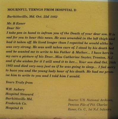
Union surgeons turned Burkittsville, a quiet rural village of some 200 people, into a hospital complex after the September 14, 1862, Battle of Crampton’s Gap. The building in front of you, the German Reformed Church, was Hospital D. . . . — — Map (db m190155) HM
Captain R. Preston Chew organized Chew’s Ashby Artillery, the first “horse artillery” in the Confederate army, in November 1861. He named it for Colonel Turner Ashby. Chew’s battery boasted a 3 in ordinance rifle, a 12-pounder smoothbore . . . — — Map (db m168571) HM
The first settlers in this area cleared their farm land and raised their families along two Indian trails that crossed here. Joshua Harley, one of these pioneers and a veteran of the American Revolution, started the settlement’s first dry goods . . . — — Map (db m190153) HM
Just before the Confederate line along Mountain Church Road gave way, Brigadier General Howell Cobb arrived in Crampton’s Gap with his Georgia and North Carolina troops. After meeting with Colonel Thomas Munford, who had been directing the battle, . . . — — Map (db m2060) HM
The Battle of South Mountain struck Crampton’s Gap late in the afternoon of September 14, 1862, when Union Gen. William B. Franklin finally ordered an attack against Confederate Gen. Lafayette McLaws’s force here. As the Confederate defensive line . . . — — Map (db m1909) HM
Fresh from victory at the Second Battle of Manassas, Gen. Robert E. Lee’s Army of Northern Virginia crossed the Potomac River on September 4-6, 1862, to bring the Civil War to Northern soil and to recruit sympathetic Marylanders. Union Gen. George . . . — — Map (db m1958) HM
None of the structures you see here in Crampton’s Gap existed during the battle on September 14, 1862. George Alfred Townsend constructed all the stone buildings and walls, as well as the Correspondents’ Arch, between 1884 and 1896. Townsend, . . . — — Map (db m1931) HM
Cobb’s Brigade McLaw’s Division C.S.A. ——•••—— At 1 P.M. on September 14, 1862, Cobb’s Brigade under Gen. Howell Cobb of Athens, GA. marched from Sandy Hook to Brownsville at the west foot of . . . — — Map (db m1964) HM
U. S. A. Sixth Army Corps. Major Gen. W. B. Franklin, Commanding (September 14, 1862) The Sixth Corps consisted of two Divisions commanded by Major Generals H. W. Slocum and W. F. Smith. On the march of the Army of the Potomac through Maryland, . . . — — Map (db m2024) HM
(September 14, 1862) Upon the approach of the Sixth Corps, Army of the Potomac, from Jefferson, Col. T. T. Munford, Commanding Cavalry Brigade, prepared to dispute its advance through this Pass. Mahone’s Brigade, Lt. Col. Parham, Commanding, was . . . — — Map (db m2023) HM
C. S. A. Maj. Gen. Lafayette McLaws' Command (September 12-13, 1862) McLaws’ Command consisted of Kershaw’s, Barksdale’s, Semmes’ and Cobb’s Brigades of his own Division and R. H. Anderson’s Division of six Brigades-Wilcox’s, Mahone’s, . . . — — Map (db m2021) HM
Between September 4th and 7th, 1862, the Army of Northern Virginia, General Robert E. Lee, Commanding, crossed the Potomac near Leesburg, and occupied Frederick, Maryland. On the 10th a movement was made to surround and capture the Union forces at . . . — — Map (db m2020) HM
In September, 1862, after the second Battle of Manassas, Gen. Robert E. Lee led his victorious Confederates on their first invasion of the North. At Frederick, Md. he boldly divided his army. Three columns (No. 1) were to surround and capture the . . . — — Map (db m2032) HM
1st, 2nd, 3rd, 4th Infantry and Hexamer’s Battery
September 14, 1862
Late in the afternoon the brigade advanced from the fields north and west of Burkittsville, charged up the mountain, carried this point and followed the enemy to the . . . — — Map (db m2061) HM
Organized in 1858 as the National Artillery, this unit changed its name to the Troup Light Artillery in honor of the former Georgia governor George W. Troup. It became a part of Cobb’s Legion when the war began. During the Maryland Campaign, the . . . — — Map (db m2143) HM
On the evening of September 13, 1862, Confederate cavalry under Brigadier General Wade Hampton and Colonel Thomas Munford occupied the Crampton’s Gap/Burkittsville vicinity. Early on the 14th, Major General J.E.B. Stuart, en route to Harpers Ferry, . . . — — Map (db m2150) HM
On September 14, 1862, this area was an open field belonging to George W. Padgett. A wooden, rail fence lined the road on the east. A low, stone wall bordered the field to the west. As the shattered remnants of Brigadier General Howell Cobb’s force . . . — — Map (db m2144) HM
In July 1862 Congress authorized the president to present medals to soldiers of the United States Army for gallant and meritorious service. On September 14, 1862, two soldiers so distinguished themselves during the fighting at Crampton’s Gap that . . . — — Map (db m2152) HM
The treatment of soldiers killed in action depended on which army held the battlefield after the guns fell silent. At South Mountain a few men from each Union regiment were assigned to burial details. To prevent the spread of disease, they lined up . . . — — Map (db m2145) HM
Colonel Joseph J. Bartlett, the Commander of the Second Brigade of Franklin’s First Division, found himself in a curious position. As a brigade commander, Bartlett chose both the field across which Franklin’s Corps would attack and the formation . . . — — Map (db m2151) HM
(Left Side) On September 4, 1862, General Robert E. Lee, hoping to shorten the war by winning a decisive victory on Northern soil, crossed the Potomac River into Maryland. Lee planned to draw the Army of the Potomac through South Mountain into . . . — — Map (db m2039) HM
(Front Side): The Mell Rifles, Co. D, Cobb’s Legion Infantry, was raised in Athens, GA. in July 1861, by Patrick Hues Mell, Baptist minster and Vice Chancellor of the University of Georgia. After Mell resigned due to his wife’s death, . . . — — Map (db m2044) HM
George Alfred Townsend, known by his pen name of “GATH,” was born in Georgetown, Delaware, in 1841. One of the youngest and most renowned special correspondents of his time, he reported on politics and war in both the . . . — — Map (db m2038) HM
General Robert E. Lee directed Major General Lafayette McLaws to close in on the Federal garrison at Harper’s Ferry via Elk Ridge, west of South Mountain. McLaws’ route from Frederick took him through Middletown, where he turned southwest on the . . . — — Map (db m153126) HM
An important part of the Battle of South Mountain was fought here September 14-15, 1862, when the Federal forces pressed back the Confederate troops into Pleasant Valley and to Sharpsburg. — — Map (db m144954) HM
Driven from Crampton’s Gap on Sept. 14, 1862, by Gen. Franklin’s Sixth Corps, elements of McLaws’ Confederates formed across Pleasant Valley to bar Union advance on Maryland Heights and Harper’s Ferry. Later these Confederates joined Lee about . . . — — Map (db m158372) HM
Marching from Middletown to seize Maryland Heights, McLaws’ and Anderson’s Confederate Divisions crossed South Mountain by this road September 11, 1862. On September 14th Manly’s N.C. Battery and elements of Semmes’ Brigade defended the pass and . . . — — Map (db m144952) HM
During the civil war, St. Luke’s served as headquarters for General Lafayette McLaws, whose troops from the Army of Northern Virginia were bivouacked around Brownsville, September 11, 1862. It served as a hospital for his wounded following the . . . — — Map (db m144951) HM