The Last Two American Forts
In 1798, Col. Thomas Hunt began construction on this site of the second American fort at the Three Rivers. this fort, which was completed in 1800, replaced the first, hastily built one erected nearby to the . . . — — Map (db m21219) HM
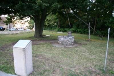
The "Old Well," an important factor in the existence of the fort and its people, saved the fort from Indian fire brands in 1812. Fort Wayne was first built, near by, in 1794. It was rebuilt, on this site, in 1804, and 1815.
Research by . . . — — Map (db m21210) HM
[Front Side of Marker]: "Tale of Ensign James Liggett"
After American militia troops forcibly ended the 1812 siege of Fort Wayne, General James Winchester's Army of the Northwest marched down the north side of the Miami [Maumee] . . . — — Map (db m28336) HM
"Spemica Lawba-Johnny Logan"
In September 1786, Captain Benjamin Logan of Kentucky captured a young Indian boy during a raid across the Ohio River on the Machachac tribe towns of the Shawnee nation. Upon returning to Kentucky, Captain Logan . . . — — Map (db m28338) HM
[Front Text] : "Fort Winchester"
General William Henry Harrison ordered the construction of Fort Winchester at the beginning of October 1812 and it was completed October 15. The fort served as a forward observation post and supply . . . — — Map (db m37974) HM
Built by General Wm. H. Harrison in Oct. 1812 and named for General Winchester.
For a time it was the only defensive work against the British and Indians in Northwestern Ohio. — — Map (db m18717) HM
Coohcooche
Mineral Spring 1790
Birthplace of Ottawa
Chief Shabonee 1775
and
Lodge of Shawnee Chief
Blue Jacket 1792
Winchester Camp No 1
1812
[Second Marker]
Chief
Blue Jacket . . . — — Map (db m28354) HM
[Front Text] : "Winchester's Camp No. 3/Fort Starvation"
Camp No. 3 was located about six miles below Fort Winchester on the north side of the Maumee River. Militiamen from Kentucky, part of the forces led by War of 1812 Brig. Gen. . . . — — Map (db m37924) HM
[Marker Front]
Site of Battles of Jan. 18 - 22
Gen. Winchester in Command,
and River Raisin Massacre
Jan. 23, 1813
[Marker Reverse]
800 Americans under Cols.
Allen, Lewis and Wells
Fought desperately against . . . — — Map (db m20041) HM
When the War of 1812 began, LaPlaisance Bay settlement consisted of 14 homes along the creek. Medard LaBadie, considered a hero for his participation in the Battles of the River Raisin and those at Fort Meigs and Thames, was a French settler here. . . . — — Map (db m165272) HM
[Marker side facing south]
Describing the American victory of January 18, 1813, Capt. John McCalla of the 5th Kentucky, wrote: "I have seen the enemy, and I have seen him defeated. I have seen my fellow soldiers extended lifeless bloody . . . — — Map (db m20945) HM
Joseph Porlier Benac, Sandy Creek's first settler, was granted a tract of land here by the Potawatomi Indians Aug. 3, 1780. By the time of the War of 1812, sixteen homes lined the banks of the creek.
Retreating Indians swept through the . . . — — Map (db m27245) HM
From near this spot on Jan. 22, 1813, 525 British soldiers and Canadian militiamen from Fort Malden under Col. Henry Proctor and some 800 Indians under Chiefs Roundhead and Walk-In-The-Water launched a pre-dawn attack on the sleeping American camp a . . . — — Map (db m236279) HM
Elements of the U.S. 17th Infantry were camped in an open field just north of here when the British and Indians launched their surprise counterattack at dawn, January 22, 1813. The Americans held their ground here for 20 minutes before the Canadian . . . — — Map (db m20904) HM
In this vicinity and parallel to the driveway, a line of scattered human remains were detected in 2000, which may mark the main skirmish line of the 17th U.S. Infantry. The bodies of those killed lay exposed to the elements for some time after the . . . — — Map (db m20916) HM
British Artillery on January 22nd consisted of six small cannons, mostly 3-pounders, with some small howitzers. The artillery pieces were first positioned about 400 yards north of here, just south of Mason Run Creek. These were used to good effect . . . — — Map (db m169608) HM
In the temporary absence of Tecumseh, the Native-American allies of the British were led by Wyandot Chiefs Roundhead and Walk-in-the-Water. Besides the Wyandots, Native forces included warriors from the Shawnee, Potawatomi, Ottawa, Chippewa, . . . — — Map (db m21567) HM
Here, Francois Navarre, first white settler in Monroe, built his home. His 500 acre farm, acquired by deed from the Indians in 1785, afforded a center for the River Raisin colony, by 1790 an important frontier community.
Col. Navarre was friend . . . — — Map (db m20933) HM
First Indian
Grant of land to the
First White Settler
In Monroe
Col. Francis Navarre
1785
First White Child Born
In Monroe
Gen. Winchester's
Headquarters 1813. — — Map (db m20938) HM
Under attack by the British and Indians before dawn on Jan. 22, 1813, in the second Battle of the River Raisin, the U.S. 17th Infantry soon broke and fled south across the frozen river. Gen. James Winchester, the American commander, tried several . . . — — Map (db m20899) HM
The Second Battle of the River Raisin Jan. 22, 1813, found nearly 400 American soldiers caught in retreat down this old road to Ohio. Those few who made it to this point, over a mile south of their camp, were ambushed by hidden Indians. The 40 . . . — — Map (db m27294) HM
Col. Allen tried vainly to rally the retreating Americans at the second Battle of the River Raisin, Jan. 22, 1813. Exhausted and disabled by a thigh wound, he faced the pursuing Indians near here. The colonel desperately defended himself at . . . — — Map (db m236275) HM
Protected only by a picket fence, nearly 500 Kentucky militiamen fought off three British charges on their camp along the river and silenced the British cannon with their long rifles in the second Battle of the River Raisin, Jan. 22, 1813.
They . . . — — Map (db m27243) HM
On this property in 1812 was the trading post of John Anderson, famed Scottish pioneer of the River Raisin.
Anderson, Colonel of the Militia in 1812, was taken prisoner at Detroit, later escaped.
Mrs. Anderson, alone at the time of the . . . — — Map (db m236276) HM
In 1789, Heutrau Navarre, son of Detroit's Royal Notary, built this house, Michigan's oldest residence. Constructed of joined timbers, it is considered the best example of French colonial architecture in the state. Originally Navarre used it as a . . . — — Map (db m27316) HM
The American Capt. John Woolfolk hid in one of the French homes just east of here during the massacre at the River Raisin, Jan. 23, 1813. Indians searching the settlement found him. They claimed him as their prisoner and forced him to this spot. . . . — — Map (db m20882) HM
Captain Nathaniel G. T. Hart, brother-in-law of Henry Clay and inspector general of American Army of the Northwest under Harrison, was killed here during the massacre of the River Raisin January 22 - 23, 1813.
Captain Hart, wounded in battle, . . . — — Map (db m236278) HM
Here in the log house of Jean Baptiste Jereaume the Federal Court of the Erie District, Territory of Michigan, held its first session July 3, 1805. President Thomas Jefferson named Judge Augustus B. Woodward to preside.
Beginning in 1807 the . . . — — Map (db m20909) HM
In the words of Laurent Durocher, "after the defeat of Winchester, many of the inhabitants fled with their families to the frontier of Ohio. Others went to Detroit. The British made several attempts to persuade the Indians to destroy what was left . . . — — Map (db m20905) HM
Here were buried unidentified remains of victims of the River Raisin Massacre of 1813.
In 1872 surviving veterans of that war gathered in Monroe from Ohio and Kentucky. They headed a colorful civic pageant which halted solemnly at this spot . . . — — Map (db m237960) HM
This Monument is dedicated to the
Memory of the heroes who
Lost their lives in our country's defense,
in the
Battle and Massacre of the River Raisin,
January 22nd, and 23rd, 1813. — — Map (db m20937) HM