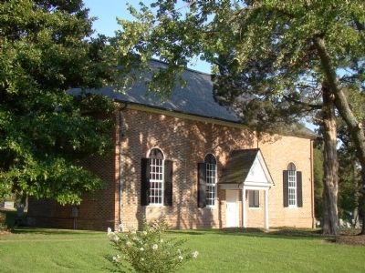
Near Lancaster in Lancaster County, Virginia — The American South (Mid-Atlantic)
St. Mary’s Whitechapel
Episcopal Church
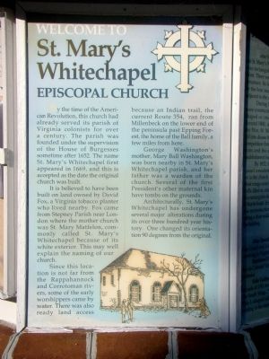
Welcome to St. Mary’s Whitechapel Episcopal Church.
By the time of the American Revolution, this church had already served its parish of Virginia colonists for over a century. The parish was founded under the supervision of the House of Burgesses sometime after 1652. The name St. Mary’s Whitechapel first appeared in 1669, and this is accepted as the date the original church was built.
It is believed to have been built on land owned by David Fox, a Virginia tobacco planter who lived nearby. Fox came from Stepney Parish near London where the mother church was St. Mary Matfelon, commonly called St. Mary’s Whitechapel because of its white exterior. This may well explain the naming of our church.
Since this location is not far from the Rappahannock and Corrotoman rivers, some of the early worshippers came by water. There was also ready land access because an Indian trail, the current Route 354, ran from Millenbeck on the lower end of the peninsula past Epping Forest, the home of the Ball family, a few miles from here.
George Washington’s mother, Mary Ball Washington, was born nearby in St. Mary’s Whitechapel parish, and her father was a warden of the church. Several of the first President’s other maternal kin have tombs on the grounds.
Architecturally, St. Mary’s Whitechapel has undergone several major alterations during its over three hundred year history. One changed its orientation 90 degrees from the original.
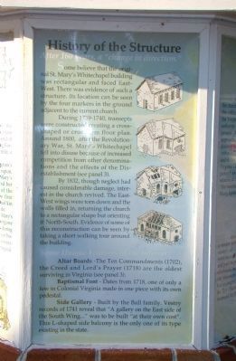
History of the Structure.
After 160 years, a “change in direction.” Some believe that the original St. Mary’s Whitechapel building was rectangular and faced East- West. There was evidence of such a structure. Its location can be seen by the four markers in the ground adjacent to the current church.
During 1739-1740, transepts were constructed treating a cross-shaped or cruciform floor plan. Around 1800, after the Revolutionary War, St. Mary’s Whitechapel fell into disuse because of increased competition from other denominations and the effects of the Disestablishment (see panel 3).
By 1832, though neglect had caused considerable damage, interest in the church revived. The East- est wings were torn down and the walls filled in, returning the church to a rectangular shape but orienting it North-South. Evidence of some of this reconstruction can be seen by taking a short walking tour around the building.
Some Unique Features of the Interior.
Altar Boards. The Ten Commandments (1702), the Creed and Lord’s Prayer (1718) are the oldest surviving in Virginia (see panel 3).
Baptismal Font. Dates from 1718, one of only a few in Colonial Virginia made in one piece with its own pedestal.
Side Gallery. Built by the Ball family. Vestry records of 1741 reveal that “A gallery on the East side of the South Wing...” was to be built “at their own cost.” This L-shaped side balcony is the only one of its type existing in the state.
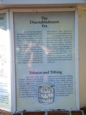
The Disestablishment Era.
Prior to the Revolution, the church of England had been the official state church of the Virginia colony under the authority of the House of Burgesses. As the Revolution approached, the church fell into disfavor because of its identification with the British Crown and its tax support. In 1802, the Virginia Legislature narrowly passed an Act allowing the seizure of church property for “the maintenance of the poor.” Many Episcopal churches fell into disuse. This period is known as the Disestablishment.
It took about 40 years for these bad feelings to abate and for the Episcopal church to become active again. Considerable church property was lost. Remarkably, even though St. Mary’s Whitechapel suffered considerable damage from neglect during this period, the original communion silver, dating from 1669, as well as the baptismal font and altar boards, survived.
Tobacco and Tithing.
Since this area was a major tobacco-producing center, all church expenses were accounted for and paid in pounds of tobacco, including the ministers’ salaries. For example, in 1776, the Rev. David Currie received 16,000-lbs. of tobacco for his services. Tithing required “processinors,” church members who visited a church member’s land and assessed the value of his property. When tithes were not paid voluntarily, it was not uncommon to employ the Sheriff’s help.
Topics. This historical marker is listed in these topic lists: Agriculture • Churches & Religion • Colonial Era • Settlements & Settlers. A significant historical year for this entry is 1652.
Location. 37° 44.828′ N, 76° 33.223′ W. Marker is near Lancaster, Virginia, in Lancaster County. Marker is at the intersection of River Road (Virginia Route 354) and White Chapel Road (Virginia Route 201), on the left when traveling north on River Road. Touch for map. Marker is at or near this postal address: 5940 White Chapel Rd, Lancaster VA 22503, United States of America. Touch for directions.
Other nearby markers. At least 8 other markers are within 5 miles of this marker, measured as the crow flies
. Queenstown (about 600 feet away, measured in a direct line); Trade Routes (approx. 2.8 miles away); St. Mary’s White Chapel (approx. 3.1 miles away); Birthplace of Washington’s Mother (approx. 3.7 miles away); Bewdley (approx. 3.8 miles away); Barford (approx. 4.4 miles away); Morattico Historic District (approx. 5.1 miles away); Major Edward Dale (approx. 5.1 miles away). Touch for a list and map of all markers in Lancaster.
Credits. This page was last revised on June 27, 2021. It was originally submitted on October 29, 2009, by J. J. Prats of Powell, Ohio. This page has been viewed 2,099 times since then and 53 times this year. Photos: 1, 2, 3, 4, 5. submitted on October 29, 2009, by J. J. Prats of Powell, Ohio.
