Dayton in Montgomery County, Ohio — The American Midwest (Great Lakes)
Mad River Road / Road From Cunningham's to Mad River
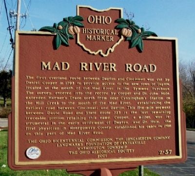
Side A: Mad River Road
The first overland route between Dayton and Cincinnati was cut by Daniel Cooper in 1795 to provide access to the new town of Dayton, located at the mouth of the Mad River in the Symmes Purchase. The survey, entered into the record by Cooper and Dr. John Hole, extended Harmer's Trace north from near Cunningham's Station on the Mill Creek to the mouth of the Mad River, establishing the earliest road between Cincinnati and Dayton. This five-mile segment between David Road and State Route 725 is the last remaining traceable portion retaining this name. Cooper, a miller, was instrumental in the early settlement of Dayton, and Dr. Hole, the first physician in Montgomery County, established his cabin in 1796 on this part of Mad River Road.
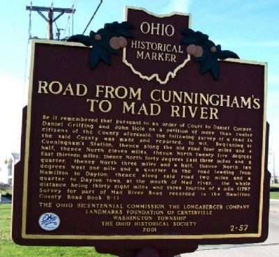
Side B: Road from Cunningham's to Mad River
Be it remembered that pursuant to an order of Court to Daniel Cooper, Daniel Griffing and John Hole on a petition of more than twelve citizens of the County aforesaid, the following survey of a road in the said County was made and reported, to wit, Beginning at Cunningham's Station, thence along the old road four miles and a half, thence North eleven miles, thence North twenty five degrees East thirteen miles; thence North forty degrees East three miles and a quarter, thence North three miles and a half, thence North ten degrees West one mile and a quarter to the road leading from Hamilton to Dayton; thence along said road two miles and a quarter to Dayton town, at the mouth of Mad river, the whole distance being thirty eight miles and three fourths of a mile. (1797 Survey for part of Mad River Road recorded in the Hamilton County Road Book B-1)
Erected 2001 by Ohio Bicentennial Commission, The Longaberger Company, Landmarks Foundation of Centerville-Washington Township and The Ohio Historical Society. (Marker Number 2-57.)
Topics and series. This historical marker is listed in these topic lists: Communications • Exploration • Industry & Commerce • Roads & Vehicles • Settlements & Settlers. In addition, it is included in the Ohio Historical Society / The Ohio History Connection series list. A significant historical year for this entry is 1795.
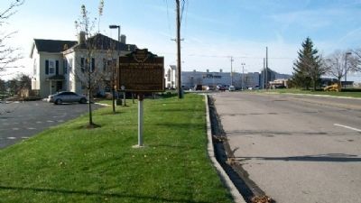
Location. 39° 38.212′ N, 84° 13.005′ W. Marker is in Dayton, Ohio, in Montgomery County. Marker is on Mad River Road, on the right when traveling north. Marker is adjacent to the parking lot behind the Dayton Mall Medical Arts Building. Touch for map. Marker is at or near this postal address: 2591 Miamisburg-Centerville Road (Ohio Route 725), Dayton OH 45459, United States of America. Touch for directions.
Other nearby markers. At least 8 other markers are within 4 miles of this marker, measured as the crow flies. Miamisburg
(approx. 1.9 miles away); Brigadier General Edmund Munger (approx. 2.6 miles away); Woody's Market (approx. 3 miles away); Centerville Veterans Memorial (approx. 3 miles away); Miamisburg Hillgrove Veterans Memorial (approx. 3.1 miles away); The Wright Seaplane Base / Wright Model G "Aeroboat" (approx. 3.1 miles away); Sugar Creek Baptist Church Cemetery (approx. 3.1 miles away); Wright Model G Seaplane (approx. 3.2 miles away).
Additional commentary.
1. Two identical markers
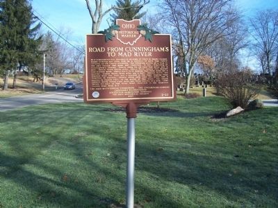
This is one of two identical markers, both on Mad River Road. the second is a little over three miles north, in David Cemetery. Both are in Kettering, Ohio. Both carry the number 2- 57.
— Submitted January 19, 2015, by Rev. Ronald Irick of West Liberty, Ohio.
Credits. This page was last revised on December 2, 2019. It was originally submitted on January 5, 2010, by William Fischer, Jr. of Scranton, Pennsylvania. This page has been viewed 1,888 times since then and 65 times this year. Photos: 1, 2, 3. submitted on January 5, 2010, by William Fischer, Jr. of Scranton, Pennsylvania. 4. submitted on February 24, 2015, by Rev. Ronald Irick of West Liberty, Ohio.


