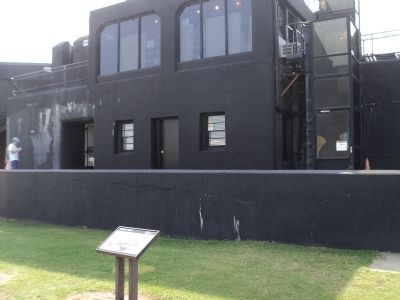
Battery Huger (ũ-jẽ) looms before you. Battery Huger, the black, concrete structure filling the center of Fort Sumter, was built in 1899 in response to the Spanish-American War. Named for Revolutionary War hero Isaac Huger, the battery . . . — — Map (db m30552) HM
On April 12, 1861, Confederate forces bombarded Fort Sumter and the Civil War began. The Federal garrison surrendered the next day and evacuated on the 14th, leaving the fort in Confederate hands. Throughout the Civil War Fort Sumter was the center . . . — — Map (db m30573) HM
The Fort Sumter that you see today bears little resemblance to the imposing, three tiered brick fort of 1861. The fort's present appearance is the result of more than 100 years of change. Bombardment, reconstruction, and renovation have reshaped the . . . — — Map (db m30624) HM
Imagine being here in 1863, surrounded by Fort Sumter's ruins, when this shell (photo below) explodes on the parade ground. Throughout the Civil War the fort was the center of the bitter conflict to control Charleston Harbor. For nearly two years . . . — — Map (db m30627) HM
The row of cannon in front of you dates from the Civil War, when radical advances in technology increased power, range, and accuracy. Some large, old smoothbore cannon were "rifled and banded" to enhance firepower. Banding (heating and tightening . . . — — Map (db m30639) HM
Designed by Thomas J. Rodman, U.S. Army Ordnance Officer, this type of cannon was the largest gun used in combat during the Civil War. These two Rodmans were brought to Fort Sumter as part of the 1870's modernization program. Tube Weight: 50,000 . . . — — Map (db m30641) HM
When the Confederates opened fire in April 1861, several 8-inch Columbiads were mounted in Fort Sumter. This weapon probably has remained here since then, weathering the Union bombardment of 1863 and the clean up of the 1870's. Archeological . . . — — Map (db m30646) HM
This 10-inch mortar, unearthed during the excavations in 1959, is similar to the one which fired the signal shot from Fort Johnson on April 12, 1861. Later in the war, the Confederate defenders of Fort Sumter mounted several of these weapons near . . . — — Map (db m30647) HM
A close look at the wall in front of you reveals Union artillery shells embedded in the brick. They were found during one of the longest sieges in U.S. military history. Batteries on Morris Island, about one mile behind you, and guns on Union . . . — — Map (db m30653) HM
The fort wall before you, called the right face, sustained the least damage of any of Fort Sumter's walls (scarps) during the Union bombardment of 1863-65. After the Civil War, the fort's first-tier casemates including those before you, were . . . — — Map (db m30673) HM
In front of you stands a rifled and banded columbiad cannon mounted as a mortar (aimed upward). It is mounted like the gun being inspected by a South Carolina delegation after the evacuation of Fort Sumter by Union troops in April 1861. The . . . — — Map (db m30675) HM
Discovered during the excavations of Fort Sumter, these rifled guns were installed by Federal troops during the 1870's modernization program. Maximum Range: 6800 yards (6218 M) — — Map (db m30679) HM
The Union Navy blockaded Charleston Harbor from 1861-65, but blockade runners continued to slip in and out, carrying cargo crucial to the economic and military survival of the South. Using neutral ports like Bermuda and Nassau, blockade runners . . . — — Map (db m30691) HM
On the night of February 17, 1864, the H.L. Hunley set out from Sullivan's Island, directly in front of you, with a torpedo attached to a seventeen-foot spar on her bow. Her target was the U.S.S. Housatonic, anchored four miles . . . — — Map (db m30699) HM
Confederate control of Fort Sumter, Fort Moultrie, and supporting fortifications kept Charleston Harbor open despite the blockade by Union ships. The main ship channel passed directly in front of you, between Fort Sumter and Fort Moultrie, within . . . — — Map (db m30702) HM
On April 7, 1863, the Union Navy sent its new force of ironclad warships - eight monitors and the frigate New Ironsides - to attack Fort Sumter. The ironclads attacked from the water directly in front of you. As the Union fleet approached, . . . — — Map (db m30708) HM
Morris Island, across the water directly in front of you, was the scene of the Civil War's first hostile cannon fire, preceding even the bombardment of Fort Sumter. By January 1861, Union troops occupying For Sumter were surrounded by Southern . . . — — Map (db m30724) HM
This corner of the fort was the site of the only attempt by Union forces to storm Fort Sumter during the Civil War. On the night of September 8, 1863, a Union tugboat towed 500 sailors and marines in small boats to within 400 yards of Fort Sumter, . . . — — Map (db m30725) HM
Confederates used several field pieces like this 12-pounder mountain howitzer to defend against a surprise landing by Union forces. — — Map (db m30739) HM
In honor of Major Robert Anderson and the one hundred, twenty-eight men of his command who for thirty-four hours: April Twelve-Thirteen, Eighteen hundred and Sixty-one withstood the destructive bombardment of Fort Sumter and withdrew with the . . . — — Map (db m87251) HM WM
Robert Parker Parrott designed the 6.4-inch, 8-inch and 10-inch Parrotts to serve on land or sea. These versatile rifled cannon were simple and inexpensive to construct. This gun, like many of the other weapons in Fort Sumter, was brought to the . . . — — Map (db m30764) HM
In 1861 the port of Charleston prospered. Keeping the city open to trade was crucial for Confederate survival. Confederate forts in Charleston Harbor - including Fort Sumter - protected Charleston throughout the war despite Union blockade, warship . . . — — Map (db m30769) HM
The First Shot Across the harbor directly in front of you lies Fort Johnson. From Fort Johnson came the shot that began the Civil War. If a Union soldier at Fort Sumter looked toward Fort Johnson at 4:30 a.m., April 12, 1861, he would have seen . . . — — Map (db m30785) HM
Confederate batteries hidden in the dunes of Morris Island, directly in front of you, commanded the approach to Charleston Harbor. Union forces needed Morris Island, a key location from which to attack Fort Sumter, less than one mile away. On July . . . — — Map (db m84003) HM
The flags flying from the five shorter flagpoles that surround the American flag represent the flags flown over Fort Sumter during the Civil War. (Top Left): The First official flag of the Confederacy, known as the "Stars and Bars," or . . . — — Map (db m30817) HM
Fort Moultrie and Fort Sumter controlled Charleston Harbor. Fort Moultrie, on Sullivan's Island directly in front of you, had been an early harbor defense and was the site of Charleston's famous Revolutionary War palmetto-log fort. Fort Sumter was . . . — — Map (db m30856) HM
Erected by the United States 1932 In memory of the Garrison Defending Fort Sumter during the bombardment April 12-14, 1861 Major Robert Anderson First U.S. Artillery commandingCorps of Engineers Captain John G. Foster 1st Lieut. George . . . — — Map (db m30916) HM
Fort Sumter was designed with its strength toward the sea. The gorge, the lightly-armed rear wall facing inland, was vulnerable to attack from Morris Island. Early shelling left the gorge wall in ruins. Continued bombardment reduced the gorge to . . . — — Map (db m30919) HM
Fort Sumter's powder was stored in these specially constructed rooms in the corner (angle) of the gorge wall. Protecting gunpowder was critical; the gorge, at the rear of the fort, was considered a safe location. But Fort Sumter was designed to face . . . — — Map (db m30920) HM
Load ... Ready ... Fire! A disciplined crew of five men could fire an accurate shot in less than one minute. Teamwork and timing during battle were essential to the crew of this 42-pounder smoothbore cannon, one of 27 guns that occupied these . . . — — Map (db m30922) HM
This concrete casemate was added to the fort in 1891. It was was the control room for an electrically operated minefield, which was placed in the main shipping channel to prevent the entrance of enemy vessels into the harbor. Long cables connected . . . — — Map (db m30935) HM
Fort Sumter's original sally port (entrance) was located in front of you, in the center of the three-tiered gorge (rear) wall. The lightly armed gorge wall was vulnerable to attack by batteries on Morris Island, and as the war progressed Union . . . — — Map (db m30936) HM