3 entries match your criteria.
Related Historical Markers
To better understand the relationship, study each marker in the order shown.
By Bill Kirchner, August 3, 2010
Roosevelt Dam Marker
SHOWN IN SOURCE-SPECIFIED ORDER
| |
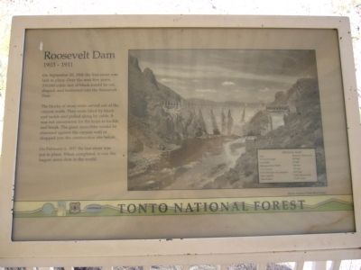
On September 20, 1906 the first stone was laid in place. Over the next five years, 350,000 cubic feet of block would be cut, shaped, and fashioned into the Roosevelt Dam.
The blocks of stone were carved out of the canyon walls. They were . . . — — Map (db m34106) HM |
| | The construction of Roosevelt Dam involved several thousand people over the course of the project. Hiring was straightforward; a foreman would simply size up a man and decide if he could do the work. Jobs requiring diverse skills were plentiful. . . . — — Map (db m34108) HM |
| |
After nearly nine years of work, $430 million in construction cost, 450,000 cubic yards of concrete, and 849 miles of reinforcing steel, another vivid chapter in Arizona history has been rewritten. Modifications to Roosevelt Dam were required . . . — — Map (db m34107) HM |
Apr. 25, 2024