Fort Washington Park is the site of the first permanent fort constructed between 1814-1824 to guard the Potomac River approach to our Nation's Capital. Today the park offers many recreational opportunities and programs. Explore the historic sites . . . — — Map (db m4554) HM
American coastal defenses were modernized from the 1890s to 1910 with the development of the Endicott System. Emphasis in military tactics shifted the masonry fortifications to more effective weapons based on rifled steel guns, improved . . . — — Map (db m7955) HM
Coastal fortifications moved into the 20th century with the development of the Endicott System. At Fort Washington, eight reinforced concrete batteries were constructed near the old fort to mount modern artillery. Many support buildings were . . . — — Map (db m46176) HM
Building the Second Fort On September 8, 1814, only 12 days after the destruction of Fort Warburton, Pierre L'Enfant was commissioned by the Government to reestablish a fortification here. Work began that October but increasing friction between . . . — — Map (db m7963) HM
Troubles with Britain caused Congress in 1807 to authorize an improved system of forts along the Atlantic Coast to guard harbors, rivers, and seaports. The first fort, Fort Warburton, was completed in 1809. Located near the river in front of the . . . — — Map (db m7980) HM
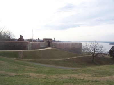
Two sets of gates protected the main entrance, or sally port. During the improvements made in the 1840s the drawbridge was added to make the approach to the gates more difficult. The drawbridge, operated by a unique system of iron counterweights . . . — — Map (db m7982) HM
During the 1840s improvements were made to this wall, defensively the weakest part of the fort. The parapet was raised and an outer work, called a caponiere, was added. The protected passageway on your left will lead you to the outerwork that . . . — — Map (db m8075) HM
A reliable supply of drinking water for the garrison was a priority at Fort Washington. Three wells dug early in the fort's construction proved inadequate. By 1823, four cisterns were installed to store rainwater. Located underground at each end of . . . — — Map (db m8071) HM
Along the outer wall of the ditch you see the counterscarp battery, named for its location on the "counterscarp," or outer wall, of the dry ditch. This structure sheltered troops who could direct musketry toward the river or into the ditch itself. . . . — — Map (db m8068) HM
Minefields were an important part of the Endicott System of defense at the turn of the century. You are standing on the site that controlled the minefield operation. Groups of underwater mines anchored in the river downstream from the fort could be . . . — — Map (db m8065) HM
Fort Washington's solid masonry walls offered good protection against shot from smoothbore cannon of the early 19th century. When rifled artillery was introduced in the late 1850s and used during the Civil War, effectiveness of masonry structures . . . — — Map (db m8063) HM
Construction of this inverted V-shaped outerwork began in 1814. Traces of its shape are visible today. Surrounded by a dry ditch, the Water Battery mounted 24-pounder guns that provided an additional level of firepower to the fort. The Water . . . — — Map (db m8061) HM
The demi-bastion is a section of the fort that projects beyond the main wall and provides concentrated defensive fire. The bastion design includes two levels of artillery. Guns were to be mounted on the parapet above and in the casemates you see . . . — — Map (db m7998) HM
Strategically placed, this permanent section of the fort was the lowest level of the three tiers of guns. The Water Battery was designed to deliver "water-skipping" cannonade directed at the hulls of enemy ships. The simple V-shaped design has . . . — — Map (db m8078) HM
Remnants of former gun emplacements are the reminders of the three generations of armaments that occupied this V-shaped Water Battery. Each generation reflects the latest technologies and precision in the manufacture of armaments. 1830 - The first . . . — — Map (db m8080) HM
Home of the Digges Family
(descendants of Edward Digges,
governor of Virginia, 1652–1668)
The most intimate friend of
George and Martha Washington
in Prince George’s County,
where they visited many times. . . . — — Map (db m3663) HM
(Left Panel): Three pair of these large 10-inch caliber disappearing guns were the key feature of the 1890s river defense system. Each weapon could direct its 650-pound projectile at enemy ships within a seven-mile range. Battery Humphries is . . . — — Map (db m8083) HM
Named Battery Meigs, these two pits contained eight large 12-inch mortars. Each huge mortar was capable of hurling a 700-pound projectile in a high arc. The simultaneous firing of all eight would insure a clustered group of shells falling on the . . . — — Map (db m8086) HM