7 entries match your criteria.
Related Historical Markers
To better understand the relationship, study each marker in the order shown.
By Bill Kirchner, January 1, 2010
Presidio Wall & Pithouse Marker
SHOWN IN SOURCE-SPECIFIED ORDER
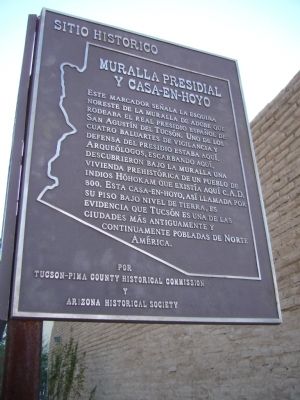
| | This marker locates the northeast corner of the adobe wall which surrounded the Royal Spanish Presidio San Agustin del Tucson. It is thought that a bastion, used as a lookout and as a defensive position, stood here. The site was excavated in 1954 by . . . — — Map (db m83213) HM |
| |
N.E. Corner
Adobe Wall of Spanish Presidio of Tucson
Marked 1926 by D.A.R. — — Map (db m26460) HM |
| | The first Pima County Courthouse, a single-story adobe structure built in 1868, was replaced in 1881 by a large two-story stone and red brick victorian building which, in turn, was removed in 1928 to make way for the present structure. This . . . — — Map (db m55222) HM |
| |
This disc marks the southeast corner of the old adobe wall that protected Tucson from the Indians in the early days - prior to 1845
Moved to this location in 1955 — — Map (db m26461) HM |
| | Near this site was the southwest corner of the adobe wall that surrounded the Spanish Presidio, an enclosure of 11 ¼ acres which included most of the present city – county governmental complex and the Art Museum block. Tucson was the largest . . . — — Map (db m83214) HM |
| | This marker locates the northwest corner of the adobe wall which surrounded the Royal Spanish Presidio San Agustín del Tucson. In 1776 the new outpost was garrisoned by seventy Spanish cavalry troopers and Indian scouts, transferred from . . . — — Map (db m83212) HM |
| |
N. W. Corner
Adobe Wall of Spanish
Presidio of Tucson
Marked 1926 by D.A.R. — — Map (db m26462) HM |
Apr. 24, 2024