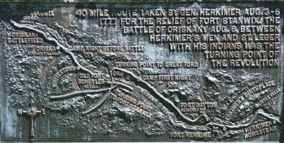
40 mile route taken by Gen. Herkimer Aug. 3-6, 1777 for the relief of Fort Stanwix. The Battle of Oriskany Aug. 6, between Herkimer's men and St. Leger with his Indians was the turning point of the Revolution.
From this point
General . . . — — Map (db m75330) HM WM
40 mile route taken by Gen. Herkimer Aug. 3-6, 1777 for the relief of Fort Stanwix. The Battle of Oriskany Aug. 6, between Herkimer's men and St. Leger with his Indians was the turning point of the Revolution.
To the memory of the men . . . — — Map (db m57308) HM
40 mile route taken by Gen. Herkimer Aug. 3-6, 1777 for the relief of Fort Stanwix. The Battle of Oriskany Aug. 6, between Herkimer's men and St. Leger with his Indians was the turning point of the Revolution.
Near this spot was the site . . . — — Map (db m57353) HM
40 mile route taken by Gen. Herkimer Aug. 3-6, 1777 for the relief of Fort Stanwix. The Battle of Oriskany Aug. 6, between Herkimer's men and St. Leger with his Indians was the turning point of the Revolution.
Here was born Nicholas . . . — — Map (db m57358) HM
40 mile route taken by Gen. Herkimer Aug. 3-6, 1777 for the relief of Fort Stanwix. The Battle of Oriskany Aug. 6, between Herkimer's men and St. Leger with his Indians was the turning point of the Revolution.
At Fort Dayton, near this . . . — — Map (db m54261) HM
40 mile route taken by Gen. Herkimer Aug. 3-6, 1777 for the relief of Fort Stanwix. The Battle of Oriskany Aug. 6, between Herkimer's men and St. Leger with his Indians was the turning point of the Revolution.
General Herkimer
camped near . . . — — Map (db m54257) HM
40 mile route taken by Gen. Herkimer Aug. 3-6, 1777 for the relief of Fort Stanwix. The Battle of Oriskany Aug. 6, between Herkimer's men and St. Leger with his Indians was the turning point of the Revolution.
At this point,
On August 5, . . . — — Map (db m32452) HM
40 mile route taken by Gen. Herkimer Aug. 3-6, 1777 for the relief of Fort Stanwix. The Battle of Oriskany Aug. 6, between Herkimer's men and St. Leger with his Indians was the turning point of the Revolution.
1500 feet east of this spot . . . — — Map (db m54245) HM
40 mile route taken by Gen. Herkimer Aug. 3-6, 1777 for the relief of Fort Stanwix. The Battle of Oriskany Aug. 6, between Herkimer's men and St. Leger with his Indians was the turning point of the Revolution.
The site of Old Fort . . . — — Map (db m54256) HM
40 mile route taken by Gen. Herkimer Aug. 3-6, 1777 for the relief of Fort Stanwix. The Battle of Oriskany Aug. 6, between Herkimer's men and St. Leger with his Indians was the turning point of the Revolution.
General Herkimer . . . — — Map (db m242485) HM
40 mile route taken by Gen. Herkimer Aug. 3-6, 1777 for the relief of Fort Stanwix. The Battle of Oriskany Aug. 6, between Herkimer's men and St. Leger with his Indians was the turning point of the Revolution.
On August 5, 1777
leading . . . — — Map (db m32430) HM
40 mile route taken by Gen. Herkimer Aug. 3-6, 1777 for the relief of Fort Stanwix. The Battle of Oriskany Aug. 6, between Herkimer's men and St. Leger with his Indians was the turning point of the Revolution.
The rear guard of
General . . . — — Map (db m32442) HM
40 mile route taken by Gen. Herkimer Aug. 3-6, 1777 for the relief of Fort Stanwix. The Battle of Oriskany Aug. 6, between Herkimer's men and St. Leger with his Indians was the turning point of the Revolution.
Near this spot
on the night . . . — — Map (db m65974) HM
40 mile route taken by Gen. Herkimer Aug. 3-6, 1777 for the relief of Fort Stanwix. The Battle of Oriskany Aug. 6, between Herkimer's men and St. Leger with his Indians was the turning point of the Revolution.
Near this spot
Stood the . . . — — Map (db m32062) HM