3 entries match your criteria.
Related Historical Markers
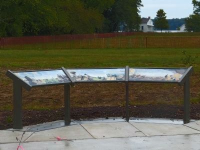
These three markers jointly tell the history of Jones Point.
By Allen C. Browne, October 7, 2012
This Marker is the first (leftmost) of three markers in this location.
SHOWN IN SOURCE-SPECIFIED ORDER
| | Jones Point was once a wooded wilderness, ringed by marshes and periodically cut off from the mainland during high tide. American Indians made use of both woodland and wetland for food, tools and supplies. By the 17th century, Europeans had . . . — — Map (db m62028) HM |
| | From the late 1700s into the 1800s, the pastoral calm of the Point was interrupted repeatedly—by soldiers manning cannon emplacements, by surveyors laying out the boundaries of the nation's capital, by workers at a ropewalk and the lighthouse, . . . — — Map (db m62029) HM |
| | In the 20th century, Jones Point continued to be shaped by the changing needs of the federal government. With proximity to the capital and access to land and river transportation, the peninsula was chosen as the site for several military . . . — — Map (db m62030) HM |
Apr. 24, 2024