3 entries match your criteria.
Related Historical Markers
To better understand the relationship, study each marker in the order shown.
By Dale K. Benington, March 9, 2013
Tel Afeq - Antipatris Marker
SHOWN IN SOURCE-SPECIFIED ORDER
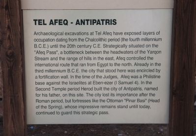
| | Archaeological excavations at Tel Afeq have exposed layers of occupation dating from the Chalcolithic period (the fourth millennium B.C.E.) until the 20th century C.E. Strategically situated on the "Afeq Pass", a bottleneck between the headwaters . . . — — Map (db m64309) HM |
| | A remnant of the main street of the Roman city of Antipatris. "Cardo" is the name for the main north-south street of a Roman-era city. Shops lined the Cardo, and at its center it was connected to the Forum, the city's central square. Grooves can be . . . — — Map (db m64445) HM |
| | This is the most complete of the six Late Bronze Age (Canaanite), 1550-1200 B.C.E. palaces excavated at Afeq. The ground floor is preserved in its entirety, while the stairway testifies to the existence of the now-destroyed upper storeys. . . . — — Map (db m64406) HM |
Apr. 19, 2024