5 entries match your criteria.
Related Historical Markers
The list includes other historical markers about the Chicago Road in Michigan.
By R. C., May 3, 2011
Chicago Road Marker
SHOWN IN SOURCE-SPECIFIED ORDER
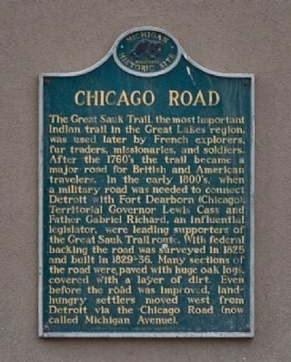
| | The Great Sauk Trail, the most important Indian trail in the Great Lakes region, was used later by French explorers, fur traders, missionaries, and soldiers. After the 1760's the trail became a major road for British and American travelers. In the . . . — — Map (db m42298) HM |
| | Conrad Ten Eyck (1782-1847) built a famous tavern in 1826 about 300 feet west of this marker--the first resting place of travelers, one day's trip west of Detroit. It stood on the River Rouge at a point where the Chicago Road forked. The northerly . . . — — Map (db m32498) HM |
| |
Side 1
In 1839 Wayne County purchased the Black Horse Tavern, a stagecoach stop, Located here on the Chicago road, for use as a poorhouse. Early on the poorhouse accepted not only the county's indigent, but the infirm and mentally ill . . . — — Map (db m170060) HM |
| |
(Front Side)
The Great Sauk Trail, which connected Detroit, Chicago and Green Bay, Wisconsin, crossed the St. Joseph River at a shallow spot in this vicinity. Responding to the westward migration of pioneers, the federal government . . . — — Map (db m64545) HM |
| | Nearby French and English trading posts were known as parc aux vaches or “cowpens” for the wild buffalo once found here. Joseph Bertrand, an early trader, married the daughter of a Potawatomi chief and through her acquired land in . . . — — Map (db m1604) HM |
Apr. 19, 2024