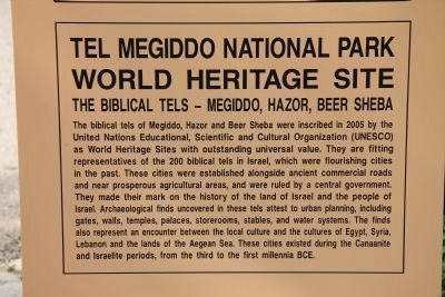
The biblical tels of Megiddo, Hazor and Beer Sheba were inscribed in 2005 by the United Nations Educational, Scientific and Cultural Organization (UNESCO) as World Heritage Sites with outstanding universal value. They are fitting representatives of . . . — — Map (db m64811) HM
The city of Megiddo played a prominent role in the history of the ancient Near East. Strategically located at the mouth of the Nahal Iron Pass, Megiddo controlled access to the road that linked Egypt with Mesopotamia and Anatolia - the most . . . — — Map (db m64782) HM
[Text on the Left Side of the Marker]:
The Late Bronze period (1550-1150 B.C.) is marked by Egyptian rule of Canaan. At that time, Megiddo was one of the country's major city-states and its king a loyal vassal of the Egyptian pharaoh. . . . — — Map (db m64821) HM
[Text on the Left Side of the Marker]:
Megiddo became an Israelite city sometime between the 10th and 9th centuries B.C., and functioned as an administrative center for he fertile Jezreel Valley. Some time later, a massive wall (1) and a . . . — — Map (db m64882) HM
[Text on the Left Side of the Marker]:
Architectural complexes dating from the same period (9th or 8th c. B.C.) and of similar design were found near the northern and southern edges of the mound. Through the years they variously . . . — — Map (db m64889) HM
[Text on the Left Side of the Marker]:
The foundations of this palace, first investigated by Y. Yadin in 1960, are presently being excavated by 'The Megiddo Expedition'. The edifice was apparently laid out as a bit hilani (North . . . — — Map (db m64898) HM
[Text on the Left Side of the Marker]:
The deep section dug by the University of Chicago Expedition (1925-1939) provides a unique glimpse into the nearly thirty settlements built one on top of the other at the site. Due to the unique . . . — — Map (db m64908) HM
[Text on the Left Side of the Marker]:
This area served as a focus of worship for over two thousand years, from the Early Bronze through the Iron I periods. The University of Chicago excavation section a series of temples (1, 3-5) built . . . — — Map (db m64985) HM
The first excavations at Tel Megiddo were directed by Gottlieb Schumacher on behalf of the Deutscher Palastina-Verein, between 1903 and 1905. After excavating the Tempelburg ('temple-fortress') in the eastern section of the mound, . . . — — Map (db m65019) HM
A public grain silo from the time of King Jeroboam II (8th century BCE). The silo had a capacity of 450 cubic meters. Straw found between the stones attests to the function of the installation. — — Map (db m65196) HM
[Text on the Left Side of the Marker]:
An elaborate ashlar-built palace (1) stood near the southern edge of the mound. A monumental entrance (2) - the only visible remains still standing - led to the courtyard (3). Like the northern . . . — — Map (db m65198) HM
[Text on the Left Side of the Marker]:
The southern stables' five units could accommodate 150 horses. As in the northern complex, each unit consists of a rectangular building divided into three sections by two rows of alternating pillars . . . — — Map (db m65204) HM
[Text on the Left Side of the Marker]:
The problem of supplying water to large cities, a serious issue even in times of peace, could become acute in times of siege. Megiddo's main water source was located at the foot of the mound, beyond . . . — — Map (db m65215) HM