Ottawa in Franklin County, Kansas — The American Midwest (Upper Plains)
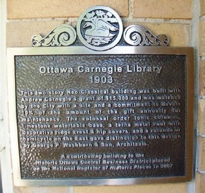
Ottawa Carnegie Library
1903
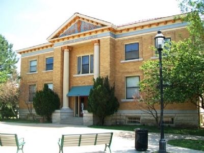
This two story Neo-Classical building was built with Andrew Carnegie's grant of $15,000 and was matched by the City with a site and a commitment to devote 10% of the amount of the gift annually for maintenance. The colossal order Ionic columns, limestone watertable base, a terne metal roof with decorative ridge crest & hip covers, and a rotunda or hemicycle on the East gave distinction to this design by George P. Washburn & Son, Architects.
A contributing building to the Historic Ottawa Central Business District placed on the National Register of Historic Places in 2007
Topics and series. This historical marker is listed in these topic lists: Architecture • Charity & Public Work • Education. In addition, it is included in the Carnegie Libraries series list. A significant historical year for this entry is 2007.
Location. 38° 36.652′ N, 95° 16.087′ W. Marker is in Ottawa, Kansas, in Franklin County. Marker is on Main Street south of 5th Street, on the left when traveling south. Touch for map. Marker is at or near this postal address: 501 South Main Street, Ottawa KS 66067, United States of America. Touch for directions.
Other nearby markers. At least 8 other markers are within walking distance of this marker. Civil War Memorial (within shouting distance of this marker); Dietrich Cabin, 1859 (within shouting distance of this marker); Main Street, 500 Block South and City Park (about 300 feet away, measured in a direct line); Main Street, 400 Block South (approx. 0.2 miles away); The Franklin County Courthouse (approx. 0.2 miles away); a different marker also named Franklin County Courthouse (approx. ¼ mile away); The Down Town Ottawa Historic District (approx. 0.3 miles away); Pickrell Building (approx. 0.3 miles away). Touch for a list and map of all markers in Ottawa.
Also see . . .
1. Historic Ottawa Central Business District National Register Nomination. (Submitted on August 9, 2013, by William Fischer, Jr. of Scranton, Pennsylvania.)
2. Carnegie Libraries: The Future Made Bright. National Park Service entry (Submitted on August 9, 2013, by William Fischer, Jr. of Scranton, Pennsylvania.)
3. Carnegie Collections at Columbia University. (Submitted on August 9, 2013, by William Fischer, Jr. of Scranton, Pennsylvania.)
Credits. This page was last revised on December 17, 2020. It was originally submitted on August 9, 2013, by William Fischer, Jr. of Scranton, Pennsylvania. This page has been viewed 441 times since then and 20 times this year. Photos: 1, 2. submitted on August 9, 2013, by William Fischer, Jr. of Scranton, Pennsylvania.

