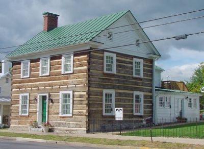
On Congress Street (U.S. 11) at Breckinridge Lane, on the right when traveling south on Congress Street.
The old home of William F. Rupp who was one of the Valley's most skilled fresco painters. In the Rupp house also lived George M. Neese, the author of “Three Years in the Confederate Horse Artillery.” Descendants still own and occupy the . . . — — Map (db m558) HM
On Main Street (U.S. 11) at Nelson Street (Local Route 1314), on the right when traveling north on Main Street.
The Confederate hospital was built here under the direction of Dr. Andrew Russell Meem, by order of the Confederate Medical Department in Sept. 1861. The hospital consisted of three two-story buildings, each 150 feet long, accommodating 500 . . . — — Map (db m156948) HM
On Main Street (U.S. 11) south of Nelson Street (Local Route 1314), on the left when traveling north.
The Mount Jackson Confederate Hospital’s cemetery,
now called Our Soldiers Cemetery, was dedicated on May 10, 1866 the third anniversary of Stonewall Jackson’s death. The “Memorial and Decoration Day” organized by the local ladies was . . . — — Map (db m156950) HM
On East King Street (Virginia Route 55) 0.1 miles east of Acton Place, on the right when traveling east.
The railroad tracks before you follow the route of the Manassas Gap Railroad, which reached Strasburg from Washington, D.C., in 1854. The line was a vital link between the Shenandoah Valley and eastern markets. Strasburg became strategically . . . — — Map (db m2323) HM
On Main Street (U.S. 11) south of Nelson Street (Local Route 1314).
The Confederate Hospital was established at Mount Jackson under the direction of Dr. Andres Russell Meem by order of the Confederate Medical Department in Richmond, Virginia about September 15, 1861. Dr. Meem, a native of the area, was a graduate of . . . — — Map (db m156952) HM
On East King Street (Virginia Route 44), on the left when traveling west.
Jackson captured engines from Martinsburg, W.VA. and had them pulled by horse teams across the roads to Strasburg, near here, they were set on rails and sent south for the Confederate cause. — — Map (db m15542) HM
On Valley Pike (U.S. 11) 0.4 miles north of Quarry Road, in the median.
Just west of modern route 11 is the Daniel Stickley Farm. The ruins of the Stickley Mills are located beside the creek just below the house. During the war, the Valley Turnpike ran past the brick Stickley house and turned right onto a covered bridge . . . — — Map (db m644) HM
Near Main Street (U.S. 11) near Daniel Grey Street.
Built through the efforts of Mrs. William Steenbergen, the church has served as a meeting place for Mt. Jackson churches. The cemetery represents a history of the town and its early citizens. Daniel Grey, a Revolutionary War soldier, is buried in . . . — — Map (db m156955) HM
On Old Valley Pike (U.S. 11) south of Caverns Road at Exit 269 (Interstate 81), on the right when traveling south.
Stonewall Jackson’s camp ground April 2–16, 1862; his headquarters at the foot of this hill. Colonel John Francis Neff, Commander 33rd Regiment, Stonewall Brigade, born and buried near here. — — Map (db m740) HM
On Old Valley Pike (U.S. 11) south of Caverns Road at Exit 269 (Interstate 81), on the right when traveling south.
This old house photographed during the early 20th century and still standing about 600 yards north on the west side of the Valley Pike, was occupied
at the beginning of the Civil War by a Lutheran minister, Rev. Anders R. Rude. Gen. Thomas J. . . . — — Map (db m836) HM
On West Washington Street at North Fort Street, on the right when traveling west on West Washington Street.
Historic valley congregation, strasburg's oldest, organized by German settlers (c.1747) who first worshiped in log building just west of this site. Parish records date from 1769. Strasburg's first school conducted by the congregation and its . . . — — Map (db m3468) HM
On East Washington Street at North Holiday Street, on the right when traveling east on East Washington Street.
In the spring of 1862, U.S. Army Capt. Edward Hunt, an engineer, constructed a fortification on the hill where the Strasburg water tower now stands. Hunt selected the hill "because it had an effective command over the roads, the railroad, and the . . . — — Map (db m9546) HM
On Lee Highway (U.S. 211) 0.1 miles west of Crisman Hollow Road, on the right when traveling east.
Having remained with his command
in the vicinity of Winchester since the
Battle of Sharpsburg/Antietam, by
November 22, 1862, Gen. Thomas J.
“Stonewall” Jackson was again on
the march. With more than 32,000
soldiers, Jackson’s force made . . . — — Map (db m16453) HM
On Old Valley Pike (U.S. 11) near Caverns Road at Exit 269 (Interstate 81), on the right when traveling south.
On 15 Nov. 1863, Col. William H. Boyd reconnoitered with a Federal cavalry and artillery detachment south from Charlestown (in present-day W.Va.) toward New Market. The next day, the force encountered Maj. Robert White’s cavalry command just north . . . — — Map (db m157057) HM
On Old Valley Turnpike (U.S. 11) north of New Market.
Erected to the memory of the heroic dead of the 54th Regiment, Pennsylvania Veterans Volunteer Infantry, who gave their lives in defence of their country. 1861–1865.
(brass tablet at base) At ceremonies conducted 16 September . . . — — Map (db m42449) WM
On George Collin Parkway aka Miller Lane (Virginia Route 305) near Interstate 81, exit 264 west (U.S. 211), in the median.
The Battle of New Market was fought here Sunday morning, May 15, 1864. The Confederates under Gen. J. C. Breckinridge were victorious over the Federals under Gen. Franz Sigel. The decisive incident of the battle was the heroic capture of the Federal . . . — — Map (db m182592) HM
On Old Valley Turnpike (U.S. 11) north of New Market, on the right when traveling south.
General U.S. Grant's plan to defeat the Confederacy in 1864, called for a raid by General G. Crook into southwestern Virginia. General F. Sigel, to keep the Confederates from concentrating against Crook, was to advance down Shenandoah Valley from . . . — — Map (db m201543) HM
On Old Valley Pike (U.S. 11) north of New Market, on the right when traveling south.
On the hills to the north took place the Battle of New Market, May 15, 1864. The Union army, under General Franz Sigel, faced southwest. John C. Breckinridge, once Vice-President of the United States, commanded the Confederates. Colonel Scott Shipp . . . — — Map (db m554) HM
On Congress Street (U.S. 11) at Breckinridge Lane, on the right when traveling south on Congress Street.
This very post was struck by a 3 inch rifle shell fired by Snow’s Maryland Battery in the Battle of New Market fought between General John C. Breckinridge and General Franz Sigel on the 15th of May 1864. When the shell struck, General Breckinridge . . . — — Map (db m223940) HM
On Old Valley Pike (U.S. 11) south of Caverns Road at Exit 269 (Interstate 81), on the right when traveling south.
1864 Valley Campaign. The spring of 1864 opened with United States forces pressing Confederate armies defending fronts scattered throughout the Confederacy. Union Gen. Franz Sigel was assigned the task of securing the Shenandoah Valley; always . . . — — Map (db m837) HM
On Old Valley Pike (U.S. 11) south of Smith Creek Road (Local Route 620), on the right when traveling south.
Here Capt. Henry DuPont, commanding B Battery, 5th U.S. Artillery, protected Union Gen. Franz Sigel’s defeated army as it retreated after the Battle of New Market on May 15, 1864. Confederate Gen. John C. Breckinridge had routed Sigel’s force . . . — — Map (db m838) HM
Near George Collin Parkway (Virginia Route 305) at West Old Cross Road (U.S. 211).
In 1875, Confederate veteran Christian Shirley constructed this brick house on the site of his family's former home, which had burned two years earlier. The Shirleys were longtime residents of Shenandoah County who had farmed their 153 ares since . . . — — Map (db m7346) HM
Near George Collin Parkway (County Route 305), on the right when traveling south.
While the cadets of the Virginia Military Institute comprised one of the smallest Confederate units engaged in the Battle of New Market, they paid a disproportionately high price in their baptism of fire. Nearly one in four of the cadets were . . . — — Map (db m13186) HM
Near George Collin Parkway (County Route 305), on the right when traveling south.
On June 22, 1791, Henry Bushong patented a 260-acre tract in Shenandoah County that would be home for several generations of his descendants. Henry’s son, Jacob married Sarah Strickler in 1818. They took up residence in a four-room log house and . . . — — Map (db m165232) HM
Near George Collin Parkway (County Route 305), on the right when traveling south.
In front of you is one of only two monuments erected by veterans of the battle. This one was placed by members of Woodson’s Company of Missouri Cavalry. The unit followed perhaps the strangest path to this field of conflict.
Captured in . . . — — Map (db m13197) HM
Near George Collin Parkway (County Route 305), on the right when traveling south.
The main Union line of battle extended from here for one-half mile to the Valley Turnpike, now U.S. 11. Throughout the morning and into the afternoon, the Union force exchanged musket and cannon fire with the Confederates, who had advanced over a . . . — — Map (db m13203) HM
On Old Valley Pike (U.S. 11), on the right when traveling south.
September 22, 1864 General Philip Sheridan with 30,000 Federals defeated General Jubal Early with 11,000 Confederates. Driven in route from Winchester September 19, by Sheridan's overpowering numbers, Early formed his line of battle across the . . . — — Map (db m4139) HM
On Old Valley Pike (U.S. 11), on the right when traveling south.
After his defeat on 19 Sept. 1864 at the Third Battle of Winchester by Maj. Gen. Philip H. Sheridan, Lt. Gen. Jubal A. Early led his 9,500-man army here to Fisher's Hill, a favorite Confederate stronghold. Sheridan pursued, and on 22 Sept. attacked . . . — — Map (db m50313) HM
On Old Valley Pike (U.S. 11) at Millner Road (County Route 644), on the right when traveling north on Old Valley Pike.
Here Early's Adjutant-General, A.S. Pendleton, while attempting to check Sheridan's advance, was mortally wounded, September 22, 1864. — — Map (db m4143) HM
On Battlefield Road (County Route 601) at Tripplet Road (County Route 821), on the right when traveling west on Battlefield Road.
Soon after the end of the Civil War, veterans on both sides began holding reunions to walk the familiar battlegrounds and renew friendships with former comrades. Here at Fisher's Hill, veterans of the battle fought on September 22, 1864, started . . . — — Map (db m4146) HM
Near Battlefield Road (Virginia Route 601) 0.3 miles Tumbling Run Lane, on the right when traveling east.
This is Fisher's Hill, the Shenandoah Valley's "Gibraltar"—a commanding height that offered Confederate forces a superb defensive position.
Confederate Gen. Jubal A. Early's beaten and bloodied army filed into position here on September 20, . . . — — Map (db m4169) HM
Near Battlefield Road (County Route 601), on the right when traveling east.
You are standing behind the extreme left flank of Confederate Gen. Jubal A. Early's thinly stretched infantry line. At 4 p.m. on September 22, 1864, the soldiers here found themselves wrapped in a deadly pocket of Federal fire. Union Gen. Philip . . . — — Map (db m4170) HM
On Old Valley Pike (U.S. 11) at Battlefield Road (County Route 601), on the right when traveling south on Old Valley Pike.
1864 Valley Campaign Here on Tumbling Run are the remains of the "Old Pike" stone bridge. The Valley Turnpike Company was chartered in 1838 as a joint-stock corporation. The turnpike followed the route of the Great Wagon Road from Philadelphia . . . — — Map (db m4171) HM
On Old Valley Turnpike (U.S. 11) north of Moreland Gap Road, on the left when traveling south.
In the predawn darkness of 3 Oct. 1864, Capt. John Hanson McNeill led thirty of his Partisan Rangers, including local resident Joseph I. Triplett, against a hundred-man detachment of the 8th Ohio Cavalry Regiment that was guarding the Meems Bottom . . . — — Map (db m157056) HM
On Quicksburg Road (County Route 767) 0.2 miles east of Senedo Road/Middle Road and Quicksburg Road, on the left when traveling east.
Built in the 1750s by the Zirkel brothers and owned by the Revolutionary War patriot Andrew Zirkle, the mill operated for 180 years. Flour milled here went to Boston when the harbor was blockaded after the Boston Tea Party and to the Continental . . . — — Map (db m5276) HM
On West Court Street at School Street, on the right when traveling east on West Court Street. Reported missing.
In the midst of the 1864 Valley Campaign, Woodstock bore witness to the horrors of war. Plagued by raiding parties of Confederate partisan rangers, guerrillas and bushwhackers, Union General Philip H. Sheridan issued orders by mid-August to execute . . . — — Map (db m214994) HM
Sunday, October 9th During the evening of October 8, 1864, Gen. Lunsford L. Lomax reached this position with two brigades of Confederate cavalry commanded by Gen. Bradley T. Johnson and Col. William L. "Mudwall" Jackson. Gen. Wesley Merritt, in . . . — — Map (db m182416) HM
On Old Valley Pike (U.S. 11) at Signal Knob Drive, on the right when traveling south on Old Valley Pike.
During mid-October 1864, Union Gen. Philip Sheridan's army was camped along the north bank of Cedar Creek, confident his Valley campaign had successfully ended following smashing victories at Winchester, Fishers Hill and Toms Brook. But the . . . — — Map (db m3045) HM
Near Old Valley Pike (U.S. 11), on the right when traveling south.
Part of a 1,000 acre estate begun by George F. Hupp in the 1750s. Hupp's Hill and buildings further south were used as a headquarters by federal generals Nathaniel Banks and James Shields during Stonewall Jackson's 1862 Valley Campaign. The site was . . . — — Map (db m50441) HM
Near Valley Pike (U.S. 11) 0.1 miles west of Signal Knob Drive, on the right when traveling south.
Those earthworks were built in October 1864 by the 2nd Division, VIth U.S. Corps under the supervision of its adjutant general, Capt. Hazard Stevens. The crescent shaped positions, called "lunettes" because of their resemblance to a new moon, were . . . — — Map (db m3445) HM
On Valley Pike (U.S. 11) 0.4 miles north of Quarry Road, in the median.
When Gen. U.S. Grant came East to assume command of all Union forces in 1864, he ordered Gen. Franz Sigel to seize control of the Valley. As Sigel moved south along the Valley Turnpike, Confederates on May 9, 1864, burned the bridge here delaying . . . — — Map (db m636) HM
On N. Massanutten Street (U.S. 11) at Cold Spring Road, on the right when traveling south on N. Massanutten Street.
This Frontier Fort stands in mute evidence of that early American history that has gone before us. It was built around the year 1755, and it was home of one of the first settlers to the Shenandoah Valley of Virginia. Built at a time when the early . . . — — Map (db m660) HM
On Valley Pike (U.S. 11), on the right when traveling north.
The breaking of this bridge in the evening of October 19, 1864 permitted Sheridan to retake most of the material captured in the morning by Early. — — Map (db m3461) HM
On South Holiday Street at Ram Drive (Virginia Route 9746), on the left when traveling south on South Holiday Street. Reported damaged.
Signal Knob, the northernmost point of Three Top Mountain, overlooks Strasburg and is 2110 ft. above sea level. During the Civil War, both sides used it as a signal station, but the Confederate signal corps occupied it almost continuously from 1862 . . . — — Map (db m15176) HM
On Old Valley Pike (U.S. 11) south of Caverns Road at Exit 269 (Interstate 81), on the right when traveling south. Reported damaged.
Rude’s Hill was reached by two divisions of Sheridan’s Union cavalry following the Confederate General Jubal A. Early, on November 22, 1864. Early promptly took position on the hill to oppose them. The cavalry, charging across the flats, were . . . — — Map (db m50317) HM
On Old Valley Pike (U.S. 11) at Monument Lane (Virginia Route 828), on the left when traveling north on Old Valley Pike.
On 22 May 1865, after the Civil War ended.
Capt. George W. Summers, Sgt. I. Newton Koontz,
and two other armed veterans of Co. D,
7th Virginia Cavalry, robbed six Federal
cavalrymen of their horses near Woodstock.
The horses were returned the . . . — — Map (db m15903) HM